Traverse County reaches Minnesota’s western edge at Lake Traverse, but its road pattern is easiest to enter from Wheaton. U.S. 75 passes through the Wheaton area and continues south through Dumont, while MN 27 leaves Wheaton toward the east. Tintah is separated to the northeast near MN 9, and Browns Valley occupies the narrow southwest corner beside the southern end of Lake Traverse. The county, city, water, and elevation graphics shown below can also be downloaded as four high-resolution A3 JPG files in a single ZIP. High-resolution map files are available for download in the section below.
The western side of the county looks different from the straight northern and eastern boundaries because Lake Traverse and the Bois de Sioux River follow that edge. Farther inland, the Mustinka River curves through the county and smaller creeks branch across the east. The elevation image adds another distinction: low terrain hugs the western water boundary, while the land rises sharply east of Browns Valley into the county’s highest southwestern ground.
Table of Contents
Wheaton links U.S. 75 with MN 27
Wheaton is the clearest road reference on the county map. U.S. 75 approaches from Dumont to the south, passes through the Wheaton area, and continues toward the northern county line. MN 27 meets that corridor at Wheaton and extends east, while MN 9 crosses the northeastern part of the county near Tintah. Those three routes separate the county into recognizable road directions without requiring a dense street network.
The southwest corner breaks that simple pattern. Browns Valley lies near the foot of Lake Traverse where the county narrows, and roads bend toward the community instead of continuing through a regular rectangular grid. The contrast between Wheaton’s central junction and Browns Valley’s lake-edge setting is one of the most distinctive features on the map. The Traverse County Courthouse label near Wheaton also marks the county seat within that road framework.
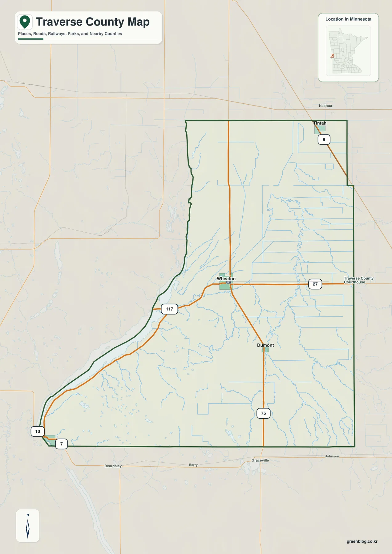
Lake Traverse and the Bois de Sioux River also explain why the western county line should not be read as a simple survey rectangle. Their shoreline and channel form much of the long western edge before the boundary tightens toward Browns Valley. The supplied county image is appropriate for seeing communities, highways, and the county outline together; a parcel boundary or ownership question still requires the recorded legal source for the specific property.
Direct distance from Wheaton clarifies the four-community layout
The city graphic removes most physical detail and focuses on Wheaton, Dumont, Tintah, and Browns Valley. From Wheaton, Dumont is labeled at roughly 7 miles, Tintah at about 16 miles, and Browns Valley at about 22 miles. Those values are straight-line distances printed on the graphic, not road mileage. They give a compact comparison of spacing and direction before the highway routes are added back in.
Dumont’s short separation from Wheaton matches their shared U.S. 75 corridor. Tintah is farther away and displaced to the northeast near MN 9, so it does not sit on the same north-south line. Browns Valley is farther still and occupies the opposite southwest corner against Lake Traverse. That arrangement makes the four communities easy to distinguish by direction even before road turns and water barriers are considered.
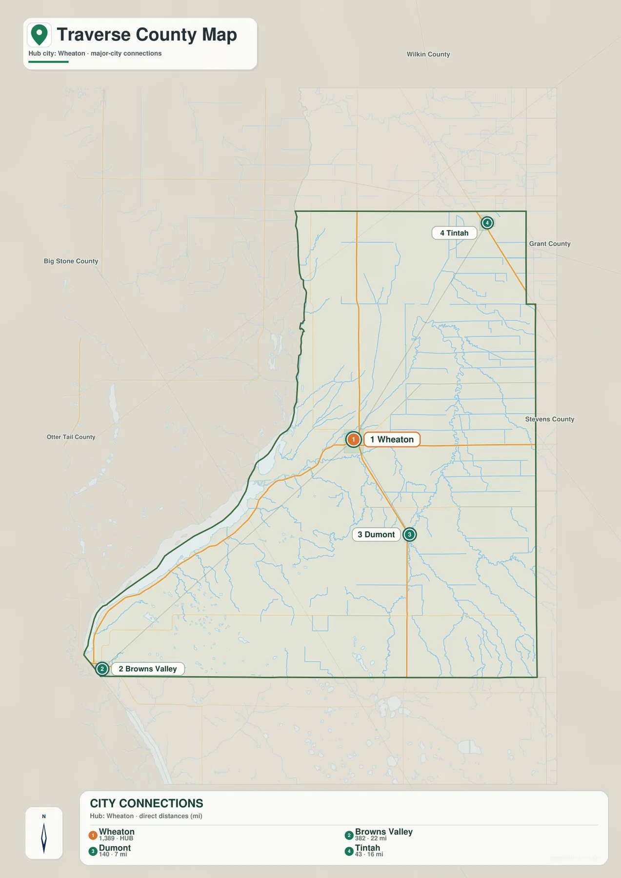
The distance labels should not be converted directly into travel time. The route toward Browns Valley is a good example: the lake-edge shape of the county and the available roads mean that a driving path does not follow the straight line printed on the city graphic. For trip planning, current road directions remain the correct source.
Lake Traverse and the Mustinka River divide the water picture
Lake Traverse dominates the county’s western water edge, extending south toward Browns Valley and feeding the Bois de Sioux River at its northern outlet. Traverse County’s official history page specifically describes Lake Traverse and the Bois de Sioux in connection with the state and county boundary. That relationship is visible on the map: the western edge follows broad water features rather than the straighter geometry found along much of the east side.
The interior water network has a different shape. The Mustinka River bends through the west-central county, with Eighteen Mile Creek and Eightmile Creek joining the surrounding drainage. Farther east, Five Mile Creek and branches of Twelve Mile Creek form longer, narrower lines. Wet Lake and Saint Marys Lake appear in the southern part of the map as smaller standing-water features. The result is a county with one large water boundary and a separate set of inland river and creek corridors.
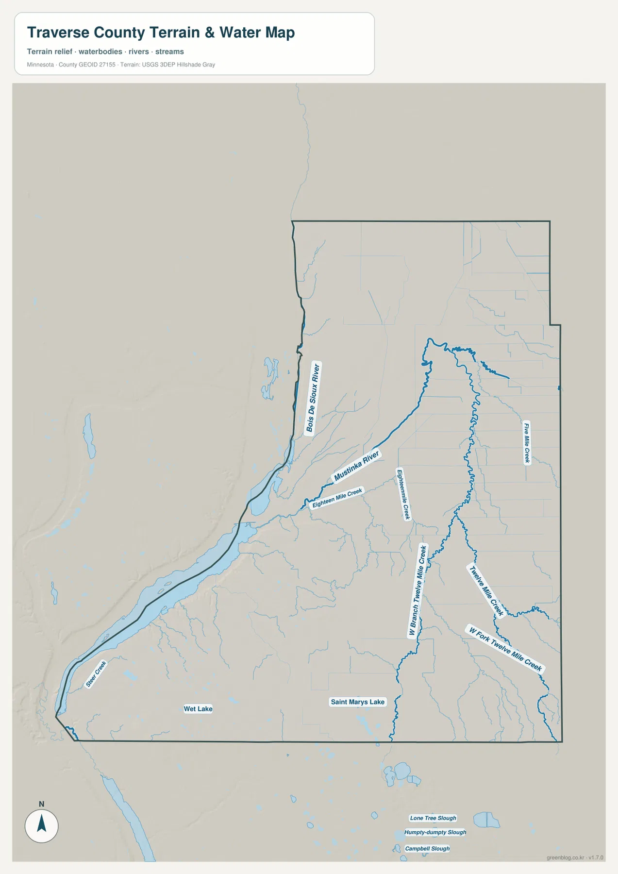
The water layer identifies names and locations; it does not encode depth, current flow, flood forecasts, ice safety, or boating conditions. Those conditions can change independently of the map. Anyone going onto Lake Traverse or using land near a river or creek should rely on current hydrologic, weather, and local safety information for the actual date of travel.
A 294–365 meter range is most visible east of Browns Valley
The elevation legend gives an actual county range of about 294 to 365 meters, with a mean near 319 meters. The lowest green tones follow Lake Traverse and the Bois de Sioux side of the county and continue through much of the northwest. Immediately east of Browns Valley, however, the colors climb quickly through yellow and tan into the darkest southwestern high ground. That abrupt local rise is the strongest relief contrast on the supplied elevation map.
From the southwest high ground, elevation eases toward the south-central and eastern parts of the county. The Mustinka River and several creeks occupy lower strips that cut through surrounding terrain, so the water network becomes easier to place when the elevation and hydrography images are compared. A relief difference of a little more than 70 meters is modest in absolute terms, yet it is substantial enough to prevent the county from appearing uniformly flat at this scale.
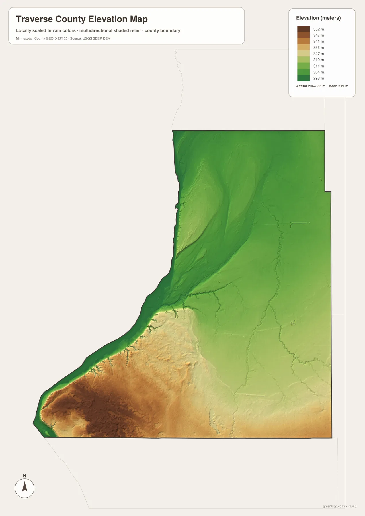
The county history page places this landscape in the former bed of glacial Lake Agassiz and discusses the Browns Valley area in the history of regional drainage. That background fits the broad western lowland and the sharp nearby rise shown here. The shaded elevation surface remains a county-scale depiction, so engineering, construction, drainage design, or a precise site elevation should be based on higher-resolution USGS data or a professional survey.
Wheaton and Browns Valley show two different sides of Traverse County
Wheaton combines the county’s road and settlement information. It is the U.S. 75–MN 27 junction, the central point used for the direct-distance labels, and a community near the Mustinka River system rather than the Lake Traverse shoreline. Browns Valley combines a different set of features: it is the farthest of the three comparison communities from Wheaton, sits beside the southern end of Lake Traverse, and lies immediately west of the county’s steepest rise into higher terrain.
Dumont and Tintah fill in the remaining directions without duplicating either setting. Dumont follows the same U.S. 75 corridor as Wheaton, while Tintah occupies the northeast near MN 9. Reading those four communities against the water and elevation layers turns what first looks like a small set of town labels into a clear west-to-east and southwest-to-northeast geographic arrangement.
For a printed handout that needs roads and boundaries together, the county image carries the most labels. The city image is cleaner when the point is the relative position of Wheaton, Dumont, Tintah, and Browns Valley. The water image isolates Lake Traverse, the Bois de Sioux, the Mustinka River, and named creeks, while the elevation image isolates the 294–365 meter relief pattern. The four JPG originals in the ZIP are 2572×3638 pixels, matching the map subjects shown on the page.
Frequently Asked Questions
How are Dumont, Tintah, and Browns Valley positioned from Wheaton?
Dumont is south of Wheaton on the U.S. 75 corridor, Tintah is northeast near MN 9, and Browns Valley is southwest beside Lake Traverse. The city graphic labels straight-line distances of roughly 7, 16, and 22 miles respectively; driving routes are different.
Which water features define Traverse County most clearly?
Lake Traverse and the Bois de Sioux River dominate the western boundary, while the Mustinka River is the major named interior river. Eighteen Mile Creek, Eightmile Creek, Five Mile Creek, and the Twelve Mile Creek system add smaller drainage lines across the county.
Where is the largest elevation contrast?
The strongest contrast appears between the low Lake Traverse–Bois de Sioux margin and the higher southwestern interior immediately east of Browns Valley. The legend gives a county range of about 294–365 meters with a mean near 319 meters.
Map File Information
The ZIP contains A3 high-resolution JPG originals matching the four Traverse County graphics above.
- Included Files: 4 maps
- File Type: JPG
Related Maps
Sources and references
- Traverse County official history page — Lake Traverse, the Bois de Sioux, Browns Valley, and local landscape history
- U.S. Census Bureau TIGER/Line Shapefiles — county boundaries and road context
- USGS National Hydrography — rivers, creeks, and lakes
- USGS 3D Elevation Program — elevation and terrain reference
Green Map creates custom-edited map images using open geographic data sources such as geoBoundaries, Natural Earth, OpenStreetMap, and government open data. These maps are edited visual materials, not raw data files, and are provided for education, documents, presentations, and graphic reference.