Swift County stretches across west-central Minnesota with Benson near the middle of the county, Appleton near the southwest corner, and a string of smaller communities extending east toward Murdock and Kerkhoven. The road pattern is easy to recognize once Benson is used as the main reference point: U.S. 12 heads southeast, MN 29 runs south, and MN 9 continues east. Around Appleton, U.S. 59 and MN 7 become more important. The maps on this page also separate out the county’s rivers, lakes, and elevation, and the four original high-resolution JPG files can be downloaded together from the map file box below.
The county looks fairly open and level on the road map, but the water and elevation views add much more detail. The Pomme de Terre River occupies the western side, the Chippewa River runs through the central part of the county, and the East Chippewa River system crosses the northeast. Elevation ranges from roughly 284 to 395 meters, with lower ground around the southwest and river valleys and noticeably higher terrain toward the eastern and northeastern edge. Reading these layers together makes it easier to see why the towns, roads, and waterways form different patterns across the county.
Table of Contents
Benson as the road reference point for Swift County
Benson is the clearest place to begin with the county map because several important routes meet or pass through the city. U.S. 12 enters Benson and continues southeast toward De Graff, while MN 29 runs south from the city. MN 9 heads east, and several county and local roads extend toward the smaller settlements around Benson. This arrangement gives the central part of Swift County a hub-like road pattern without turning the county into a single-corridor landscape. Once Benson is located, the positions of Clontarf, Danvers, De Graff, Murdock, and the other communities become much easier to place.
Appleton creates a second road focus in the southwest. U.S. 59 and MN 7 are prominent there, and MN 119 is also marked near the city. Danvers and Holloway sit between the Benson area and Appleton, so they help show how the western half of the county is organized across broad rural land rather than around continuous urban development. The map also shows rail lines following parts of the same general east-west pattern, reinforcing the long distances between the county’s small communities.
East of Benson, U.S. 12 provides the simplest line for following the county toward De Graff and then toward Murdock and Kerkhoven. The two eastern towns sit closer to the Kandiyohi County side than Appleton does, giving this part of Swift County a very different orientation from the southwest. Clontarf lies north of Benson along a more north-south road pattern. These settlements are not arranged in a neat straight line, which is why a county-wide road map is useful for seeing the different branches at once.
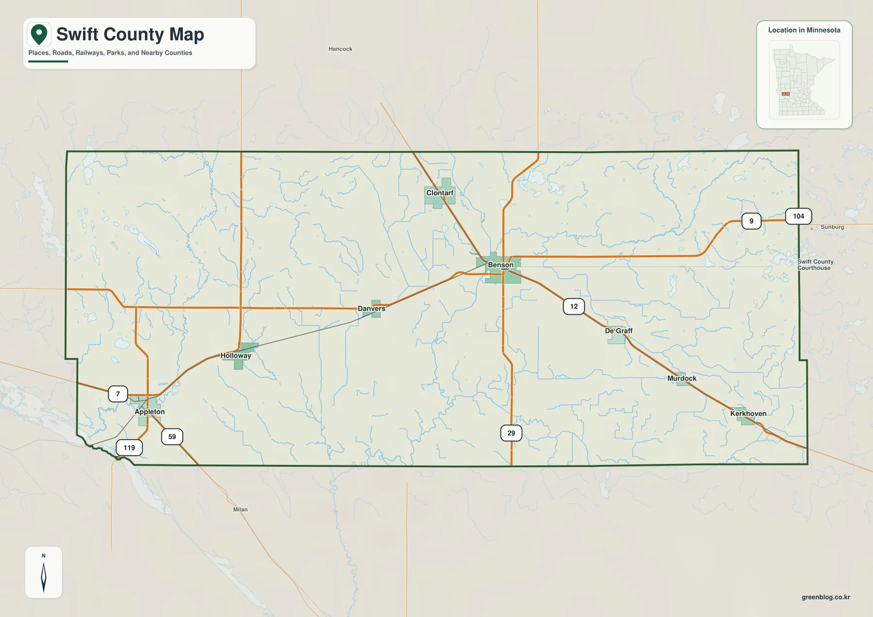
The county map also places Swift County in relation to its neighbors. Pope and Stevens counties appear to the north, Kandiyohi County to the east, Chippewa and Lac qui Parle counties to the west, and Big Stone County near the southwest. That surrounding context is especially helpful when looking at Appleton near the corner of the county or Kerkhoven near the opposite side. The boundary line on this map is intended for general geographic reference rather than parcel work, title research, or legal surveying.
Six towns spread across a long east-west county
The city map strips away much of the road detail and emphasizes six ranked communities: Benson, Appleton, Kerkhoven, Murdock, Danvers, and Holloway. Benson is shown as the largest of the six, with Appleton next, followed by Kerkhoven and Murdock in the east and the smaller Danvers and Holloway in the western half. The ranking values belong to the map’s source snapshot, so they are better treated as a relative guide than as a substitute for current official population estimates. The key geographic point is the amount of space between these communities.
Benson sits closest to the county’s central area, but Appleton is pushed down toward the southwest corner. Kerkhoven and Murdock form a pair in the southeast, while Danvers and Holloway occupy the broad area between Benson and Appleton. That spread explains why different highways matter depending on the destination. A visitor headed for Appleton will pay more attention to U.S. 59 and MN 7, while someone traveling toward Murdock or Kerkhoven is more likely to use U.S. 12 as the main reference.
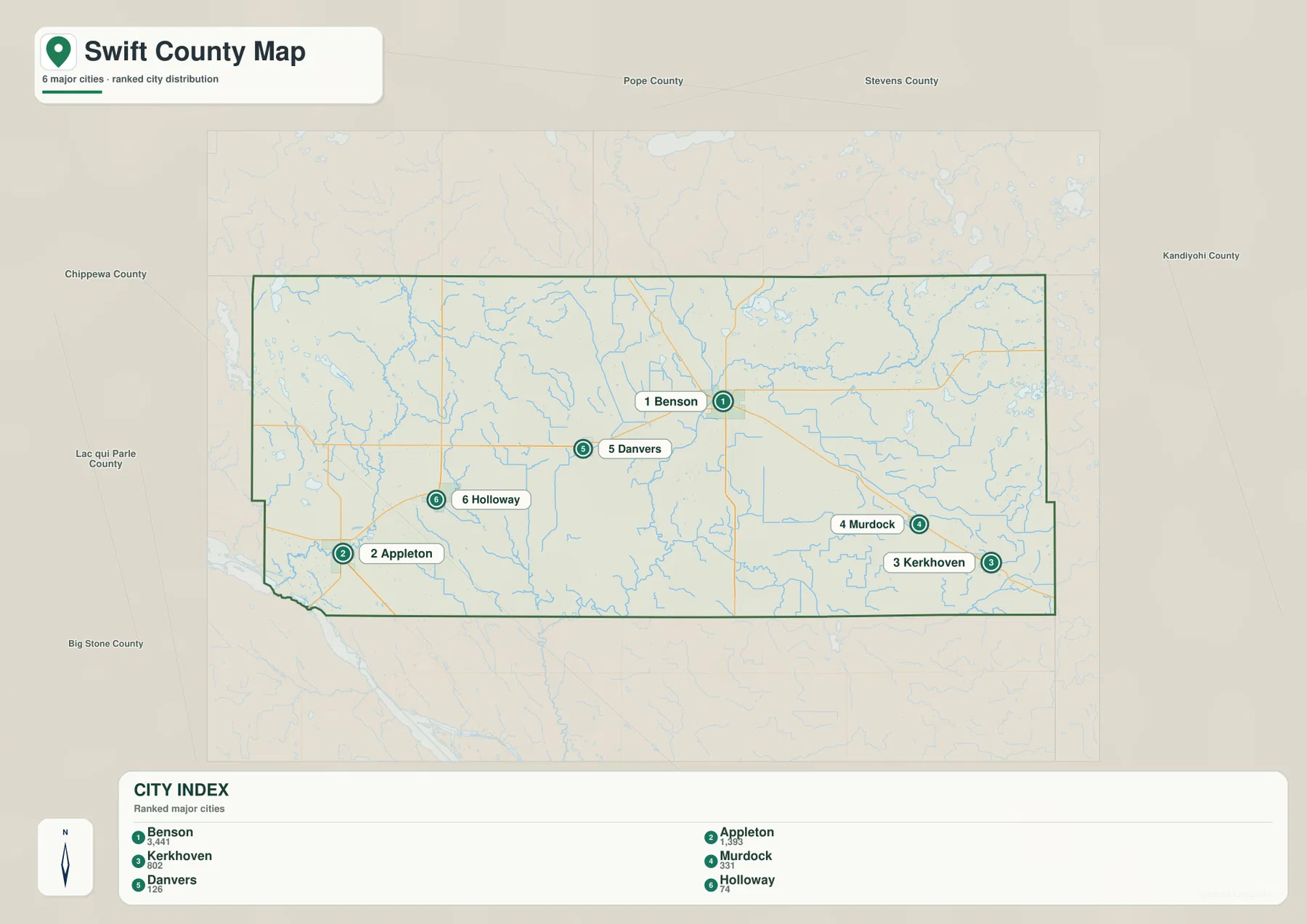
This city-focused map is not a routing map and does not show turn-by-turn driving distance. Its strength is orientation. A student can use it to learn the main place names before moving to the more detailed county map, and someone preparing a regional handout can show where the county’s population centers are distributed without the distraction of every road and stream. Because Swift County is mostly rural, that simplified view makes the contrast between the central town and the widely separated smaller communities especially clear.
Pomme de Terre River, Chippewa River, and the eastern branches
The terrain and water map changes the visual emphasis completely. On the western side, the Pomme de Terre River runs south through a broad low area before approaching the southwest corner. The Chippewa River descends through the central part of the county, while the East Chippewa River and East Branch Chippewa River occupy the northeast and eastern sections. Together, these waterways show that Swift County is not drained by one single river corridor. Different parts of the county belong to different branches of a wider river network.
Several named lakes help anchor the western and eastern water features. Griffin Lake, Lake Oliver, and Shible Lake appear in the west, while Lake Hassel and Lake Moore sit closer to the north-central and northeastern river network. Lake Hollerberg and Lake Monson are farther east. None of these lakes dominates the county in the way a very large lake might, but they make the drainage pattern easier to follow because they provide recognizable points along the smaller streams and low areas.
In the southeast, Mud Creek follows a winding course, and Shakopee Creek is labeled farther south near the central part of the county. These smaller streams are useful reminders that the apparently flat agricultural landscape is cut by many shallow drainage paths. They are less visually prominent than the Pomme de Terre or Chippewa rivers, yet they help explain local relief and why the water map contains far more branching lines than the general road map.
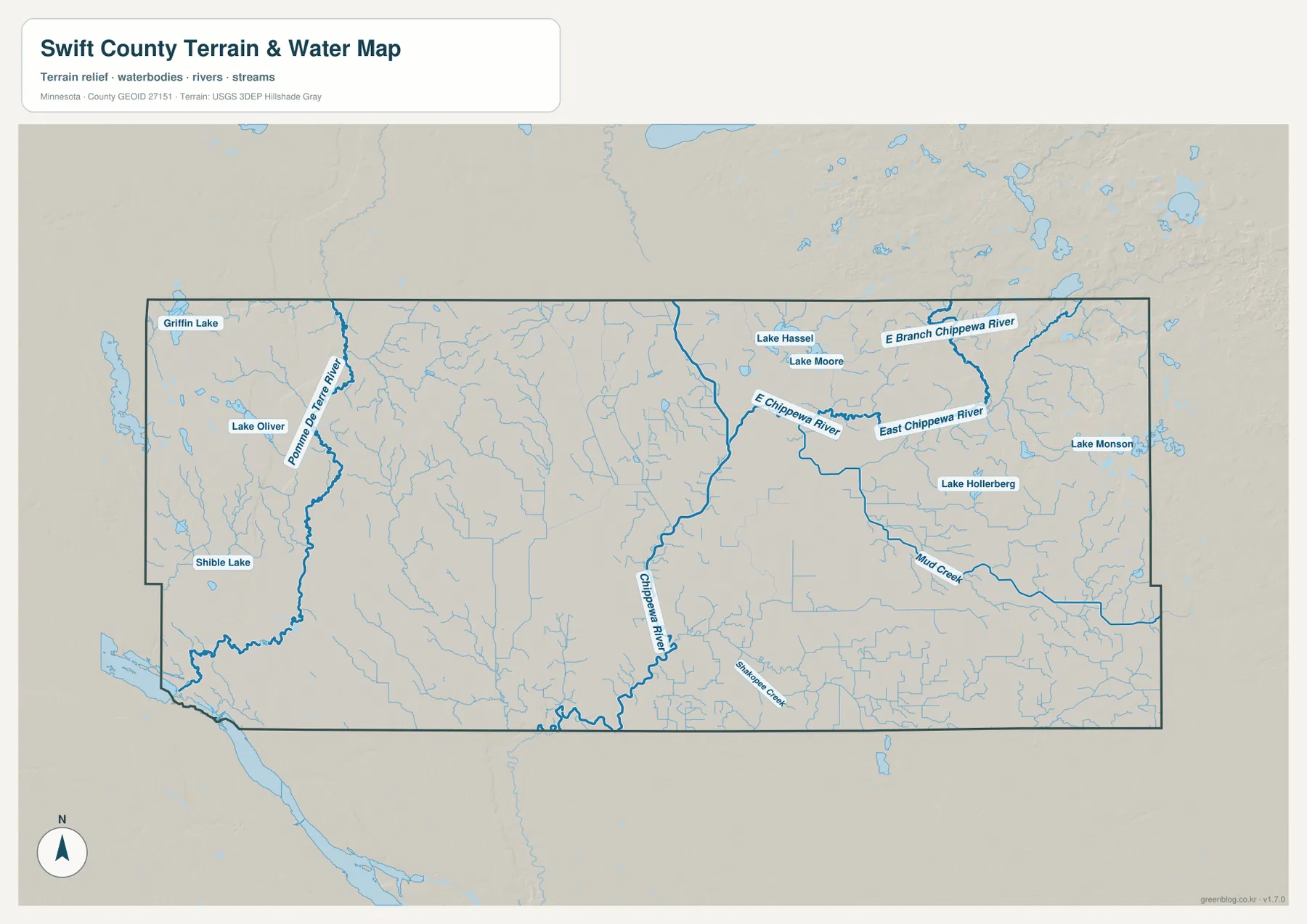
This water map is a reference for the location of rivers, streams, lakes, and surrounding terrain. It should not be read as a flood-hazard map, navigation chart, water-depth survey, or water-quality report. Those questions require current agency data designed for that purpose. For ordinary geographic reading, however, the map is useful for identifying which streams cross different parts of Swift County and how the named lakes relate to the river system.
From 284 meters in the low country to 395 meters near the east
The elevation map gives Swift County a different character than the road map. The legend reports an actual range of about 284 to 395 meters, with a mean near 325 meters. Much of the southwest appears in darker greens, indicating lower terrain, and broad areas across the center remain relatively subdued. The eastern and especially northeastern edges shift into yellow, orange, and brown tones, showing where the county rises onto higher ground. A difference of more than 100 meters is significant enough to create visible regional contrast even though the county has no mountain terrain.
The low corridor around the Pomme de Terre River is particularly easy to recognize on the western side. The central Chippewa River also follows lower ground, though the relief around it is generally gentle. In the northeast, the surface becomes more broken and higher, with small ridges and hills standing out against the broad agricultural plain. Comparing the elevation image with the water map helps explain why the major rivers and smaller streams occupy the routes they do.
Benson lies in relatively moderate terrain rather than at either extreme of the county. Appleton is closer to the lower Pomme de Terre River country, while Murdock and Kerkhoven are positioned nearer the higher eastern side. That difference is almost invisible on the city map but becomes obvious when the colored elevation surface is viewed beside it. For readers trying to understand the county as more than a flat outline, this is one of the most useful comparisons in the map set.
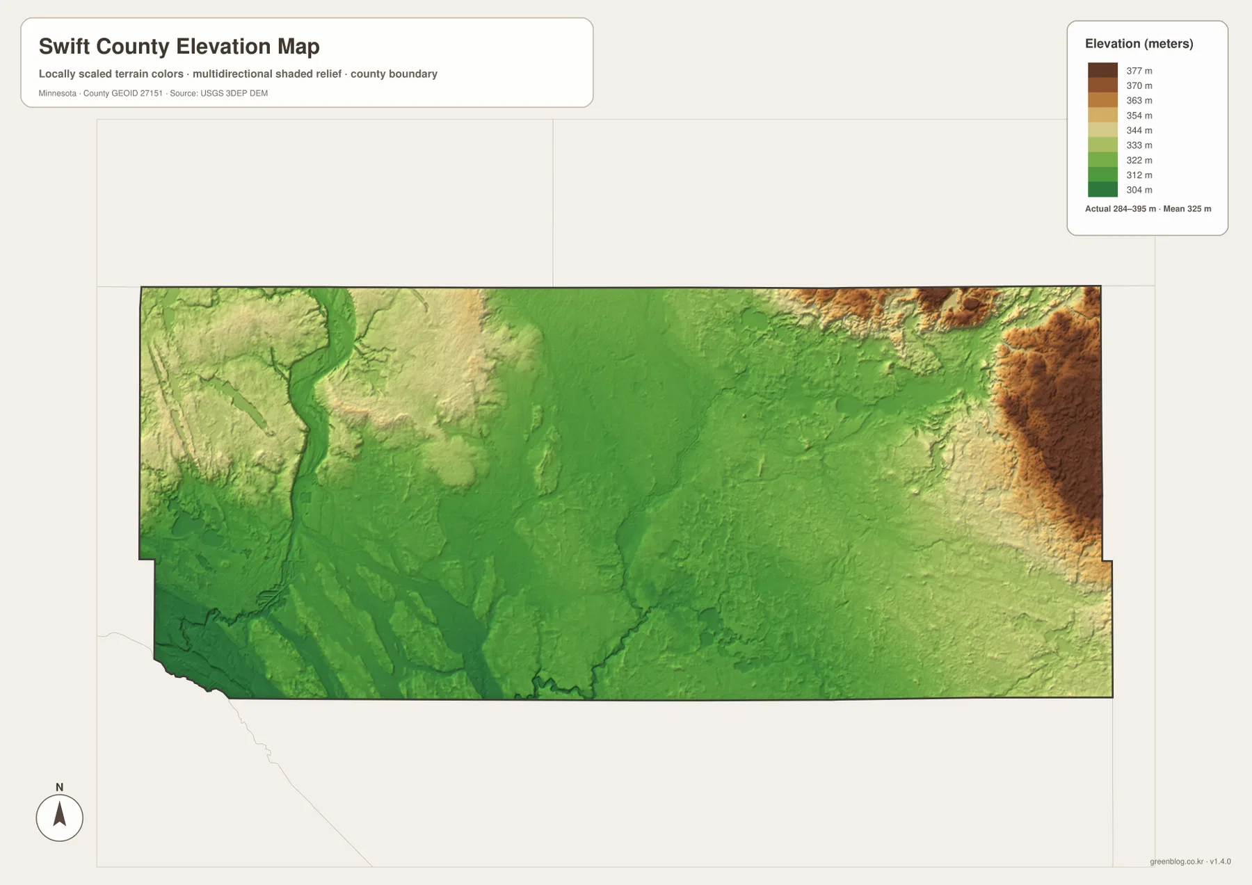
The elevation surface is generalized for county-scale comparison. It is not survey-grade measurement and should not be used to determine a building elevation, drainage design, parcel height, or engineering benchmark. Detailed work requires the underlying USGS elevation data or professional survey information. Here, the purpose is to show the broad difference between the low southwest, the river corridors, and the higher eastern margin.
How roads and rivers explain the county better together
The four map views become most useful when the same place is compared across them. Benson is a good example. On the county map, it is defined by U.S. 12, MN 29, MN 9, and several local connections. On the water map, the Chippewa River system becomes the main natural feature in the surrounding area. The elevation map then shows that Benson sits in relatively gentle terrain between lower river corridors and the higher land farther east. Each map adds a different piece without changing the location itself.
Appleton works the same way. The road map emphasizes U.S. 59 and MN 7, while the water map places the city near the Pomme de Terre River system and the low southwest corner of the county. The elevation view confirms that this part of Swift County is lower than the northeastern edge. Murdock and Kerkhoven show the opposite tendency: they remain tied to U.S. 12 on the road map but sit closer to the higher eastern terrain and the East Chippewa drainage network.
Smaller places such as Clontarf, Danvers, and Holloway are also valuable orientation points. Clontarf helps define the area north of Benson, while Danvers and Holloway break up the long distance toward Appleton. Because the county has relatively few large settlements, these smaller names make it easier to remember where roads cross rivers and how the western half differs from the eastern half. A reader who learns those points can move between the four maps without losing geographic context.
Choosing the most useful Swift County map file
For a general overview, the county map is the best starting file because it combines the county boundary, towns, major highways, rail lines, and nearby county names. The city map is cleaner when the main goal is to compare where Benson, Appleton, Kerkhoven, Murdock, Danvers, and Holloway sit relative to one another. Those two views are similar enough to complement each other but different enough that the simplified city view can be easier for classroom slides or quick orientation.
The water map is the better choice for work centered on the Pomme de Terre River, Chippewa River, East Chippewa River, and the smaller named lakes and creeks. For terrain, the elevation map clearly shows the low southwest and the rising eastern edge across the 284–395 meter range. When a project needs both human and physical geography, placing the road map next to either the water or elevation map is usually more informative than trying to force every feature into a single image.
The WebP images in the article are optimized for quick viewing. The downloadable archive contains the same four maps as original high-resolution JPG files at 3638×2572 pixels each, making small labels and shaded relief easier to inspect or print. These maps are intended for general reference, education, presentations, and personal use. They are not substitutes for live navigation, legal boundary research, flood analysis, or engineering survey work.
Frequently Asked Questions
Which highways are most useful for locating Benson and Appleton?
Benson is easiest to locate by U.S. 12, MN 29, and MN 9. Appleton sits near U.S. 59 and MN 7, with MN 119 also marked nearby. Danvers and Holloway help bridge the western space between the two larger towns. For actual driving, current road conditions and navigation sources should be checked separately because this map does not provide live routing information.
What are the main rivers shown in Swift County?
The western part of the county is crossed by the Pomme de Terre River, the Chippewa River runs through the central area, and the East Chippewa River with its east branch occupies the northeast and east. Mud Creek and Shakopee Creek are among the smaller named waterways. The map is designed to show location and terrain context rather than flood risk, flow volume, or water quality.
How much elevation change appears across Swift County?
The elevation legend gives an actual range of about 284 to 395 meters and an average near 325 meters. Lower terrain is concentrated in the southwest and along river corridors, while the eastern and northeastern edge rises onto higher ground. The image is useful for county-scale comparison but is not precise enough for surveying, construction, or parcel-level elevation work.
Map File Information
The ZIP contains the high-resolution JPG originals for the Swift County boundary map, city map, water map, and elevation map used on this page.
- Included Files: 4 high-resolution JPG maps
Related Maps
Sources and references
- Swift County official website — county government and local information
- U.S. Census Bureau TIGER/Line Shapefiles — county boundaries, roads, and place references
- USGS National Hydrography — rivers, streams, and lake reference data
- USGS 3D Elevation Program — elevation and terrain reference data
Green Map creates custom-edited map images using open geographic data sources such as geoBoundaries, Natural Earth, OpenStreetMap, and government open data. These maps are edited visual materials, not raw data files, and are provided for education, documents, presentations, and graphic reference.