Pope County is easiest to orient around Lake Minnewaska, the broad lake near the north-central part of the county. Glenwood sits at its eastern end, Starbuck lies along the southwestern side, and Long Beach occupies the northwestern shore. From that lake-centered core, smaller communities spread outward toward Lowry and Villard in the north, Cyrus near the western boundary, and Sedan along the southeastern road corridor. The county map makes those relationships more useful than a simple list of place names because roads, water, and settlement are visible together. High-resolution map files are available for download in the section below.
The page includes a county overview, a ranked city-distribution map, a terrain-and-water map, and an elevation map. High-resolution JPG originals can also be downloaded for printing or closer viewing. Rather than treating the maps as four separate inventories, the guide below follows the county itself: first the Lake Minnewaska road pattern, then the outer communities, drainage, and relief that explain why places occupy different parts of Pope County.
Table of Contents
Lake Minnewaska anchors the Glenwood–Starbuck road pattern
On the county overview, Lake Minnewaska is the most recognizable landmark and a practical starting point for reading the rest of the map. Glenwood is positioned at the eastern end of the lake where several highways converge, while Starbuck sits near the southwest side and Long Beach hugs the northwestern shore. Once those three places are located, Villard, Lowry, Cyrus, and Sedan become much easier to place in relation to the county center.
Minnesota Highway 28 crosses the county from the west, passes Starbuck, continues along the north side of Lake Minnewaska, and reaches Glenwood before heading toward Villard and Westport. Highway 29 runs south from the Glenwood area, and Highway 55 leaves toward Sedan and Brooten in the southeast. Highway 114 approaches from the northwest. The result is a road pattern in which Glenwood functions as a clear junction while the large lake bends the east-west route around its northern side.
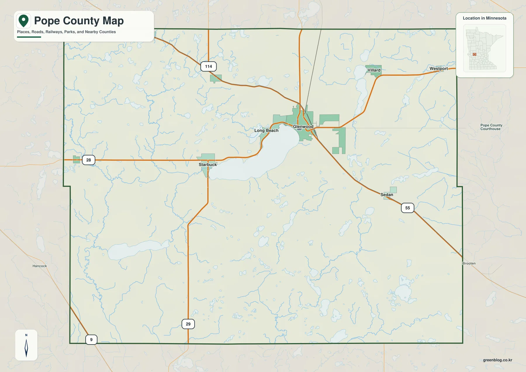
Names just beyond the county line add useful context. Hancock appears to the west, Westport to the east, and Brooten southeast of the county. They show where the main roads continue after leaving Pope County, but the overview is not intended to replace a turn-by-turn road map. Construction, closures, address-level routing, and current travel times should be checked with current transportation sources.
Six selected communities show a lake-centered core and a wider rural spread
The ranked city-distribution map highlights six communities: Glenwood, Starbuck, Cyrus, Lowry, Long Beach, and Villard. The printed values are 2,633 for Glenwood, 1,235 for Starbuck, 438 for Lowry, 355 for Cyrus, 318 for Long Beach, and 236 for Villard. They are the values used by this ranked city layer; they are not mileage figures. The map does not draw connector lines between the communities, so it should not be read as either straight-line distance or driving distance.
The geography behind the ranking is as useful as the numbers. Glenwood, Starbuck, and Long Beach cluster around different sides of Lake Minnewaska, which gives the county a recognizable center. Lowry sits farther northwest and Villard farther northeast, while Cyrus occupies a distinctly western position near the county edge. The selected places therefore show both the concentration around the lake and the much broader spacing of smaller communities outside that core.
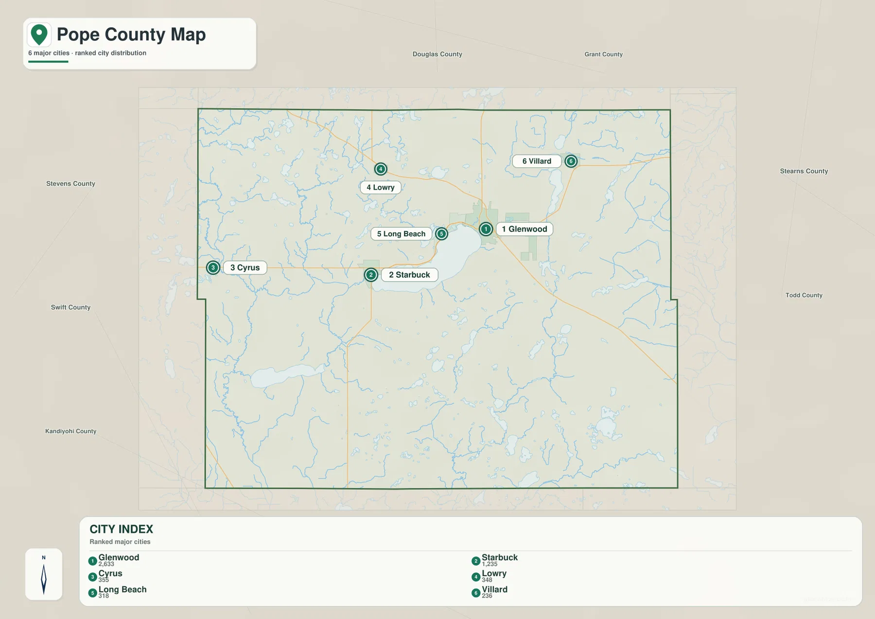
Comparing this layer with the road map explains several connections that the ranking alone cannot show. Villard lies near Highway 28 on the northeastern side of the county, and Lowry is tied to the northwestern approach toward Glenwood. Cyrus is separated from the lake-centered core but remains connected toward Starbuck. Sedan is a useful reminder that the city layer is selective: it appears on the county overview but not in the six-city ranking. This is a comparison map, not a complete municipal register.
A large lake and several Chippewa River branches shape different drainage areas
The terrain-and-water map gives Lake Minnewaska the largest visual footprint, but the county contains several other named waters. Pelican Lake and Trappers Run lie just north of Minnewaska. Villard Lake and Amelia Lake appear farther northeast, while Lake Emily is separated to the southwest. Goose Lake, Lake Simon, and Lake Johanna add another group of water bodies in the southern and southeastern part of the county. Together they show that the county water landscape extends well beyond its best-known lake.
The river network forms a different pattern. The Little Chippewa River descends through the northwest and joins the broader Chippewa River system along the western side. Outlet Creek occupies the area southwest of Lake Minnewaska. Farther east, the East Branch Chippewa River runs through a separate corridor, and Mud Creek appears near the southeastern edge. Instead of a single river crossing the county from end to end, Pope County contains several lower drainage routes separated by higher ground.
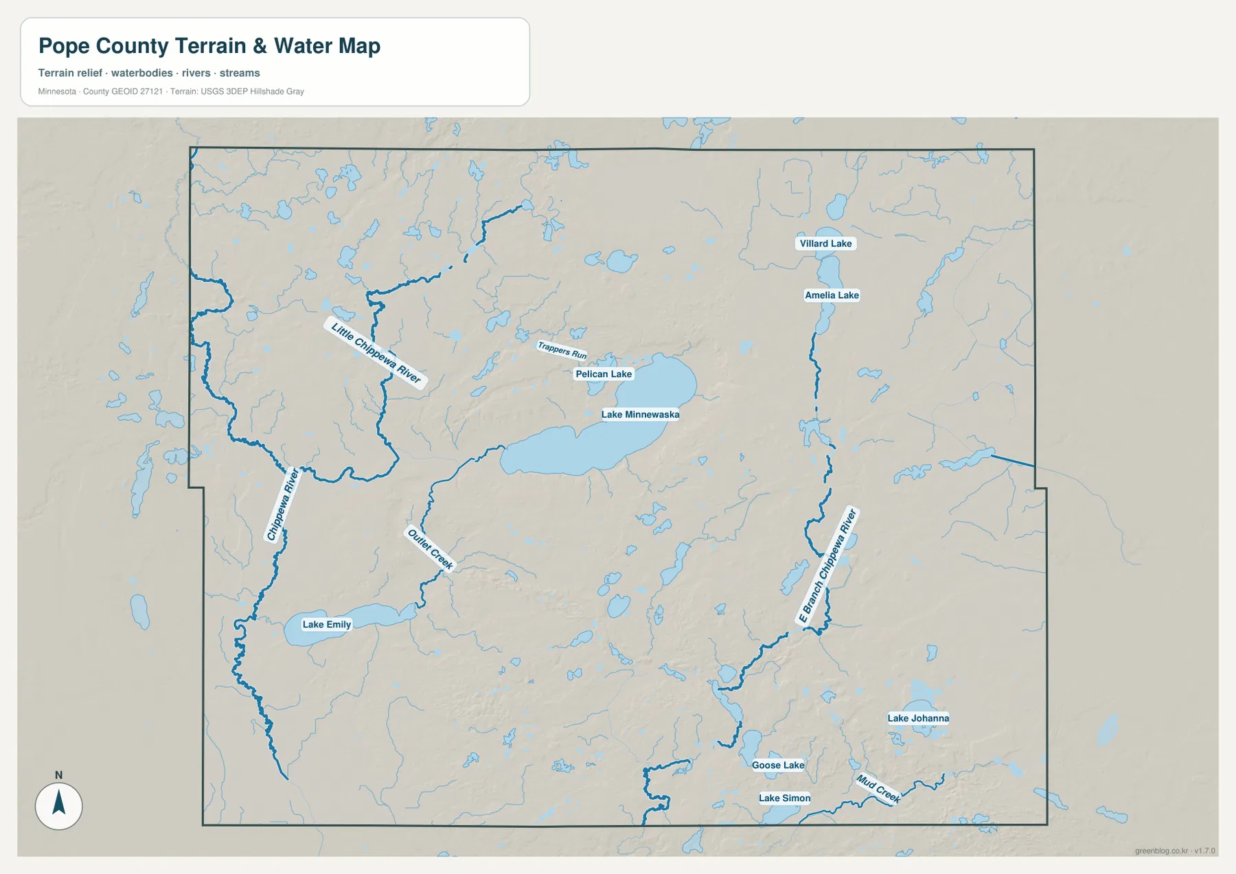
This layer is a geographic reference, not a flood-hazard or navigation product. A blue lake or river does not establish water depth, boating access, shoreline ownership, flood risk, or legal boundaries. Minnesota DNR and Pope County sources are better choices for current management or regulatory information. For map reading, the value here is simpler: it shows where the major lakes and named channels sit relative to the county boundary and surrounding terrain.
Lower ground around Minnewaska contrasts with higher northern and eastern terrain
The elevation map shows an actual mapped range of about 319 to 446 meters and a mean near 385 meters. The Lake Minnewaska basin and much of the western and southwestern drainage area are rendered in lower green tones. Higher tan and brown terrain becomes more extensive north of the lake, across the northeast, and through much of the eastern side of the county. The colors make the contrast immediately visible without requiring a reader to interpret individual contour lines.
The pattern is more complicated than a steady slope in one direction. Stream valleys and small basins cut through the higher terrain, while ridges and rolling uplands separate the lower corridors. Around Glenwood, the low lake edge meets higher ground over a relatively short distance. Around Starbuck, the low Minnewaska shore transitions toward the lower Chippewa drainage to the west and southwest. Those differences help explain why the same lake can sit next to noticeably different relief on opposite sides.
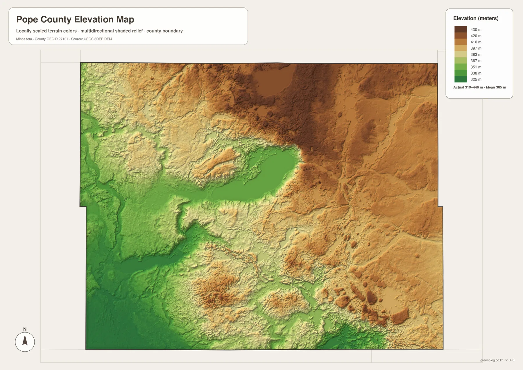
The shaded elevation image is designed for regional comparison rather than engineering measurement. It should not be used to determine a building-pad elevation, road grade, levee height, or property-corner elevation. For those purposes, use detailed USGS elevation data and appropriate survey information. As a county reference, however, the map clearly shows why lakes and streams tend to occupy lower corridors while broad uplands dominate many northern and eastern areas.
Glenwood, Starbuck, and Villard reveal how the map layers fit together
Glenwood brings several county themes together in one place. It is the county seat at the eastern end of Lake Minnewaska, the point where Highways 28, 29, and 55 meet or branch, and the highest-valued location in the selected city ranking. The relief also changes quickly around the city because the low lake basin gives way to higher ground to the north and east. That makes Glenwood a useful place to compare settlement, transportation, water, and terrain without reducing the explanation to a checklist of map types.
Starbuck provides a different perspective on the same lake. It lies near the southwestern shore and Highway 28, with lower terrain extending toward the western Chippewa River system. Long Beach occupies the northwestern shoreline between the two major lake-side centers. These communities demonstrate that Lake Minnewaska is not simply a water feature in the middle of the map; it organizes road placement and the most visible cluster of settlements in northern Pope County.
Villard and Cyrus show how quickly that pattern changes toward the edges. Villard lies northeast of Lake Minnewaska near Highway 28 and close to Villard Lake and Amelia Lake, while Cyrus is near the western boundary and more detached from the lake-centered cluster. Sedan, along Highway 55 in the southeast, appears on the broader county map even though it is absent from the six-city ranking. These differences are useful when deciding whether a reader needs a complete orientation map or a simplified city comparison.
Choose the Pope County file by the question you need to answer
For general orientation, the county overview is the best starting point because it combines the boundary, major roads, communities, and Lake Minnewaska on one page. The city-distribution layer is cleaner when the goal is to compare selected communities without the visual weight of every road. The terrain-and-water map is the practical choice for named rivers, streams, and lakes, while the elevation image works best when the question concerns low basins, drainage corridors, and higher uplands.
The ZIP below contains the original JPG versions at 3638 × 2572 pixels each. They retain more detail than the WebP previews used in the article and are suitable when you need a larger copy for print, classroom material, or a presentation. The maps remain general geographic references. Parcel ownership, legal boundaries, flood determinations, precise engineering elevations, and live road conditions should be checked against the appropriate current official source.
Frequently Asked Questions
How are Glenwood and Starbuck positioned around Lake Minnewaska?
Glenwood is at the eastern end of Lake Minnewaska, while Starbuck is near the southwestern side. Highway 28 connects the lake-side corridor, and Long Beach lies on the northwestern shore. Together those three places provide an easy framework for locating the rest of northern Pope County.
Are the values 2,633 and 1,235 on the city map distances?
No. They are the values printed for the selected communities in the ranked city layer, not straight-line or driving distances. The map does not include connector lines between the cities. Use a current road or navigation service when you need an actual travel distance.
Where is the clearest low-to-high elevation contrast in Pope County?
A strong contrast appears between the lower green terrain around Lake Minnewaska and the higher tan and brown ground north and east of the lake. The western and southwestern Chippewa drainage is also relatively low, while stream valleys interrupt the higher eastern uplands. Viewing the water and elevation maps together makes the relationship especially clear.
Map File Information
The ZIP contains the four original high-resolution JPG maps described on this page. They are larger than the article previews and are useful when you need a clearer copy for printing, classroom material, or presentation work.
- Included Files: Use only the versions confirmed in the article and supplied images
- File Type: Use the confirmed download contents
- Intended Use: Printing, education, presentations, and map-based projects
Related Maps
Sources and reference links
The description above uses the supplied Pope County maps together with the following official or authoritative references. These sources are appropriate when you need current county administration, transportation, water-management, hydrography, or elevation information beyond the simplified maps on this page.
- Pope County official website — county administration and local information centered in Glenwood
- Minnesota DOT Pope County Maps — official county road and community map resources
- Minnesota DNR Glenwood Area Fisheries — regional water-management context including Lake Minnewaska
- USGS National Hydrography — national river, stream, and waterbody information
- USGS 3D Elevation Program — national elevation data and 3DEP documentation
Green Map creates custom-edited map images using open geographic data sources such as geoBoundaries, Natural Earth, OpenStreetMap, and government open data. These maps are edited visual materials, not raw data files, and are provided for education, documents, presentations, and graphic reference.