Olmsted County is centered on Rochester, but the maps show a landscape that is far more varied than a single urban core. U.S. 52, U.S. 14, and U.S. 63 converge around Rochester, while Byron, Oronoco, Stewartville, Eyota, and Dover spread into different parts of the county. Beneath that road network, branches of the Zumbro River occupy lower valleys and the eastern half becomes increasingly dissected by ridges and stream corridors. The four map themes shown on the page are also available as high-resolution JPG originals in one downloadable ZIP.
Rochester is the most useful reference point for reading the county because roads, settlement, and waterways all meet nearby. U.S. 52 links the Oronoco side in the north with Stewartville to the south, while U.S. 14 runs west through Byron and east toward Eyota and Dover. The Zumbro drainage crosses the central and northern area, and higher ridges become much more obvious east and southeast of Rochester. Looking at those features together gives a clearer picture of Olmsted County than using a road map alone.
Table of Contents
Rochester as the Junction for U.S. 52, 14, and 63
The county overview makes Rochester the dominant settlement and transportation center. U.S. 52 passes the city from north to south, U.S. 14 crosses the county from the Byron side toward Eyota and Dover, and U.S. 63 provides another important north–south reference near the urban area. Oronoco sits north of Rochester close to U.S. 52, while Stewartville is near the southern edge. Marion appears southeast of Rochester, helping define the transition from the large urban footprint to smaller communities and rural roads.
The eastern side has a more fragmented road pattern. Eyota lies on the U.S. 14 corridor, Dover is farther east, and Minnesota 42 and 247 appear in the northeastern area. Near the southeastern boundary, Chatfield is shown outside or along the edge of the county road network, with Minnesota 30 and 74 providing regional connections. These roads cross terrain that becomes more strongly cut by stream valleys, so the straight highway lines contrast with the irregular drainage patterns visible on the water map.
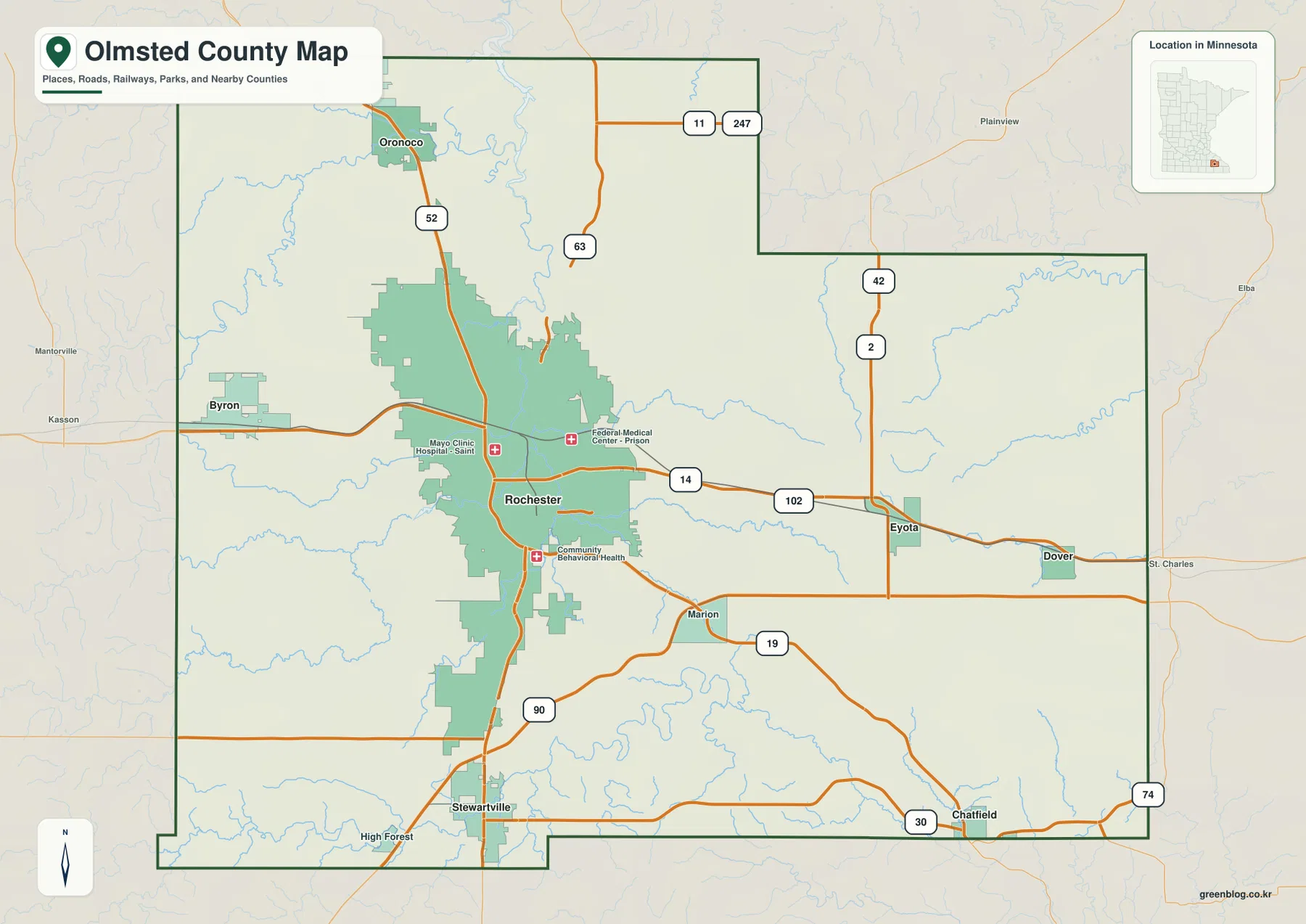
Byron forms the strongest western community on the map, with Rochester’s developed area spreading much more broadly toward the center. The county boundary includes stepped sections in the northeast and south rather than forming a perfect rectangle. This overview is intended for general location, road context, and county-scale orientation; parcel ownership, zoning, and legal survey questions should be checked with official Olmsted County mapping and land records.
Six Major Communities Spread around Rochester
The ranked city distribution map highlights six communities. Its index lists Rochester at 122,330, Stewartville at 6,807, Byron at 6,646, Eyota at 1,944, Oronoco at 1,679, and Dover at 895. Rochester is vastly larger than the other entries, but the map is still useful because the smaller cities occupy distinct directions rather than forming one continuous suburban band.
Byron is west of Rochester, Oronoco is north, and Stewartville lies south, creating three strong reference points around the county’s main city. Eyota is east of Rochester and Dover is still farther east along the same broad side of the county. This arrangement makes the east–west contrast especially clear: the Rochester–Byron side is more urbanized, while the Eyota–Dover side contains smaller communities separated by larger rural areas and stream-cut terrain.
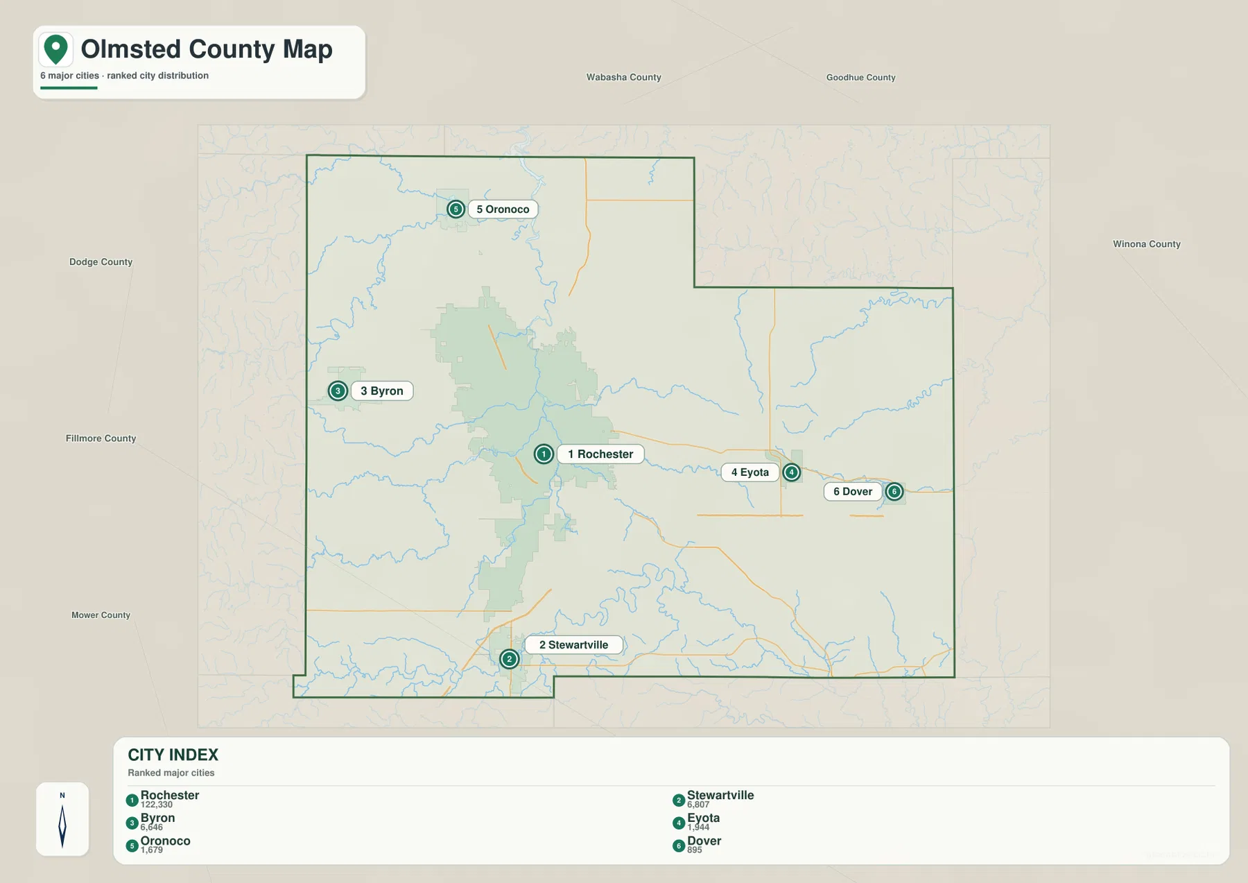
The surrounding labels place Wabasha and Goodhue counties to the north and northeast, Winona County to the east, Fillmore and Mower counties to the south, and Dodge County to the west. That context explains why Byron is close to the western edge while Eyota and Dover sit near the eastern half. The ranked city map is best for relative position and scale; the full county overview should be used when the roads between those communities matter.
Zumbro Valleys Connecting to the Whitewater and Root River Systems
The Zumbro River system provides the central water reference for Olmsted County. The Middle Fork Zumbro River crosses the northern part of the county, while several Zumbro branches and tributaries approach Rochester through lower valleys. Shady Lake, Silver Lake, Mayowood Lake, and Bamber Lake appear as smaller water landmarks within or near this drainage network. The county is therefore more strongly defined by rivers and narrow valleys than by large natural lakes.
East of Rochester, Bear Creek runs into a landscape where the Whitewater drainage becomes more prominent. Fork Whitewater River and Middle Fork Whitewater River occupy separate valleys in the eastern part of the county. To the south, branches of the Root River appear along the lower edge. The map shows three different drainage areas—Zumbro, Whitewater, and Root River systems—rather than one river controlling every part of the county.
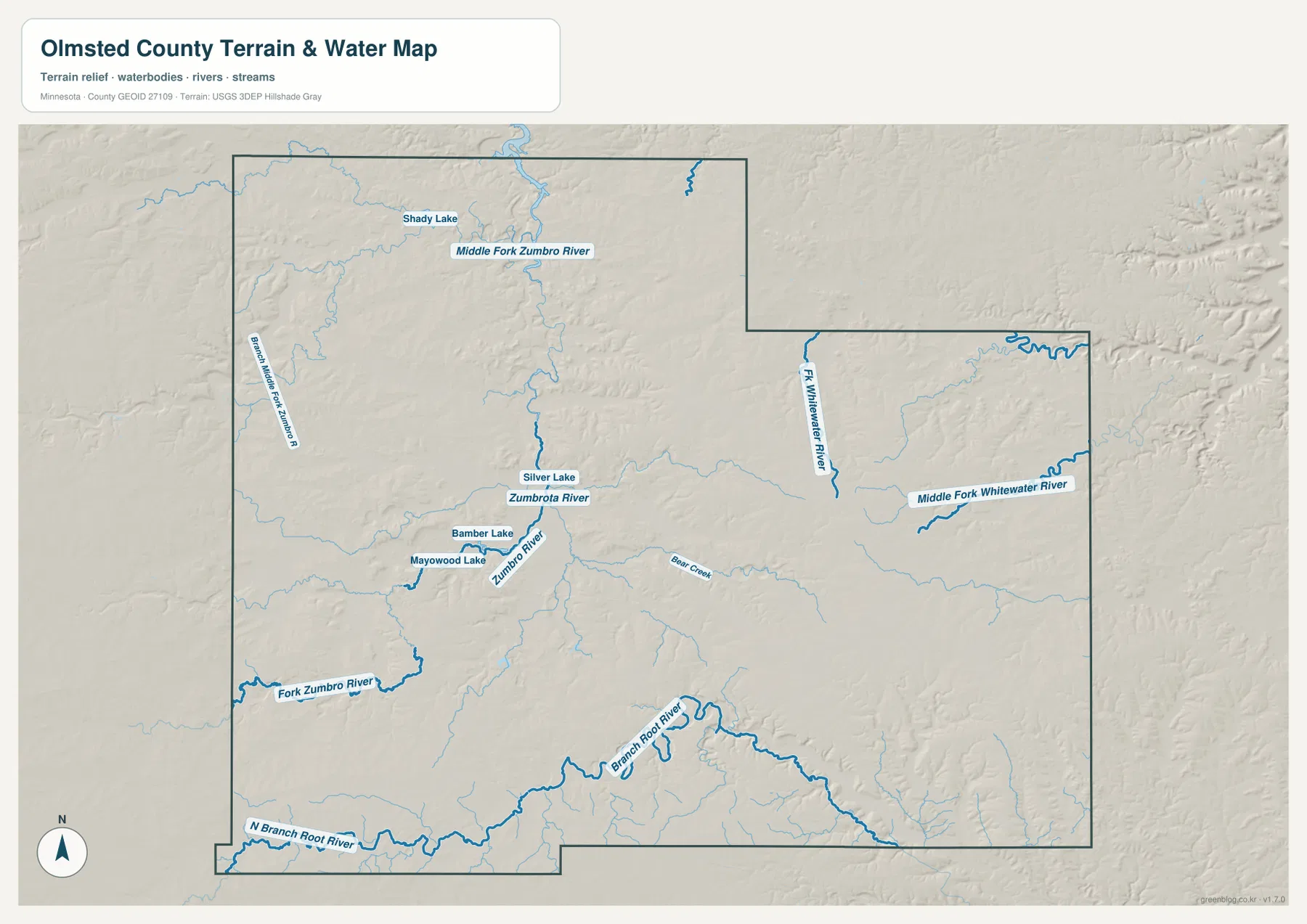
Minnesota DNR describes the Zumbro River in southeastern Minnesota as a river running through a narrow valley with limestone and sandstone bluffs, and its water-trail information includes the Rochester area and nearby tributary branches. That description matches the map’s combination of narrow stream corridors and higher surrounding terrain. The water map is valuable for geographic context, but it does not replace current river-condition or safety information.
This layer is not a floodplain, navigation, depth, shoreline-ownership, or public-access map. Water levels on the Zumbro and its branches can change quickly after rain, and the Whitewater and Root River systems have their own local conditions. Current Minnesota DNR and local information should be used when planning paddling, fishing, or other river activities.
Low Rochester Valleys beneath Higher Eastern Ridges
The elevation map shows why Olmsted County looks so dissected on the water layer. Its legend gives an actual elevation range of about 245 to 420 meters and a mean near 356 meters. The Rochester and Zumbro valley areas are mostly green, indicating lower ground, while large orange and brown uplands spread across the east and southeast. High ridges also appear in the southwest, separated from the central lowlands by narrow valleys.
Moving east from Rochester toward Eyota and Dover, the landscape becomes a repeated sequence of ridges and lower stream corridors. Whitewater River branches occupy green or yellow valleys cut into higher orange-brown terrain. The southeastern side near the Chatfield direction is especially rugged at county scale, with multiple valleys splitting the uplands into long narrow ridges.
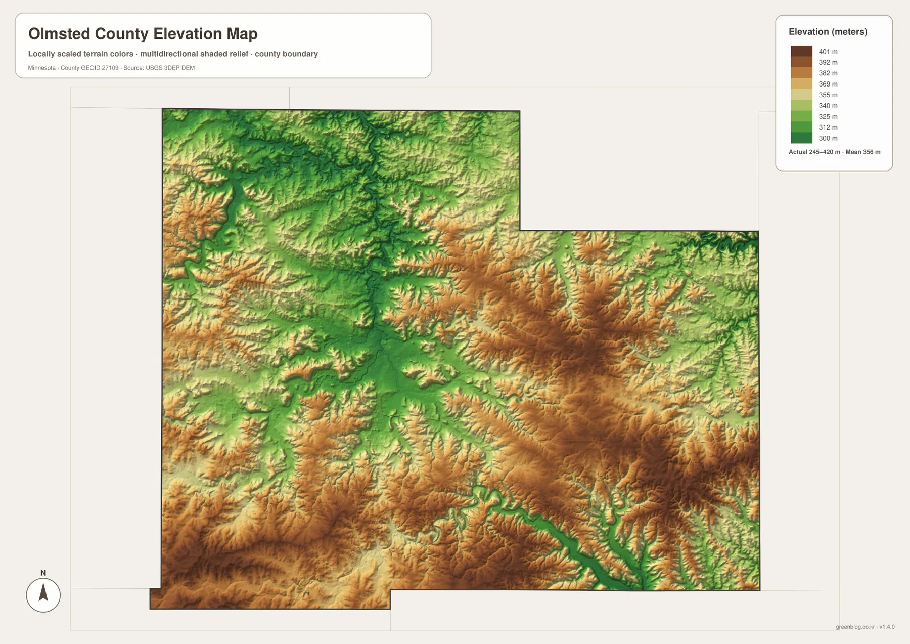
The west and north are not uniformly flat either. Byron sits near rolling higher ground west of the Rochester lowlands, and the Middle Fork Zumbro River cuts a lower route through the northern part of the county near Oronoco. Comparing the elevation and water maps makes the pattern clear: rivers follow low corridors while the land between them remains significantly higher.
The colors are scaled specifically to Olmsted County, so a brown or green shade on another county map may represent a different absolute elevation. The shaded surface is intended for regional interpretation rather than survey-grade use. Engineering, drainage design, construction, and legal elevation work require more precise source data or field measurements.
Choosing a Map for Roads, Rivers, or Ridge-and-Valley Terrain
For roads and city orientation, the county overview is the strongest first choice. It shows how U.S. 52, U.S. 14, and U.S. 63 relate to Rochester and then extend toward Byron, Oronoco, Stewartville, Eyota, and Dover. The ranked city map is better when the goal is to compare the six highlighted communities without the full road network.
For natural geography, begin with the Zumbro branches around Rochester and Oronoco, then look east to the Whitewater system and south to the Root River branches. The elevation view explains why those streams occupy narrow green corridors: much of the surrounding eastern and southeastern ground is substantially higher. Using the water and elevation maps together gives the clearest sense of Olmsted County’s ridge-and-valley terrain.
The WebP previews on the page are optimized for quick viewing. The ZIP contains the corresponding high-resolution JPG originals for the county overview, city distribution, water, and elevation maps. Each file is 3638 by 2572 pixels, making the originals better for printing or zooming into small highway, creek, and city labels than a browser screenshot.
A practical way to understand the county is to start in Rochester, compare Byron to the west and Oronoco to the north, then follow the eastern road corridor through Eyota toward Dover. After that, switch to the water and elevation maps to see how the Zumbro, Whitewater, and Root River systems occupy lower valleys between higher ridges. That sequence connects the county’s settlement pattern directly with its terrain.
Frequently Asked Questions
Which map is best for locating Rochester and the major highways?
Start with the county overview. It shows U.S. 52, U.S. 14, and U.S. 63 around Rochester and places Byron, Oronoco, Stewartville, Eyota, and Dover in the same view. The ranked city map is useful as a second step when relative city size and direction matter more than road detail.
How are the main river systems divided across Olmsted County?
The Zumbro system dominates the central and northern area around Rochester and Oronoco. Whitewater River branches occupy the eastern side, while Root River branches appear along the south. The water map shows that these drainages use separate valleys rather than forming one simple county-wide river channel.
Where is the highest terrain on the elevation map?
The broadest high ground appears in the east and southeast, with additional high ridges in the southwest. The legend shows an actual county range of about 245–420 meters and a mean near 356 meters. Rochester and the major stream valleys are generally lower, while ridges between the valleys rise sharply above them.
Map File Information
The ZIP contains the original high-resolution JPG versions of the Olmsted County overview, city distribution, water, and elevation maps.
- File Type: ZIP containing 4 JPG files
Related Maps
Sources and References
- Olmsted County official website – county government and local information
- Minnesota DNR Zumbro River State Water Trail – Rochester-area Zumbro River and southeastern Minnesota river-valley context
- U.S. Census Bureau TIGER/Line Shapefiles – county boundaries and geographic reference data
- USGS National Hydrography – river, stream, and lake reference data
- USGS 3D Elevation Program – elevation reference data
Green Map creates custom-edited map images using open geographic data sources such as geoBoundaries, Natural Earth, OpenStreetMap, and government open data. These maps are edited visual materials, not raw data files, and are provided for education, documents, presentations, and graphic reference.