Norman County sits in northwestern Minnesota where the flat Red River valley on the west gives way to noticeably higher ground toward the east. Ada is the main community near the center, Twin Valley and Gary are farther east, and Halstad, Hendrum, and Shelly line up close to the western river boundary. This page connects those settlement patterns with the Marsh River, Wild Rice River, drainage channels, and the county’s large west-to-east elevation change. The WebP previews are designed for quick viewing, and the four matching high-resolution JPG maps can be downloaded together in a ZIP. High-resolution map files are available for download in the section below.
A simple way to orient the county is to start at Ada and then compare the two sides. Ada sits near several numbered routes in the central plain, while the western edge follows the winding Red River of the North along the Minnesota–North Dakota state line. Twin Valley and Gary lie toward the higher eastern half. That basic west–center–east layout makes the county easier to understand before moving to the more detailed river and elevation maps.
Table of Contents
The Red River Boundary and Ada’s Central Road Network
The county overview shows a striking difference between the western boundary and the rest of Norman County. The west side follows the curves of the Red River of the North rather than a straight survey line, with Shelly, Halstad, Hendrum, and Perley positioned near that edge. Ada is farther inland and functions as the main central reference, while Gary and Twin Valley are placed well to the east. The pattern makes the county feel wider east to west than a simple list of towns would suggest.
Several highways help organize the interior. Minnesota 9 passes the Ada area north to south, while Minnesota 18, 19, and 200 create east–west references around the center. Minnesota 1 runs across the northern part of the county, and Minnesota 3 and 5 provide additional north–south routes farther east. Twin Valley is reached through a different network in the southeast, where Minnesota 32, 33, 34, and 113 are labeled on the map.
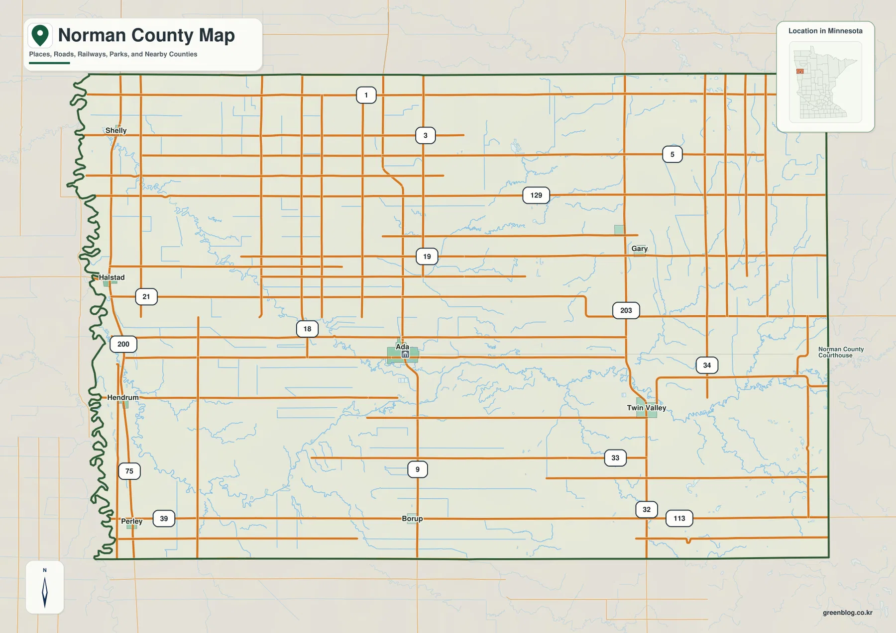
The eastern boundary is much straighter than the river-cut west, and the road grid is more regular across much of the interior. That contrast is useful when moving between map scales: roads near the Red River adapt to the winding boundary, while many inland roads follow long straight sections. The overview is meant for general orientation and road context, not parcel ownership, zoning, or legal survey work.
A Split Settlement Pattern from the River Edge to Twin Valley
The ranked city distribution map highlights six communities. Its index lists Ada at 1,833, Twin Valley at 719, Halstad at 509, Gary at 268, Hendrum at 240, and Shelly at 229. Ada is the largest of the six and occupies a central position, while Twin Valley provides a second strong reference in the southeast. The remaining communities are split between the western river edge and the eastern side rather than clustered around one urban center.
The western group is especially easy to recognize. Shelly is in the northwest, Halstad is farther south along the Red River side, and Hendrum is south of Halstad. Ada sits inland from that line, while Gary and Twin Valley extend the settlement pattern eastward. This arrangement explains why travel within Norman County often involves crossing a broad rural interior instead of moving through a chain of closely spaced towns.
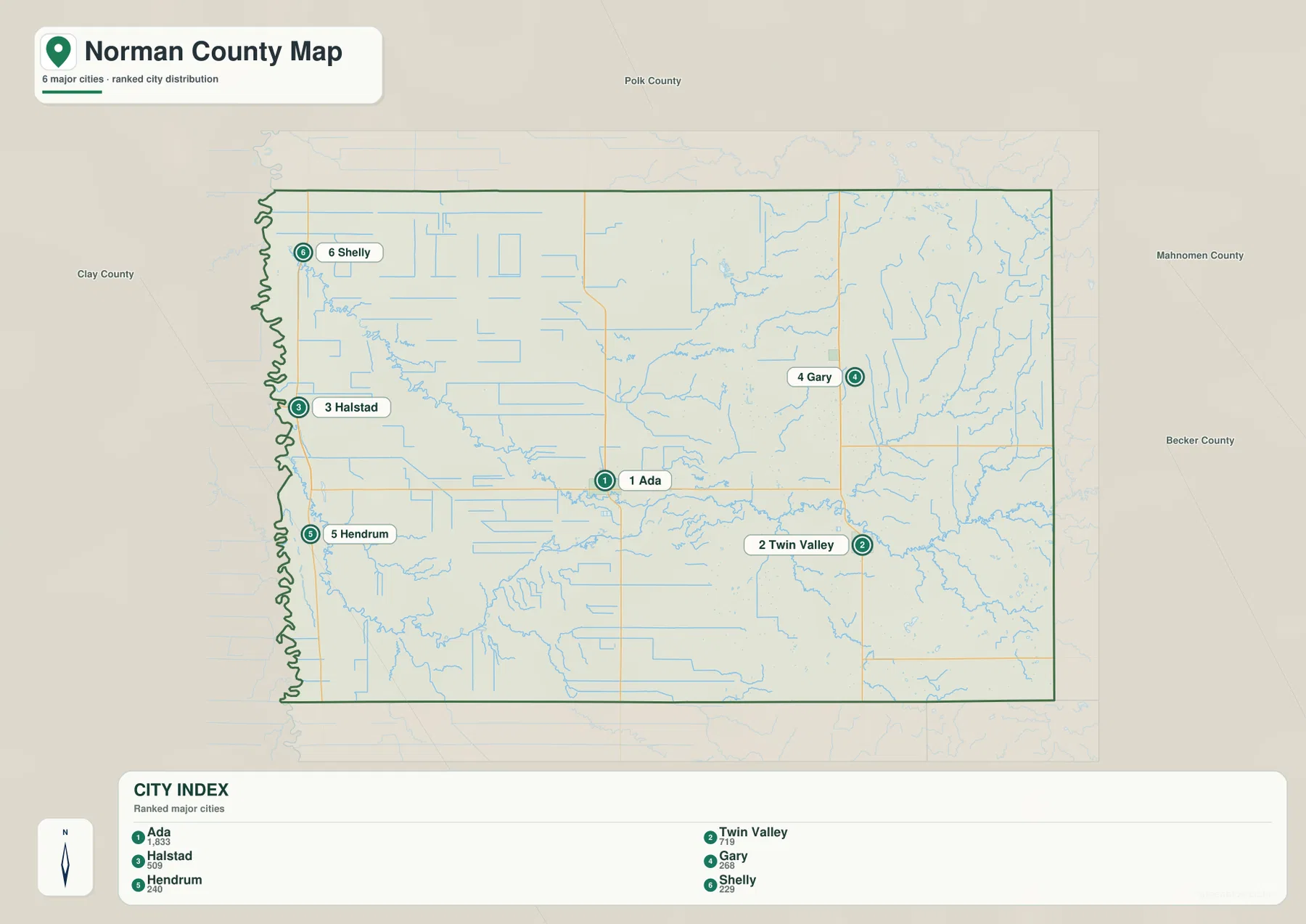
The map also shows Polk County to the north, Clay County to the west, and Mahnomen and Becker counties on the eastern side. Perley and Borup appear on the broader county map but are not part of the six-city index, so the ranked view should be treated as a simplified comparison rather than a complete municipal directory. For smaller places and highway detail, the county overview is the better companion map.
Marsh River, Wild Rice River, and a Dense Drainage Network
Two rivers dominate the water map: the Marsh River across the central part of the county and the Wild Rice River in the southwest. Both belong to the Red River basin and approach the low western side of Norman County. Minnesota DNR’s Red River water-trail information specifically notes the Wild Rice River entering the Red River near the Halstad area, which matches the strong river focus visible on the county maps.
The Wild Rice River has a labeled South Branch farther south, with Felton Creek nearby. Spring Creek and Coon Creek cross the central portion, while smaller named channels such as Mashaug Creek and Marsh Creek appear to the east. Girard Slough in the northeast adds a different kind of wetland feature to a map otherwise dominated by rivers, creeks, and man-made drainage lines.
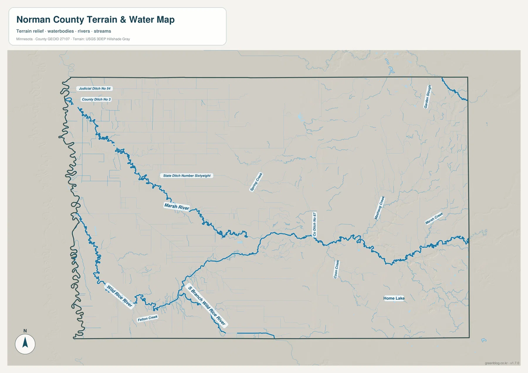
Those drainage lines are important in the western and central plain. Judicial Ditch No. 54, County Ditch No. 3, State Ditch Number Sixtyeight, and County Ditch No. 67 are all labeled, showing how much of the local water network includes constructed or managed channels as well as natural streams. Home Lake appears in the southeast, but large natural lakes are not the dominant feature of the county in the way rivers and ditches are.
This is a geographic water-reference map, not a floodplain, navigation, depth, drainage-rights, or property-boundary product. Anyone using the Red River or Wild Rice River should check current Minnesota DNR and local information for access, water levels, and safety instead of relying on the map alone.
Low Red River Plain Rising into the Eastern Uplands
The elevation map shows one of Norman County’s clearest physical patterns. Its legend gives an actual range of about 250 to 411 meters with a mean near 300 meters. The western half is mostly deep green, representing the low Red River plain, while the colors rise through lighter greens and yellows toward orange and brown in the east. The county therefore gains substantial elevation from west to east even though the western landscape looks extremely flat.
Ada sits near the broad transition between the lowest western plain and the rising eastern terrain. Moving toward Gary and Twin Valley, the surface becomes higher and more dissected. The eastern edge contains the strongest brown tones and more visible hills, while the Red River boundary remains consistently low. This contrast gives the county a clear physical division that mirrors the settlement pattern only partly: major communities exist on both the low plain and the higher east.
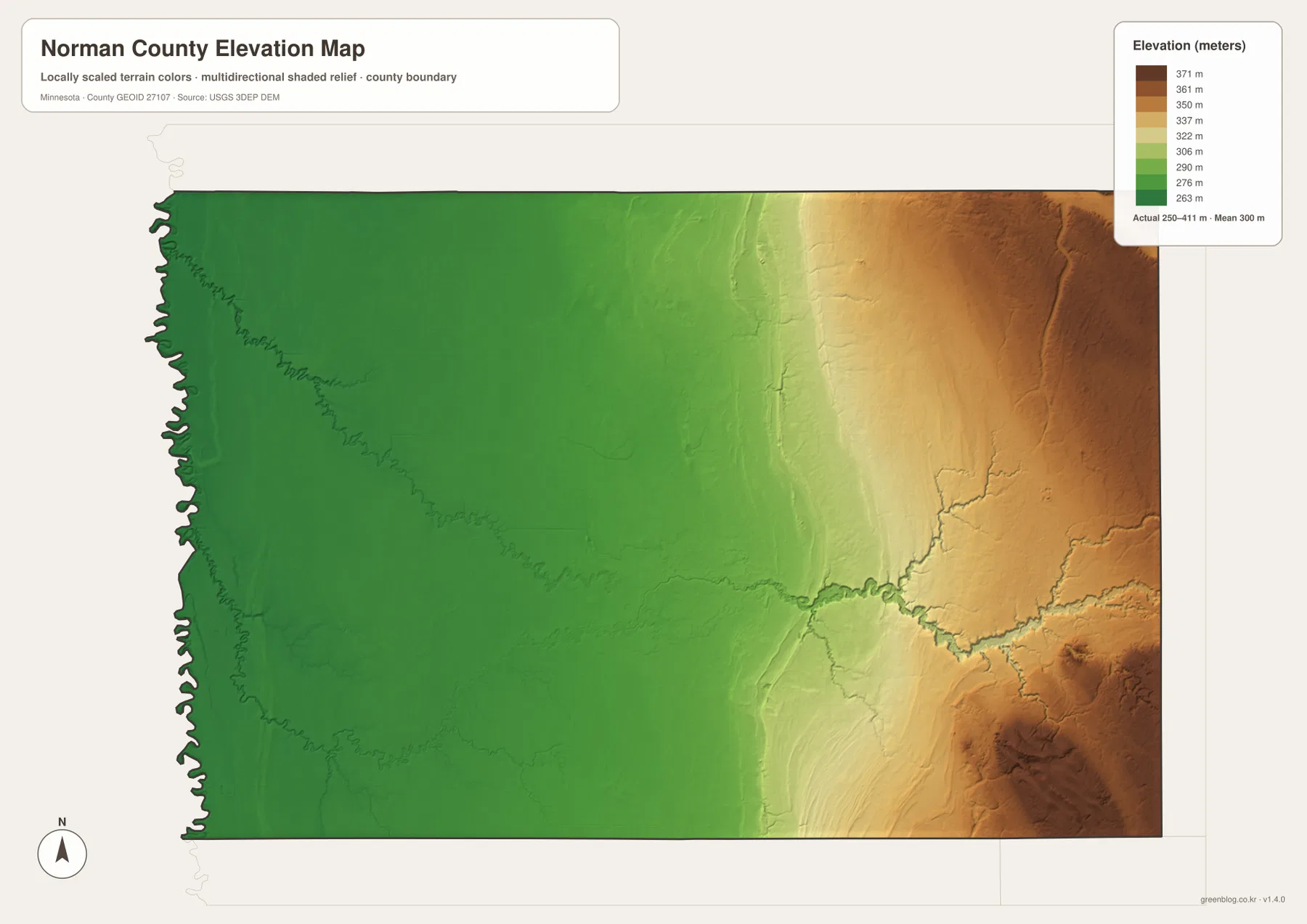
River valleys cut through that general rise. The Marsh River and smaller eastern streams create lower green and yellow corridors within terrain that would otherwise be higher. In the southeast, drainage lines also carve into the uplands. Comparing the water and elevation maps makes it easier to see that the east is not a single smooth plateau but a higher landscape crossed by numerous creek valleys.
The colors are locally scaled to emphasize differences inside Norman County, so the same shade on another county map may represent a different absolute elevation. The surface is intended for broad geographic interpretation rather than survey or engineering work. Construction, drainage design, and legal elevation decisions require more precise source data or field measurements.
Choosing the Best View for Roads, Rivers, and Relief
For roads and settlement orientation, begin with the county overview. It is the best place to locate Ada, the western Red River communities, and the eastern Gary–Twin Valley side while seeing the highways that connect them. The ranked city map is more efficient when the main question is simply how the six highlighted communities are distributed across the county.
For natural geography, trace the Marsh River and Wild Rice River toward the lower western plain, then compare the drainage ditches and smaller creeks across the interior. The elevation map explains the larger setting: low green terrain dominates the Red River side, while the east rises sharply into yellow, orange, and brown uplands. These two views together show why the county’s water network and relief look so different from one side to the other.
The WebP maps on the page are optimized for quick viewing. The downloadable ZIP contains the original high-resolution JPG versions of the county, city distribution, water, and elevation maps, each at 3638 by 2572 pixels. Those files are better for printing or zooming into small road numbers, creek names, and drainage labels than a screenshot of the browser page.
A practical reading order is to start on the Red River boundary near Shelly, Halstad, and Hendrum, move inland to Ada, and then continue toward Gary and Twin Valley in the east. After that, use the water and elevation maps to compare the Marsh and Wild Rice river systems with the rising eastern terrain. The sequence turns the county’s broad rural map into a simple pattern of low west, central Ada, and higher east.
Frequently Asked Questions
Which map is best for locating Ada and the Red River communities?
Use the county overview first. Ada is near the center, while Shelly, Halstad, and Hendrum sit close to the winding Red River boundary on the west. The ranked city map is a useful second view when you want to compare their relative positions with Gary and Twin Valley.
Where are the Marsh River and Wild Rice River shown?
The water map gives the clearest view. The Marsh River crosses the central part of Norman County, while the Wild Rice River curves through the southwest with a labeled South Branch nearby. Several creeks and drainage ditches are also shown, making the map useful for understanding the low western drainage network.
Which side of Norman County is highest?
The eastern side is much higher than the Red River plain in the west. The elevation legend shows an actual range of about 250–411 meters with a mean near 300 meters. The west is mostly deep green, while orange and brown high ground becomes common near the eastern boundary.
Map File Information
The ZIP contains the original high-resolution JPG versions of the Norman County overview, city distribution, water, and elevation maps.
- File Type: ZIP containing 4 JPG files
Related Maps
Sources and References
- Norman County official website – county government and local information
- Minnesota DNR Red River of the North segments and maps – Halstad and Wild Rice River corridor context
- U.S. Census Bureau TIGER/Line Shapefiles – county boundary and geographic reference data
- USGS National Hydrography – river and stream reference data
- USGS 3D Elevation Program – elevation reference data
Green Map creates custom-edited map images using open geographic data sources such as geoBoundaries, Natural Earth, OpenStreetMap, and government open data. These maps are edited visual materials, not raw data files, and are provided for education, documents, presentations, and graphic reference.