Mille Lacs County has one of the clearest north–south contrasts on the county maps in central Minnesota. The northern end is dominated by Mille Lacs Lake and the shore communities of Onamia, Wahkon, and Isle, while the long southern section narrows toward Milaca and Princeton. This page reads those two parts as one connected county, following the roads, the Rum River drainage, and the change in elevation from the higher north to the lower south. The on-page WebP maps provide quick reference, and the four matching high-resolution JPG originals are available together in a ZIP. High-resolution map files are available for download in the section below.
The county’s shape is the first clue to its geography. Its upper half is broad enough to wrap around a large part of Mille Lacs Lake, but the lower half becomes a much narrower north–south corridor. That means the northern lake communities and the southern U.S. 169 towns can feel like separate clusters even though they share the same county. Reading the map from the lake southward makes the road network and river pattern much easier to understand than starting with an isolated list of place names.
Table of Contents
Reading the Lake Shore and the U.S. 169 Corridor on One County Map
Mille Lacs Lake dominates the northern county overview. Vineland appears on the northwestern shore, Onamia is placed southwest of the lake, and Wahkon and Isle sit along the southern and eastern side. Minnesota 27 reaches Wahkon, while Minnesota 47 and Minnesota 18 provide key references around the Isle and northeastern area. Near Onamia, Minnesota 25 meets the north–south route that continues toward the long central section of the county.
The road pattern changes farther south. U.S. 169 becomes the most obvious longitudinal route, connecting the Milaca area with Princeton near the southern boundary. Around Milaca, Minnesota 23 and Minnesota 36 create east–west crossings, and Minnesota 16 is shown on the route leading north toward the central county. The distance between Princeton and the Mille Lacs Lake shore is visually significant, which helps explain why the county contains more than one practical orientation center.
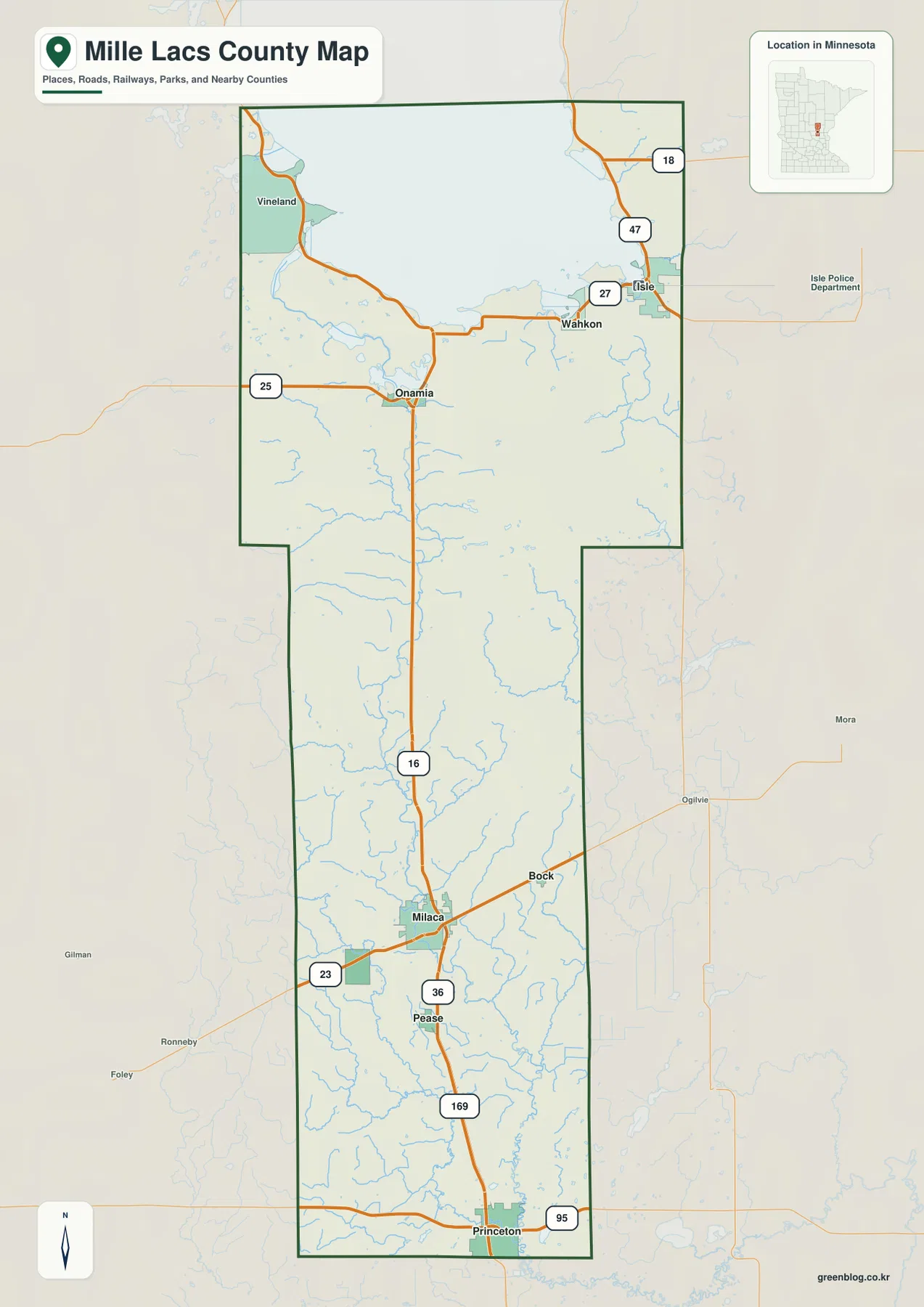
The broader map also gives useful regional context. Places such as Mora and Ogilvie are labeled to the east, while Gilman and Foley appear to the west. Those references make it easier to see which side of the county a road continues toward after crossing the boundary. The map is designed for geographic orientation and route context, however, not for parcel ownership, zoning, surveying, or other legal land-boundary decisions.
A Split Settlement Pattern from Princeton and Milaca to the Lake Shore
The ranked city distribution map highlights six major communities. Its index lists Princeton at 5,274, Milaca at 3,044, Foreston at 757, Onamia at 719, Isle at 695, and Wahkon at 258. The two largest entries are both in the southern half, while three of the smaller communities are tied directly to the Mille Lacs Lake area in the north. These figures are best read as the city index supplied with the map; anyone needing a current official population estimate should verify it with the latest Census release.
Princeton sits at the far southern end of the highlighted distribution, with Milaca to the north and Foreston slightly west of the main north–south corridor. Onamia is much farther north near the lake, while Wahkon and Isle form a small eastern lake-shore cluster. This separation matters more than the rank alone because it shows why a trip between two Mille Lacs County towns may cross a large portion of the county despite both places appearing in the same six-city index.
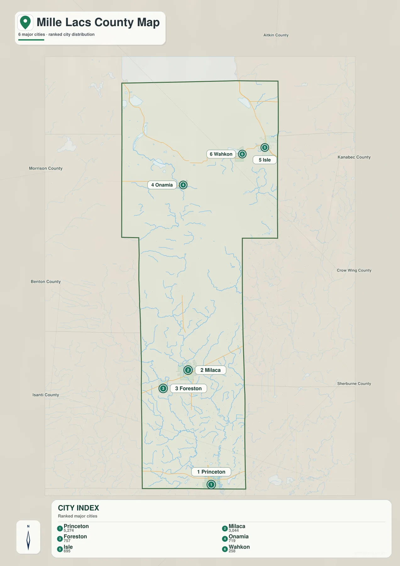
The city map also shows the surrounding county directions. Aitkin County is north, Kanabec County and Crow Wing County are east, Sherburne County lies to the southeast, Morrison and Benton counties are to the west, and Isanti County appears southwest of the southern section. That context makes the edge positions clearer: Princeton is close to the southern boundary, while Isle and Wahkon sit near the eastern side of the broad northern section.
From Mille Lacs Lake into the Long Rum River Drainage
The water map makes clear that Mille Lacs Lake is not simply a large blue shape at the top of the county. Wigwam Bay, Sunset Bay, and Wahkon Bay define different shore areas, while Ogechie Lake, Shakopee Lake, and Lake Onamia form a smaller lake group immediately south and southwest of the main lake. The concentration of named water features gives the northern county a very different character from the narrower southern corridor.
The Rum River is the key connection between those two landscapes. It is shown beginning near the Lake Onamia area and running south through the center of the county for a long distance. In the southern section, the W Branch Rum River appears as a separate tributary before joining the broader drainage. The river’s long path makes it one of the most useful natural reference lines for understanding how the northern lake country relates to the Milaca and Princeton side of the county.
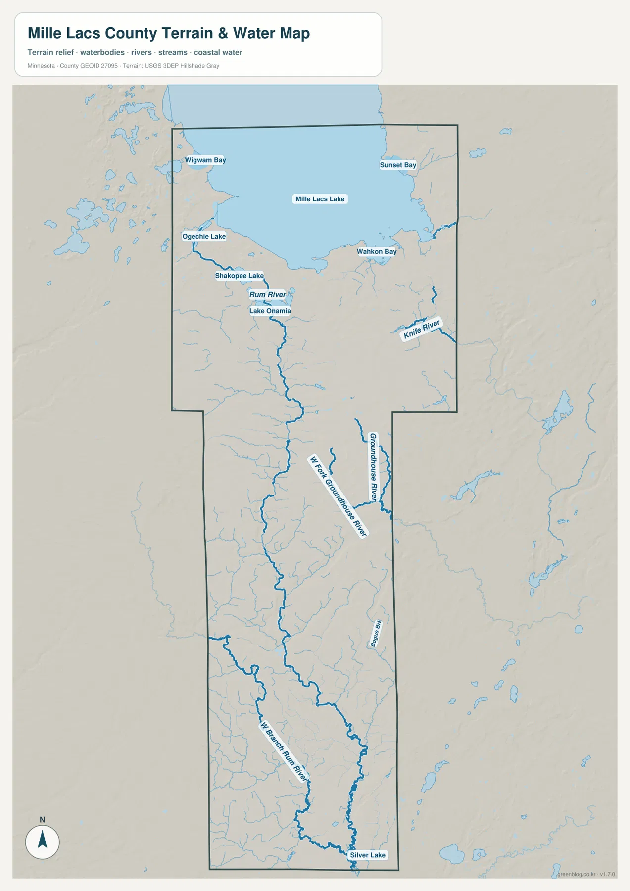
Other drainages create a more complicated eastern network. The Knife River is labeled in the northeast and east, while the Groundhouse River and W Fork Groundhouse River appear farther south along the eastern side. Bogus Brook is also marked in the south-central portion, and Silver Lake appears near the county’s southern end. Together, these features show that the county’s water does not belong to one simple single-channel system.
This map is intended for geographic reference rather than water-use decisions. It does not show flood zones, depth, navigability, public boat access, shoreline ownership, or current fishing rules. For recreation on Mille Lacs Lake, the Rum River, or smaller lakes and streams, current Minnesota DNR and local information should be checked before relying on the map for access or regulatory questions.
Higher Northern Ground Falling toward the Princeton Lowlands
The elevation map shows a broad decline from north to south. Its legend gives an actual elevation range of about 290 to 416 meters with a mean near 360 meters. Much of the northern county is shown in brown and orange, while yellow and green become more common farther south. Near Princeton, darker greens cover a large area, making the lower southern terrain easy to distinguish from the higher northern land.
The transition is gradual rather than a single steep drop. Across the middle of the county, small ridges and valleys interrupt the overall north–south trend, and a lower corridor associated with the Rum River becomes visible. When this shaded-relief view is compared with the water map, the river can be understood as part of a long low route through the county rather than merely a line drawn over otherwise uniform terrain.
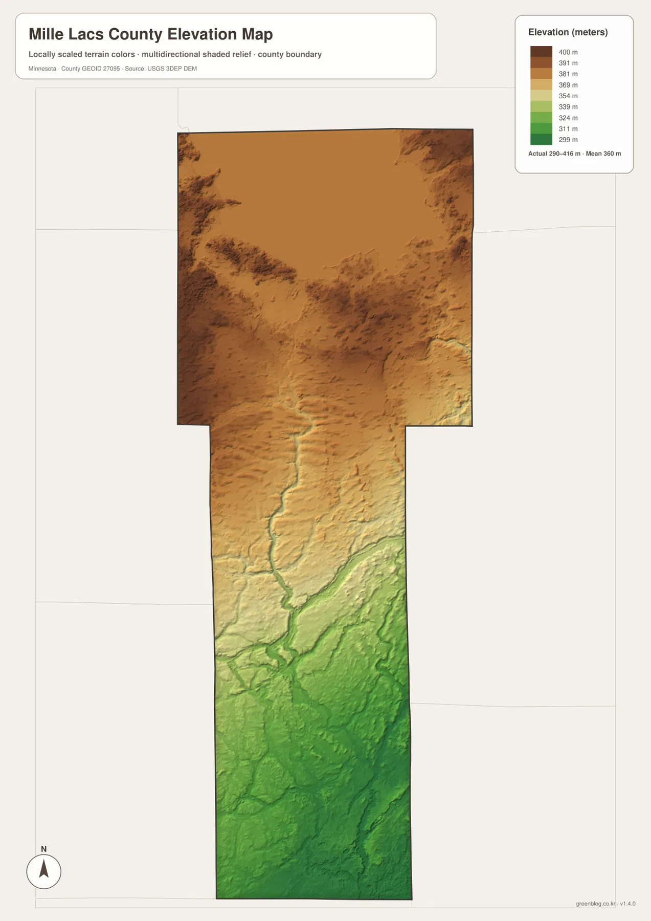
The local color scale is designed to emphasize differences within Mille Lacs County. A brown or green shade on another county map may correspond to a different absolute elevation, so color alone should not be used for cross-county measurement. The shaded surface is also generalized for visual interpretation. Construction, engineering, drainage design, and legal elevation questions require survey-grade or site-specific elevation information.
Choosing between the Road, City, Water, and Relief Views
For a first pass, the county overview is best for understanding roads and settlement position. It shows the northern lake-shore roads around Onamia, Wahkon, and Isle and then lets the reader follow the long corridor south toward Milaca and Princeton. The city distribution map is more efficient when the goal is to compare the six highlighted communities without the full road network.
The water map is the strongest choice when Mille Lacs Lake and the Rum River are the subject. Ogechie Lake, Shakopee Lake, Lake Onamia, Wahkon Bay, and the river corridor provide much more natural-landmark detail than the general county map. The Groundhouse and Knife river systems also help separate eastern drainage features from the main Rum River route.
The elevation map answers a different question: how the higher northern terrain changes into the lower southern section. It is especially useful beside the water map because the Rum River corridor and several low drainage areas become easier to recognize. The county’s elongated outline makes this comparison unusually clear, with lake country, river corridor, and lower southern terrain arranged almost as successive zones.
The WebP images on the page are optimized for quick viewing, while the downloadable ZIP contains the four original high-resolution JPG maps. Each JPG is 2572 by 3638 pixels, so smaller road numbers, river labels, and town names can be inspected more closely than in a browser screenshot. For printing or use in a separate document, the original JPG is the better source.
A practical way to read all four maps together is to begin at Mille Lacs Lake, identify Onamia, Wahkon, and Isle, then trace the Rum River south through the long middle section. From there, locate Milaca and Princeton along the U.S. 169 corridor and finish with the elevation map to see the shift from higher northern ground to lower southern terrain. That sequence turns what first looks like an unusually shaped county into a coherent geographic pattern.
Frequently Asked Questions
Which map is best for understanding Mille Lacs Lake and the nearby towns?
Use the county overview together with the water map. The county overview places Onamia southwest of the lake and Wahkon plus Isle along the southeastern and eastern side, while the water map adds Wahkon Bay, Sunset Bay, Ogechie Lake, Shakopee Lake, and Lake Onamia. The first map is better for roads; the second is better for the shoreline and connected water features.
How does the Rum River run through Mille Lacs County?
On the water map, the Rum River begins near the Lake Onamia area south of Mille Lacs Lake and then runs for a long distance toward the southern part of the county. A W Branch Rum River is also labeled in the south. Comparing the river with the elevation map shows that much of its course follows a lower corridor within the county’s general north-to-south decline.
What is the main elevation pattern in Mille Lacs County?
The broad pattern is higher terrain in the north and lower terrain in the south. The map legend gives an actual range of roughly 290–416 meters and a mean near 360 meters. Northern areas are mostly brown and orange, while the Princeton side of the county is much greener. The colors are locally scaled and should not be treated as survey-grade elevation measurements.
Map File Information
The ZIP contains the original high-resolution JPG versions of the Mille Lacs County overview, city distribution, water, and elevation maps.
- File Type: ZIP containing 4 JPG files
Related Maps
Sources and References
- Mille Lacs County GIS Services – official county GIS services and spatial reference information
- U.S. Census Bureau TIGER/Line Shapefiles – county boundary and geographic reference data
- USGS National Hydrography – river, stream, and lake reference data
- USGS 3D Elevation Program – elevation reference data
Green Map creates custom-edited map images using open geographic data sources such as geoBoundaries, Natural Earth, OpenStreetMap, and government open data. These maps are edited visual materials, not raw data files, and are provided for education, documents, presentations, and graphic reference.