Martin County sits along Minnesota’s southern edge at the Iowa line, with Fairmont as the most prominent city on the maps and a network of smaller communities spread across the county. This page brings the county boundary, roads, settlement pattern, lakes and streams, and elevation into one practical guide. The on-page WebP maps are useful for quick reference, and the matching high-resolution JPG map files can be downloaded together in a ZIP for printing or personal projects.
A simple way to orient yourself is to begin with Fairmont and Interstate 90. I-90 crosses the middle of the county from west to east, linking the Sherburn and Welcome side of the county with Fairmont and the eastern area. Truman sits well to the north, Trimont is toward the northwest, and Ceylon lies near the southern side. Those reference points make the county easier to understand before you look at individual lakes, streams, or elevation changes.
Table of Contents
Finding Fairmont and I-90 along the Iowa Border
The county map combines the outer Martin County boundary with towns, major roads, rail lines, parks, and nearby counties. Watonwan County and Blue Earth County are north of Martin County, Jackson County and Cottonwood County are to the west and northwest, and Faribault County is on the east. The southern edge is the Minnesota–Iowa state line. Seeing that state boundary is especially helpful because travel south from many parts of the county quickly becomes interstate rather than simply movement into another Minnesota county.
I-90 is the clearest east–west road on the map. It passes the Sherburn and Welcome area and continues through the Fairmont side of the county. Minnesota Highway 15 gives Fairmont a strong north–south reference and continues toward Northrop and Truman. Other labeled places, including Trimont, Granada, and Dunnell, help fill in the spaces between the larger communities and show that Martin County is not organized around one continuous urban strip.
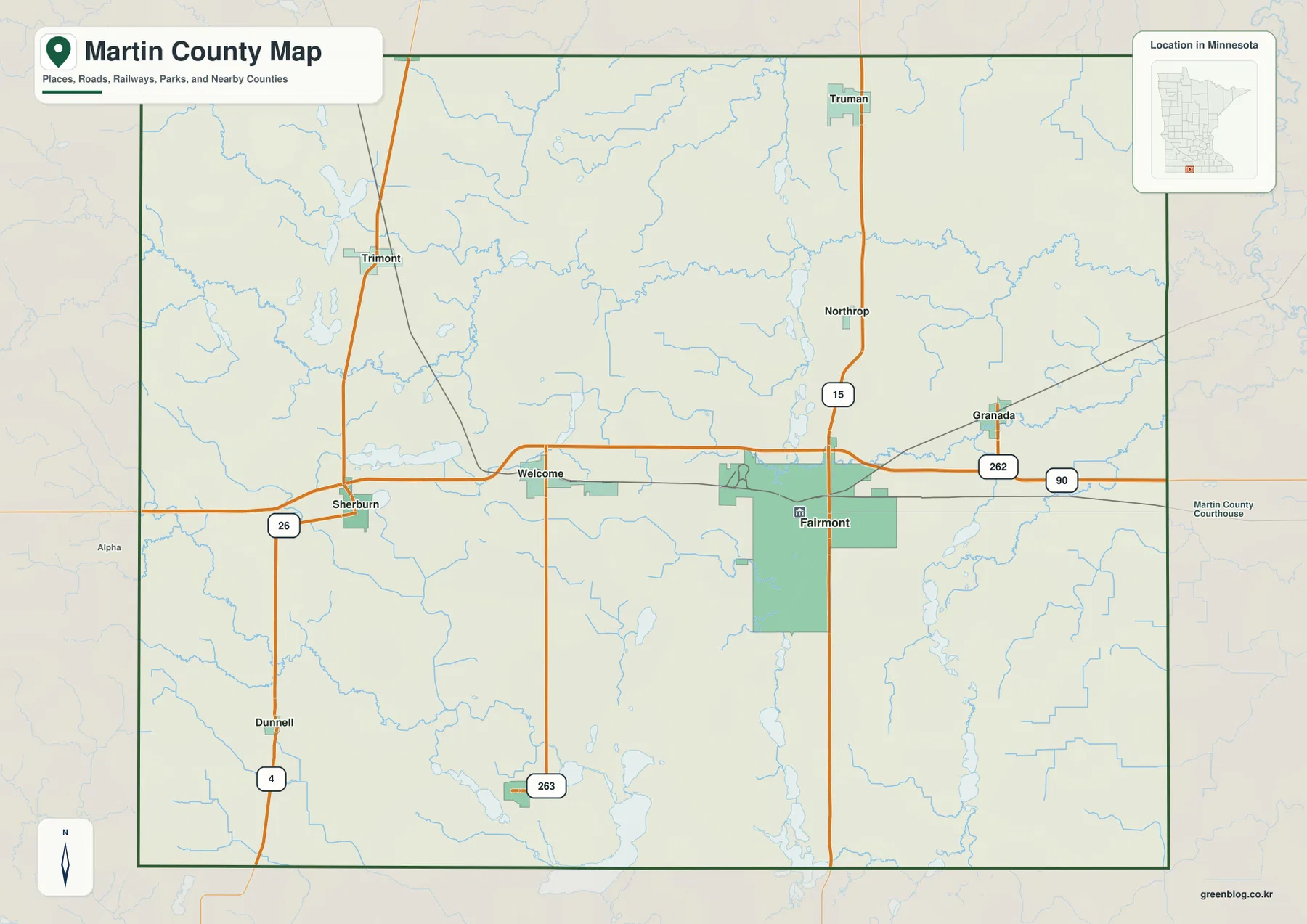
Fairmont has the broadest shaded urban footprint on this map, while towns such as Truman, Sherburn, and Welcome appear as smaller built-up areas. That visual contrast is useful when comparing the location and relative footprint of settlements at this map scale. It should not be treated as a parcel map or a legal land-boundary source, however. Property, survey, or zoning questions require the appropriate county or state records.
How the Major Communities Spread out from Fairmont
The city distribution map focuses on six major communities: Fairmont, Truman, Sherburn, Welcome, Trimont, and Ceylon. Fairmont is positioned in the eastern half of the county, with Welcome and Sherburn extending westward along the I-90 corridor. Trimont is farther northwest, while Truman is separated to the north. This arrangement shows why Fairmont works well as a reference point without implying that every major community is clustered immediately around it.
Ceylon is the southernmost of the six highlighted communities and sits much closer to the Iowa side of the county than Truman does. That north–south contrast is useful for planning a basic route, explaining county geography in a classroom, or simply understanding why two Martin County towns may be farther apart than a small-scale state map suggests. The map is meant for relative location, not turn-by-turn navigation.
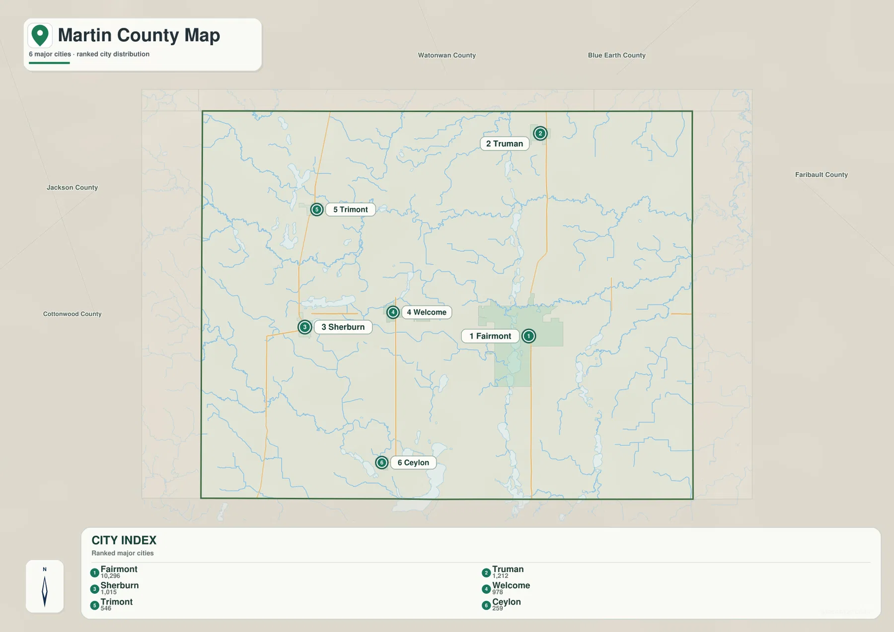
Granada and Northrop appear on the broader county map even though they are not among the six ranked locations on the city distribution map. For that reason, this city view should be read as a simplified comparison of major population centers rather than a complete municipal directory. Use it when the goal is to see the overall settlement pattern quickly, then return to the county map for a wider set of place names and road connections.
Lakes and Creeks from Cedar Lake to the East Fork Des Moines River
The terrain and water map shows a different side of Martin County. Cedar Lake and Cedar Run are labeled in the northwest, with Big Twin Lake and Fox Lake farther south in the western half. Across the center and east, named streams such as Lily Creek, Elm Creek, Center Creek, and South Creek form a network of smaller waterways. The map makes clear that lakes and streams are distributed across the county rather than concentrated in only one corner.
Around Fairmont and south of the city, Buffalo Lake and Hall Lake stand out. East Chain Lake forms a long water feature in the southeast, while Iowa Lake and Clayton Lake appear closer to the southern border. The East Fork Des Moines River is also labeled in the southern part of the county. Comparing these features with the county map helps connect natural landmarks to the nearby towns and road system instead of treating the water features as isolated names.
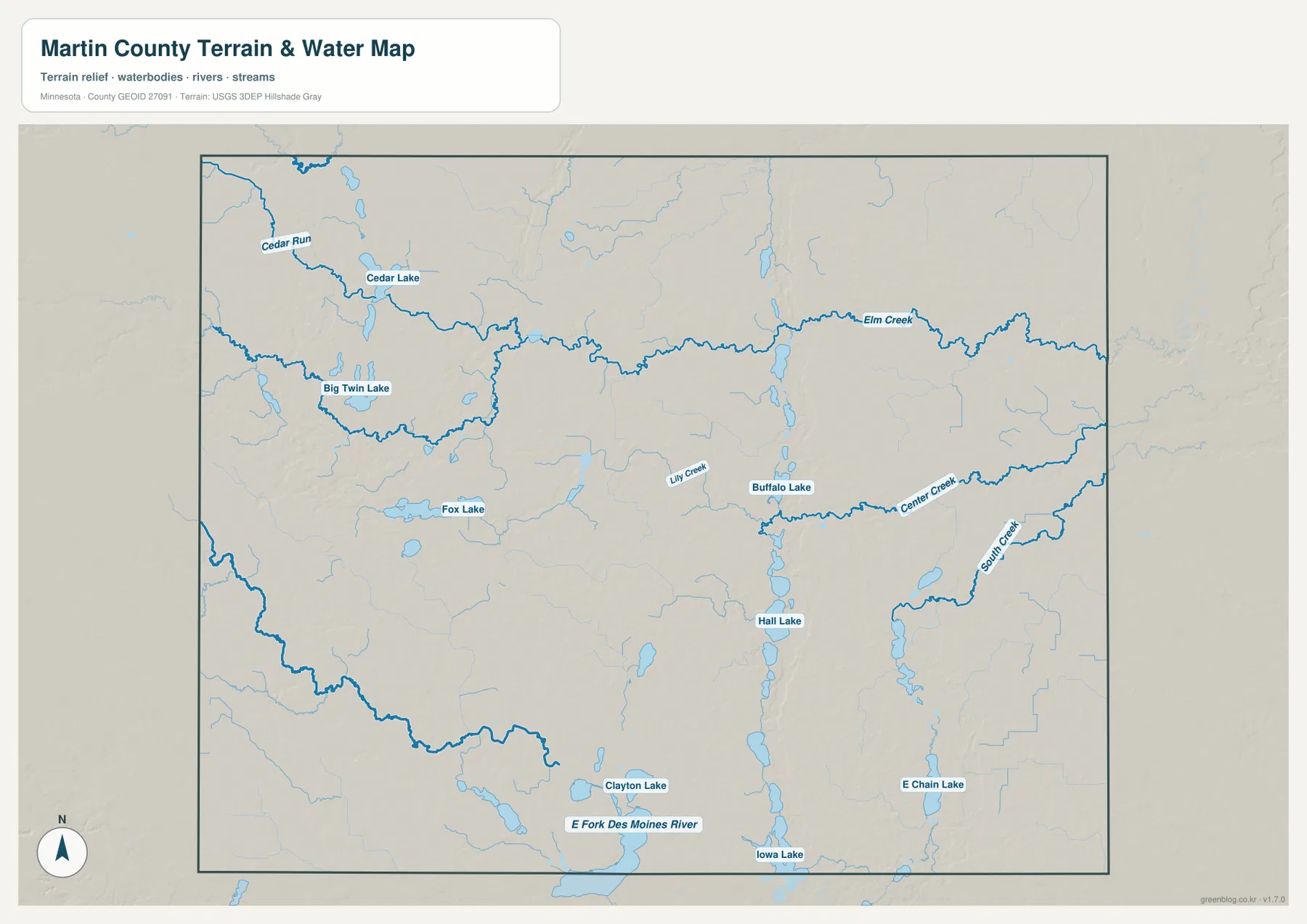
This is a water-reference and terrain map, not a floodplain, navigation, depth, or property-boundary map. A stream shown here should not be used by itself to determine flood risk or legal access, and a lake label does not establish where public entry is available. Minnesota DNR and local agencies are better sources for current fishing regulations, boat access, water conditions, and recreation rules.
A Gentle Drop in Elevation from West to East
The elevation map has a strong west-to-east contrast. Its legend shows an actual elevation range of roughly 321 to 430 meters, with a mean near 367 meters. Browns and oranges dominate much of the west and southwest, indicating the higher side of the county, while greens spread across the east where elevations are generally lower. The change is broad enough to be visible at county scale without suggesting a mountainous landscape.
Martin County is still a gently rolling part of southern Minnesota. The shaded relief shows low ridges, shallow depressions, and subtle drainage corridors rather than steep peaks or canyons. When the elevation map is compared with the water map, some of the elongated lower areas help explain where streams and lake chains fit into the surrounding ground. That combined view is more informative than looking at elevation colors alone.
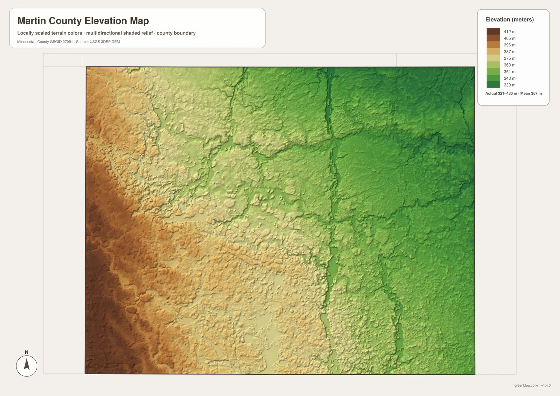
The elevation colors are locally scaled to show variation within Martin County, so they should not be compared directly with colors on another county map as if the same shade always represented the same height. The surface is a generalized representation based on elevation data and is not survey-grade information. Engineering, drainage design, construction, and legal elevation questions require more precise site-specific measurements.
Choosing the Right Martin County Map for the Task
Choosing among the maps is easier when the task is clear. The county map is the best starting point for boundaries, roads, surrounding counties, and a broad set of town names. The city distribution map works better when the main question is where Fairmont, Truman, Sherburn, Welcome, Trimont, and Ceylon sit in relation to one another. The water map adds the named lakes and creeks that are easy to miss on a road-focused view.
The elevation map is most useful when you want to explain why the western side of the county appears higher and how that broad difference relates to lower areas farther east. The four maps are complementary rather than interchangeable. A classroom handout might use one clean map, while a local-history or travel presentation could place two or more maps side by side to connect settlements, waterways, and relief.
The WebP images on the page are optimized for quick viewing. The ZIP provides the corresponding high-resolution JPG originals, each at 3638 by 2572 pixels, which is preferable for printing or close inspection of labels. If a town, creek name, or road number looks small in the browser, open the downloaded JPG and zoom into the original rather than relying on a screenshot of the page.
Reading the State Line, Towns, Water, and Relief Together
Martin County’s state-line position changes the way neighboring areas should be read. To the north, east, and west, the county connects with other Minnesota counties, while the entire southern side meets Iowa. A route that looks like a short southward extension on a county map may therefore cross a state boundary. Keeping that in mind helps when comparing road networks, nearby towns, or public-agency information.
Fairmont and I-90 make a practical orientation pair. From Fairmont, Welcome and Sherburn are to the west, Granada is to the east, Truman is to the north, and Ceylon is to the south. This relative framework is easier to remember than a list of highway numbers and gives first-time readers a dependable mental map of the county before they study smaller features.
Water adds another layer to that framework. Cedar Lake and Fox Lake mark the western side, the Fairmont-area lakes create a noticeable cluster near the county’s main city, and Iowa Lake plus the East Fork Des Moines River help define the southern landscape. Add the higher western ground and lower eastern terrain, and the county becomes easier to understand as one connected system of towns, routes, water, and relief.
Frequently Asked Questions
Which map is best for finding Fairmont and Interstate 90?
Start with the county map. It shows Fairmont’s urban area, the east–west path of I-90, and nearby communities such as Welcome, Sherburn, and Granada on the same view. If you only need a quick comparison among the six highlighted population centers, the city distribution map provides a simpler layout.
Where are the main lakes shown in Martin County?
The water map shows lakes in several parts of the county. Cedar Lake and Fox Lake are in the western half, Buffalo Lake and Hall Lake are near the Fairmont area, and East Chain Lake and Iowa Lake appear farther south and southeast. For actual boating, fishing, or public-access information, check current Minnesota DNR resources rather than relying on this reference map alone.
Why does the western side look darker on the elevation map?
The darker brown and orange colors represent relatively higher ground within Martin County. The map legend gives an actual range of about 321 to 430 meters, and the eastern side is generally lower and greener. The map is intended for broad geographic comparison, not for engineering, surveying, or site-level elevation decisions.
Map File Information
The ZIP contains the original high-resolution JPG versions of the Martin County overview, city distribution, water, and elevation maps.
- File Type: ZIP containing 4 JPG files
Related Maps
Sources and References
- Martin County official website – county and local government information
- U.S. Census Bureau TIGER/Line Shapefiles – county boundary and geographic reference data
- Minnesota DNR Windom Area Fisheries – regional water information including Martin County and the Fairmont Chain of Lakes
- USGS National Hydrography – hydrography reference data
- USGS 3D Elevation Program – elevation reference data
Green Map creates custom-edited map images using open geographic data sources such as geoBoundaries, Natural Earth, OpenStreetMap, and government open data. These maps are edited visual materials, not raw data files, and are provided for education, documents, presentations, and graphic reference.