Marshall County stretches across northwestern Minnesota from the Red River lowlands to a wetter and somewhat higher eastern landscape. Warren, Stephen, Argyle, Newfolden, Middle River, and Alvarado provide useful town references, while the county’s rivers, managed wetlands, and terrain explain why the eastern and western halves look so different. The high-resolution A3 JPG maps used on this page can also be downloaded together in one ZIP file. High-resolution map files are available for download in the section below.
The western boundary follows the winding Red River of the North along the North Dakota state line. Most of the prominent towns shown on the map lie in the western and central sections, but the eastern side is dominated by large wetland complexes around Agassiz National Wildlife Refuge and Thief Lake. Looking at roads, water, and elevation together makes the county much easier to understand than using a town list alone.
Table of Contents
Warren anchors a long county on Minnesota’s northwest edge
Marshall County occupies a broad strip of northwestern Minnesota, with North Dakota immediately across the Red River. U.S. Census Bureau QuickFacts reports 9,040 residents in the 2020 Census and a July 1, 2025 estimate of 8,798. Its 2010 land area was about 1,775.07 square miles, so the county combines a small population with a large rural area and substantial distances between communities.
Warren is the county seat and the first town to use as an orientation point. Stephen lies to the northwest, Argyle is between Warren and Stephen, and Alvarado sits close to the southwestern edge. Newfolden and Middle River shift the pattern farther east and north, showing that settlement is not limited to the immediate Red River corridor even though the western side has the clearest concentration of towns.
The surrounding county names help place Marshall County within the region. Kittson and Roseau counties are to the north, Beltrami and Clearwater counties are to the east, while Pennington and Red Lake counties appear to the south. Across the western border is North Dakota, making Marshall County part of a wider Red River Valley region rather than an isolated corner of Minnesota.
Roads connect the Red River side with the wetland interior
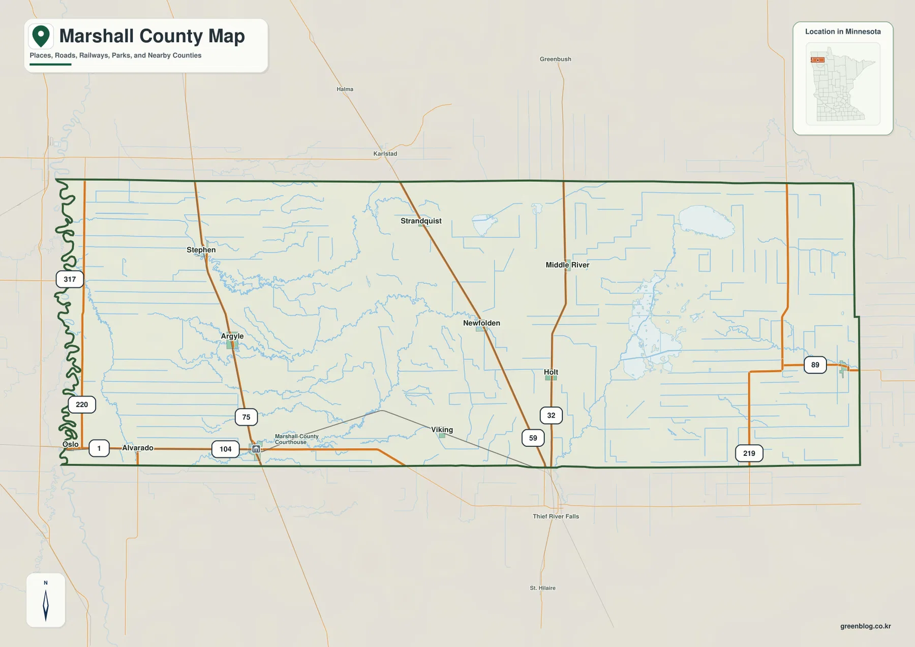
U.S. 59 is one of the easiest routes to follow on the county map. It enters from the south, passes east of Warren, and continues north through the central part of the county near Newfolden. Minnesota 1 runs east-west across the southern side near Alvarado and Warren, while routes 220 and 317 stay much closer to the Red River boundary.
Farther east, Minnesota 32 and Minnesota 89 become useful reference lines. Route 32 runs south from the Middle River area, and 89 crosses the eastern part of the county. Routes 104 and 219 also appear in the south. Together these roads show why a trip across Marshall County can feel very different depending on direction: the west has a more regular rural road grid, while the wetland-rich east has fewer direct connections.
The county map also labels places outside the boundary, including Oslo, Karlstad, Greenbush, and Thief River Falls. These are useful orientation points without being part of Marshall County itself. When planning a route, it is worth checking both the county boundary and the road number rather than relying on the nearest town name alone.
Six towns make the settlement pattern easy to compare
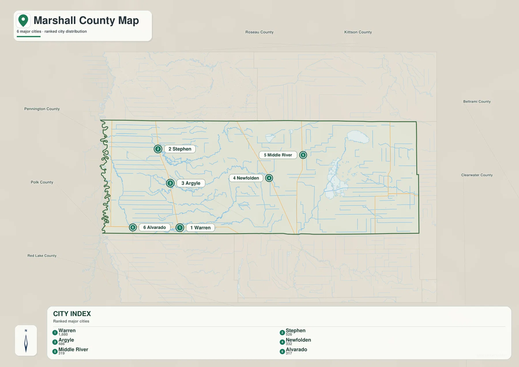
The city map gives six communities a clearer visual hierarchy: Warren, Stephen, Argyle, Newfolden, Middle River, and Alvarado. Warren appears in the southwest-central part of the county, with Alvarado closer to the Red River. Argyle and Stephen form a northward sequence, while Newfolden and Middle River move the pattern toward the central and northeastern sections.
The map includes a ranked city index, but the spatial relationship is more useful than the ranking for most readers. Warren is the largest reference point on the map, yet the county covers enough territory that Middle River and Stephen can be far apart even though both are in the same county. The simplified view helps explain that separation without asking the reader to sort through dozens of local road labels.
Neighboring counties are printed around the map frame, including Roseau, Kittson, Beltrami, Clearwater, Pennington, Polk, and Red Lake. This wider context is especially helpful for readers approaching from outside the region. It shows why Warren and Alvarado are convenient references for the Red River side, while Middle River is better for describing access toward the eastern wetlands.
Tamarac, Middle, and Snake rivers lead toward the Agassiz wetlands
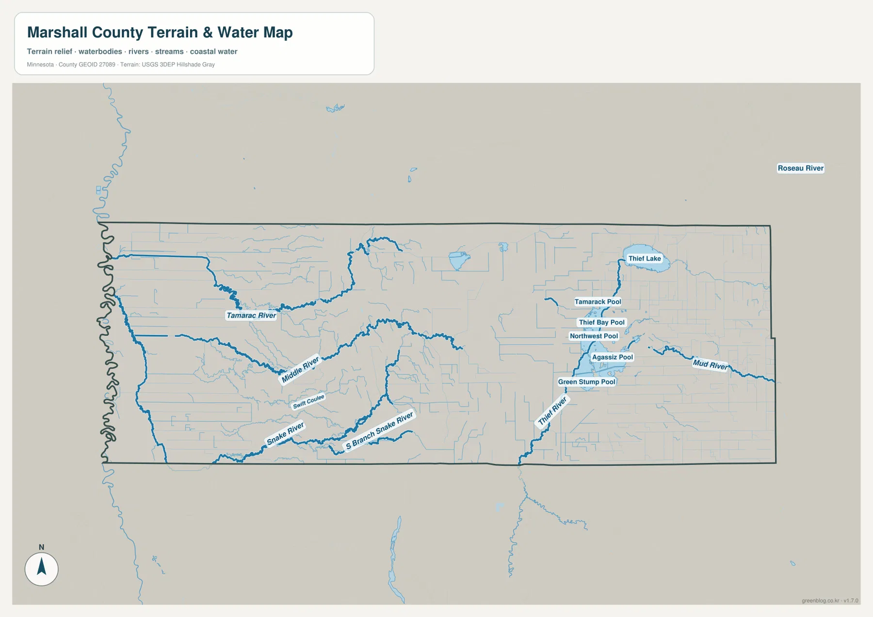
The water map brings forward features that are easy to miss on a road-focused view. Tamarac River crosses the northwestern and central portion of the county, while Middle River runs farther south. Snake River and South Branch Snake River trace the southern part of the county, and Swift Coulee appears as a smaller drainage feature between them.
The eastern half is visually different because managed wetlands and large water areas become much more prominent. Agassiz Pool, Northwest Pool, Thief Bay Pool, Tamarack Pool, and Green Stump Pool are labeled within the Agassiz National Wildlife Refuge area. The U.S. Fish and Wildlife Service says the refuge was established in 1937 and now encompasses about 61,500 acres of wetland and upland habitat, including numerous managed wetland impoundments.
Thief Lake appears north of the refuge complex, with Thief River running south from the lake. Mud River is labeled on the eastern side as well. Minnesota DNR describes the broader Thief Lake Wildlife Management Area as a major wetland and wildlife management landscape, so the lake should be understood as part of a much larger habitat network rather than as a single isolated water body.
This reference map is useful for locating rivers, lakes, and managed pools, but it is not a flood map, navigation chart, parcel map, or statement of current access conditions. Refuge and wildlife-management rules can change, and some water areas have special restrictions. Anyone planning hunting, fishing, boating, or a visit should check the current agency information rather than using this graphic as an operational guide.
Elevation rises away from the Red River
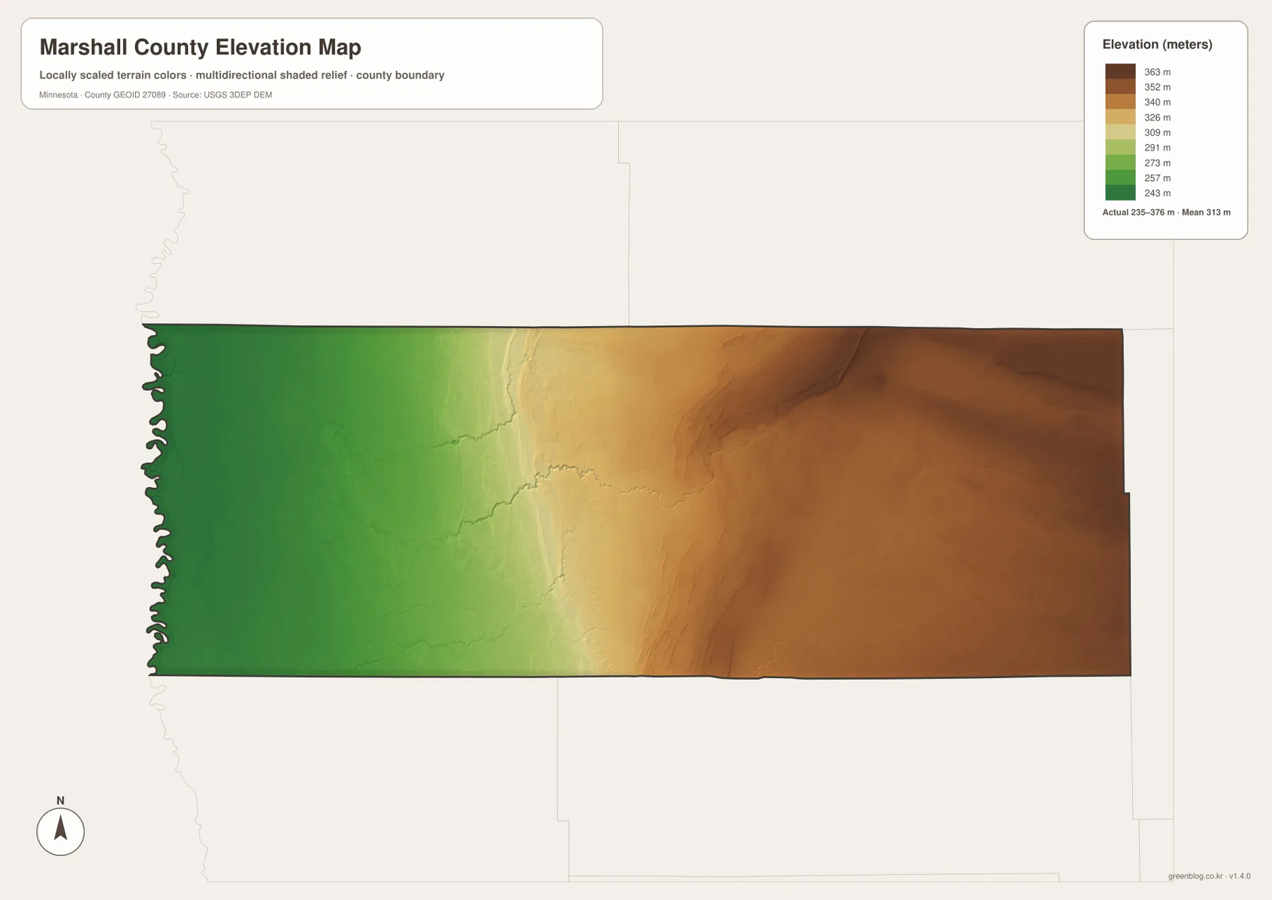
The elevation map makes the county’s broad west-to-east change immediately visible. Its legend gives an actual range of about 235 to 376 meters, with a mean near 313 meters. The Red River side is shown in darker green, representing the lowest part of the county, while the colors move through lighter green and yellow before reaching broad brown areas in the east.
This pattern fits the county’s position on the edge of the Red River Valley. The western side is notably flat and low, and the ground rises gradually toward the interior. The map does not show mountains or steep alpine relief; instead, it highlights a regional elevation difference spread across many miles. That gradual rise helps explain why the west feels more like open lowland while the eastern side has a different terrain character around the wetland country.
The color scale is local to Marshall County, so colors should not be compared directly with another county’s elevation map. A brown area here may represent a very different absolute height from a brown area elsewhere. For cross-county comparisons, use the numeric legend, and for engineering, surveying, or exact spot elevations, consult USGS 3D Elevation Program data rather than a generalized county image.
Which file works best for your purpose?
For general location checks, the county reference map is the best starting point because it combines towns, roads, the county boundary, and nearby places. The city map is more useful when the goal is simply to explain where Warren, Stephen, Argyle, Newfolden, Middle River, and Alvarado sit relative to one another. It removes much of the smaller road detail and works well in introductory slides or classroom material.
The water file is the better choice for the Tamarac, Middle, and Snake rivers, Thief Lake, and the managed pools inside the Agassiz wetland complex. The elevation file answers a different question by showing where the county is lower or higher. Pairing the water and elevation maps can be particularly useful when explaining why eastern Marshall County looks so different from the flatter Red River side.
Each supplied file is a high-resolution A3 JPG, so it can be printed at a useful size or reduced for a report, worksheet, or presentation. Instead of placing every layer on one crowded graphic, choose the map that matches the subject: roads and towns for orientation, water for rivers and wetlands, or elevation for relief.
Important limits before using the maps
These graphics are general county-reference maps. They are not legal boundary surveys, property maps, emergency-routing products, flood-hazard maps, or authoritative navigation charts. That distinction matters in and around Agassiz National Wildlife Refuge and Thief Lake Wildlife Management Area, where access and activity rules may apply. Current agency information should always take priority for real-world decisions.
The city index is best treated as a visual comparison supplied with the map rather than as a substitute for a current population database. The elevation image is also a generalized surface designed to show broad county differences, not a point-by-point survey. Used within those limits, the four files complement one another and provide a clear picture of settlement, transportation, water, and terrain across Marshall County.
Frequently Asked Questions
Which map is easiest for locating Warren, Stephen, and Argyle?
The city map is the quickest option because it gives Warren, Stephen, Argyle, Newfolden, Middle River, and Alvarado prominent labels. Use the full county map next when you need highway numbers, smaller places, or the county boundary.
Where are Agassiz National Wildlife Refuge and Thief Lake easiest to see?
The water map shows them most clearly. It labels Thief Lake and Thief River along with Agassiz Pool, Northwest Pool, Thief Bay Pool, Tamarack Pool, Green Stump Pool, and nearby river corridors.
Why is western Marshall County green on the elevation map?
The western side near the Red River is the lowest part of the county, while elevations generally rise toward the east. The colors are locally scaled, so use the numeric meter values rather than matching colors with another county map.
Map File Information
The Marshall County download includes the county reference map, city map, water map, and elevation map as high-resolution A3 JPG files.
- Included Files: County map, city map, water map, elevation map
- Printable Size: High-resolution A3
- File Type: JPG
Related Maps
Sources and reference data
- U.S. Census Bureau QuickFacts – Marshall County, Minnesota for population and land-area statistics.
- U.S. Fish & Wildlife Service – Agassiz National Wildlife Refuge for refuge size, wetlands, and wildlife information.
- Minnesota DNR – Thief Lake Wildlife Management Area for the Thief Lake wetland and management landscape.
- U.S. Census Bureau TIGER/Line for official boundary and geographic reference data.
- USGS National Hydrography for rivers, lakes, and hydrographic data.
- USGS 3D Elevation Program for elevation and terrain data.
Green Map creates custom-edited map images using open geographic data sources such as geoBoundaries, Natural Earth, OpenStreetMap, and government open data. These maps are edited visual materials, not raw data files, and are provided for education, documents, presentations, and graphic reference.