Goodhue County stretches from the Mississippi River bluffs at Red Wing to the Cannon River near Cannon Falls and the rolling uplands around Zumbrota, Kenyon, Wanamingo, and Pine Island. That mix gives the county a stronger contrast than a simple road map might suggest: broad inland ridges sit above deeply cut stream valleys, while the northeastern edge drops toward the Mississippi. This page explains the county through four complementary maps, and the original high-resolution JPG files used for the page can be downloaded together in one ZIP archive. High-resolution map files are available for download in the section below.
Red Wing is the easiest place to orient the county because it is the county seat and the largest mapped city. U.S. 61 and 63 follow the river corridor, Highway 19 reaches inland toward Cannon Falls, and Highway 58 runs south through Goodhue toward Zumbrota. Farther west, Highway 52 provides a strong north-south reference near Cannon Falls and Pine Island. Reading those roads together with the water and elevation maps makes it easier to see why the riverfront, the western river valleys, and the southern towns feel like distinct parts of the same county.
Table of Contents
Red Wing anchors the Mississippi side of the county
The general county map makes Red Wing the clearest northeastern reference point. The developed area sits beside the Mississippi River, with U.S. 61 and 63 tracing the river corridor and connecting toward Lake City beyond the county boundary. Highway 19 runs west from the Red Wing area, while Highway 58 reaches south through Goodhue to Zumbrota. Cannon Falls forms a separate western hub where Highway 20 and Highway 52 meet, so the county does not depend on a single road or single urban center.
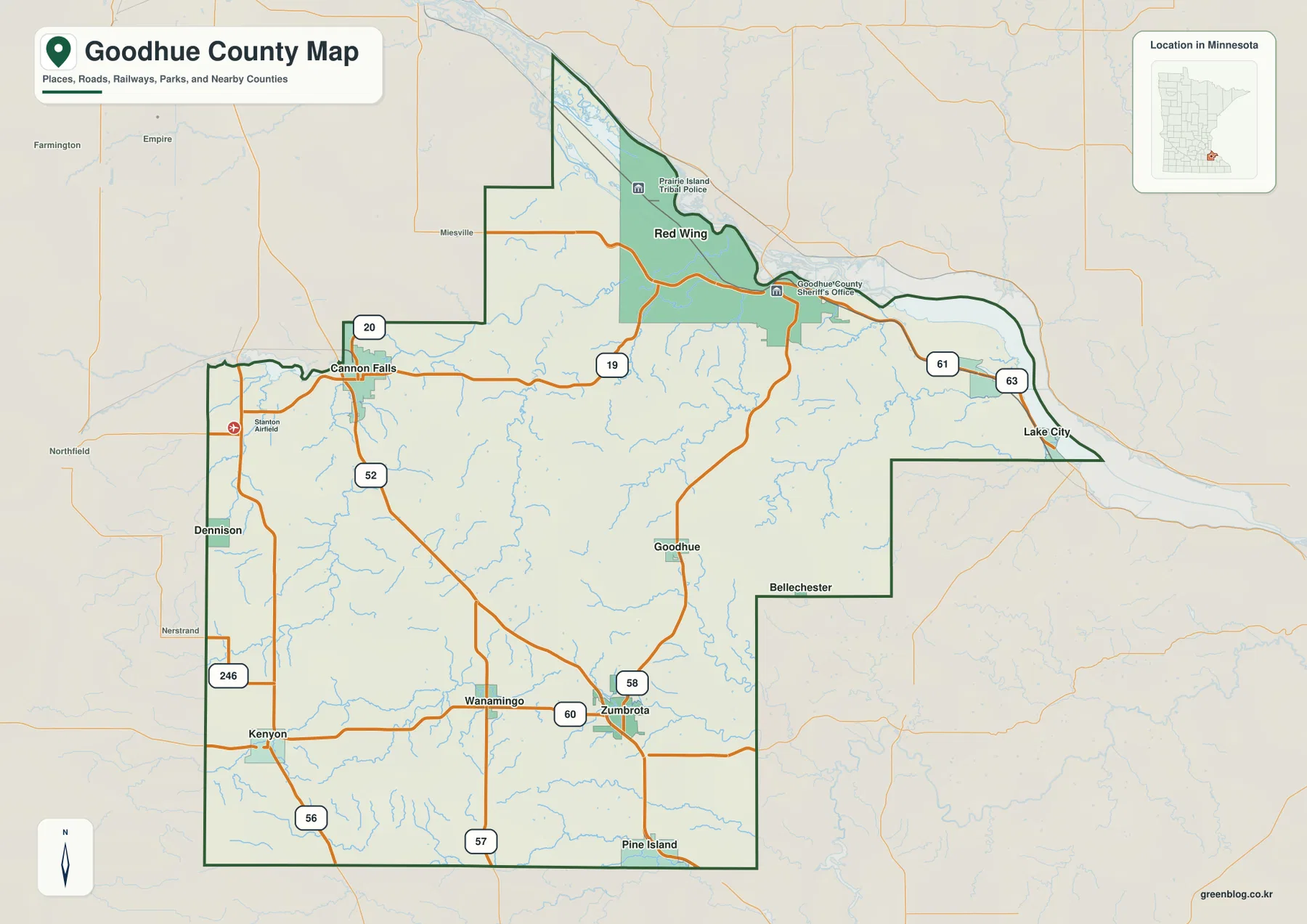
The county outline changes character as it approaches the Mississippi. Western and southern segments are comparatively straight, but the northeastern edge bends around the river and the complex island-and-channel landscape near Prairie Island. That irregular boundary is useful when comparing Goodhue County with neighboring inland counties because it shows how a major river can shape both the edge of a county and the route network inside it. Red Wing sits where those river influences are strongest.
Moving inland, the road map becomes more grid-like. Zumbrota lies near the junction of Highways 58 and 60, Wanamingo is close to the west, and Kenyon provides another reference farther toward the southwestern side. Pine Island appears along the southern boundary near Highway 52. These roads are useful for understanding broad connections, but they are not a live traffic product. Current construction, closures, seasonal conditions, and travel times should be checked with transportation agencies before a trip.
Six mapped cities reveal two different settlement clusters
The city-distribution map strips away most road detail and ranks six major places: Red Wing, Cannon Falls, Zumbrota, Pine Island, Kenyon, and Wanamingo. Red Wing stands apart in the northeast, while Cannon Falls occupies the western side near the Cannon River corridor. The other four cities are concentrated in the southern half of the county, but they are not arranged in one continuous line. Zumbrota and Wanamingo are relatively close, Kenyon sits farther west, and Pine Island marks the southeastern end of the group.
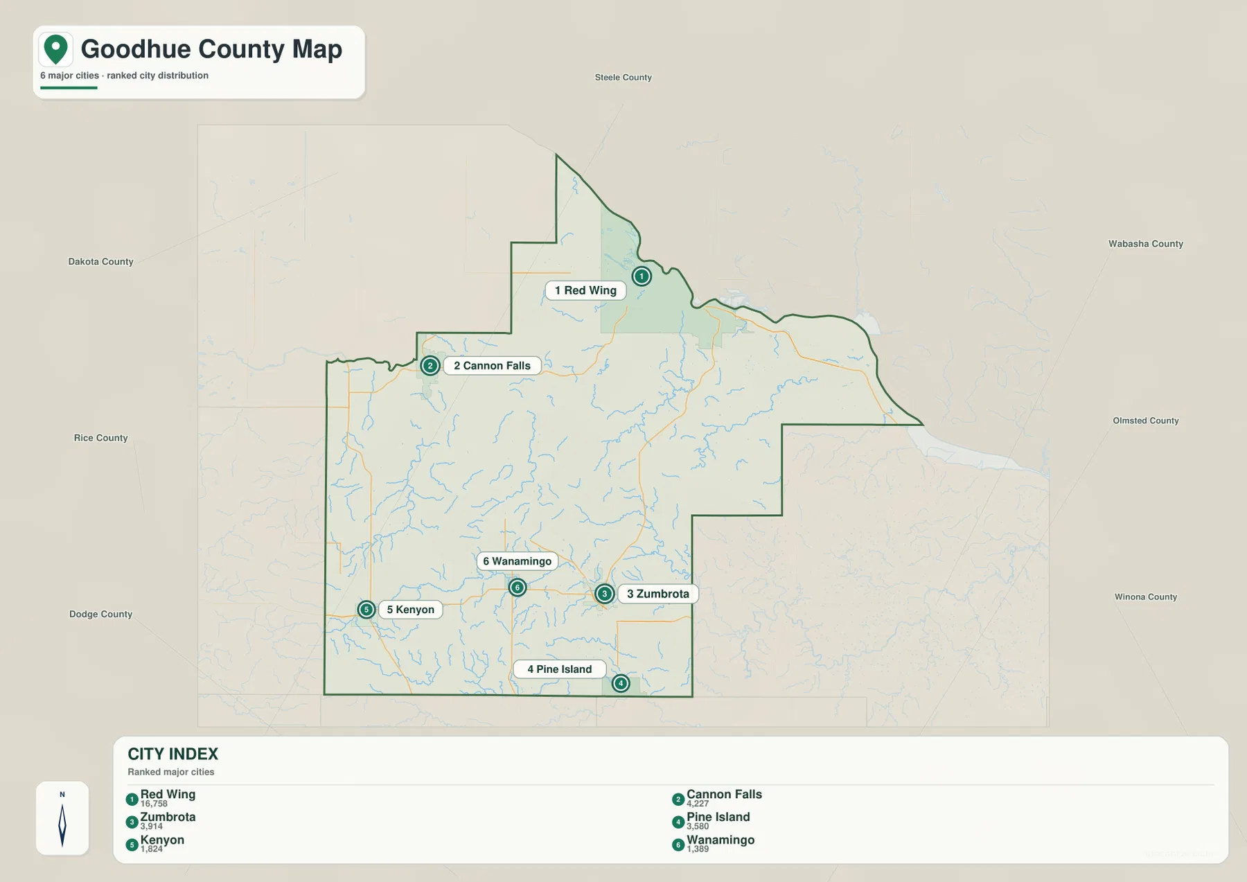
The CITY INDEX on the map lists Red Wing at 16,758, Cannon Falls at 4,227, Zumbrota at 3,914, Pine Island at 3,518, Kenyon at 1,824, and Wanamingo at 1,389. Those figures are part of the map’s ranked-city index and should not be treated as a substitute for the latest official population estimates. Their main value here is comparative: Red Wing is shown as a much larger center, while the other mapped communities form a set of smaller regional anchors.
This map is also useful precisely because it leaves out many details. A classroom slide or report that needs only the relative placement of the six highlighted cities can use the clean background without the visual competition of every numbered road. It should not be used as a distance chart. Screen spacing does not equal driving mileage, and actual routes may bend around valleys or follow different highway connections. For travel planning, use the city map for orientation and return to the general county map for road context.
The Mississippi, Cannon, Vermillion and Zumbro systems divide the landscape
The water-and-terrain map is dominated by the Mississippi River along the northeastern and eastern edge. Near Red Wing, the river expands into a broad floodplain environment with islands and multiple channels before continuing southeast past the Wacouta area. Smaller tributary valleys cut inward from that edge, creating a dense pattern of creeks and ravines. The shape explains why the Red Wing side of the county looks much more dissected than the smoother uplands farther inland.
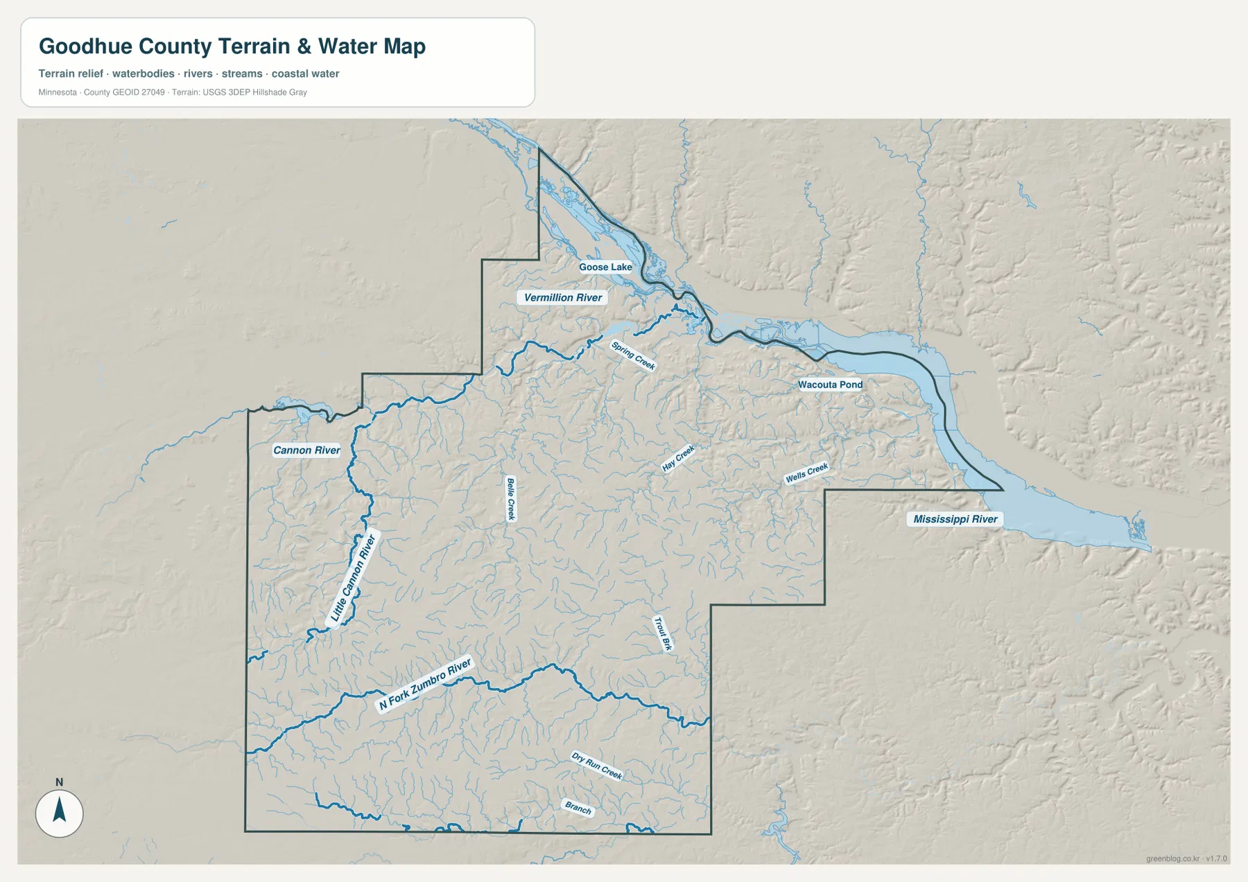
On the western side, the Cannon River enters the county near Cannon Falls and bends toward the northeast. The Little Cannon River approaches from the south and joins that broader system. Farther north, the Vermillion River reaches into the county before turning toward the Mississippi corridor. Spring Creek and Belle Creek occupy smaller valleys between these larger rivers, while Hay Creek and Wells Creek cut through the bluff country closer to the eastern edge.
The southern drainage pattern is different. The North Fork Zumbro River crosses the lower part of the county, accompanied by Dry Run Creek and a web of smaller tributaries. That system is separated from the Cannon and Mississippi corridors by higher ground, so water does not simply move toward one obvious channel across the whole county. For a regional geography lesson, Goodhue County is a useful example of how one county can contain several drainage directions at once.
This is a reference map for the location of rivers, creeks, ponds, and terrain. It is not a floodplain determination, navigation chart, depth map, parcel boundary product, or statement about water access. A stream that appears prominent on the map may have seasonal or local conditions that are not captured here. Flood safety, boating, fishing, and property decisions should rely on the appropriate current county, state, or federal source.
Elevation from about 203 to 368 meters separates bluff valleys from uplands
The elevation map reports an actual county range of roughly 203 to 368 meters, with a mean near 319 meters. The lowest greens follow the Mississippi River and the mouths of tributary valleys along the northeastern edge. Immediately inland, narrow ravines climb quickly toward yellow and orange uplands. In the central and southwestern parts of the county, broader areas of higher ground dominate, although stream valleys continue to cut through them.
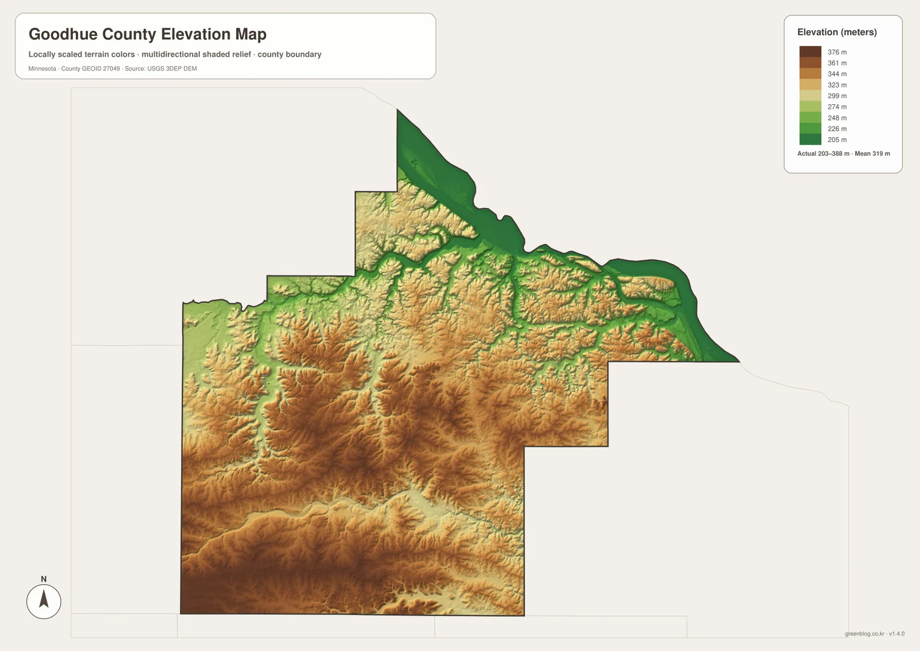
The transition around Red Wing is especially clear. Low river terrain lies close to much higher bluff tops, and tributaries carve narrow green corridors back into the uplands. The Cannon River creates another noticeable valley in the west, while the North Fork Zumbro River cuts across higher southern terrain. Looking at these three areas together shows that relief is not concentrated in one corner; several river systems have shaped deep local differences in elevation.
Southwestern and central Goodhue County appear more elevated overall, but the shaded relief reveals repeated ridges and shallow valleys rather than one flat plateau. Around Kenyon, Wanamingo, and Zumbrota, that rolling surface helps explain why small drainage lines branch in many directions. Pine Island sits near another set of lower channels along the county’s southern edge. Pairing the elevation map with the water map is the easiest way to see how those valleys relate to named streams.
The surface is generalized for county-scale comparison. It is not survey-grade elevation and should not be used to calculate a building pad, road grade, drainage design, or precise parcel elevation. For engineering or detailed site work, consult USGS 3D Elevation Program source data or a professional survey. Here the elevation map is best used to compare the broad river lowlands, bluff slopes, and inland uplands.
Roads and towns make more sense when the river valleys are added
Goodhue County’s settlement pattern becomes clearer when the city and road maps are read against the natural landscape. Red Wing occupies the large Mississippi corridor, where the river provides a strong regional landmark and the bluff edge limits movement to certain valleys and upland approaches. Cannon Falls developed around a different river junction in the west. Between those centers, the county is mostly upland, so roads spread through a more open rural landscape rather than following one continuous urban strip.
The southern cities create another pattern. Zumbrota sits at an important road junction, Wanamingo is nearby to the west, Kenyon occupies the southwestern road network, and Pine Island lies close to Highway 52 near the southern boundary. Their distribution corresponds to rolling uplands crossed by smaller streams rather than the large riverfront setting seen at Red Wing. That difference is easy to miss on the city-only map but becomes obvious once the elevation and water layers are considered.
Cannon Falls also demonstrates the value of switching between maps. On the general map, it is a road hub; on the water map, it is tied directly to the Cannon River valley; on the elevation map, that valley forms a lower route through surrounding higher terrain. Using the same place as a reference point across several map types helps readers understand what each map adds without turning the article into a mechanical list of map products.
Choose the map that matches the question
For county boundaries, major roads, and a broad set of place names, the general county map is the most complete starting point. It is well suited to a local overview, a travel-planning reference, or a presentation that needs both roads and communities. If the goal is simply to compare the six highlighted cities, the city-distribution map is cleaner and keeps attention on location rather than road detail.
The water map is the better choice for explaining the Mississippi, Cannon, Vermillion, and Zumbro systems or showing why creek valleys become dense near the eastern bluffs. Add the elevation map when the question involves high ground, valley depth, or the contrast between river lowlands and inland ridges. The two natural-feature maps work particularly well as a pair because the lower green corridors on the elevation surface can be compared with named waterways.
For printing or editing, use the original JPG files in the download package rather than the smaller WebP images displayed in the article. Each original is 3638 by 2572 pixels, and the archive includes the county, city, water, and elevation maps. A worksheet may need only the city map, while a larger poster can use the general map or combine water and elevation views to explain the landscape without crowding one image with too many labels.
Use county and federal sources for detailed decisions
Goodhue County’s official website identifies Red Wing as the county seat and provides access to county departments and services. The county Surveyor and Geographic Information Systems office maintains GIS resources used for land-related decisions, including maps, parcel information, aerial photography, contours, and public-land-survey data. Those official resources are the appropriate next step when a reader needs more detail than a county overview map can provide.
The county also maintains parks and trail resources that help connect the physical landscape with places people visit. Its Parks & Trails pages cover county facilities such as Byllesby Park and Nielsen Memorial Preserve and link to regional trail systems. The maps on this page are not recreational trail maps, but understanding the Cannon River corridor, Mississippi bluff country, and upland terrain first can make those detailed park resources easier to interpret.
Local terrain can change quickly near bluff edges and stream valleys, so a generalized elevation image should never replace current trail conditions, road information, flood notices, or site-specific measurements. Use the downloadable maps for orientation, education, design layouts, and geographic context, then consult county, state, or federal sources when the decision depends on present conditions or legal accuracy.
Frequently Asked Questions
Which map is best for seeing Red Wing and the Mississippi River bluffs together?
Start with the general county map for Red Wing, U.S. 61 and 63, and the county boundary, then use the elevation map to see the sharp transition from the low Mississippi corridor to the higher bluff tops. The water map adds the river and tributary valleys, which makes the landform relationship even clearer.
Do the Cannon River and North Fork Zumbro River drain the same part of Goodhue County?
No. The Cannon River system is concentrated in the western and northwestern part of the county around Cannon Falls, while the North Fork Zumbro River crosses the southern part. Higher terrain separates those drainage areas, so the county contains several distinct water-flow patterns rather than one dominant inland river system.
Can the 203–368 meter elevation map be used for engineering or parcel surveying?
No. It is a generalized county-scale elevation surface intended to compare river lowlands, bluff slopes, and uplands. Engineering design, road grades, drainage calculations, or parcel-level elevation work should use original USGS elevation data or a professional survey.
Map File Information
Download the four original high-resolution JPG maps shown in this article as one ZIP file.
- Included Files: county map, city map, water map, elevation map
- Printable Size: each JPG is 3638 × 2572 px
- File Type: ZIP containing 4 JPG files
Related Maps
Sources and references
- Goodhue County official website – county government and local information
- Goodhue County Surveyor & GIS – official county mapping and GIS resources
- Goodhue County Parks & Trails – county parks, preserves, and trail information
- U.S. Census Bureau TIGER/Line Shapefiles – boundary, road, and place data
- USGS National Hydrography – rivers, streams, and water data
- USGS 3D Elevation Program – elevation data and products
Green Map creates custom-edited map images using open geographic data sources such as geoBoundaries, Natural Earth, OpenStreetMap, and government open data. These maps are edited visual materials, not raw data files, and are provided for education, documents, presentations, and graphic reference.