Chippewa County lies in western Minnesota, where Montevideo anchors the western side and smaller communities such as Clara City, Milan, Maynard, and Watson are spread across broad agricultural land. The Minnesota River follows the long southwestern boundary, while the Chippewa River approaches from the north and joins it at Montevideo. Elevation rises toward the eastern side, creating a clear contrast between the river lowlands and the higher interior. High-resolution map files are available for download in the section below.
This page combines a general county map, a hub-city connection map, a water map, and an elevation map with an actual range of roughly 265 to 347 meters. High-resolution A3 JPG originals for all four maps are available together in one ZIP for printing, classroom use, trip preparation, and county-scale comparison.
Table of Contents
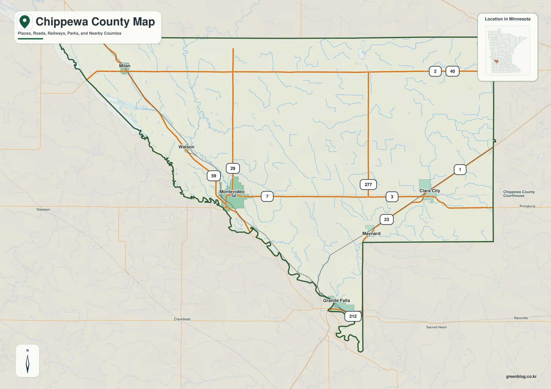
Montevideo at the meeting point of US-59 and the county’s main routes
Montevideo is the strongest orientation point on the general county map. US-59 runs close to the city on the western side, MN-7 continues east across the county, and MN-29 provides another north–south reference through the Montevideo area. These routes make the county seat the easiest place to begin reading the road network.
Milan lies in the northwest near the MN-40 corridor, while Watson sits between Milan and Montevideo. The western half contains many rural roads and drainage features but only small built-up areas outside Montevideo, so settlement spacing increases quickly once the map leaves the county seat.
Clara City is located in the eastern part of the county near the MN-23 corridor, and Maynard lies to its southwest. Granite Falls appears near the southern boundary, where US-212 provides a major regional road reference. The eastern communities therefore connect to a different set of highways than Montevideo and the Minnesota River side.
The county’s long angled western boundary follows the Minnesota River landscape, giving the map a distinctive shape. Montevideo sits where roads and two major river systems come together, while the east is more open and elevated. The map is best used for county-scale orientation rather than live navigation or detailed local street information.
Direct connections from the Montevideo hub
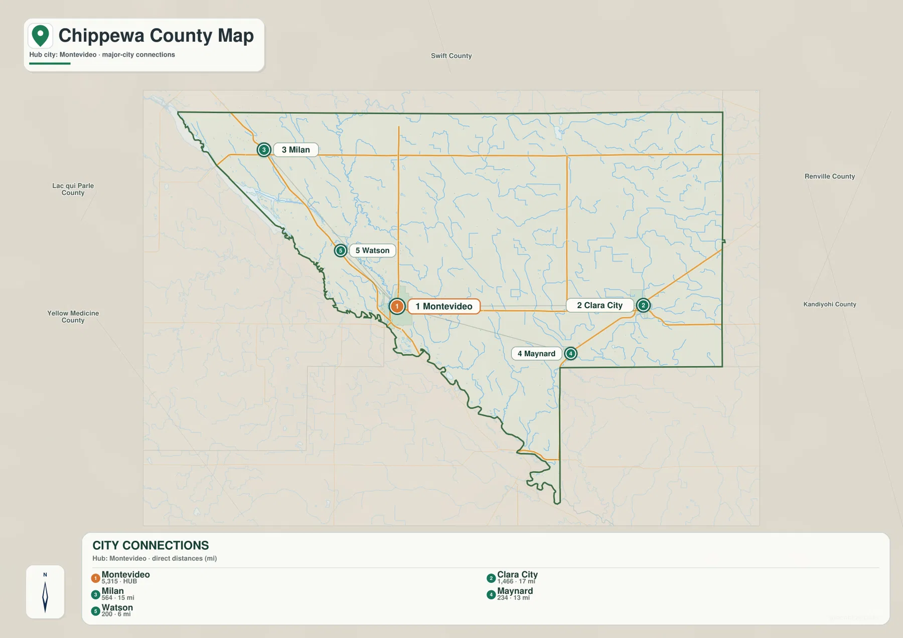
The city connection map uses Montevideo as the hub and links it with Clara City, Milan, Maynard, and Watson. Montevideo carries a printed value of 5,315, while Clara City is labeled 1,466, Milan 564, Maynard 234, and Watson 200. These values are reproduced from the supplied graphic and are not presented here as newly calculated population estimates.
The map also prints straight-line distances from Montevideo. Watson is shown at 6 miles, Maynard at 13 miles, Milan at 15 miles, and Clara City at 17 miles. These are direct distances rather than driving mileage, so actual routes can be longer depending on road alignment, river crossings, and the available highway network.
The directions help explain the county’s layout. Watson and Milan lie northwest of Montevideo, Clara City is to the east, and Maynard is southeast of the hub. The connection graphic provides a quick sense of direction and scale, while the general county map is better for understanding the roads used to travel between those places.
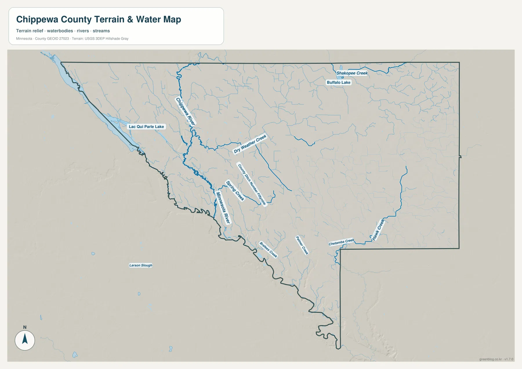
Chippewa River meets the Minnesota River at Montevideo
The most important water relationship is the confluence at Montevideo. Chippewa River enters the county from the north and flows south to the Minnesota River. The Minnesota Pollution Control Agency describes the Chippewa River as flowing about 130 miles southwest before joining the Minnesota River at Montevideo, matching the confluence shown on the map.
Minnesota River follows much of the county’s western and southwestern boundary, while Lac qui Parle Lake occupies a broad water corridor near the northwest edge. The river and lake are surrounded by low channels, tributaries, and wet ground, making the western side much more water-dominated than the higher eastern interior.
Across the north and east, smaller waterways become the main references. Shakopee Creek, Dry Weather Creek, and Spring Creek are labeled across the northern and central areas, while Buffalo Lake sits near the north-central portion. In the southeast, Chetamba Creek and Hawk Creek form longer named channels through otherwise open agricultural land.
Palmer Creek and other small tributaries continue the drainage pattern across the center and south. The Chippewa River itself broadens as it approaches Montevideo and the Minnesota River valley. Comparing the water and elevation maps makes the relationship especially clear: the largest channels occupy long green low corridors, while the eastern side stands higher.
Use the water map for names, relative positions, and broad drainage relationships. It does not show flood probability, legal shoreline limits, navigation depth, parcel ownership, or current water conditions. Those questions require current products from the responsible public agency.
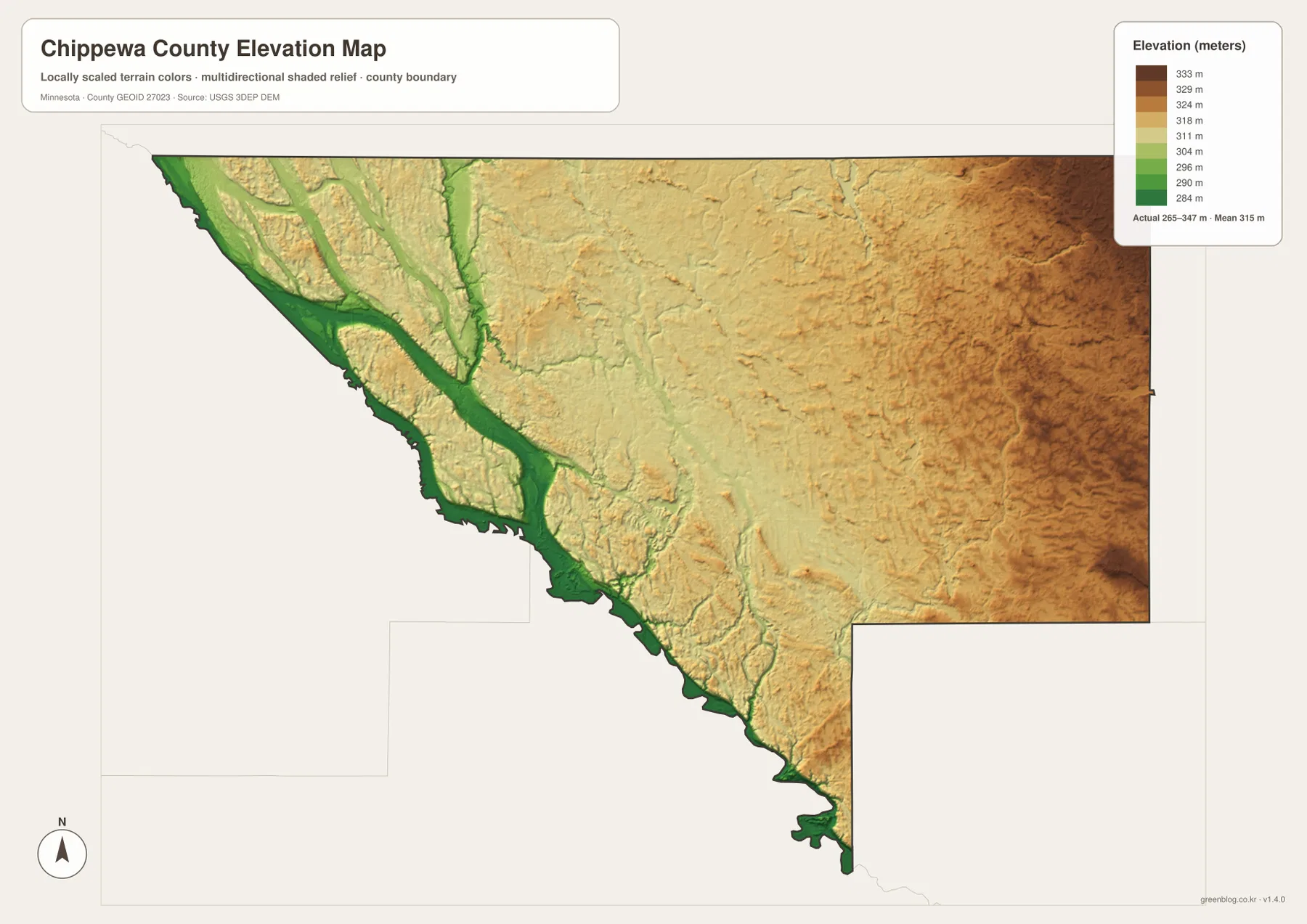
Elevation from 265 to 347 meters
The elevation map reports an actual range of about 265 to 347 meters and a mean near 315 meters. Greens represent lower terrain, while tan and brown colors mark higher ground. The lowest continuous areas follow the Minnesota River and Chippewa River corridors in the west and southwest, including the Montevideo confluence.
The Chippewa River valley remains visible as a green corridor extending north from Montevideo. Lower terrain also surrounds the Lac qui Parle Lake side of the western boundary. These broad river lowlands stand out from the more uniform interior surfaces to the east.
Across the center, terrain is generally moderate and gently rolling. Elevation increases toward the east, with the highest brown areas concentrated near the northeastern and eastern edge. Clara City and Maynard lie on noticeably higher interior ground than the Montevideo river corridor, even though local creeks create smaller low channels.
The county-wide difference is roughly 82 meters. That is modest compared with mountainous regions, but it clearly separates the major river valleys from the eastern uplands. This surface is intended for broad terrain comparison rather than survey-grade measurement; precise construction, drainage, engineering, or site work requires more detailed official elevation data and field verification.
Montevideo, Clara City, and Milan show three sides of the county
Montevideo combines the strongest road network with the county’s most important river setting. US-59, MN-7, and MN-29 provide major references, while the Chippewa and Minnesota rivers meet beside the city. The elevation map places this area in the broad western lowlands, making roads, water, and relief easy to compare in one place.
Clara City and Maynard represent the higher eastern interior. MN-23 and local east–west routes provide the main road references, while Chetamba Creek and Hawk Creek replace the large river corridors seen around Montevideo. The terrain is higher and the landscape is more open, with smaller settlements spread across broad agricultural land.
Milan and Watson occupy the northwestern side closer to the Minnesota River and Lac qui Parle Lake corridor. The hub map makes their direct distance from Montevideo easy to compare, while the water and elevation maps show how the western lowlands differ from the eastern uplands. The county’s main geographic contrast is therefore visible across a relatively short west-to-east span.
Chippewa County’s official website lists Montevideo, Clara City, Granite Falls, Maynard, Milan, and Watson among its local-government communities. The map set is useful for understanding their broad locations, but parcel boundaries, flood regulation, road construction, and other legal or operational questions should be checked with current county, state, or federal sources.
Frequently Asked Questions
Is the 17 miles from Montevideo to Clara City a driving distance?
No. The supplied city connection map labels 17 miles as the direct, straight-line distance from the Montevideo hub to Clara City. The 6 miles to Watson, 13 miles to Maynard, and 15 miles to Milan use the same direct-distance method.
Where do the Chippewa and Minnesota rivers meet?
They meet at Montevideo. The water map shows the Chippewa River approaching from the north and joining the Minnesota River along the western river corridor.
Can the 265–347 meter elevation range be used for engineering or surveying?
No. The elevation layer is suitable for broad comparison of higher and lower terrain, but precise construction, drainage, engineering, or survey work requires more detailed official elevation data and field verification.
Map File Information
A ZIP containing the high-resolution A3 JPG originals for the Chippewa County map, city connection map, water map, and elevation map.
- Included Files: county map, city connection map, water map, elevation map
- File Type: JPG
Related Maps
Sources and references
- U.S. Census Bureau TIGER/Line Shapefiles – official geographic files for county boundaries, roads, and place references.
- USGS National Hydrography – federal source for rivers, streams, lakes, and other hydrographic features.
- USGS 3D Elevation Program – official U.S. elevation and terrain data resources.
- Chippewa County official website – official county government, local-government links, resident services, and current county information.
- Minnesota Pollution Control Agency – Chippewa River – official watershed information describing the river and its confluence with the Minnesota River at Montevideo.
Green Map creates custom-edited map images using open geographic data sources such as geoBoundaries, Natural Earth, OpenStreetMap, and government open data. These maps are edited visual materials, not raw data files, and are provided for education, documents, presentations, and graphic reference.