Beltrami County covers a large part of northern Minnesota, combining the Bemidji-centered southern population area with the enormous Upper and Lower Red Lake waters farther north. Blackduck, Kelliher, Tenstrike, Wilton, and Solway are much smaller communities separated by broad stretches of forest, wetlands, lakes, and rivers. The contrast between the low northern lake country and the rougher southern uplands becomes especially clear when the road, water, and elevation maps are compared. High-resolution map files are available for download in the section below.
This page combines a general county map, a six-city ranking index, a water map, and an elevation map with an actual range of roughly 355 to 459 meters. High-resolution A3 JPG originals for all four maps are available together in one ZIP for printing, classroom use, trip preparation, and side-by-side geographic comparison.
Table of Contents
Bemidji, Blackduck, and Kelliher on the main road network
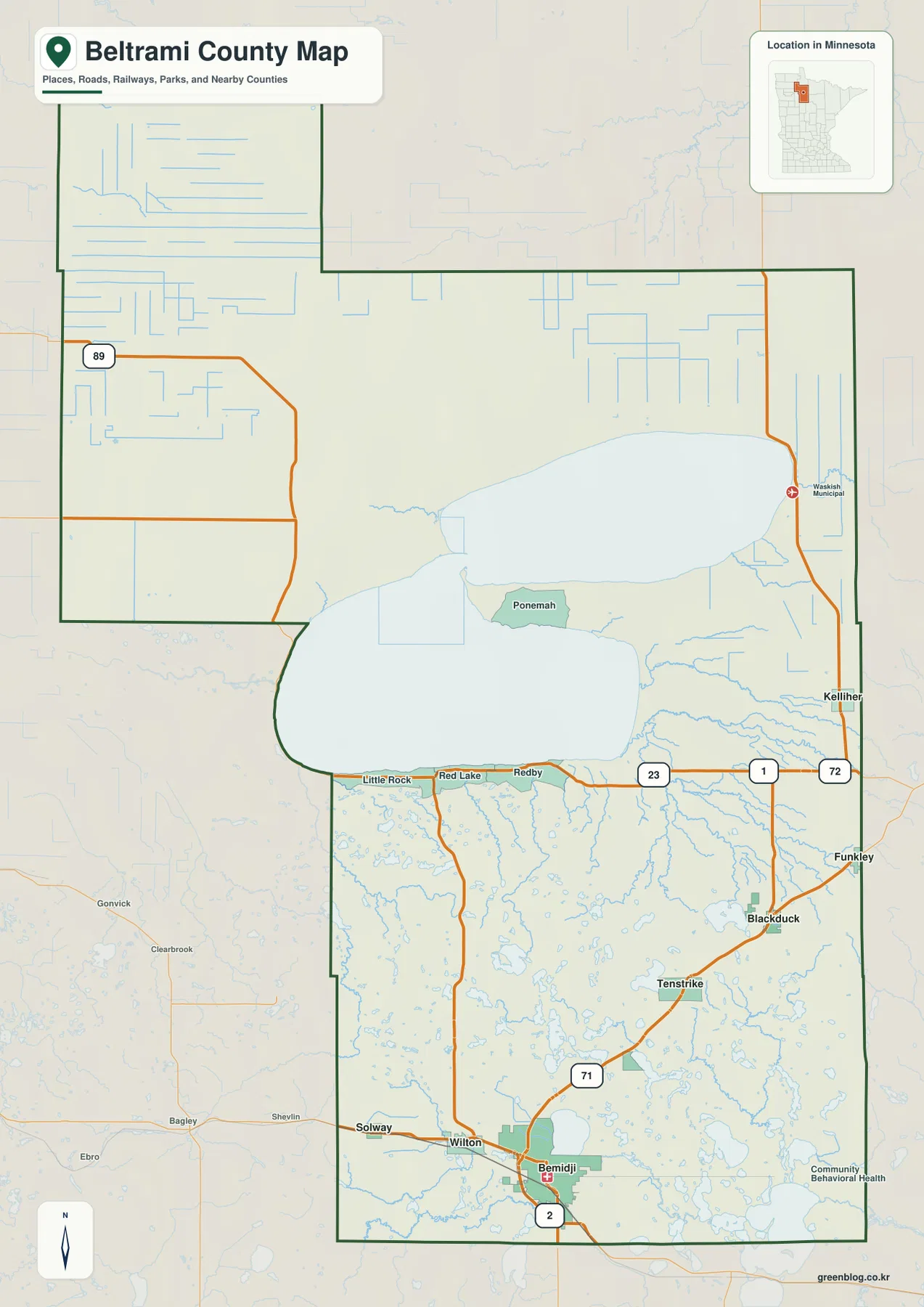
Bemidji is the strongest orientation point on the general county map. US-2 crosses the city from west to east, while US-71 provides the main north–south route. Wilton and Solway sit west of Bemidji, and the road network becomes progressively less dense as it moves toward Tenstrike and Blackduck in the northeast.
North of Blackduck, the highway corridor continues toward Kelliher. MN-1 crosses the southern edge of the Red Lake area through the Red Lake and Redby side before continuing toward Kelliher, while MN-72 runs along much of the eastern side of the county. MN-89 appears in the northwest, serving a landscape that is far less urban than the Bemidji end of the map.
Little Rock, Red Lake, and Redby are clustered near the southern margin of the large Red Lake waters. Here the lake surface takes up far more space than the road network, and routes are concentrated along the accessible shoreline and surrounding land. Kelliher and Blackduck provide useful intermediate references between this lake-dominated north and the more developed Bemidji area.
The county outline is unusually large and irregular, with a northwestern extension and broad inland lake areas shaping the middle of the map. Starting with the full county view makes it easier to understand why Bemidji, Blackduck, Kelliher, and the Red Lake communities feel so far apart and why the main highways serve very different settings.
Six ranked communities led overwhelmingly by Bemidji
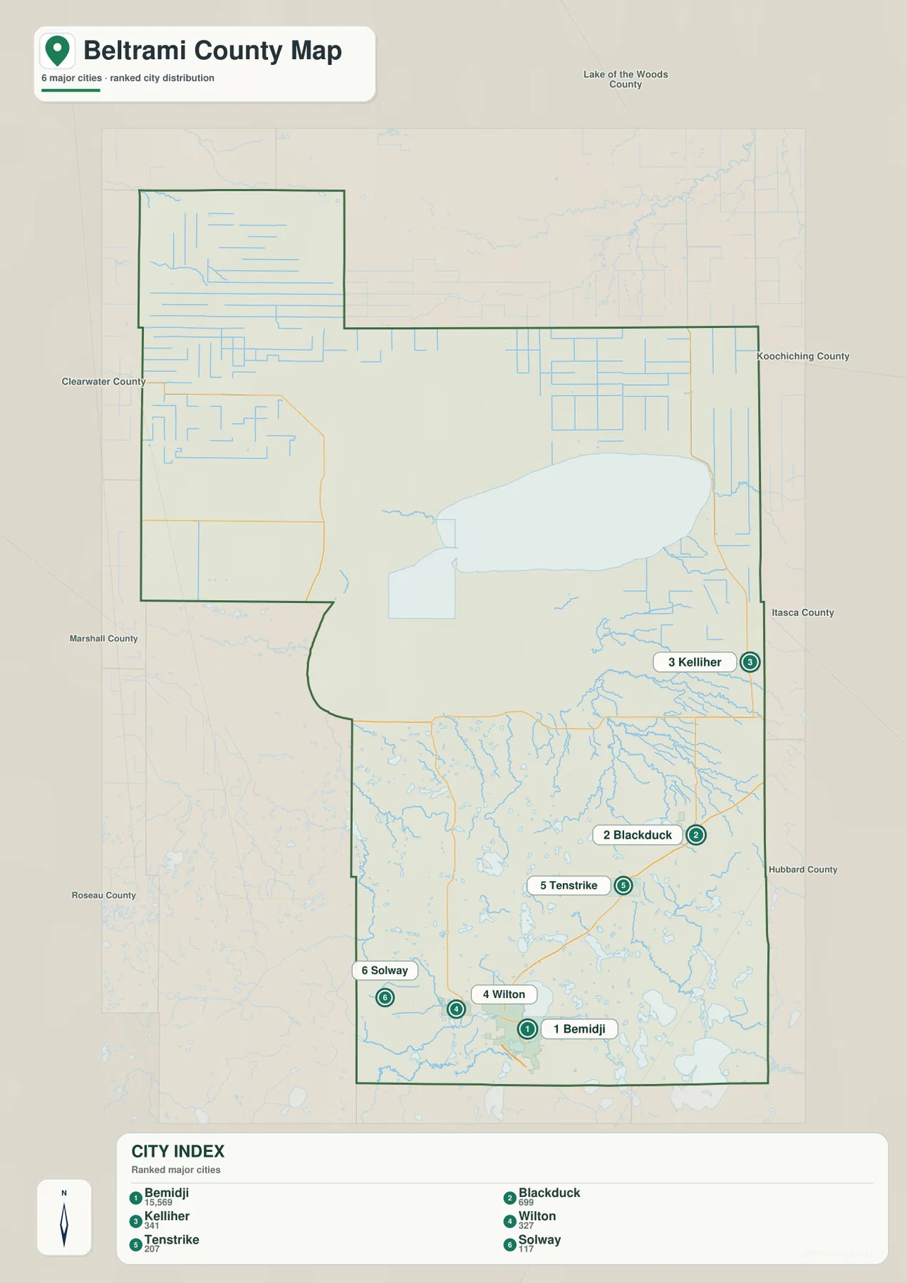
The city index ranks six selected communities. Bemidji is number 1 with a printed value of 15,569, followed by Blackduck at 699, Kelliher at 341, Wilton at 327, Tenstrike at 207, and Solway at 117. These figures are reproduced from the supplied city-index graphic and are not presented here as newly calculated population estimates.
The distribution shows Bemidji in the south, with Wilton and Solway close by to the west. Tenstrike and Blackduck form a northeastward sequence, while Kelliher sits much farther north. Bemidji’s printed value is dramatically larger than those of the other ranked places, reinforcing the contrast between the county’s southern city center and its widely scattered smaller communities.
There are no connector lines or mileage labels on this city map. It is a ranking and location graphic rather than a distance chart. Use it to compare where the six selected communities sit within the county, then refer to the general road map or a current routing service when actual driving mileage or travel time is needed.
Upper and Lower Red Lake above the Mississippi River country
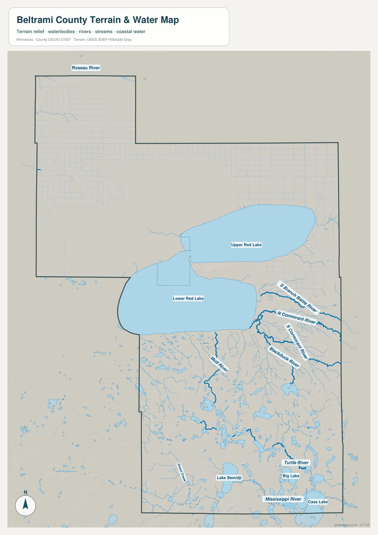
Upper Red Lake and Lower Red Lake dominate the northern half of the water map. Their combined footprint is far larger than any other named water feature in the county, and the two broad lake basins divide the northern and southern land areas visually. Upper Red Lake extends farther east, while Lower Red Lake occupies a large basin to the southwest.
Several rivers drain the country east and southeast of Red Lake. North Cormorant River, Cormorant River, and Blackduck River are clearly labeled, while South Branch Battle River appears farther north. These waterways show that the Blackduck–Kelliher side is not simply lake shoreline; it includes a broad network of low river corridors and wet ground.
The southern county contains a different water system. Mississippi River reaches the Bemidji and Cass Lake side, Turtle River runs through the southeastern interior, and Lake Bemidji lies immediately north of the city. Big Lake and Cass Lake appear farther southeast, while Grant Creek provides a smaller named stream west of Bemidji.
Roseau River is labeled near the far northwestern edge, and Mud River runs south of Lower Red Lake. Countless smaller lakes, ponds, and wet channels fill the area between the major named waters. The result is a county where water shapes nearly every region, but the dominant feature changes from Red Lake in the north to the Mississippi headwaters landscape in the south.
Beltrami County’s Natural Resource Management Department provides a local recreation connection to this water-rich landscape. In the county’s first-quarter 2026 newsletter, NRM says it manages six county parks—Three Island, Rognlien, Movil Maze, Mississippi High Banks, Grant Creek Horse Camp, and Wilton Hill—covering more than 4,000 acres and supporting activities from hiking and biking to riding and winter recreation.
Use the water map for names, relative positions, and broad drainage relationships. It does not show flood probability, legal shoreline limits, navigation depth, parcel ownership, or current water conditions. Those questions require current products from the responsible public agency.
Elevation from 355 to 459 meters
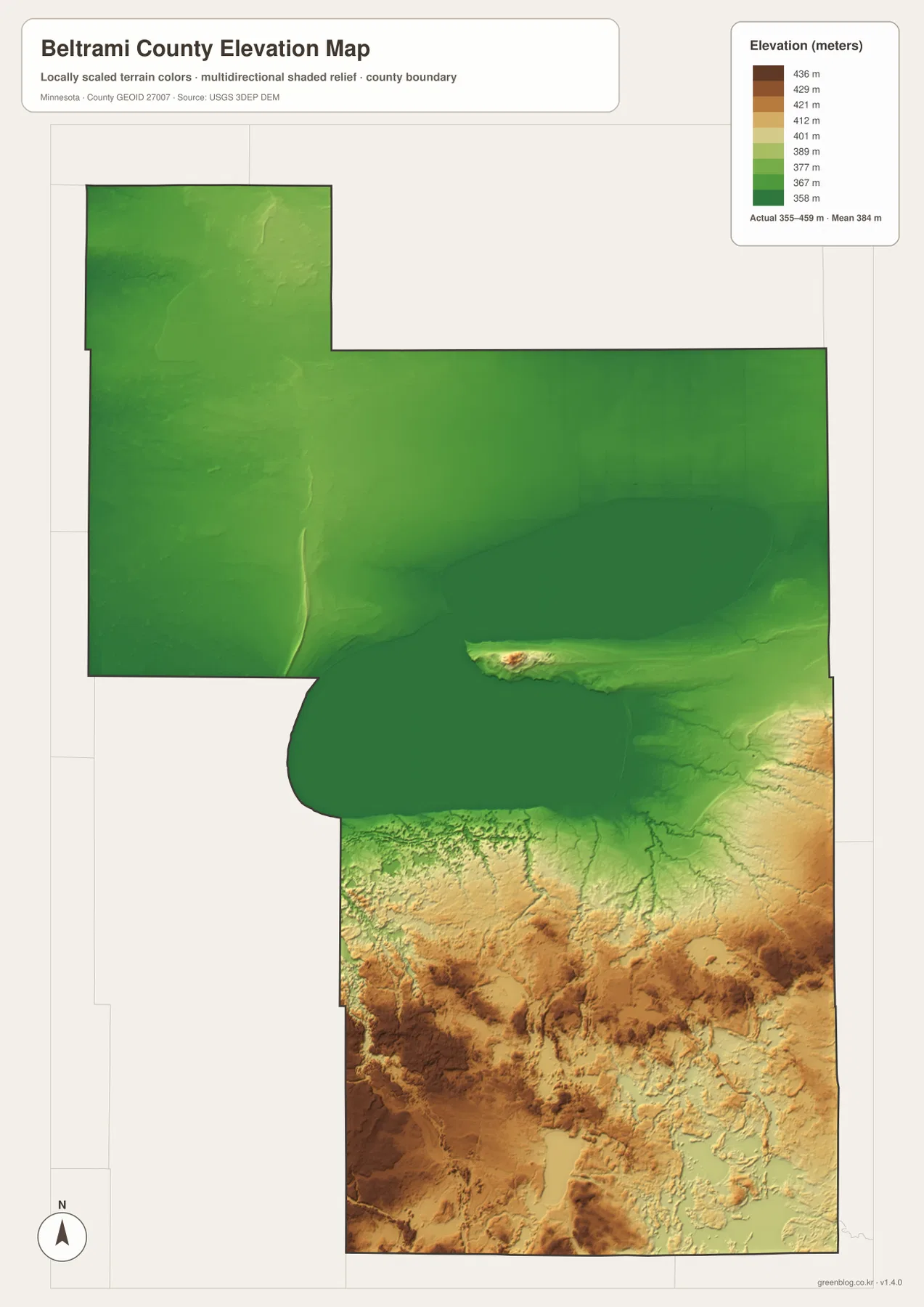
The elevation map reports an actual range of about 355 to 459 meters and a mean near 384 meters. Greens represent lower terrain, while tan and brown colors mark higher ground. Most of the northern half, including the Red Lake surroundings, appears broad, low, and comparatively smooth.
South of Red Lake, the terrain changes quickly. Rolling hills and narrow valleys become much more common, and the southwestern part of the county contains some of the darkest brown high ground. The area west and southwest of Bemidji is especially different from the flat-looking northern lake country.
The southeast is also noticeably higher than the north. Around the route from Blackduck toward Bemidji and Cass Lake, ridges and lower stream corridors alternate across the terrain. The Red Lake region remains the broadest low area, while the southern half shows much more local variation in relief.
The county-wide difference is roughly 104 meters. That is not mountain-scale relief, but it is enough to distinguish the northern lowlands from the southern uplands and to make river corridors and lake basins visible. This layer is intended for broad terrain comparison rather than survey-grade measurement; precise construction, drainage, engineering, or site work requires more detailed official elevation data and field verification.
Why Bemidji, Blackduck, and Red Lake feel like different regions
Bemidji brings the road, water, and relief layers together in the south. US-2 and US-71 form the strongest transportation junction, Lake Bemidji sits directly beside the city, and the Mississippi River passes through the broader southern lake country. Elevation is also more varied here than around Red Lake, with hills and valleys surrounding the city area.
Blackduck and Tenstrike occupy a quieter transition zone. The road network is thinner, the Blackduck and Cormorant river systems become more prominent, and elevation drops toward the Red Lake lowlands. Kelliher sits even closer to the giant lake system, where open water and broad flat terrain dominate the map much more than city development.
The Red Lake area is the county’s most visually distinctive northern setting. Upper and Lower Red Lake take up enormous space, smaller rivers spread around their eastern and southern sides, and the surrounding ground is comparatively low. In contrast, the Bemidji side mixes roads, lakes, rivers, and rougher uplands much more tightly.
The set works well for general county orientation, school assignments, local-history presentations, and trip preparation. It does not replace parcel records, zoning documents, flood-regulation products, legal surveys, or real-time transportation information, so specialized decisions should rely on current county, state, or federal sources.
Frequently Asked Questions
Which maps best show the difference between Bemidji and Red Lake?
Start with the general county map for roads and settlement locations, then compare the water and elevation maps. Bemidji is a southern road and lake center with more rolling terrain, while the Red Lake region is dominated by enormous water bodies and broad low ground.
Are the city-index values current population estimates?
The values described here are the numbers printed in the supplied city-index graphic. For the latest population figures, use current U.S. Census Bureau or Beltrami County statistics rather than treating the map values as a new estimate.
Can the 355–459 meter elevation range be used for engineering or surveying?
No. The elevation map is suitable for broad comparison of higher and lower terrain, but precise construction, drainage, engineering, or survey work requires more detailed official elevation data and field verification.
Map File Information
A ZIP containing the high-resolution A3 JPG originals for the Beltrami County map, city index, water map, and elevation map.
- Included Files: county map, city index map, water map, elevation map
- File Type: JPG
Related Maps
Sources and references
- U.S. Census Bureau TIGER/Line Shapefiles – official geographic files for county boundaries, roads, and place references.
- USGS National Hydrography – federal source for rivers, streams, lakes, and other hydrographic features.
- USGS 3D Elevation Program – official U.S. elevation and terrain data resources.
- Beltrami County official website – official county government, resident services, maps, and local information.
- Beltrami County 1st Quarter 2026 Newsletter – official Natural Resource Management and county parks information.
Green Map creates custom-edited map images using open geographic data sources such as geoBoundaries, Natural Earth, OpenStreetMap, and government open data. These maps are edited visual materials, not raw data files, and are provided for education, documents, presentations, and graphic reference.