Monroe County occupies the southeastern corner of Michigan’s Lower Peninsula, where inland roads and rivers meet the western shore of Lake Erie. Monroe is the county’s main urban center, but the map also spreads attention across Dundee, Carleton, South Rockwood, Luna Pier, Temperance, Petersburg, Ida, and other communities. The maps on this page show the county boundary, important roads and rail lines, the distribution of major cities, named waterways, and the gradual change in elevation from the western interior toward the lakeshore. High-resolution JPG versions of the same maps are available in the download box below.
The county’s geography is easier to understand when three features are used as anchors: Lake Erie on the east, the River Raisin running through Monroe, and the broad road network linking the county to Detroit, Toledo, and inland southern Michigan. Monroe sits close to the low shoreline, while Dundee and Petersburg lie farther west on slightly higher ground. Carleton and South Rockwood occupy the northern part of the county, and the southern edge meets Ohio, giving Monroe County a clear position between two large metropolitan regions without making the county itself feel uniformly urban.
Table of Contents
A Lake Erie county centered on Monroe and the River Raisin
Monroe County is one of Michigan’s southernmost counties and reaches the Lake Erie shore along its eastern edge. Wayne and Washtenaw Counties lie to the north, Lenawee County is to the west, and Ohio is immediately south. That combination gives the county an unusual mix of lakeshore, borderland, small-city, suburban, and agricultural settings. On the overview map, the long north-south shoreline contrasts with the straighter western and southern county boundaries, while Monroe stands out near the eastern side rather than at the geographic center.
Monroe is the county seat and the place where the River Raisin reaches the most developed part of the county before continuing toward Lake Erie. Monroe County’s official history says the county was established in 1817 and that the former settlement of Frenchtown became Monroe and the county seat that same year. The river also connects the modern city to the River Raisin National Battlefield Park, which preserves and interprets the January 1813 battles fought at Frenchtown during the War of 1812. This historical setting makes the River Raisin more than a map label: it is a useful geographic line for understanding how settlement, transportation, and local history overlap in Monroe.
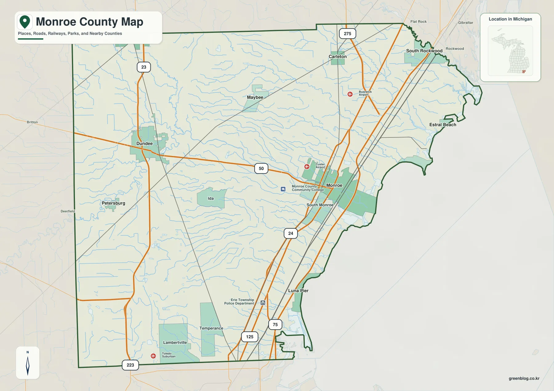
Several smaller communities help define the county beyond Monroe. Dundee and Petersburg sit in the western half, Ida and Maybee occupy the interior, and Carleton and South Rockwood mark the northern portion. Along the Lake Erie side, Estral Beach and Luna Pier show how settlement also follows the shoreline. Temperance and Lambertville form a broad developed area near the Ohio line, where the county’s southern communities are closely tied to the Toledo region. Seeing all of these places together prevents Monroe County from being reduced to a single city or a single transportation corridor.
I-75, US-23, and M-50 organize travel across the county
The eastern transportation spine is I-75, which runs north-south near Monroe and the Lake Erie side of the county. It provides the clearest long-distance route toward Detroit to the north and Toledo to the south. Farther west, US-23 passes near Dundee and creates a second north-south corridor through the inland part of the county. M-50 crosses between Dundee and Monroe, visually tying those two corridors together. This arrangement is easy to see on the overview map and gives a practical framework for explaining the county’s road geography without listing every local street.
Other routes add detail to the pattern. I-275 reaches the northern portion near Carleton, while US-24, US-223, and M-125 serve parts of the southern and central county. The road network becomes denser around Monroe and the Ohio-border communities, while the western interior retains more open space between settlements. For a classroom map or a regional report, it is often helpful to mark I-75 and US-23 first, then add M-50 and the smaller communities. Doing so makes the relative positions of Monroe, Dundee, Temperance, and the Lake Erie coast much easier to explain.
Rail lines are also visible on the overview map, especially in the eastern half where transportation and developed areas overlap. These lines are useful for general orientation, but the map is not intended for live navigation, legal right-of-way questions, or current service status. Its strength is county-scale context: a reader can see where the major roads, railways, cities, and shoreline sit in relation to one another before turning to a more detailed source for turn-by-turn travel or property information.
The city map shows a dispersed pattern rather than one continuous urban area
The city-distribution map highlights six places so their positions can be compared without the extra detail of the full overview. Monroe is ranked first on the supplied city index, followed by Dundee, Milan, Carleton, South Rockwood, and Luna Pier. The numbered symbols are an index for the map, not a travel sequence. They make it immediately clear that the principal communities are spread across several parts of the county rather than forming one continuous cluster along the Lake Erie shoreline.
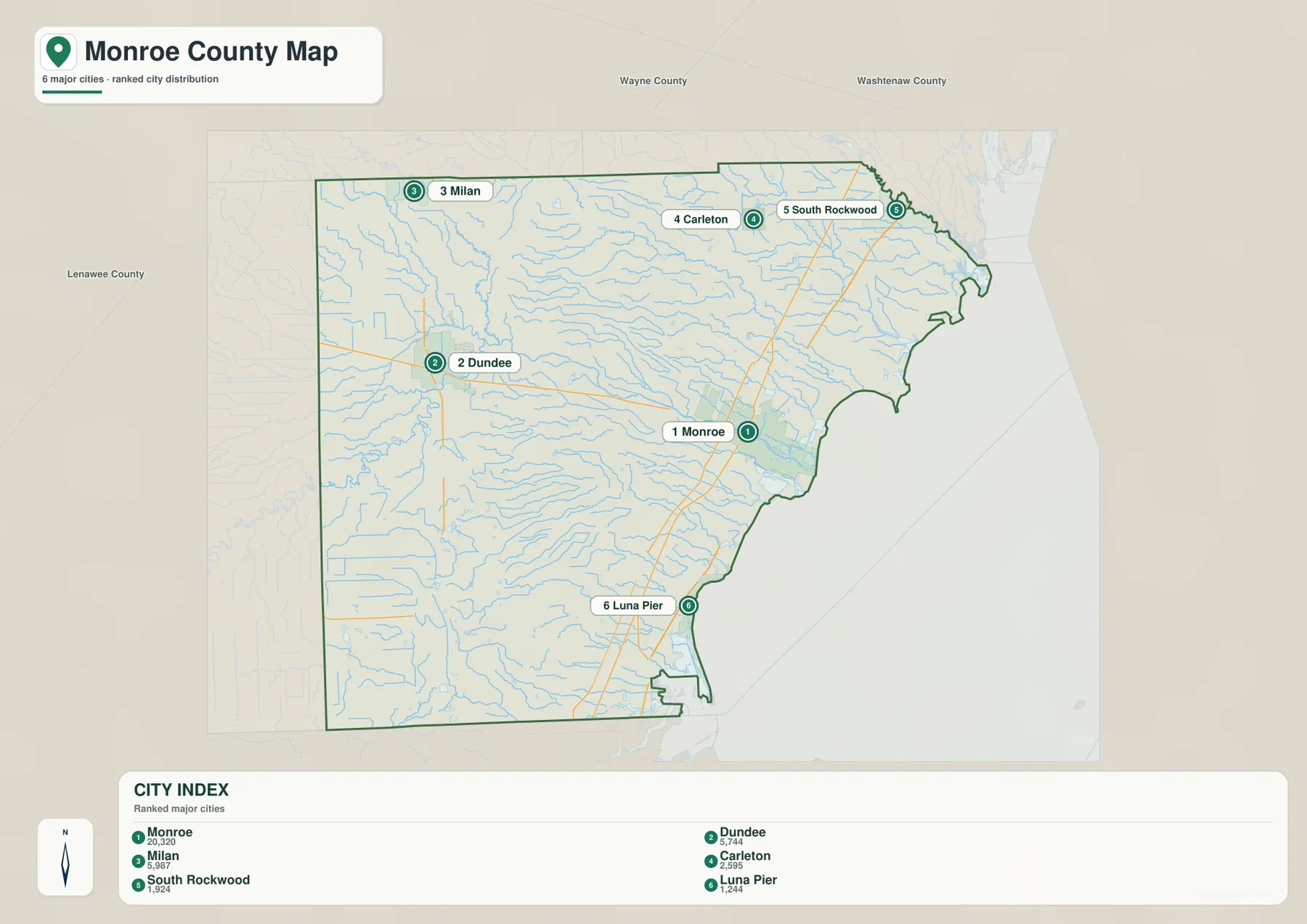
Monroe anchors the eastern side near the River Raisin and I-75. Dundee lies well to the west near US-23 and M-50, making it the clearest inland counterpart to Monroe. Carleton and South Rockwood are farther north and closer to Wayne County, while Luna Pier sits near the southeastern Lake Erie shore. Milan appears near the northwestern edge, where Monroe County meets the Washtenaw County area. The result is a map with several separate local centers connected by highways and county roads rather than a single uninterrupted metropolitan strip.
This version is particularly useful when the question is about relative location. A presentation can show Monroe as the eastern anchor, Dundee as the western inland center, and Carleton or South Rockwood as northern reference points without the visual competition of every road and stream. The numbered symbols show relative position and the supplied city ranking; they do not represent driving distance or travel time. Those values must be calculated from actual road networks.
River Raisin, creeks, and bays lead toward Lake Erie
The water map makes the county’s drainage pattern much more visible than the road-focused overview. The River Raisin is the best-known waterway, crossing the county toward Monroe and the Lake Erie shore, but it is part of a much denser network. Macon River and Saline River appear in the western and northwestern portions, while Sandy Creek, Stony Creek, Swan Creek, Little Swan Creek, Bay Creek, Little Creek, and smaller channels spread across the interior. Their paths are generally more winding than the road grid and gradually converge toward the lower eastern side of the county.
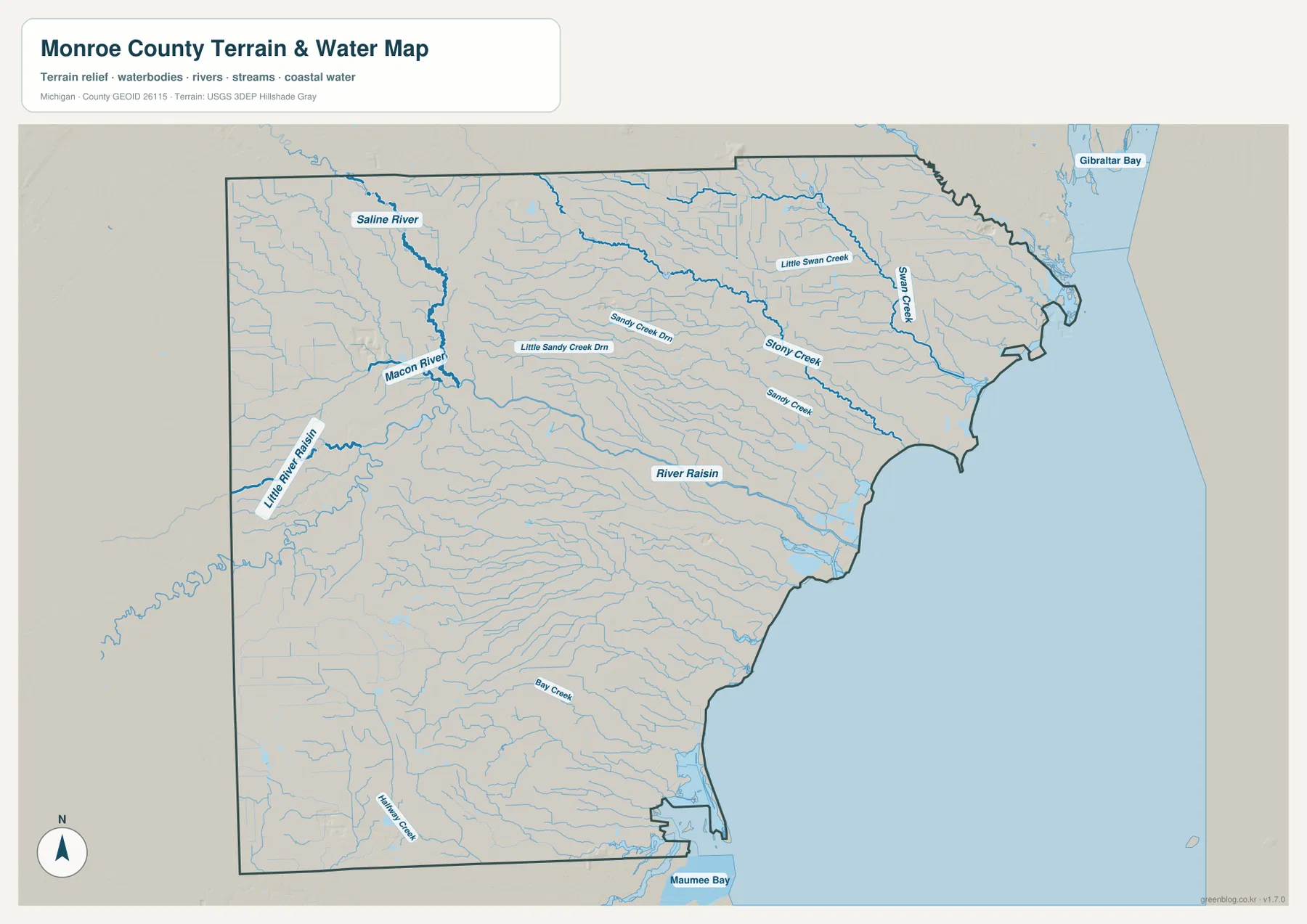
Gibraltar Bay is labeled near the northeastern lakeshore, while Maumee Bay appears toward the southern end of the map. Between those two areas, the Lake Erie edge forms a long receiving boundary for the county’s streams and river systems. Around Monroe, the River Raisin is the most important visual connection between inland landforms and the shore. Farther north, the Swan Creek system approaches the lake, while central and southern creeks drain lower ground toward the same broad basin.
This map should be used as a water-reference and terrain-orientation map, not as a flood-risk, parcel, legal-boundary, or navigation product. It can help a student identify named streams, help a writer describe the county’s relationship to Lake Erie, or help a local-history presentation place the River Raisin in geographic context. Flood insurance, wetland regulation, navigable-water questions, and engineering work require specialized official datasets. Keeping that distinction clear prevents a general reference map from being used for decisions it was never designed to support.
Elevation falls gently from the western interior toward the lakeshore
The elevation map shows a broad west-to-east transition rather than steep mountain relief. Brown and tan colors dominate the western edge, indicating relatively higher ground, while lighter greens and deeper greens become more common toward Monroe and Lake Erie. The county therefore appears as a gently sloping landscape in which the western interior sits above the low lakeshore plain. This helps explain why many streams move generally eastward and why the River Raisin reaches a broad, low setting around Monroe before entering the Lake Erie system.
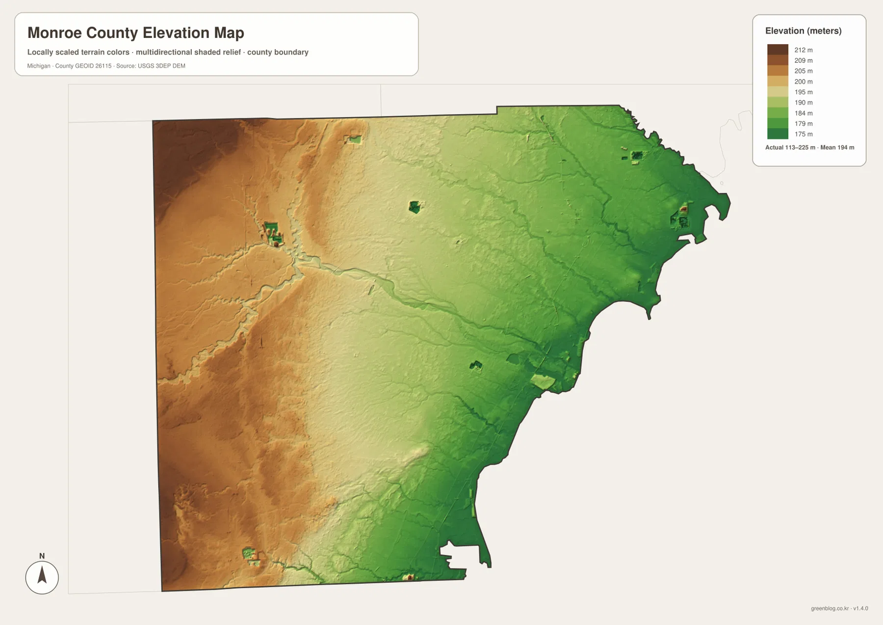
Dundee and Petersburg lie in the warmer-colored western side of the county, while Monroe, South Rockwood, Estral Beach, and Luna Pier are closer to the lower green terrain near the lake. The differences are modest compared with mountainous parts of Michigan or the eastern United States, but they remain meaningful at county scale. A gentle elevation gradient is enough to influence drainage direction, the shape of stream valleys, and the broad contrast between inland agricultural landscapes and the low coastal edge.
The shaded surface is designed to show regional relief clearly, not to provide survey-grade elevations for individual properties. Construction, drainage design, flood analysis, and precise site planning require detailed measurements and authoritative project data. For general geography, however, the map is useful because it turns an otherwise subtle landform difference into a visible pattern. Readers can quickly connect the higher west, lower east, River Raisin corridor, and Lake Erie shoreline without needing a technical contour map.
Choosing the right Monroe County map for a project
The county overview is the best starting point when roads, communities, boundaries, railways, and general orientation all matter. It works well for a report introducing Monroe County, a classroom worksheet about southeastern Michigan, or a presentation that needs to place Monroe and Dundee in relation to Detroit, Toledo, and Lake Erie. Because the map already includes recognizable routes and place names, it requires less annotation than the more specialized versions.
The city map is better when the main question is where major communities sit relative to one another. The water map should be chosen for the River Raisin, creeks, bays, and the shoreline, while the elevation map is the clearest choice for explaining why the western interior stands above the eastern lakeshore. Using the specialized map that matches the topic keeps a slide or printed page easier to read. It also avoids forcing road, water, city, and elevation information into one overly crowded graphic.
The downloadable JPGs are sized for high-resolution use and can be printed at A3 landscape dimensions. They can also be inserted into a document or slide deck and cropped to emphasize a smaller area. A useful teaching sequence is to begin with the county overview, compare the city distribution next, then use the water and elevation maps to explain why the River Raisin and Lake Erie are so important to Monroe County’s physical setting. The four views work together, but each remains readable on its own.
Frequently Asked Questions
What are the best landmarks for orienting yourself on a Monroe County map?
Start with Lake Erie on the east, Monroe near the River Raisin, and I-75 running north-south close to the eastern side of the county. Once those three elements are located, Dundee and US-23 are easy to place farther west, Carleton and South Rockwood can be found to the north, and Luna Pier and the Ohio-border communities fall naturally into position to the south. This approach is faster than trying to learn every town and road at once.
Which map is most useful for understanding the River Raisin and Lake Erie shoreline?
The water map is the clearest choice because it separates named rivers and creeks from the road-heavy background. It shows the River Raisin crossing toward Monroe and Lake Erie while also identifying Macon River, Swan Creek, Stony Creek, Bay Creek, and other waterways. Pairing it with the county overview is useful when you also need to explain where Monroe, Dundee, or the major highways sit in relation to those water features.
Can the elevation map be used for engineering, property, or flood decisions?
No. The elevation image is a county-scale reference designed to show the broad difference between higher western ground and the lower Lake Erie side. It is not a substitute for a survey, engineering-grade elevation model, flood insurance rate map, or parcel record. Use it for general geographic explanation and visual comparison, then consult the appropriate official source when a decision depends on exact elevation, ownership, or flood-risk information.
Map File Information
Download the high-resolution JPG versions of the Monroe County maps shown on this page in one ZIP archive.
- Included Files: county map, city map, water map, and elevation map
- File Type: ZIP containing four JPG images
Related Maps
Sources and references
- Monroe County, Michigan – Monroe County History for county establishment and local historical context
- U.S. National Park Service – River Raisin National Battlefield Park for the Monroe battlefield location and historical setting
- U.S. Census Bureau – TIGER/Line Shapefiles for county and transportation boundary reference
- U.S. Geological Survey – National Hydrography for waterways reference
- U.S. Geological Survey – 3D Elevation Program for elevation reference
Green Map creates custom-edited map images using open geographic data sources such as geoBoundaries, Natural Earth, OpenStreetMap, and government open data. These maps are edited visual materials, not raw data files, and are provided for education, documents, presentations, and graphic reference.