Mason County sits on the Lake Michigan side of Michigan’s Lower Peninsula, with Ludington on the western shore and a chain of inland communities extending through Scottville and Custer toward the county’s eastern side. US-10 provides the clearest east-west reference across the county, while US-31 helps orient travel through the western half. Farther north, Fountain and Free Soil occupy the interior away from the Ludington corridor. The downloadable package on this page includes the same four county map themes as high-resolution JPG files for closer viewing and printing.
The county is especially easy to understand when roads, water, and terrain are viewed together rather than as separate subjects. Hamlin Lake is a large inland-water landmark near the northwest, the Big Sable River crosses the northern part of the county, and the Pere Marquette River forms a strong westward-running feature across the south. The elevation image then adds another layer: low ground follows much of the Lake Michigan side and the major river corridors, while higher ridges become more prominent toward the east and southeast.
Table of Contents
US-10 gives Ludington, Scottville, and Custer an easy east-west reference
Start with Ludington on the Lake Michigan shore. From there, US-10 runs east through Scottville and continues toward Custer and the Lake County line. That sequence creates the simplest framework for locating the county’s main western and central communities. Scottville is close enough to Ludington to feel like part of the same broad travel corridor, while Custer sits farther inland and provides a useful reference before the road reaches the eastern edge of Mason County.
US-31 adds a north-south route through the western part of the county, linking areas south of Ludington with the direction of Manistee County to the north. M-116 follows the Lake Michigan side north of Ludington and is important for understanding the shoreline near Hamlin Lake. The county map also marks West Shore Community College, Mason County Airport, and selected medical and fire-service locations. Those labels make it easier to see that many public services and transportation points cluster near Ludington, Scottville, and the larger roads rather than being evenly distributed across the entire county.
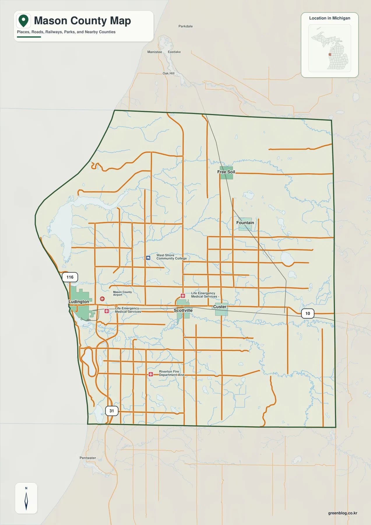
The outer boundary is another useful orientation tool. Manistee County lies to the north, Lake County to the east, Oceana County to the south, and Lake Michigan defines the western side. The shoreline bends noticeably, unlike the comparatively simple straight administrative edges on the east and south. This is a county-scale reference map, so it should not be used to determine parcel ownership, surveyed property lines, or temporary road restrictions. Those tasks require current county GIS, land records, or live transportation data.
The settlement map shows how the inland communities spread away from Ludington
The city-connections map simplifies the county to five highlighted communities: Ludington, Scottville, Custer, Fountain, and Free Soil. Ludington is the western reference point at Lake Michigan. Scottville lies almost directly east, and Custer continues farther along the same general US-10 direction. Fountain and Free Soil sit farther north in the interior, so the map quickly shows that the county’s settlement pattern is not a single continuous east-west line.
Straight-line distances printed on the map give another way to compare those places. Scottville is shown about 8 miles from Ludington, Custer about 11 miles, Fountain about 15 miles, and Free Soil about 16 miles. These are direct distances rather than driving distances, so road mileage and travel time will vary with the route. The population-style values printed beside the community labels are best treated as map reference values, not as a substitute for the newest Census estimates.
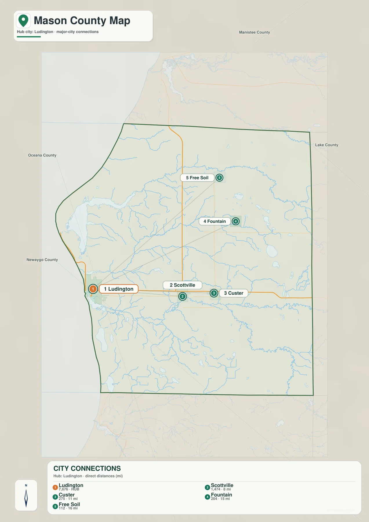
This simpler view is useful before returning to the more detailed county map. Once the relative positions are familiar, the local road network is much easier to follow. Free Soil marks the northern interior near the Manistee County side, Fountain provides a central-north reference, and the Ludington–Scottville–Custer line anchors the southern half of the main settlement pattern. For navigation, the map works best as an orientation aid rather than a turn-by-turn guide.
Hamlin Lake, the Big Sable River, and the Pere Marquette River divide the county into distinct water settings
Hamlin Lake is the dominant inland-water feature near the northwest corner of the county. Its position just inside the Lake Michigan shoreline makes it an easy landmark even before tracing the smaller streams. North and east of the lake, the Big Sable River curves across the northern part of Mason County. Numerous smaller tributaries feed into the system, giving the northern interior a much more intricate drainage pattern than the road map alone suggests.
The central part of the county contains a different mix of waterways. North Branch Lincoln River and South Branch Lincoln River cross the interior, while smaller lakes such as Gun Lake, Ford Lake, Round Lake, Tallman Lake, and Hacker Lake appear nearby. Instead of one large water body controlling the view, this area is characterized by repeated small lakes and branching streams. That combination is particularly noticeable east of the Ludington–Scottville area and around the broader Fountain side of the county.
South Mason County is organized around the Pere Marquette River. It runs westward toward Lake Michigan, with the Big South Branch Pere Marquette River joining from the southeast. Farther south, North Branch Pentwater River and Swan Creek form another set of waterways, and Bass Lake appears close to the southwestern edge. Comparing the Big Sable system in the north with the Pere Marquette system in the south is one of the clearest ways to understand why the county has several very different river landscapes within a relatively compact area.
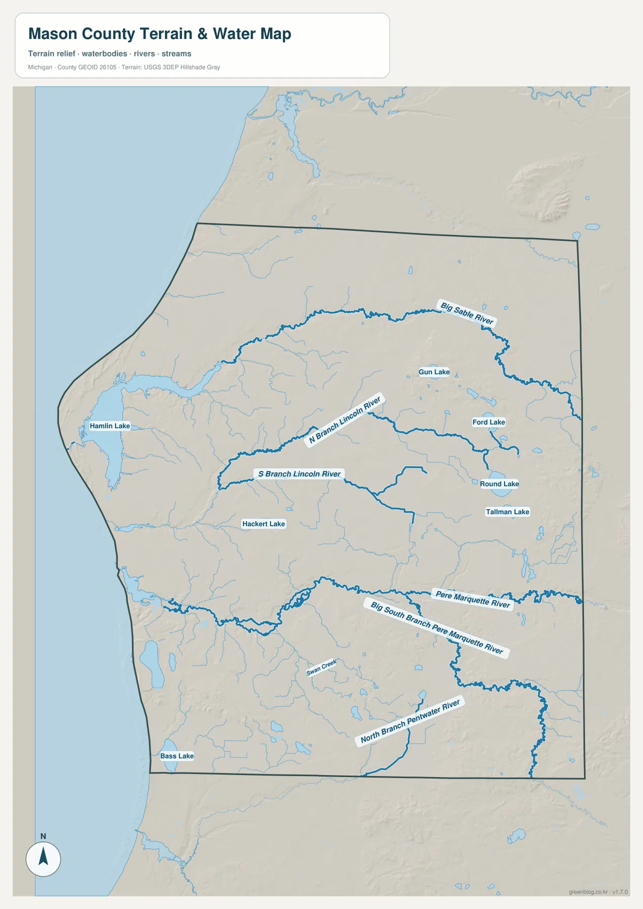
The water map is intended for geographic reference rather than current hydrologic conditions. It is useful for locating rivers, lakes, and tributaries, but it does not provide real-time flow, flood depth, navigable channels, wetland jurisdiction, or safe boating conditions. For those purposes, current USGS water information, FEMA products, and local or state guidance should be consulted. As a county overview, however, the map makes the contrast between Hamlin Lake, the northern river system, and the broad southern Pere Marquette corridor especially clear.
Low shoreline and river valleys contrast with higher eastern and southeastern ridges
The elevation map reports an actual county range of about 176 to 288 meters, with a mean near 210 meters. Lower green shades cover much of the Lake Michigan side, including Ludington and areas around Hamlin Lake. The Big Sable and Pere Marquette corridors also form long lower bands through the county. When the elevation image is compared with the water map, many of the major streams line up naturally with the lower terrain.
Higher ground becomes much more noticeable toward the east and southeast. Broad brown and tan ridges occupy parts of the lower-right portion of the map, and additional elevated terrain appears in the east-central interior. There are also isolated higher features near the southwestern Lake Michigan side, so the shoreline should not be treated as uniformly flat. The county does not contain mountain-scale relief, but the difference of more than 100 meters between mapped low and high points is enough to produce visible valleys, slopes, and ridges.
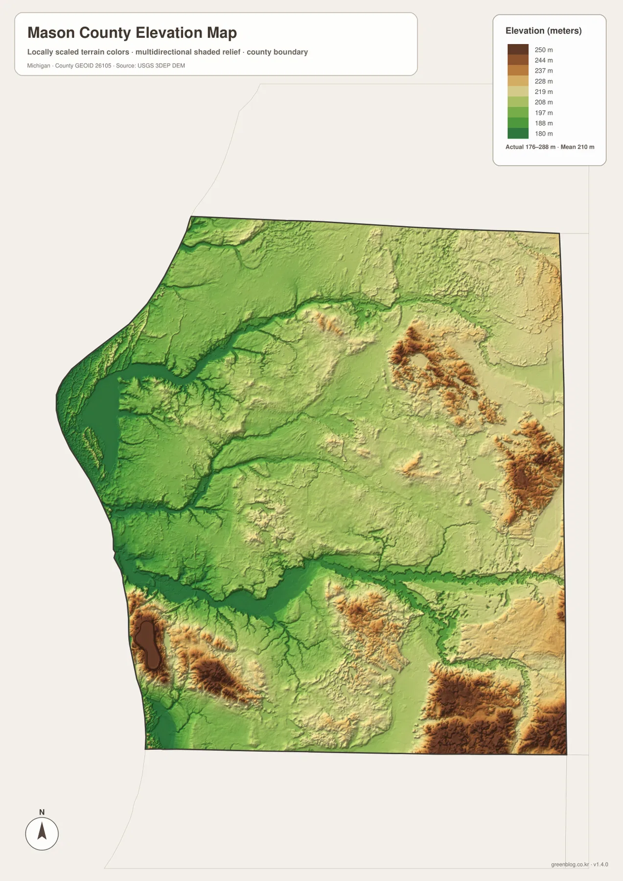
The elevation colors are locally scaled for comparison within Mason County. A brown area does not automatically mean steep mountainous terrain, and the image cannot provide survey-grade elevation at a house lot, bridge, or road point. Construction, drainage design, flood planning, and engineering should use authoritative elevation data and site measurements when necessary. For general study, the map is most valuable for showing how the low Pere Marquette valley sits between higher uplands and how the western shore differs from the eastern interior.
A practical way to use the maps is to move from roads to water and then to relief
For a quick orientation, begin at Ludington and follow US-10 through Scottville to Custer. Add US-31 to understand the western north-south route, then use M-116 to identify the shoreline direction north of Ludington. Once those references are familiar, locating Fountain and Free Soil in the northern interior becomes straightforward. This sequence is useful for trip planning, classroom work, or anyone who wants to learn the county without trying to absorb every road label at once.
Next, shift attention to the water features. Hamlin Lake gives the northwest a strong landmark, Big Sable River defines much of the northern river setting, the Lincoln River branches fill the middle, and Pere Marquette River dominates the south. The elevation map then explains why many of those waterways follow greener low ground while the eastern and southeastern parts rise into warmer colors. Moving through the maps in that order creates a coherent picture of Mason County from the Lake Michigan shoreline to the inland ridges.
The WebP images in the article are optimized for browser viewing. The download archive contains four 3638 × 2572 pixel JPG originals, which are more useful when labels need to be enlarged or when preparing printed reference sheets. Use the general map for roads and community locations, the city-connections map for settlement spacing, the water map for rivers and lakes, and the elevation map for comparing low valleys with higher ground. These are general-reference maps and are not replacements for live navigation, legal parcel records, flood maps, marine charts, or engineering surveys.
Frequently Asked Questions
Which map is easiest for comparing Ludington, Scottville, Custer, Fountain, and Free Soil?
The city-connections map is the quickest option because it reduces the view to five highlighted communities and shows their directions and direct distances from Ludington. If you also need road numbers, surrounding place names, and county boundaries, use the general county map immediately afterward.
Where are Hamlin Lake and the Pere Marquette River shown most clearly?
The terrain-and-water map is best. It clearly labels Hamlin Lake in the northwest, Big Sable River across the north, the Lincoln River branches in the central area, and the Pere Marquette and Big South Branch Pere Marquette systems in the south, along with several smaller lakes and tributaries.
Can the 176–288 meter elevation range be used for construction or flood decisions?
No. The elevation map is a county-scale reference for comparing broad areas of lower and higher ground. Exact site elevation, drainage grades, flood-protection levels, road engineering, and parcel surveys require current authoritative data and professional measurements when appropriate.
Map File Information
The ZIP includes high-resolution JPG originals of the Mason County general map, city-connections map, terrain-and-water map, and elevation map. They are suitable for closer label inspection, classroom use, and personal reference printing.
- Included Files: Use only the versions confirmed in the article and supplied images
- File Type: Use the confirmed download contents
- Intended Use: Printing, education, presentations, and map-based projects
Related Maps
Sources and references
- Mason County, Michigan official website: official county information and local-government reference.
- Mason County Comprehensive Data Book: county planning reference covering communities, natural resources, and transportation context.
- U.S. Census Bureau TIGER/Line Shapefiles: official reference data for boundaries and roads.
- USGS National Hydrography: reference data for rivers, streams, and lakes.
- USGS 3D Elevation Program: authoritative elevation-data reference.
Green Map creates custom-edited map images using open geographic data sources such as geoBoundaries, Natural Earth, OpenStreetMap, and government open data. These maps are edited visual materials, not raw data files, and are provided for education, documents, presentations, and graphic reference.