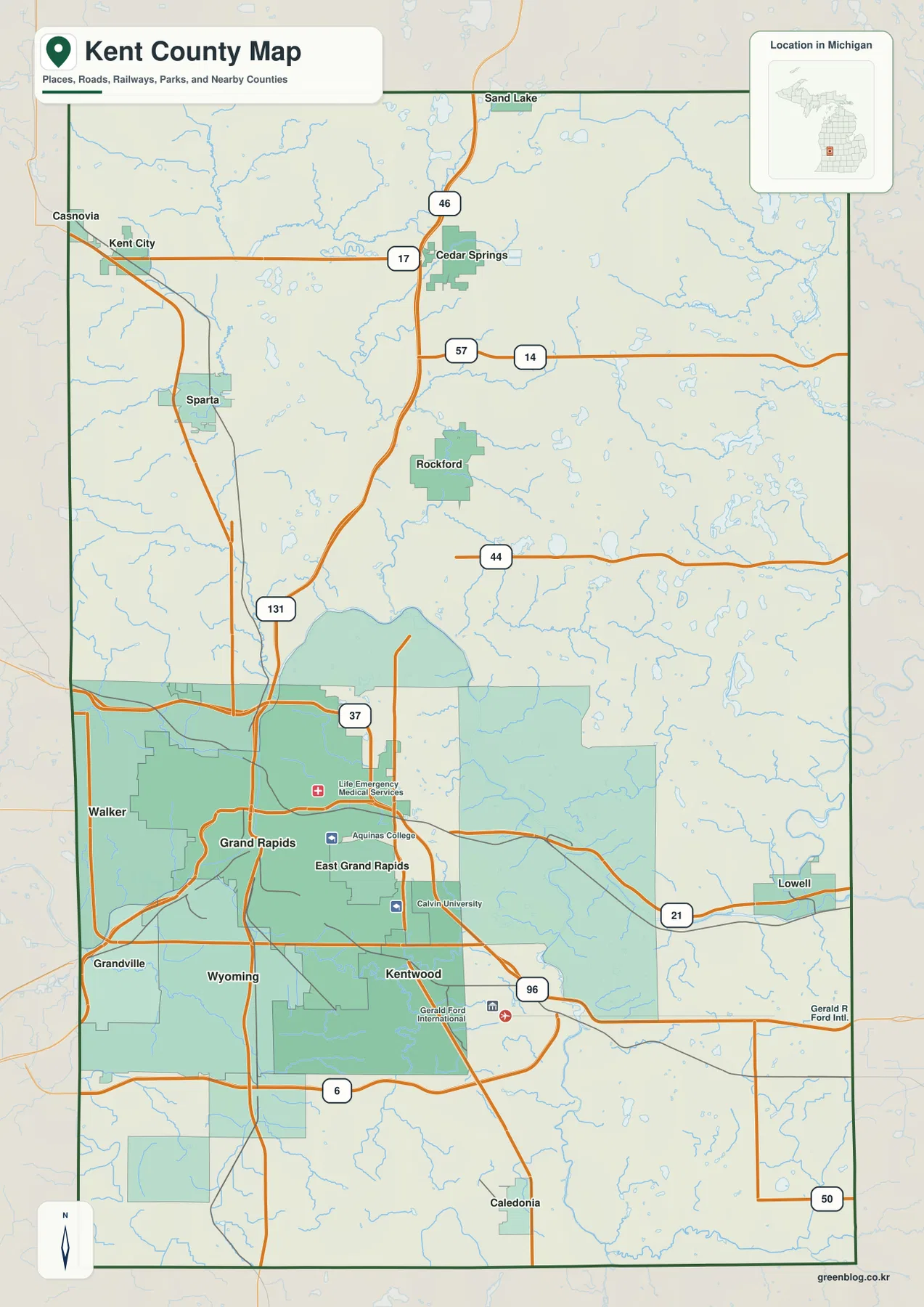
Kent County in West Michigan combines a concentrated metropolitan area around Grand Rapids with a much more open northern half of small cities, river valleys, lakes, and rural roads. Grand Rapids, Wyoming, Kentwood, Walker, Grandville, and East Grand Rapids cluster in the southwest, while Rockford, Cedar Springs, Sparta, Kent City, and Lowell provide useful reference points farther from the urban core. US-131 is the clearest north-south route through the county, with M-21, M-44, M-57, M-46, M-37, and M-6 helping define the surrounding areas.
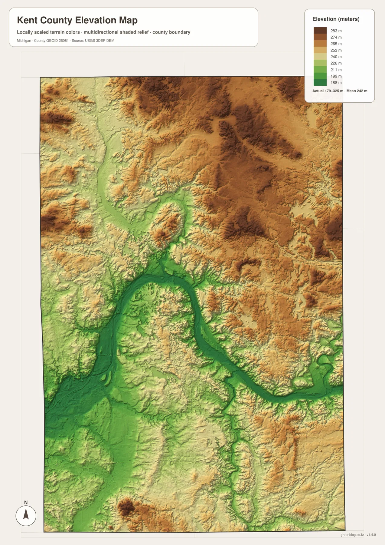
The physical landscape adds another layer to that road pattern. The Grand River bends through the center and southwest, Rogue River drains the northwest, Flat River marks the east, and the Thornapple River crosses the southeast. The elevation map reports an actual county range of about 179 to 325 meters, with a mean near 242 meters, and it clearly separates the low Grand River corridor from higher northeastern terrain. High-resolution JPG versions of the supplied maps are available in the ZIP download for close zooming or printing.
Table of Contents
Grand Rapids dominates the southwest while US-131 links the metro area to Rockford and Cedar Springs
The general county map is anchored by the Grand Rapids urban area. Grand Rapids sits near the center of a broad developed cluster, with Walker to the west, Grandville to the southwest, Wyoming and Kentwood to the south, and East Grand Rapids immediately to the east. Gerald R. Ford International Airport appears east of Kentwood and gives the southeastern side of the metro area another recognizable landmark. The concentration of municipal areas here contrasts sharply with the more open northern half of Kent County.
US-131 passes through the urban core and continues north toward Rockford and Cedar Springs. M-6 crosses the southern side of the metropolitan area, while M-21 runs east from Grand Rapids toward Lowell. M-37 provides another north-south reference through the central part of the county. These routes make the southwest comparatively easy to orient because several large roads intersect or run close together; farther north, communities are separated by longer stretches of rural land and smaller road networks.
North of the metro area, Rockford is one of the most useful landmarks near US-131, and Cedar Springs lies farther north. Sparta and Kent City sit toward the northwest, where M-46 and M-57 help establish east-west position. Lowell lies close to the eastern boundary along M-21. Those communities are important because they divide a large part of the county that otherwise contains many streams, lakes, and township roads but relatively little continuous urban development.
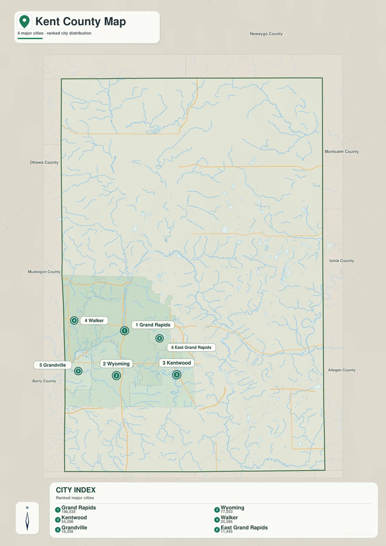
All six ranked major cities cluster within the southern Grand Rapids metropolitan area
The ranked-city map highlights Grand Rapids, Wyoming, Kentwood, Walker, Grandville, and East Grand Rapids. Rather than being scattered evenly across Kent County, all six are concentrated in the southwest and south-central area. Grand Rapids forms the central reference, Wyoming and Kentwood extend southward, Walker occupies the west, Grandville lies to the southwest, and East Grand Rapids sits close to the eastern side of the core.
No connector lines are drawn between the city markers, so this view is not intended to compare straight-line or driving distances. Its strength is distribution: it shows immediately that the largest ranked cities belong to one metropolitan cluster and that the northern half of the county has no city marker in this six-place index. For places such as Rockford, Cedar Springs, Lowell, Sparta, or Kent City, the general road map provides the necessary detail.
Kent County’s official overview describes the county as being in the heart of West Michigan and notes that it contains 21 townships, five villages, and nine cities. The six-city index therefore represents only the major ranked cities shown in this map series, not every incorporated community in the county. Read together with the general map, it is a quick way to separate the densely urban southwest from the much broader rural and small-city landscape to the north and east.
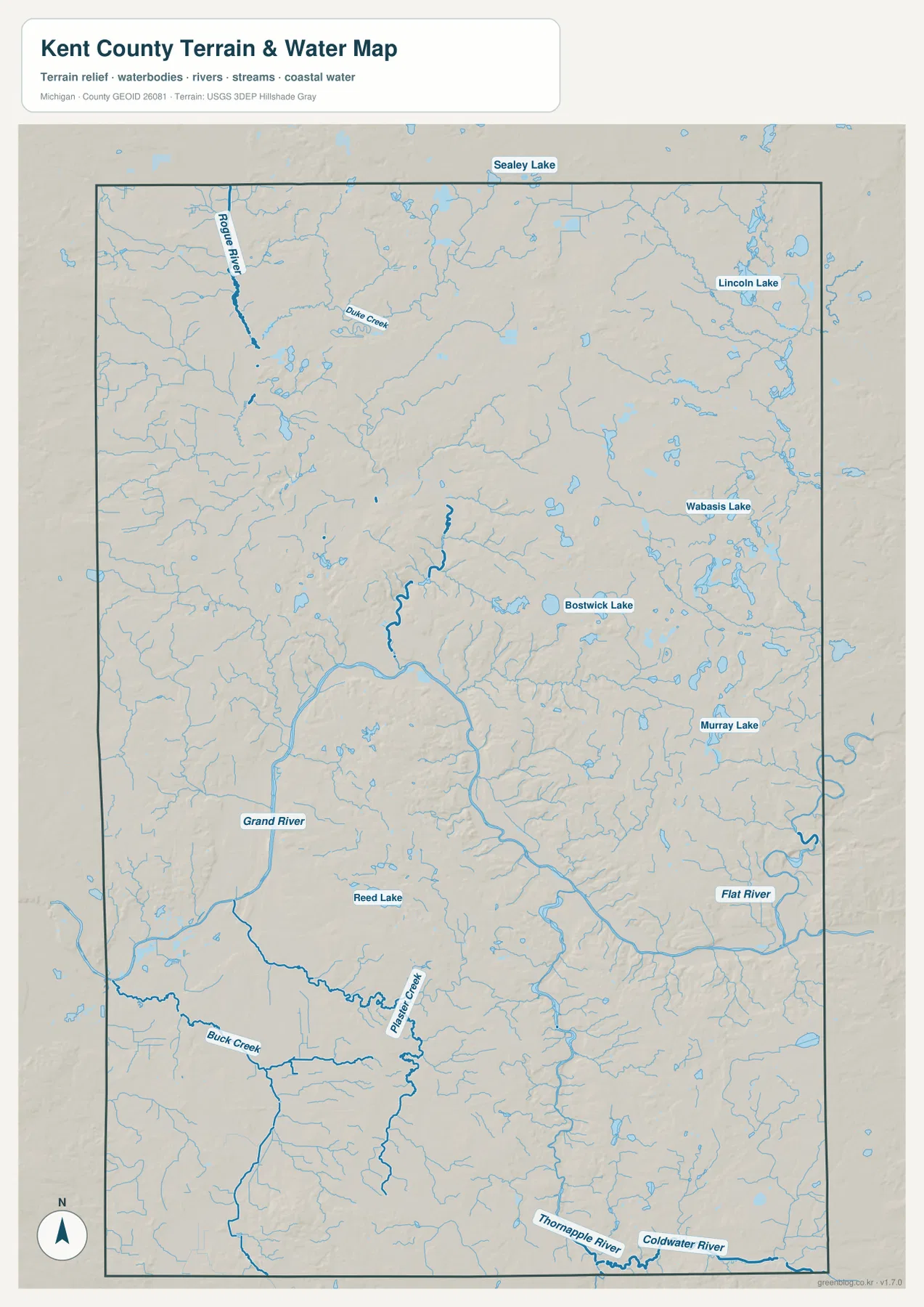
The Grand River ties together the metro lowlands, while Rogue, Flat, and Thornapple rivers define outer areas
The Grand River is the dominant water feature on the terrain-and-water map. It enters the western side of the county, bends through the Grand Rapids area, loops across the center, and then continues toward the eastern boundary. Its broad valley is one of the strongest geographic features in Kent County and provides a natural reference that cuts across city and township lines. Kent County’s Millennium Park sits along this river and spans portions of Grand Rapids, Walker, Grandville, and Wyoming, reinforcing how closely the river and metropolitan area are connected.
Different tributaries identify the outer parts of the county. Rogue River descends through the northwest, with Duke Creek and smaller streams nearby. Flat River appears along the eastern side before joining the wider Grand River system, while Thornapple River crosses the southeast. Coldwater River is visible near the southeastern edge. Around the urban area, Plaster Creek south of Grand Rapids and Buck Creek farther southwest provide smaller-scale landmarks within the same larger drainage network.
The northern and eastern portions also contain numerous lakes. Lincoln Lake and Wabasis Lake are prominent in the northeast, Sealey Lake lies near the northern edge, and Bostwick Lake and Murray Lake provide useful references closer to the east-central and southeastern areas. Reed Lake appears farther south near the metro region. These water bodies are separated across a broad area rather than forming one continuous lake district, so individual lake names can be useful when narrowing down rural locations.
This map is a geographic water reference rather than a flood, navigation, access, or fishing-regulation product. River levels, flood conditions, public access, and boating rules can change and may require much more detailed information. For those purposes, current USGS and Michigan agency resources should take priority. Here, the useful task is to understand where the major rivers and lakes lie relative to roads, cities, and the county boundary.
Elevation rises away from the Grand River corridor and reaches broad uplands in the northeast
The elevation map reports an actual range of approximately 179 to 325 meters and a mean of about 242 meters. The lowest terrain appears in green and follows the Grand River corridor through the central and southwestern parts of the county. The Grand Rapids area occupies much of this lower landscape, and the river’s large bends are easy to recognize because the green valley shape closely matches the water map.
Higher ground becomes much more prominent toward the northeast. Tan and brown terrain covers broad areas east and northeast of the central river valley, with multiple ridges and dissected slopes rather than one smooth plateau. North of Rockford and east of Cedar Springs, the terrain is generally higher than the main Grand River lowland. Small tributaries cut through these uplands, creating narrow lower corridors between hills.
The northwest is more mixed. Rogue River occupies a green low corridor, but rolling terrain rises on both sides and forms a sequence of moderate hills. The southeast also contains alternating low river valleys and higher ground around the Thornapple and Coldwater drainage. This means Kent County is not simply low in the south and high in the north; its relief is organized largely around major river valleys with uplands rising between them.
The 179- and 325-meter endpoints summarize the countywide range shown by the elevation surface. They are not precise elevations for individual buildings, roads, or parcel corners, and the shaded relief is not a substitute for engineering or survey data. Construction, drainage design, detailed grading, and site-specific slope analysis require original elevation datasets or professional surveying. For general orientation, however, the map clearly shows the contrast between the Grand River lowlands and the northeastern uplands.
Different landmarks work best in the metro area, northern towns, and river country
Within the Grand Rapids metropolitan area, city names and highways are the quickest references. Grand Rapids, Walker, Wyoming, Kentwood, Grandville, and East Grand Rapids are close enough that US-131, M-6, and M-21 help separate one side of the urban cluster from another. The airport east of Kentwood is another useful landmark when working with the southeastern metro area.
Farther north, a combination of towns and water features is more effective. Rockford and Cedar Springs establish the US-131 corridor, while Sparta and Kent City identify the northwest. Rogue River adds a natural reference in that same part of the county. In the northeast, Lincoln Lake and Wabasis Lake can be more recognizable than small road names, particularly when a rural destination is described by a lake or nearby recreation area.
The Grand River itself is especially useful for connecting the road, water, and elevation maps. Once its large central bend is located, the elevation view shows the same route as a low green corridor. Moving northeast from that valley brings a clear transition into higher terrain. This comparison helps explain why locations that are not far apart on a political map can sit in noticeably different local landscapes.
The browser images are convenient for quick reference, while the ZIP contains high-resolution JPG copies of the supplied map themes for closer viewing and printing. Use the general map for roads and communities, the ranked-city map for metropolitan concentration, the water map for rivers and lakes, and the elevation map for broad relief. Legal boundaries, current road conditions, flood hazards, and survey elevations still require the latest authoritative data.
Frequently Asked Questions
Where is the main urban concentration in Kent County?
The main urban concentration is in the southwest around Grand Rapids. The ranked-city map places Grand Rapids, Wyoming, Kentwood, Walker, Grandville, and East Grand Rapids within the same broad metropolitan cluster. Rockford, Cedar Springs, Sparta, Kent City, and Lowell are farther from that core and are easier to locate on the general county map.
Which rivers and lakes are most useful for orienting the outer parts of Kent County?
Grand River is the central reference, but Rogue River is useful in the northwest, Flat River in the east, and Thornapple River in the southeast. Lincoln Lake, Wabasis Lake, Bostwick Lake, Murray Lake, and Sealey Lake help distinguish rural parts of the northern and eastern county. Plaster Creek and Buck Creek provide smaller references closer to the metropolitan area.
What files are included in the Kent County map ZIP?
The ZIP contains four high-resolution JPG files: the general county map, ranked-city distribution map, terrain-and-water map, and elevation map. Each image is 2572×3638 px and is better suited to close zooming or printing than the browser version. The water map is not a flood or navigation product, and the elevation map is not survey-grade.
Map File Information
Download the map files associated with this page for reference, printing, and compatible visual projects.
- Included Files: Use only the versions confirmed in the article and supplied images
- File Type: Use the confirmed download contents
- Intended Use: Printing, education, presentations, and map-based projects
Related Maps
Sources and references
Use the following official sources for additional Kent County information and authoritative boundary, hydrography, and elevation data. The maps on this page are designed for county-scale geographic reference; legal boundaries, current water conditions, engineering elevations, and other precision uses should be checked against the latest source data from the responsible agency.
- Kent County: About – official county overview and local-government context
- Kent County Millennium Park – official information for a major Grand River park spanning several metro communities
- U.S. Census Bureau TIGER/Line Shapefiles – county boundary and geographic data
- USGS National Hydrography – river, stream, lake, and hydrographic data
- USGS 3D Elevation Program – elevation data
Green Map creates custom-edited map images using open geographic data sources such as geoBoundaries, Natural Earth, OpenStreetMap, and government open data. These maps are edited visual materials, not raw data files, and are provided for education, documents, presentations, and graphic reference.