Allegan County stretches across western Michigan from the Lake Michigan shore to a broad inland landscape of small cities, rivers, lakes, and rolling terrain. Holland appears at the northwestern edge, Allegan sits near the middle of the county, Wayland lies to the east, and Otsego and Plainwell form a close pair in the southeast. US-31 and I-196 organize travel near the lakeshore, while US-131 provides a separate north-south corridor near the eastern side.
This page includes four views of the county: a general map for boundaries, roads, and named places; a city-distribution map highlighting six major communities; a terrain-and-water map for Lake Allegan, the Black River branches, the Rabbit River system, and the Gun River; and an elevation map showing the contrast between lower western and river corridors and higher inland ground. The original high-resolution JPG versions of all four maps are available together in one downloadable ZIP.
The county makes more sense when the shoreline, central waterways, and eastern uplands are considered together. Holland, Saugatuck, Douglas, and Fennville relate strongly to the western road network and Lake Michigan side. Allegan is tied to the central Lake Allegan corridor and several state routes, while Wayland, Dorr, Martin, Otsego, and Plainwell are better understood in relation to US-131 and the eastern half of the county.
Table of Contents
Two north-south road corridors frame Allegan County
The general county map is anchored by Lake Michigan on the west. Saugatuck and Douglas sit close to the shore, Holland touches the northwestern edge, and Fennville lies slightly inland. US-31 runs north-south through the western side and connects with the I-196 corridor, creating a clear transportation reference for the communities nearest the lake.
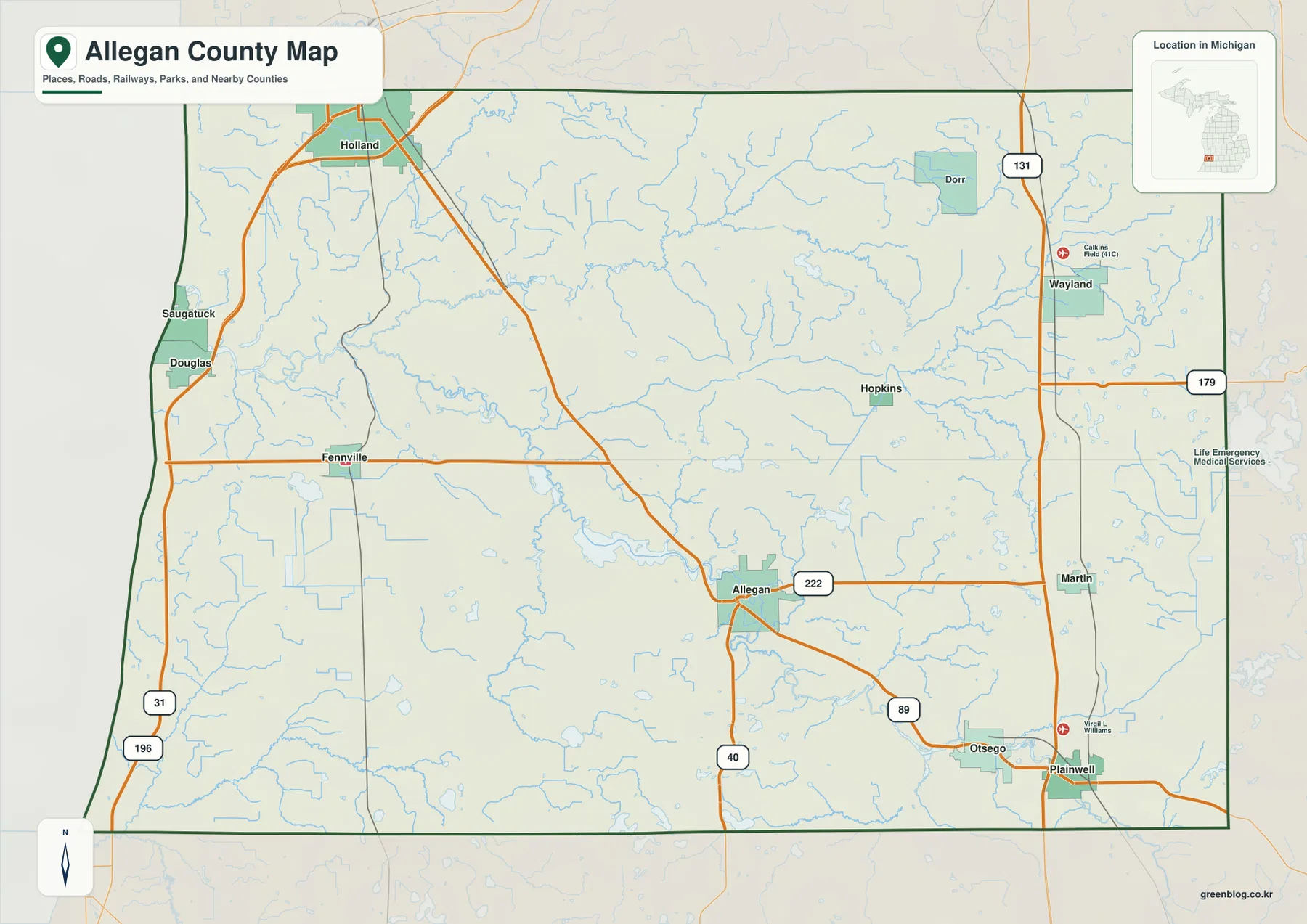
A second north-south framework appears near the eastern boundary, where US-131 passes Wayland and continues toward Martin and Plainwell. The distance between US-31 and US-131 is a useful reminder that Allegan County covers a broad east-west area. Dorr, Hopkins, Allegan, and other communities sit between these two corridors rather than along a single continuous urban strip.
Allegan is slightly south of the county’s center and works as a practical reference for the middle of the map. M-40 runs through this area, M-222 extends eastward, and M-89 leads toward Otsego and Plainwell. Those roads give the central part of the county a branching pattern, with different routes connecting the western lakeshore side, the county seat area, and the southeastern communities.
The northern interior is more dispersed. Dorr and Wayland are toward the east, while Hopkins sits farther southwest. M-179 crosses the northeastern portion and meets the US-131 corridor, providing an east-west reference above Allegan. The road pattern becomes easier to understand when these named communities are used as anchors instead of trying to follow every minor road at once.
Fennville is a useful western inland reference between the lakeshore communities and Allegan. The map shows how routes from the Saugatuck-Douglas area, Fennville, and central Allegan converge without forming one straight corridor. That distinction matters for broad orientation, although current travel times, closures, and navigation should come from live transportation sources rather than this static image.
Neighboring counties appear outside the green Allegan County outline, including Ottawa, Kent, Barry, Kalamazoo, and Van Buren. Those labels provide regional context, but the map is not a legal parcel or survey product. For precise administrative boundaries or property work, use official county GIS and U.S. Census boundary data.
Six highlighted cities show a dispersed settlement pattern
The city-distribution map simplifies the background and marks six communities with ranked labels. Holland is number 1 at the northwestern edge, Allegan is number 2 near the center, Wayland is number 3 in the east, Otsego and Plainwell are numbers 4 and 5 in the southeast, and Fennville is number 6 in the west. Their spacing shows that the county’s major communities are spread across several different parts of the map.
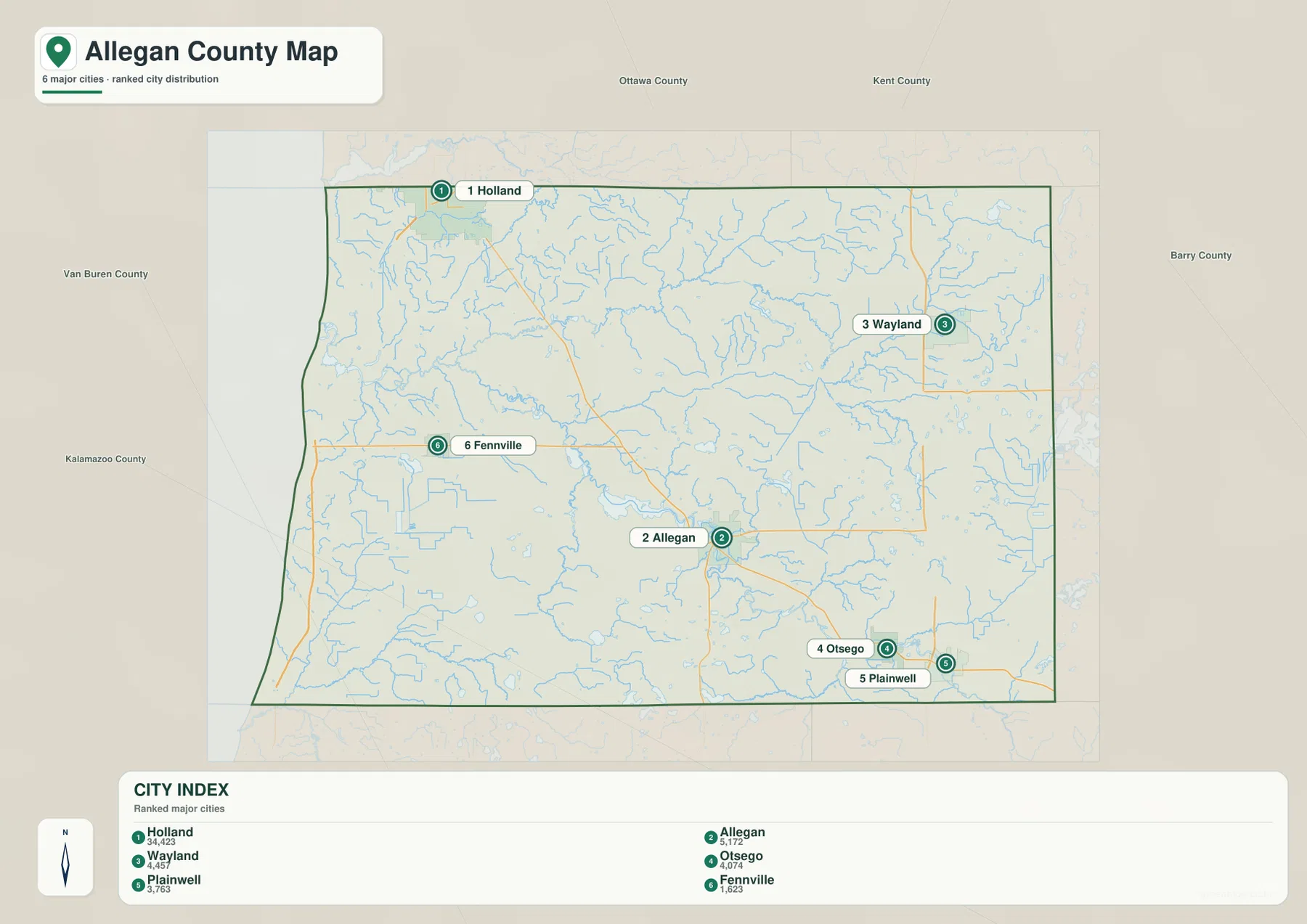
The CITY INDEX on the map lists reference values of 34,423 for Holland, 5,172 for Allegan, 4,457 for Wayland, 4,074 for Otsego, 3,763 for Plainwell, and 1,623 for Fennville. These figures are best treated as the values used for the map’s ranking rather than as guaranteed current population counts. For current demographic figures, consult the latest U.S. Census Bureau data.
Holland is positioned against the northwest edge rather than deep inside the county. That placement is important because the city extends across the county boundary area and functions differently from Allegan, which is surrounded by more of the county’s interior. Wayland, by contrast, is closely associated with the eastern US-131 corridor, making it a useful eastern reference point.
Otsego and Plainwell appear close together in the southeast. The general map adds the M-89 and US-131 context around them, while the city map removes most road detail and makes their proximity easier to see. Fennville stands apart on the western side, helping illustrate how the county’s settlement pattern reaches from the Lake Michigan side to the southeast without a single dominant line of cities.
This map is not a complete inventory of Allegan County communities. Dorr, Hopkins, Martin, Saugatuck, Douglas, and other places visible on the general map are not all included as ranked city markers. Use the city view for quick comparison of the highlighted communities, and switch to the general map when smaller towns or specific roads matter.
No driving distance or travel time is encoded by the spacing of the markers. The straight visual separation between Holland and Allegan, or between Wayland and Otsego, should not be treated as a route measurement. Road choice and current conditions determine actual travel, so the city map works best as a geographic overview.
Lake Allegan links a dense network of rivers and smaller lakes
The terrain-and-water map shifts attention away from highways and toward the county’s drainage pattern. Lake Allegan is the largest inland water feature in the central-western portion of the map. To the west and southwest, several Black River branches are labeled; to the northeast, the Little Rabbit River and Rabbit River stand out; and the Gun River forms a strong water reference in the southeast.
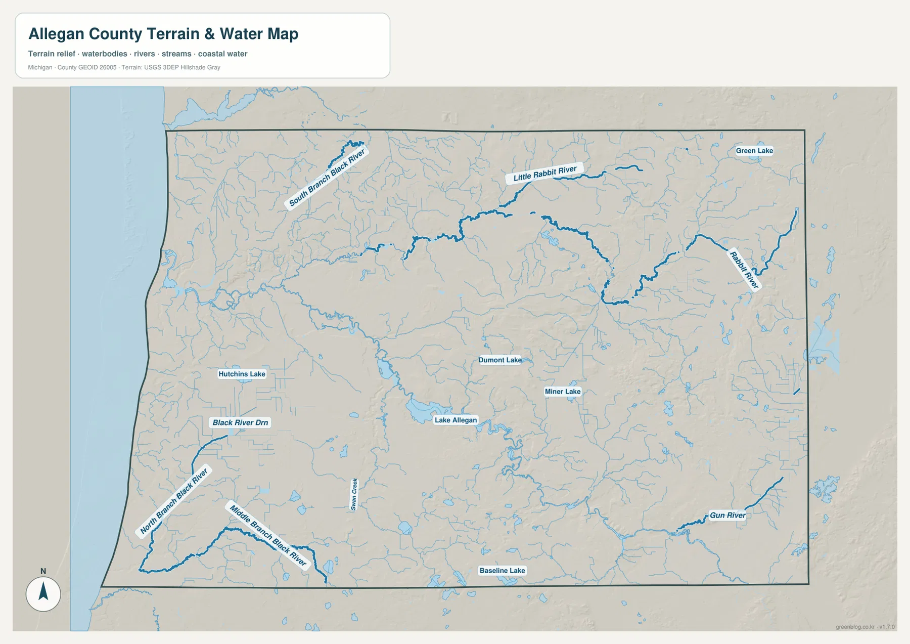
Lake Allegan occupies a broad low corridor west of the county’s center. Water continues away from the lake through connected river valleys, giving the Allegan area a noticeably different natural structure from the higher eastern side. On the general map, roads and place names dominate this same area; on the water map, the lake and its surrounding drainage corridors become the main organizing features.
The western and southwestern areas contain North Branch Black River, Middle Branch Black River, Black River Drain, and other smaller channels. South Branch Black River appears farther north. These separate labels show that the Black River system is not a single uninterrupted line on the map. Hutchins Lake adds another inland water reference away from the Lake Michigan shoreline.
In the northeast, the Rabbit River and Little Rabbit River cross an area filled with small tributaries. Their locations help explain why the Wayland and Dorr side of the county still has a dense water network despite being far from Lake Michigan. The map emphasizes the main channels while also showing many finer blue lines that branch through the surrounding landscape.
The southeast is marked by the Gun River, while Dumont Lake and Miner Lake appear closer to the central-southern area. Baseline Lake is near the southern boundary and Green Lake is labeled in the northeast. These waters differ greatly in size, so line thickness and color should not be used to infer streamflow, depth, or recreational access.
This is not a flood map, navigation chart, water-quality map, or legal access map. Anyone making decisions about boating, fishing, flood risk, or regulated water use should consult the appropriate current Michigan and federal sources. The value of this image is in showing where the named rivers, lakes, and low corridors sit relative to one another.
Comparing the water map with the road map also clarifies why some routes bend around low ground and why several communities are separated by broad drainage areas. Lake Allegan, the Black River branches, and the eastern rivers occupy natural corridors that influence the visual structure of the county even when those waterways are not the first features noticed on a standard road map.
Lower Lake Michigan and river corridors contrast with eastern uplands
The elevation map removes most labels and uses locally scaled color and shaded relief. Its legend notes an actual data range of about 177 to 306 meters with a mean of 217 meters. Greens represent lower terrain within Allegan County, while yellow and brown tones represent relatively higher ground. The scale is designed for this county, so the same color on another county’s map may correspond to a different elevation.
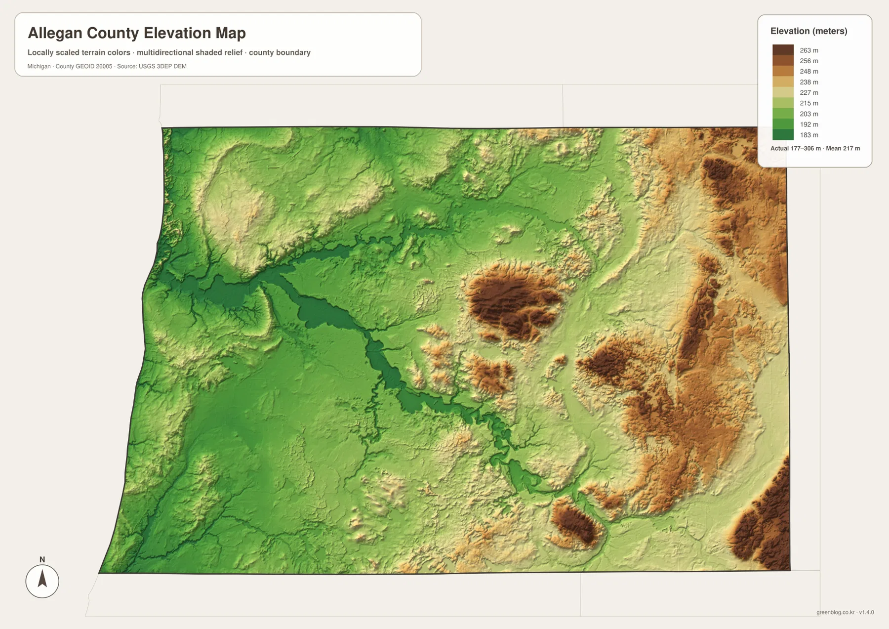
The lowest-looking areas occur along the Lake Michigan side and through the broad central water corridor around Lake Allegan. A dark green band follows the lake-and-river system westward, making the connection between water and lower terrain especially clear. Moving inland does not produce a smooth, uniform rise because river valleys continue to cut through higher surrounding ground.
Higher yellow and brown terrain becomes more common toward the east, particularly in the northeastern and southeastern sections. When the general map is kept in mind, these higher zones correspond broadly to the inland side near Wayland, Dorr, Martin, and the US-131 corridor. The colors show a regional pattern, not an exact elevation for any one road intersection or building site.
Several isolated higher hills also appear in the center. Brown and tan patches north and east of Lake Allegan, along with smaller raised areas farther south, interrupt the lower valleys. This pattern makes the county look more varied than a simple coastal plain. The water map helps explain the green corridors that wind between these uplands.
The western side is not uniformly flat either. The Lake Michigan edge is generally low, but inland ridges and rolling terrain appear behind it. Around the Saugatuck-Douglas-Fennville side, lower coastal ground transitions into more uneven inland relief. This is one reason the elevation map adds information that cannot be read from road lines alone.
The displayed surface is a generalized visual reference, not survey-grade measurement. Construction, engineering drainage, flood-elevation work, or detailed slope calculations should use the underlying USGS 3D Elevation Program data or another authoritative high-resolution source. The map is best for explaining broad differences across the county.
For classroom comparison, start by locating Holland, Allegan, and Wayland on the general map, then switch to the elevation view. Even without place labels, the low Lake Michigan side, the Lake Allegan corridor, and the higher eastern terrain remain distinct. Adding the water map shows how many rivers and lakes occupy the lower portions of that relief.
Choosing the most useful Allegan County map
Use the general county map when roads and named places are the priority. It combines Holland, Saugatuck, Douglas, Fennville, Allegan, Wayland, Otsego, Plainwell, US-31, I-196, US-131, M-40, M-89, and several other routes in one view. It is the strongest starting point for regional orientation and broad trip planning.
Use the city-distribution map when the presentation needs to stay simple. With only six highlighted communities, it makes the county’s west-center-east pattern easier to explain without the visual weight of every road and stream. It is not a complete settlement map, so the general map remains necessary for Dorr, Hopkins, Martin, Saugatuck, Douglas, and other places.
Use the terrain-and-water map for Lake Allegan, the Black River branches, the Rabbit River system, the Gun River, and the county’s many smaller lakes and streams. The shaded relief adds useful context, but the map does not provide flood zones, navigation information, water depth, or legal access conditions.
Use the elevation map when the main question concerns lower lakeshore and river corridors versus higher inland terrain. Its color pattern makes the western lowlands, central drainage corridor, and eastern uplands easy to compare. Exact elevations and slope measurements should come from the official source data rather than estimated colors.
The WebP images on this page are optimized for quick viewing. The ZIP below contains the original high-resolution JPG versions of all four supplied maps, which are better suited to printing, large displays, classroom handouts, and presentations where additional image detail is useful.
Frequently Asked Questions
Which map is best for locating Holland, Allegan, Wayland, and the main highways?
Use the general county map. It shows US-31 and I-196 on the western side, M-40 and M-222 around Allegan, and US-131 near Wayland and the eastern edge. It is well suited to regional orientation, while current driving directions and traffic conditions should come from live transportation or navigation sources.
Which map should I use to compare Lake Allegan, the Black River, Rabbit River, and Gun River?
Use the terrain-and-water map. It emphasizes Lake Allegan in the central-western area, the Black River branches in the west, the Rabbit River system in the northeast, and the Gun River in the southeast. It is a geographic reference rather than a flood, depth, navigation, or water-quality product.
Which parts of Allegan County appear higher on the elevation map?
The Lake Michigan side and the central Lake Allegan corridor appear relatively low, while higher terrain is more common in the eastern and some interior sections. The legend reports an actual range of roughly 177 to 306 meters, but exact site elevations should be checked in authoritative elevation data rather than estimated from color alone.
Map File Information
The ZIP contains the high-resolution JPG originals for the Allegan County general map, city-distribution map, terrain-and-water map, and elevation map described on this page.
- Included Files: general county map, city-distribution map, terrain-and-water map, elevation map
- File Type: JPG
Related Maps
Sources and reference links
For county government and local services, see the official Allegan County website. For the underlying types of boundary, hydrography, and elevation information used in county mapping, consult U.S. Census Bureau TIGER/Line, USGS National Hydrography, and the USGS 3D Elevation Program. These page maps are general reference products and do not replace legal boundaries, survey data, navigation charts, or flood determinations.
Green Map creates custom-edited map images using open geographic data sources such as geoBoundaries, Natural Earth, OpenStreetMap, and government open data. These maps are edited visual materials, not raw data files, and are provided for education, documents, presentations, and graphic reference.