Baltimore County wraps around much of independent Baltimore City and then expands far to the north, west, and east. The landscape changes noticeably from Cockeysville and the broad northern uplands to the suburban belt around Towson, Pikesville, and Owings Mills, then to Essex, Middle River, Dundalk, and the Chesapeake-facing southeast. This page explains the county boundary and road pattern, the supplied city index, the major rivers and coastal water, and the elevation change across the county. High-resolution JPG versions of the maps are also available together in a downloadable ZIP archive.
Baltimore County Council states that there are no incorporated towns, villages, municipalities, or other political subdivisions within the county. Place labels such as Towson, Cockeysville, Essex, and Dundalk are therefore best read as community and geographic references rather than a list of separate municipal governments. Towson is the county’s governmental center and provides a convenient anchor just north of Baltimore City for understanding the surrounding suburban areas.
Table of Contents
Towson makes the county’s wraparound relationship with Baltimore City easy to see
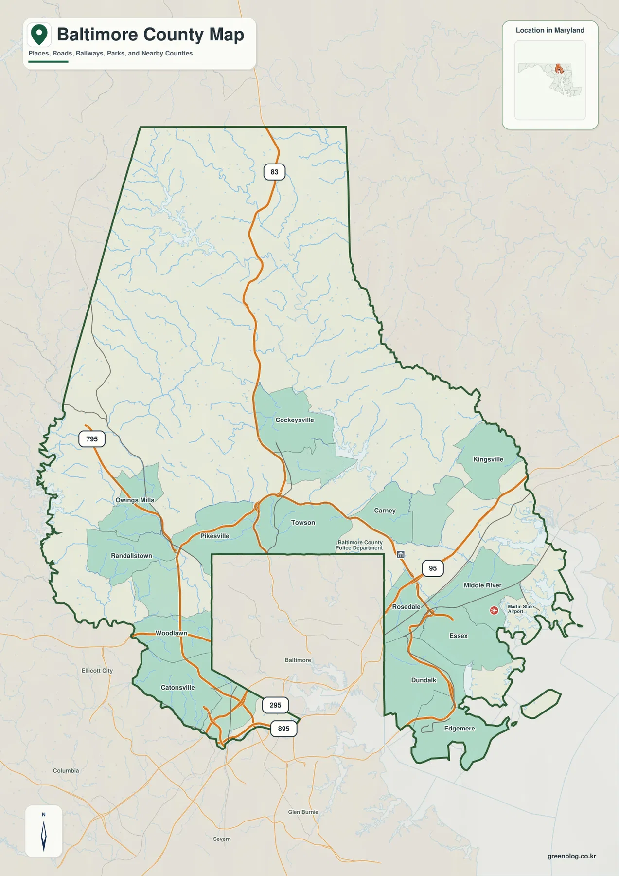
The most distinctive feature of the general map is the separate Baltimore City area cut out of the county’s south-central portion. Baltimore City and Baltimore County are different jurisdictions even though they share the same regional name. The county boundary follows the city’s north, west, and east sides before extending toward the Chesapeake-facing southeast, so communities such as Pikesville, Towson, and Rosedale can be very close to the city while still lying in Baltimore County.
Towson appears immediately north of Baltimore City. Pikesville and Owings Mills sit to the west, with Randallstown, Woodlawn, and Catonsville farther southwest. Cockeysville provides a strong reference north of Towson, where settlement labels become less concentrated and streams are more numerous. The western boundary also stretches a long distance northward, making the upper and western parts of the county much more extensive than the dense suburban areas near the city.
On the eastern side, Carney leads toward Kingsville and the broader northeastern interior. Farther southeast, Rosedale, Middle River, Essex, Dundalk, and Edgemere occupy a landscape increasingly shaped by tidal water and inlets. Martin State Airport is labeled near Middle River and provides another useful coastal reference. This part of the boundary is much more irregular than the northern interior because rivers and Chesapeake Bay water cut deeply into the land.
The general map is not designed to label every neighborhood street. Its strongest use is countywide orientation: understanding the outline, the major communities, and their position relative to Baltimore City. On a small printout, begin with Towson, Cockeysville, Pikesville, Essex, and the dark county boundary, then use the high-resolution file when smaller roads or waterways need closer inspection.
I-83, I-795, and I-95 organize three different sides of the county
I-83 is the clearest highway reference in the north-central part of Baltimore County. It passes through the Cockeysville side and continues south toward Towson and Baltimore City. The surrounding terrain contains many streams and rolling ridges, but the interstate provides a simple line for understanding how the northern interior connects with the denser suburban area closer to the city.
On the western side, I-795 runs near Owings Mills and approaches the Pikesville area. Randallstown, Woodlawn, and Catonsville occupy the county’s western and southwestern edge around Baltimore City, where the city-county boundary is never far away. MD 295 and I-895 are also labeled farther south, helping place the transportation corridors that pass near the lower edge of the city and county.
I-95 is the strongest eastern highway label, passing through the Rosedale and Middle River side before continuing northeast. The closer the map gets to Essex, Dundalk, and Edgemere, the more the road network must work around creeks, river mouths, and shoreline. Kingsville, by contrast, sits farther inland, showing how different the northeastern and southeastern parts of the same county can look.
This road layer is intended for orientation rather than live navigation. Construction, congestion, closures, and current routing can change on I-83, I-795, I-95, MD 295, and I-895. Actual travel should be checked with Maryland transportation information and a current navigation service, especially for routes that pass through or around Baltimore City.
The Baltimore marker on the City Index is a regional reference, not a municipality inside the county
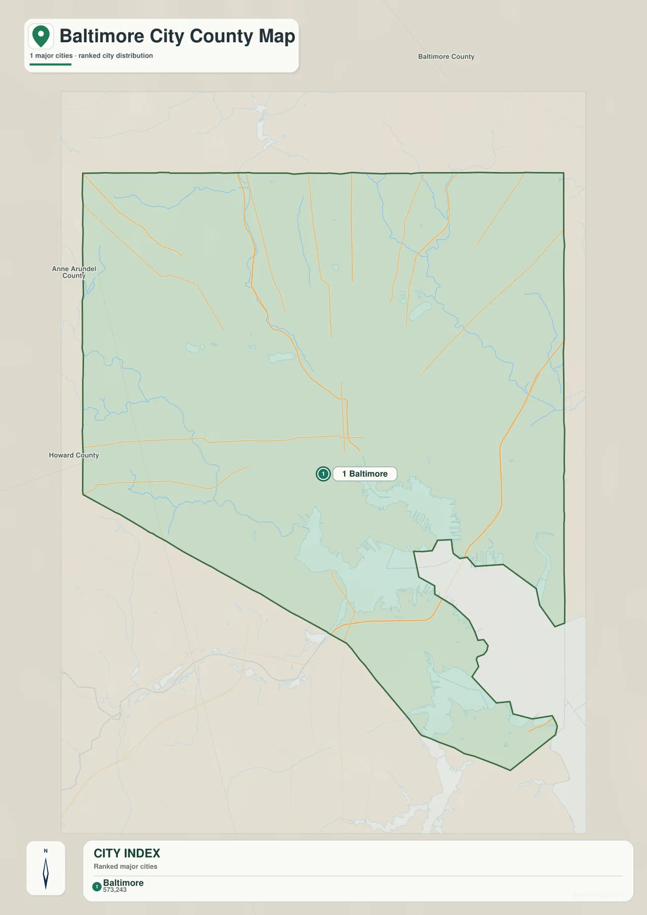
The supplied City Index places Baltimore in the number-one position and prints the figure 573,243 in the lower index. That label requires context: Baltimore City is an independent jurisdiction and is not part of Baltimore County. The marker is therefore best treated as a regional reference to the major city surrounded by the county, not as evidence of an incorporated city within Baltimore County.
The Baltimore County Council specifically notes that the county has no incorporated towns, villages, or municipalities. A traditional city-ranking graphic is therefore less informative here than it would be in a county with several incorporated cities. To understand the county itself, community labels such as Towson, Cockeysville, Pikesville, Owings Mills, Essex, and Dundalk on the general map provide much more useful geographic detail.
The figure 573,243 also lacks a stated reference year and statistical definition on the supplied image. It should not be presented as a current population count in this article. Current population figures for Baltimore City or Baltimore County should be taken from the latest U.S. Census Bureau data rather than inferred from the map index.
The simplified graphic is still useful for showing the overall county outline and the position of Baltimore City within the regional geography. The large cutout in the south-central part corresponds to the independent city, while Baltimore County continues around it. No connector distances are provided, so route mileage and travel time should be determined with the road map and a current routing service.
Little Gunpowder River, Gwynns Falls, and Patapsco River divide the county into distinct watersheds
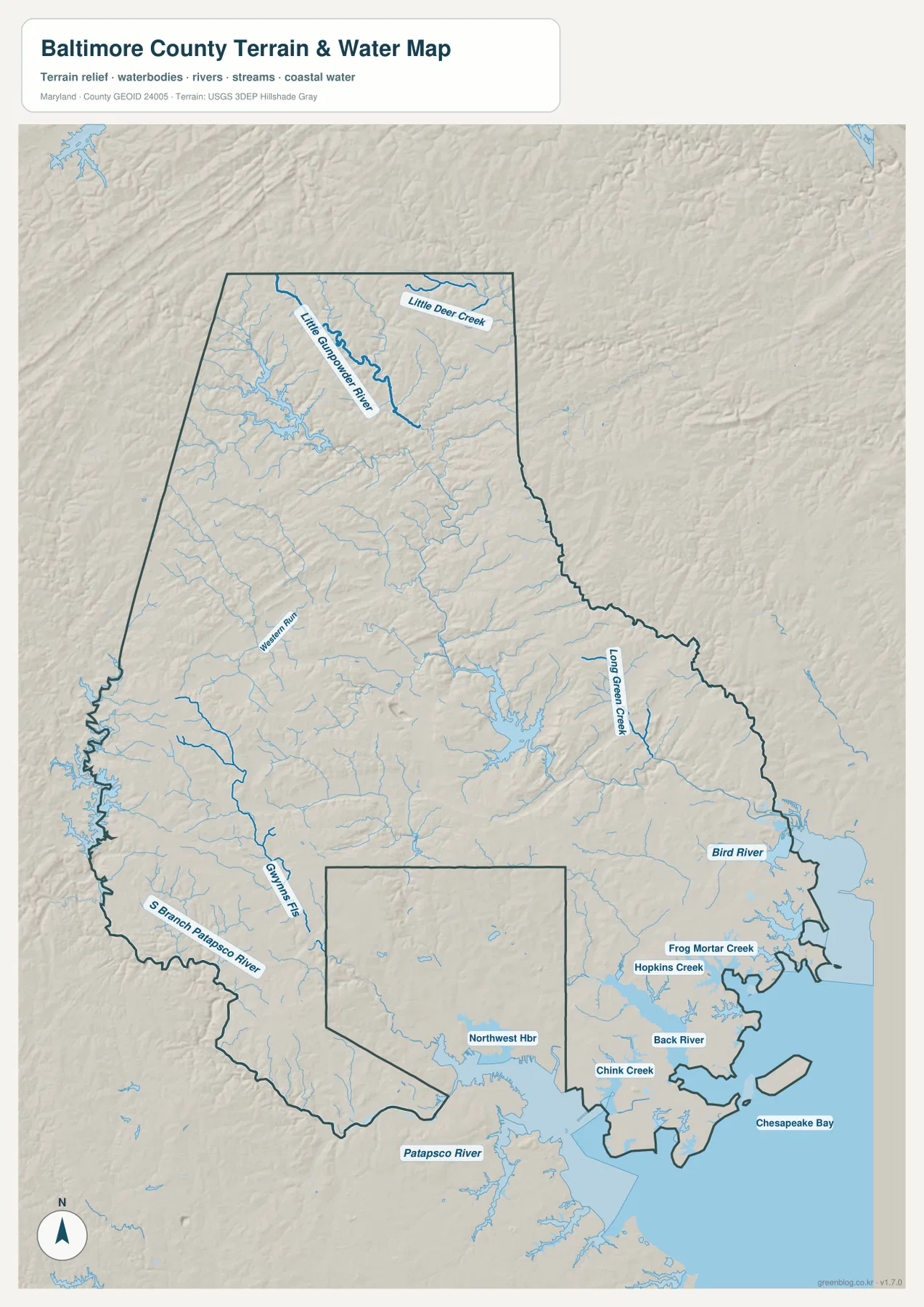
The terrain-water map makes the northern stream network especially clear. Little Gunpowder River is one of the strongest labels in the upper county, with Little Deer Creek nearby. Western Run appears farther west. Numerous smaller tributaries fill the spaces between them, reflecting a more deeply dissected upland landscape than the low coastal terrain in the southeast.
In the west and southwest, Gwynns Falls and the South Branch Patapsco River provide two important references. Gwynns Falls approaches the western side of Baltimore City, while the Patapsco system follows the Howard County-facing side of the county. Comparing this map with Woodlawn and Catonsville on the general map shows how many stream corridors pass through the western suburban landscape.
Farther east, Long Green Creek and Bird River stand out before the map reaches Frog Mortar Creek, Hopkins Creek, Back River, and Chink Creek near the coast. These waterways help explain the irregular land around Middle River, Essex, Dundalk, and Edgemere. Roads that appear close together on a regional map often have to work around broad creek mouths and tidal water in this part of Baltimore County.
Patapsco River and Northwest Harbor dominate the southern water view, and Chesapeake Bay opens to the east. This map is a geographic reference, not a flood map or nautical chart. It does not provide channel depth, tides, navigation restrictions, real-time river levels, or flood probability. Boating and flood-safety decisions require current NOAA, FEMA, USGS, Maryland, or local agency products.
Elevation rises sharply toward the northwestern uplands and falls toward Chesapeake Bay
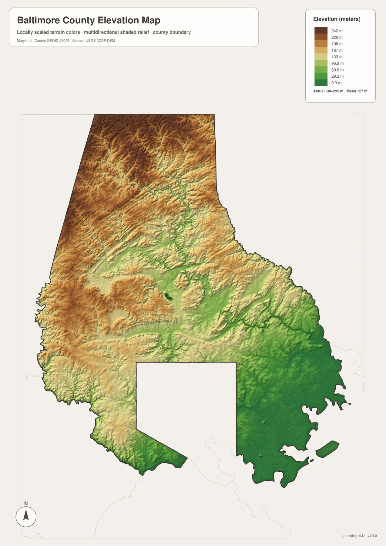
The elevation graphic reports an actual range of -30 to 295 meters and a mean elevation of 127 meters for Baltimore County. The locally scaled colors show the broad pattern clearly: browns and tans dominate the northwestern and northern uplands, while greener low-elevation areas spread toward Towson and especially the southeastern Chesapeake side. The county is therefore much more topographically varied than its suburban image alone might suggest.
The northern terrain is broken by repeated stream valleys. Little Gunpowder River and Western Run occupy lower corridors between higher ridges, and similar relief continues through the central county. Comparing the elevation and water maps makes those relationships easier to see because the stream network consistently follows lower terrain between the uplands.
Elevation decreases toward the east and southeast, where Essex, Middle River, Dundalk, Back River, and Chesapeake Bay occupy much lower terrain. The difference between these green coastal areas and the higher northwest is one of the strongest patterns on the elevation map. It also helps explain why the county contains both rolling inland landscapes and broad low-lying tidal areas.
The map is a generalized elevation surface rather than a survey. The printed -30 to 295 meter range should not be applied to a specific property, road, or building without checking authoritative data. Engineering, drainage design, construction, and flood-risk work require detailed elevation information such as USGS 3D Elevation Program data, professional survey measurements, and dedicated flood products.
Use the road, water, and elevation views for different parts of the county
The general county map is the best starting point for Towson, Cockeysville, Pikesville, Essex, and the major highway corridors. It also makes the separate Baltimore City boundary easy to recognize. The City Index is useful only as a simplified regional locator and should not be treated as a list of incorporated municipalities within Baltimore County.
Use the terrain-water map when Little Gunpowder River, Gwynns Falls, Patapsco River, Back River, or Chesapeake Bay is the main subject. The elevation view is better for explaining the contrast between the high northwestern uplands and the low southeastern waterfront. Switching between these layers provides a much clearer understanding of how roads, communities, streams, and terrain fit together.
The downloadable originals are JPG files measuring 2572 × 3638 pixels each. They work well in full-page documents and can be enlarged around a specific part of the county for classroom material, presentations, or personal reference. Enlarging a map does not add live traffic, parcel boundaries, flood zones, nautical depth, or survey-grade elevation, so specialized decisions should always use current official data.
Baltimore County is not simply a suburban ring around Baltimore City. It includes extensive northern uplands, western stream valleys, densely settled central communities, and a low southeastern coast along Chesapeake Bay. Choosing the map that matches the question makes those regional differences much easier to understand.
Frequently Asked Questions
Is Baltimore City part of Baltimore County?
No. Baltimore City is an independent jurisdiction separate from Baltimore County. That is why the county map contains a large cutout around the city, and the Baltimore marker on the City Index should be understood as a regional reference rather than a municipality inside the county.
Why is Towson an important reference point on the Baltimore County map?
Towson is the center of Baltimore County government and sits directly north of Baltimore City. Cockeysville lies farther north, Pikesville and Owings Mills are to the west, and Rosedale and Essex are to the southeast, so Towson is a convenient anchor for understanding the county’s central communities.
Can the -30 to 295 meter elevation range be used for surveying or flood decisions?
No. The range is useful for understanding countywide terrain variation, not for parcel-level surveying or flood-risk assessment. Precise elevations should come from authoritative USGS or professional survey data, and flood decisions should rely on current FEMA and local flood information.
Map File Information
The ZIP archive contains high-resolution JPG maps of Baltimore County matching the map themes described on this page.
- Included Files: county and major roads map, City Index map, terrain and water map, elevation map
- Printable Size: 2572 × 3638 pixels each
- File Type: JPG
Related Maps
Sources and References
- Baltimore County Council – About
- Baltimore County Government – Official Website
- U.S. Census Bureau – TIGER/Line Shapefiles
- USGS – National Hydrography
- USGS – 3D Elevation Program
Green Map creates custom-edited map images using open geographic data sources such as geoBoundaries, Natural Earth, OpenStreetMap, and government open data. These maps are edited visual materials, not raw data files, and are provided for education, documents, presentations, and graphic reference.