De Soto Parish sits in northwestern Louisiana, where Mansfield functions as the most useful reference point for roads, communities, and the parish’s dense network of bayous and small streams. This page brings together a general parish map, a city-distribution map, and a terrain-and-water map so the same area can be read in three different ways. The matching high-resolution JPG files are available in the download box below for printing, classroom use, reports, or personal map collections.
Louisiana’s official parish profile identifies Mansfield as the parish seat and lists communities including Stonewall, Keachi, Logansport, Grand Cane, South Mansfield, Stanley, Frierson, and Kingston. Census geography reports about 876 square miles of land in De Soto Parish. Because those communities are spread over a broad area rather than packed into one continuous urban zone, the roads and waterways are especially helpful for understanding how one part of the parish relates to another.
Table of Contents
Mansfield as the road reference point
On the general parish map, Mansfield occupies a central position and sits close to the meeting of the two most recognizable highways in the area: US 171 and US 84. US 171 runs generally north and south, linking the Stonewall side of the parish with Mansfield and points farther south. US 84 crosses the western half of the parish through the Logansport direction and reaches Mansfield before continuing east. Those two routes make Mansfield a practical anchor for reading the rest of the map, even for someone who has never visited De Soto Parish.
The road network becomes more detailed away from the main highways. LA 5 appears in the western and southwestern part of the parish, LA 509 reaches into the area northeast of Mansfield, and routes such as LA 175, LA 177, LA 346, LA 481, LA 510, LA 512, and LA 513 help connect smaller communities and rural areas. The purpose of the map is not to replace a navigation app, but it does make it easy to see which roads form the broad framework of the parish and which ones serve more local travel.
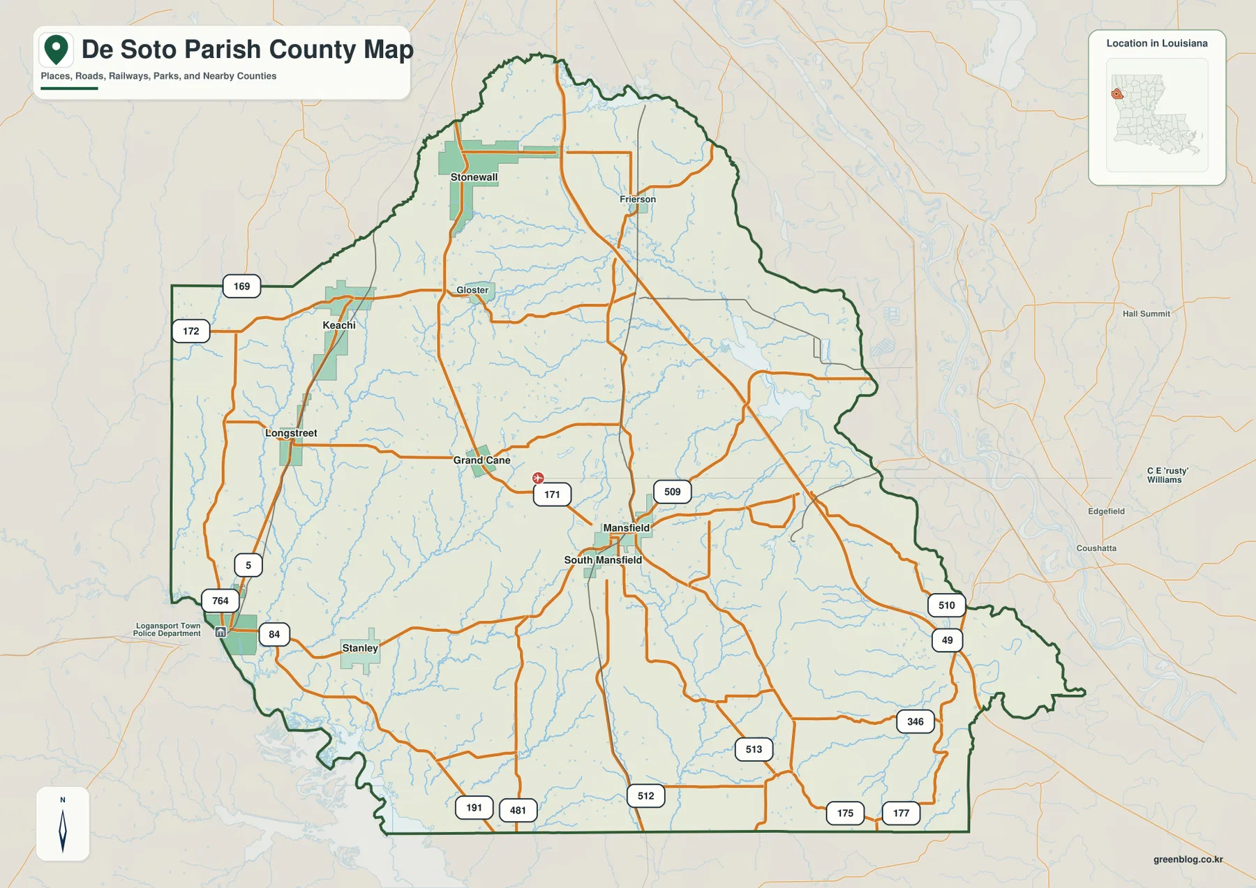
The parish outline is irregular, especially along portions of the eastern and southwestern edges. Census geography identifies De Soto Parish as adjoining Louisiana parishes as well as Shelby and Panola counties in Texas. That cross-state setting matters when reading the western side of the map because communities near the state line can be closer to places in East Texas than the Louisiana statewide map might suggest. The parish map is therefore useful not only for local orientation but also for seeing De Soto Parish in the larger northwest Louisiana border region.
A spread-out pattern of towns and villages
The city-distribution map strips away much of the extra road detail and emphasizes the relative positions of six prominent communities. Mansfield remains near the middle, South Mansfield lies immediately to its south, and Grand Cane sits to the west-northwest. Keachi is farther northwest, while Stonewall is separated from the central cluster by a long stretch of northern parish. Logansport appears near the southwestern edge, giving the map a clear second reference point for the western side.
This arrangement is useful because it shows that the parish is not organized around a single compact chain of adjacent towns. Instead, the named communities are distributed along different corridors. Stonewall is naturally read in relation to the US 171 route, while Logansport aligns with the US 84 corridor. Grand Cane and Keachi help fill in the western interior between those larger reference routes. When a local address or feature is described as being “near Grand Cane” or “north of Mansfield,” this simplified map can make that description much easier to place.
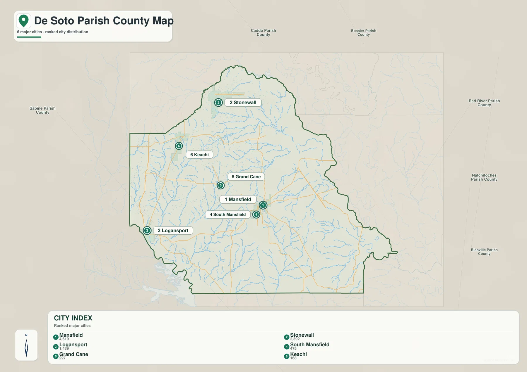
The official Louisiana profile provides useful context for the labels: Mansfield is listed as the city, Keachi, Logansport, and Stonewall as towns, and Grand Cane, South Mansfield, and Stanley as villages. That classification is not the main purpose of the graphic, but it confirms that the place names shown are established local communities rather than arbitrary map labels. The map should still be treated as an orientation graphic rather than a source for legal municipal limits or driving times.
US 171, US 84, and the smaller state routes
For a quick mental picture of De Soto Parish, it helps to think of two broad movements. US 171 provides a north-south reference through the parish, while US 84 provides an east-west reference through Mansfield and toward Logansport. Once those routes are located, smaller roads become easier to interpret. A road that branches east of Mansfield can be compared with LA 509 or the routes reaching toward the southeastern parish, while western roads can be read against the LA 5 and US 84 side of the map.
The general map also shows why rural travel here cannot be reduced to a simple grid. Roads bend around streams, connect dispersed settlements, and change direction as they cross the parish. In printed form, the map works well as an overview sheet because the boundary, primary routes, and town names remain visible together. For detailed turn-by-turn travel, current road conditions, closures, or construction, the Louisiana Department of Transportation and Development should be checked separately.
Rambin Bayou, Clear Lake, and a dense water network
The terrain-and-water map changes the emphasis completely. Instead of making roads the dominant feature, it brings the parish’s many creeks, bayous, ponds, and lakes to the foreground. Rambin Bayou is one of the clearest named waterways in the northern half of the parish. Brushy Bayou and Caney Bayou appear nearby, while Little Bayou La Branche winds through the north-central and northeastern area. Clear Lake and Smithport Lake give the eastern side of that cluster two easy-to-recognize water landmarks.
Farther south, the map labels Jenkins Pond, Frost Pond, and Logan Pond, along with Bayou San Patricio. Castor Creek and Clement Creek help define the western and southwestern water pattern. Between the named features are many smaller tributaries, so the overall impression is one of a finely branched drainage landscape rather than a parish dominated by a single large river channel. The shaded relief under the streams helps separate low valleys from surrounding higher ground, but it is a visual aid rather than survey-grade elevation data.
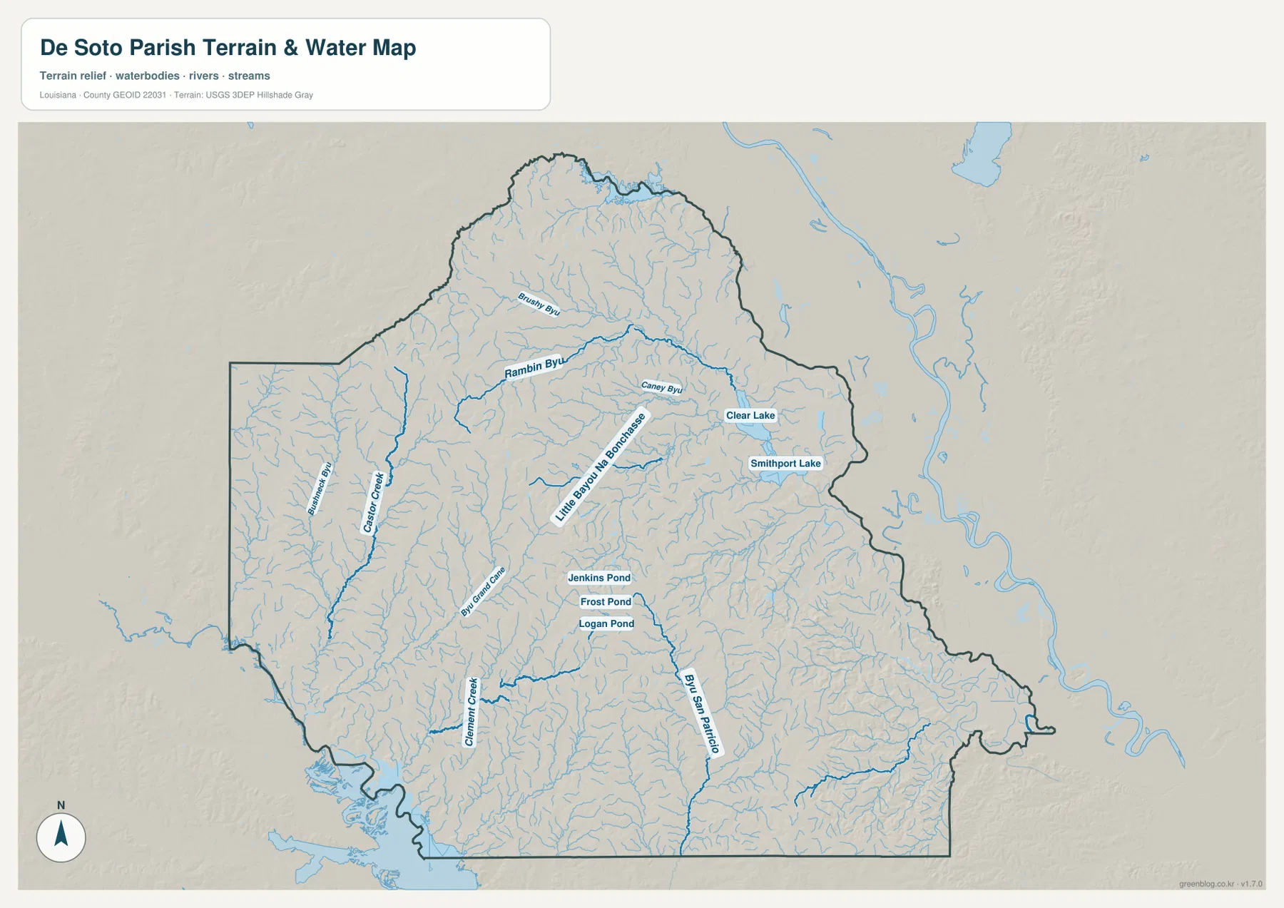
This water map is best used for geographic reference. It can help a reader see which named lakes and bayous lie near one another or why a road corridor may curve through a particular part of the parish. It is not a floodplain map, a navigation chart, a parcel map, or a legal water-boundary document. For current hydrography data, the USGS National Hydrography resources provide the authoritative federal reference.
Reading the three maps together
Each graphic answers a different practical question without requiring the reader to learn specialized GIS terminology. The parish map is the fastest choice for boundaries, roads, and place names. The city map removes distractions so the direction and spacing between communities stand out. The terrain-and-water map explains what lies between those towns by showing the bayous, creeks, ponds, and landform shading that are less obvious on the road-focused view.
A useful way to combine them is to start with a place and then switch maps. Find Logansport on the general map, then compare the southwestern edge on the water map to see how many channels and low areas surround that part of the parish. Locate Stonewall on the city map, then return to the general map to trace the US 171 corridor toward Mansfield. Find Clear Lake on the water map and use Mansfield or nearby road lines on the general map to place it in the wider parish. This back-and-forth approach is often quicker than trying to force every kind of information into one crowded image.
Choosing the right version for print or study
For a report, presentation, or general parish overview, the standard map is usually the best first image because it balances boundaries, roads, and community names. The city map is better when the goal is to explain settlement geography without the visual weight of every smaller road. The terrain-and-water map works best for natural features, classroom discussions about drainage, or any project where bayous and lakes matter more than highway numbers.
The high-resolution JPG files are especially useful when the image needs to be printed or cropped. All three source images use the same 3638 by 2572 pixel dimensions, which makes it easier to place them in the same document layout or slide template. The lighter WebP versions on the page are convenient for quick browsing, while the JPG files preserve more detail for larger output. When printing the water map, a larger page or a close crop is preferable if the small tributary labels need to remain readable.
These maps are reference graphics rather than legal or engineering documents. Property boundaries, official municipal limits, flood zones, surveying measurements, and construction decisions should be checked against the appropriate government source. That distinction is especially important in a parish with many small waterways, where a simple visual line can show the location of a stream without defining its regulatory or legal significance.
Placing De Soto Parish in the northwest Louisiana region
De Soto Parish makes more sense when it is viewed as part of the broader northwest Louisiana border region rather than as an isolated shape. Caddo Parish lies to the north, Red River and Natchitoches parishes are on the eastern side of the regional picture, and the western side approaches the Texas line as well as Sabine Parish. That setting explains why the map contains routes that are important both for movement within the parish and for trips toward neighboring Louisiana and East Texas communities.
Using Mansfield as the center, Stonewall, Logansport, Grand Cane, and Keachi form a set of directional anchors. Once those are familiar, a reader can make sense of many smaller rural locations even when they are not individually labeled. This is one reason a county-level or parish-level map remains useful alongside modern navigation: it provides a broad mental framework that turn-by-turn directions often hide.
When to use the map and when to use official data
The graphics on this page intentionally simplify complex geographic information. They are well suited to orientation, teaching, general research, and visual comparison, but they should not be treated as legal boundary records or engineering measurements. Census TIGER/Line files are a better source for official geographic boundaries, Louisiana DOTD material is appropriate for road-system details, and USGS hydrography is the stronger reference for current named water features.
For ordinary map reading, however, the simplified presentation has an advantage: the important local relationships remain visible without layers of technical detail. A student can see how Mansfield, Stonewall, and Logansport relate to one another, a traveler can recognize the US 171 and US 84 framework, and a reader interested in natural geography can move directly to Rambin Bayou, Clear Lake, and the surrounding tributaries.
Frequently Asked Questions
Which map is best for finding Mansfield and the main highways?
Use the general parish map when you need Mansfield together with US 171, US 84, surrounding towns, and the parish boundary. The city-distribution map is cleaner when you only need the relative positions of Mansfield, Stonewall, Logansport, Grand Cane, Keachi, and South Mansfield.
Where can I see Rambin Bayou and Clear Lake?
Rambin Bayou, Little Bayou La Branche, Clear Lake, Smithport Lake, and many smaller tributaries are easiest to see on the terrain-and-water map. It is intended for geographic reference and should not be used as a flood-zone or navigation map.
What is included in the downloadable ZIP?
The ZIP contains the original high-resolution JPG files corresponding to the three maps displayed on this page: the general parish map, the city-distribution map, and the terrain-and-water map. Each file can be used independently for printing or document layout.
Map File Information
The ZIP contains the original high-resolution JPG files that correspond to the parish map, city distribution map, and terrain-and-water map shown on this page.
- Included Files: parish map JPG, city map JPG, terrain and water map JPG
Related Maps
Sources and references
- Louisiana.gov – DeSoto Parish Profile
- U.S. Census Bureau QuickFacts – De Soto Parish, Louisiana
- U.S. Census Bureau TIGER/Line Shapefiles
- USGS National Hydrography
- Louisiana DOTD – De Soto Parish Highway Map
Green Map creates custom-edited map images using open geographic data sources such as geoBoundaries, Natural Earth, OpenStreetMap, and government open data. These maps are edited visual materials, not raw data files, and are provided for education, documents, presentations, and graphic reference.