Bienville Parish lies in north Louisiana, with Arcadia and Gibsland near the I-20 and US 80 corridor, Ringgold farther southwest, and smaller communities spread across the rural interior. This Bienville Parish Map collection shows Arcadia, Ringgold, Gibsland, Castor, Lucky, Saline, major state highways, Saline Bayou, Black Lake Creek, and the wider network of creeks, lakes, and reservoirs across the parish. High-resolution map files are available for download in the section below.
The package includes three map themes only: a general parish map, a city-distribution map, and a terrain-and-water map. High-resolution JPG versions of all three can be downloaded in one ZIP. Arcadia and Ringgold make practical settlement anchors, while the northern interstate corridor and the Saline Bayou–Dugdemona River side show how transportation and water geography vary across the parish.
Table of Contents
Arcadia and Gibsland sit on the parish’s clearest highway corridor
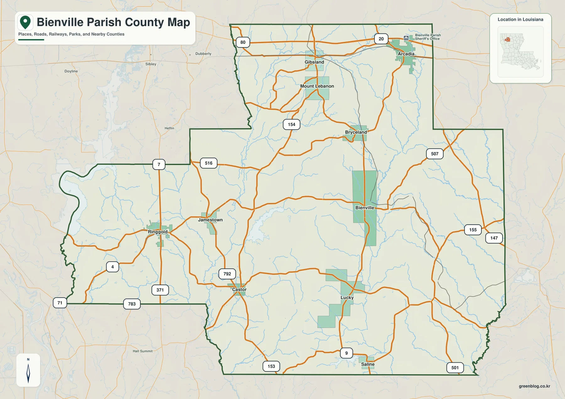
The northern edge is the easiest part of the general map to read. Arcadia and Gibsland sit along I-20 and US 80, and the Bienville Parish Sheriff’s Office is marked in Arcadia. Mount Lebanon lies south of Gibsland, while LA 154 runs deeper into the parish toward Bryceland and the community of Bienville. For a quick orientation, the Arcadia–Gibsland corridor provides the strongest first reference.
Bienville and Bryceland occupy the central interior, where LA 154, LA 507, LA 155, and LA 147 connect several smaller settlements. Farther south, Lucky and Saline become useful references around LA 9, LA 501, and LA 153. Roads are more widely spaced here than around I-20, and many of them curve around stream valleys rather than following a tight grid.
Ringgold is the strongest western reference. LA 4 and LA 371 pass through the area, with LA 7 and LA 516 linking north toward Jamestown and nearby communities. Castor lies southeast of Ringgold near LA 792, LA 783, and LA 153. Arcadia works best for the north, while Ringgold and Castor make the southwestern half easier to understand.
The parish boundary is irregular in several places rather than a simple rectangle. Nearby labels such as Sibley, Doyline, and Heflin provide additional context outside the parish. The map is intended for geographic orientation rather than current traffic, construction, speed limits, or private access conditions.
The six-city view separates the Arcadia–Gibsland north from the Ringgold–Castor south
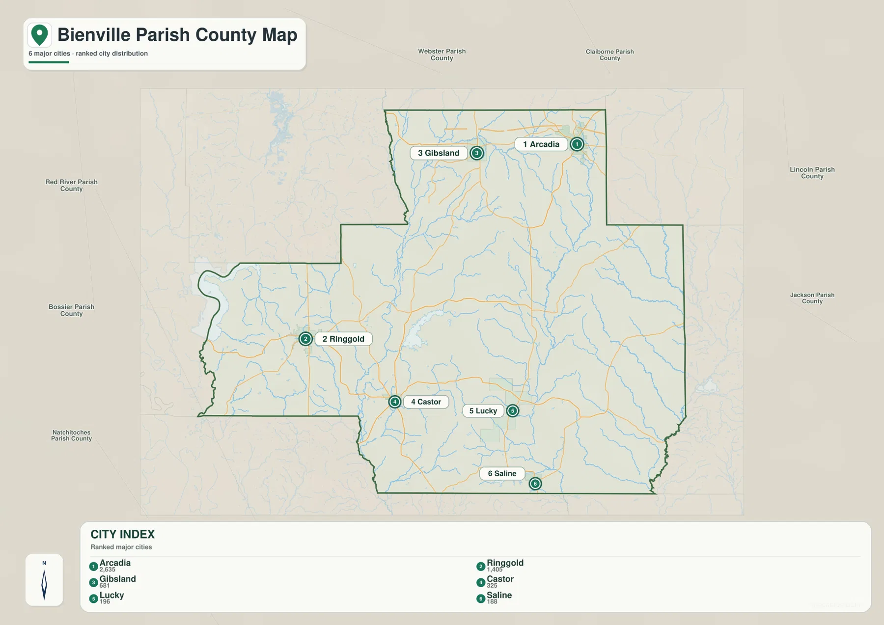
The city-distribution map highlights Arcadia as the largest of the six major city references, followed by Ringgold and Gibsland. Arcadia and Gibsland sit relatively close together in the north, but Ringgold is well to the southwest. Castor, Lucky, and Saline fill the southern half, showing how widely communities are spread across the parish.
Louisiana’s official Bienville Parish profile identifies Arcadia as the parish seat. It lists Arcadia, Gibsland, Mount Lebanon, and Ringgold as towns, while Bienville, Bryceland, Castor, Jamestown, Lucky, and Saline are listed as villages. The Bienville Parish Police Jury is also based in Arcadia, reinforcing the town’s administrative role.
Webster Parish is labeled to the north, Claiborne Parish to the northeast, and Lincoln and Jackson Parishes to the east. Red River and Bossier Parishes lie to the west, with Natchitoches Parish toward the southwest. Those surrounding labels place Bienville Parish in the north-Louisiana interior east of the Shreveport area and southwest of Ruston.
The population figures printed in the city index belong to the source snapshot used to create the map and should not be treated as current official totals. Recent demographic comparisons should use the U.S. Census Bureau. The main value of this file is the relative placement of the six communities.
Saline Bayou and Black Lake Creek form the strongest water references
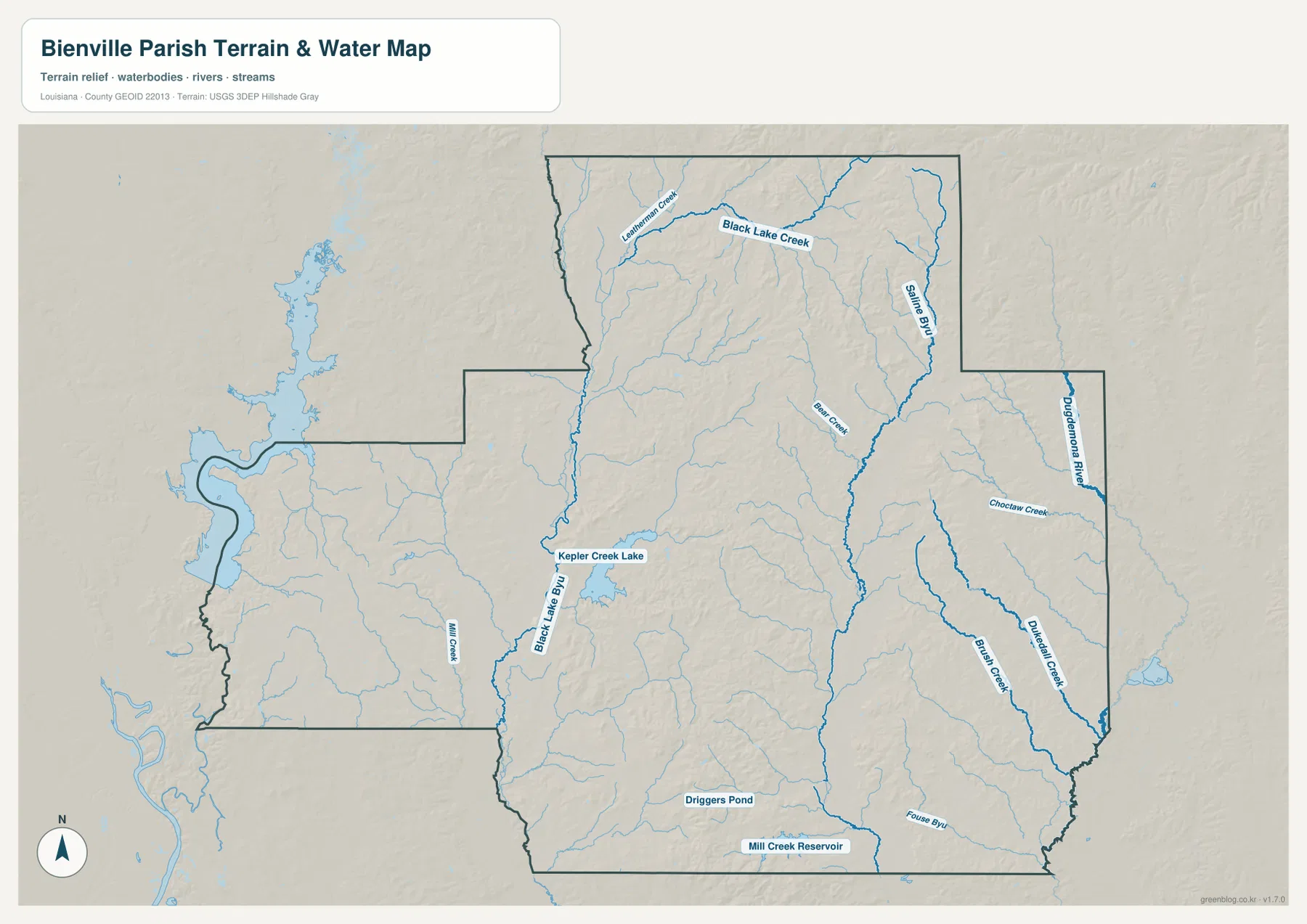
Saline Bayou is one of the strongest water features on the map. It runs through the northeastern and eastern interior and collects numerous small tributaries. Black Lake Creek crosses the northern part of the parish and approaches the same drainage system, while Bear Creek provides another named central-northern reference.
Dugdemona River follows the eastern side, with Choctaw Creek approaching from the west. Brush Creek becomes more prominent farther south. This side of the parish contains fewer large settlement labels, so waterways provide better geographic reference points than towns in several places. Comparing the road and water files also explains why local routes bend around the creek network.
Black Lake Bayou runs through the southwest-central area, with Kepler Creek Lake marked nearby. Mill Creek appears farther west, while Driggers Pond and Mill Creek Reservoir stand out near the southern edge. Bienville Parish’s official site emphasizes the area’s ponds, lakes, wooded land, hunting, and fishing, and the water map shows why those outdoor features are an important part of the local landscape.
This terrain-and-water file is a geographic reference, not a flood-insurance map, depth chart, navigation product, legal shoreline record, or parcel survey. Current flood, boating, access, and property-boundary questions should be checked with FEMA, USGS, or local agencies.
Arcadia, Ringgold, and the eastern waterways reveal three different parish settings
Arcadia is the easiest place to understand as a transportation and administrative center. I-20, US 80, LA 9, and LA 154 all provide strong references nearby, while both Louisiana’s official parish profile and the Bienville Parish Police Jury identify Arcadia as the parish seat. Gibsland’s close position on the same northern corridor strengthens that road-centered character.
The Ringgold–Castor side has a more rural road pattern. LA 4, LA 371, LA 792, and LA 153 matter more than interstate-scale roads, and smaller creeks are spread across the landscape. The western boundary also bends more noticeably, so local roads and stream valleys become more important when moving away from Ringgold.
The eastern side is defined most clearly by water. Saline Bayou, Dugdemona River, Choctaw Creek, and Brush Creek provide the strongest references where towns are fewer. Looking at these three parts together—the northern highway corridor, the southwestern rural road network, and the eastern drainage system—gives a much clearer picture of Bienville Parish than any one layer alone.
Choose the Bienville Parish file by the detail you need
The general map is the best starting point for communities, highways, and the parish outline. The city map is cleaner when the six major settlement references are the main concern. The terrain-and-water map is the strongest choice for Saline Bayou, Black Lake Creek, Dugdemona River, lakes, ponds, and reservoirs.
- General map: Use it for Arcadia, Gibsland, Ringgold, Castor, Bienville, Lucky, Saline, I-20, US 80, LA 9, LA 154, LA 371, LA 4, LA 7, LA 147, LA 155, LA 153, and LA 507.
- City map: Use it to compare Arcadia, Ringgold, Gibsland, Castor, Lucky, and Saline and to see the directions of Webster, Claiborne, Lincoln, Jackson, Red River, and Bossier Parishes.
- Terrain and water map: Use it for Saline Bayou, Black Lake Creek, Bear Creek, Dugdemona River, Choctaw Creek, Brush Creek, Black Lake Bayou, Kepler Creek Lake, and Mill Creek Reservoir.
Each original JPG measures 3638 × 2572 pixels in landscape orientation, preserving more small road and waterway labels than the web previews. Keeping the original aspect ratio is recommended for printing. When using all three files, start with Arcadia and Ringgold, then compare the Saline Bayou and Black Lake Creek side so the same locations remain easy to follow.
Frequently Asked Questions
Which map is best for Arcadia, Ringgold, and I-20?
The general parish map is the best choice because it combines Arcadia, Gibsland, Ringgold, I-20, US 80, LA 9, LA 154, LA 371, and LA 4 in one view.
Where can I see Saline Bayou and Dugdemona River most clearly?
The terrain-and-water map shows Saline Bayou, Black Lake Creek, Bear Creek, Dugdemona River, Choctaw Creek, Brush Creek, Black Lake Bayou, Kepler Creek Lake, and other water features. It is a geographic reference rather than a flood, depth, navigation, or legal-boundary map.
Are the six city rankings current population rankings?
No. The figures beside Arcadia, Ringgold, Gibsland, Castor, Lucky, and Saline belong to the map’s source snapshot. Current population totals and rankings should be checked with the U.S. Census Bureau.
Map File Information
The ZIP contains high-resolution JPG versions of the Bienville Parish general map, city-distribution map, and terrain-and-water map. Use the previews to check Arcadia, Ringgold, Gibsland, the main road network, Saline Bayou, Black Lake Creek, and Dugdemona River before opening the original files.
- Included Files: Use only the versions confirmed in the article and supplied images
- File Type: Use the confirmed download contents
- Intended Use: Printing, education, presentations, and map-based projects
Related Maps
Sources and references
The geographic discussion is based primarily on the supplied Bienville Parish maps, with official parish and Louisiana state pages plus federal boundary and hydrography sources used for context.
- Bienville Parish official website — official parish government and local information.
- Louisiana.gov – Bienville Parish — official parish profile, parish seat, and municipality list.
- U.S. Census Bureau TIGER/Line Shapefiles — official geographic boundary and road data.
- USGS National Hydrography — federal hydrography background for rivers, creeks, lakes, and water features.
Green Map creates custom-edited map images using open geographic data sources such as geoBoundaries, Natural Earth, OpenStreetMap, and government open data. These maps are edited visual materials, not raw data files, and are provided for education, documents, presentations, and graphic reference.