Allen Parish stretches across west-central Louisiana, where US 165 links Oakdale, Oberlin, and Kinder while the Calcasieu River and a dense network of creeks shape the interior. This Allen Parish Map collection shows those communities with US 190, LA 10, LA 26, LA 112, LA 113, Whiskey Chitto Creek, Castor Creek, Bayou Blue, and a cluster of small lakes in the western half. High-resolution map files are available for download in the section below.
The web previews provide a quick way to check roads, town locations, and waterways before downloading the three original high-resolution JPG files in one ZIP. Louisiana’s official Allen Parish profile identifies Oberlin as the parish seat and lists Oakdale, Elizabeth, Kinder, Oberlin, and Reeves among the parish’s municipalities. The maps make the difference between the administrative center, the larger city marker, and the rural road network easy to see.
Table of Contents
US 165 ties Oakdale, Oberlin, and Kinder into one north–south corridor
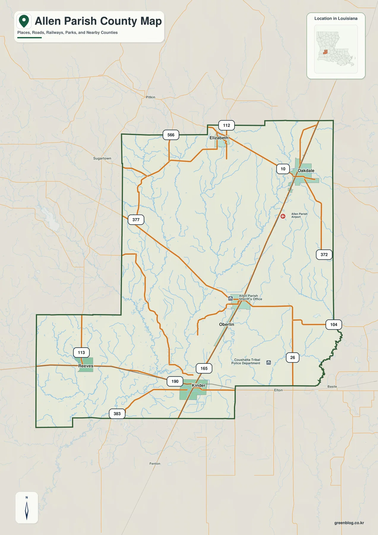
US 165 is the clearest road to find first. It runs from the Kinder area north through Oberlin and continues toward Oakdale, creating a long transportation reference through the eastern half of the parish. US 190 crosses the southern side at Kinder, while LA 26 and LA 104 provide important connections around Oberlin. In Oakdale, LA 10 and LA 372 add strong east–west routes.
Elizabeth sits north of Oberlin and west of Oakdale near LA 112 and LA 566. Reeves is much farther southwest, where LA 113 provides the easiest numbered-road reference. LA 377 cuts diagonally across the western interior toward the Kinder side, and LA 383 appears along the southern extension. The road network therefore has one strong north–south spine but several distinct local branches.
The parish outline itself helps explain the spacing of the communities. A long southwestern extension reaches toward Reeves, while the southeastern boundary steps inward near the Kinder and Elton side. Vernon and Rapides Parishes lie to the north and northwest, Evangeline and Acadia Parishes are to the east, Calcasieu Parish is southeast, and Beauregard and Jefferson Davis Parishes frame the western side.
This map is designed for geographic orientation rather than live navigation. It does not show current traffic, road construction, speed limits, or private access conditions. For driving decisions, use a current road service; for understanding how the communities and state highways fit together, US 165 and US 190 are the best starting points.
Oakdale is the largest city marker, while Oberlin is the parish seat
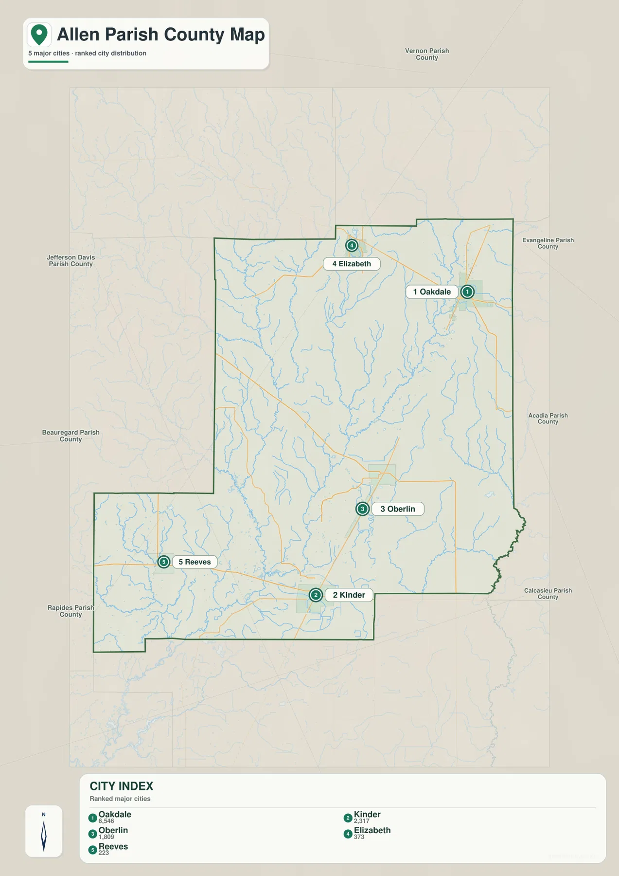
The city-distribution map highlights five places: Oakdale, Kinder, Oberlin, Elizabeth, and Reeves. Oakdale occupies the northeastern side, Kinder sits near the southern edge, and Oberlin lies between them along the US 165 corridor. Elizabeth is farther north, while Reeves is separated from the others in the southwestern extension of the parish.
The map ranks Oakdale first among the five city markers, but Louisiana’s official parish profile identifies Oberlin as the parish seat. That distinction is useful when reading the map: the largest municipal marker and the administrative center are not the same place. Kinder, meanwhile, is especially important for orientation because US 165 and US 190 meet in the southern part of the parish.
The population figures printed in the city index belong to the source snapshot used to make the map and should not be treated as current official counts. Recent demographic work should use the U.S. Census Bureau. The city file is most useful for comparing where the five communities sit relative to one another and to the parish boundary.
Calcasieu River collects creeks from the north, west, and east
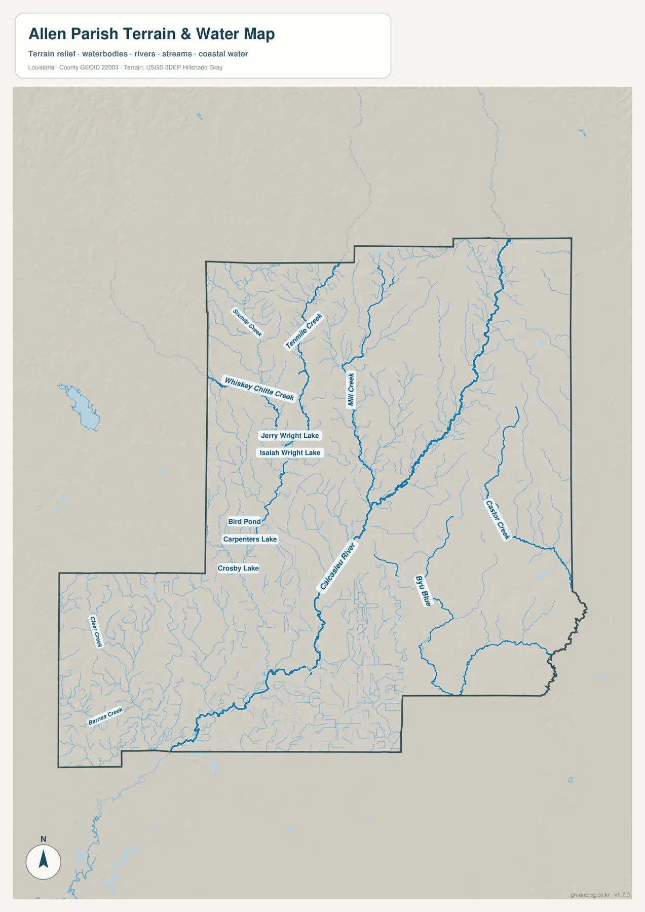
The Calcasieu River is the main water reference on the map. It enters from the north, runs through the central interior, and bends toward the southwest. Sixmile Creek and Tenmile Creek occupy the northwestern side, Whiskey Chitto Creek follows a longer western course, and Mill Creek drains southward toward the Calcasieu River from the north-central area.
The eastern side has a different set of waterways. Castor Creek runs along a long north–south corridor, while Bayou Blue appears farther inside the southeastern half. Barnes Creek and Clear Creek are labeled in the southwestern extension. The result is a parish where numerous creeks and bayous feed a larger river system rather than one broad water body dominating the landscape.
A group of small lakes provides useful landmarks west of the central river corridor. Jerry Wright Lake and Isaiah Wright Lake sit close together, with Bird Pond, Carpenters Lake, and Crosby Lake farther south. Their positions help separate the Whiskey Chitto Creek side from the Calcasieu River corridor when moving between the road and water maps.
The terrain-and-water file is a geographic reference, not a flood map, depth chart, navigation product, parcel survey, or legal shoreline record. Flood risk, boating conditions, water levels, and property-boundary questions require current specialized agency data.
A north-to-south trip shows how each town relates to a different set of waterways
Oakdale combines the US 165 corridor with LA 10 and LA 372 on the northeastern side. Castor Creek lies to the east, while tributaries of the Calcasieu system occupy the interior. North and west toward Elizabeth, LA 112 and LA 566 cross a landscape where Tenmile Creek and Mill Creek become stronger water references.
Oberlin sits near the middle of the US 165 route and serves as the parish seat. The Calcasieu River runs west of the town, while Bayou Blue lies farther southeast. The general map also labels the Allen Parish Sheriff’s Office and the Coushatta Tribal Police Department in this central-southern area, giving additional landmarks for readers trying to match the road and water files.
Kinder marks the southern junction where US 190 crosses US 165. West toward Reeves, LA 113 leads into the parish’s long southwestern extension, while Whiskey Chitto Creek and the cluster of small lakes become more prominent. This change from Oakdale in the northeast to Kinder and Reeves in the south and southwest is one of the clearest ways to understand Allen Parish as a whole.
Choose the Allen Parish file by the detail you need
The general map is the strongest starting point for numbered roads, communities, and the parish outline. The city map is cleaner when the five major settlement references are all that matter. The terrain-and-water map is the best file for the Calcasieu River, Whiskey Chitto Creek, Castor Creek, Bayou Blue, and the small lake group west of the river.
- General map: Use it for Oakdale, Oberlin, Kinder, Elizabeth, Reeves, US 165, US 190, LA 10, LA 26, LA 104, LA 112, LA 113, LA 372, LA 377, LA 383, and LA 566.
- City map: Use it to compare the positions of the five major city markers and their relationship to neighboring Louisiana parishes.
- Terrain and water map: Use it for Calcasieu River, Whiskey Chitto Creek, Sixmile Creek, Tenmile Creek, Mill Creek, Castor Creek, Bayou Blue, and the labeled lakes and ponds.
Each original JPG measures 2572 × 3638 pixels in portrait orientation, preserving more small road and stream labels than the web previews. Keeping the original aspect ratio is recommended for printing.
Frequently Asked Questions
Which map is best for Oakdale, Oberlin, Kinder, and US 165?
The general map is the best choice because it shows the full US 165 corridor together with US 190 at Kinder, LA 10 at Oakdale, LA 26 and LA 104 near Oberlin, and the parish boundary.
Is Oakdale the parish seat because it is the largest city marker?
No. The city map ranks Oakdale first among the five major city markers, but Louisiana’s official Allen Parish profile identifies Oberlin as the parish seat. The map and the administrative designation describe different aspects of the parish.
Where can I see Calcasieu River and Whiskey Chitto Creek together?
The terrain-and-water map shows both waterways along with Sixmile Creek, Tenmile Creek, Mill Creek, Castor Creek, Bayou Blue, and the labeled lakes and ponds. It is a geographic reference rather than a flood, depth, navigation, or legal-boundary map.
Map File Information
The ZIP contains high-resolution JPG versions of the Allen Parish general map, city map, and terrain-and-water map. Use the previews to check Oakdale, Oberlin, Kinder, US 165 and 190, the Calcasieu River, and major tributaries before opening the original files.
- Included Files: Use only the versions confirmed in the article and supplied images
- File Type: Use the confirmed download contents
- Intended Use: Printing, education, presentations, and map-based projects
Related Maps
Sources and references
The geographic discussion is based primarily on the supplied Allen Parish maps, with Louisiana state, municipal, Census, and USGS sources used for context.
- Louisiana.gov – Allen Parish Profile — official parish-seat and municipality information.
- City of Oakdale official website — official city information and services.
- U.S. Census Bureau TIGER/Line Shapefiles — official geographic boundary and road data.
- USGS National Hydrography — federal hydrography background for rivers, creeks, bayous, and lakes.
Green Map creates custom-edited map images using open geographic data sources such as geoBoundaries, Natural Earth, OpenStreetMap, and government open data. These maps are edited visual materials, not raw data files, and are provided for education, documents, presentations, and graphic reference.