Taylor County sits in central Kentucky with Campbellsville serving as its clear settlement and road focus. On this Taylor County Kentucky Map page, the supplied files show Campbellsville, KY 55 and KY 210, the branching Pitman Creek system, Green River, and rolling terrain ranging from about 173 to 363 meters. The web images are convenient for a quick look, and the original high-resolution JPG versions of all four maps can also be downloaded together as a ZIP archive. High-resolution map files are available for download in the section below.
The county is not shaped like a simple rectangle. A broad northern half extends around a web of small valleys, the eastern side reaches into more strongly dissected hills, and a narrow southern point drops toward the Green River corridor. Campbellsville lies slightly southwest of the visual center, where several numbered roads converge. Looking at the road, water, and elevation files together helps explain why the city works as an orientation point while the countryside beyond it becomes increasingly curvy and valley-driven.
Table of Contents
Campbellsville anchors the road network inside the county outline
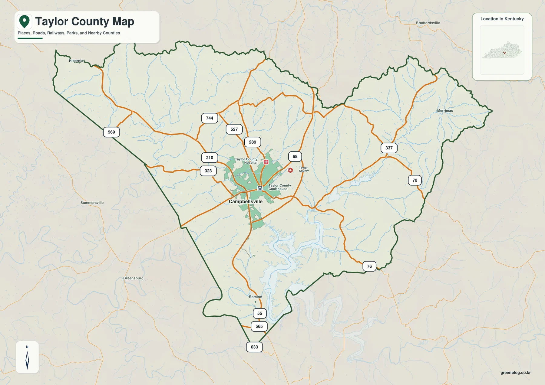
Campbellsville is the first place to find on the general county map. The built-up area is marked near the center-southwest, with Taylor County Courthouse and the hospital shown nearby. KY 55 leaves the city toward the narrow southern end of the county, while KY 210 and KY 323 approach from the west. To the north and northeast, KY 289, KY 527, and KY 744 branch through the countryside. East of Campbellsville, KY 68, KY 70, and KY 337 head toward a different set of ridges and stream valleys.
The road pattern becomes less centralized as soon as the map moves away from Campbellsville. KY 569 curves through the northwestern side, KY 337 crosses the eastern half, and KY 76 reaches toward the southeastern boundary. In the south, KY 565 and KY 633 connect with the KY 55 corridor near the county’s pointed lower section. Many smaller roads bend repeatedly rather than forming a square grid, a pattern that makes more sense after comparing the road map with the shaded elevation surface.
Labels beyond the boundary provide useful bearings. Bradfordsville appears north of Taylor County, Merrimac is outside the eastern side, Summersville lies to the west, and Greensburg is southwest. The simplified city map adds the neighboring county names: Marion County to the north, Casey County to the east, and Green, Adair, and Larue counties toward the west and southwest. These labels make it easier to understand where the numbered routes are heading without treating the map as a turn-by-turn navigation product.
The official Taylor County website identifies Campbellsville as the county seat, which matches the visual emphasis of the map. Still, the general map should be used as a geographic reference rather than a source for live traffic, closures, or road construction. For orientation, a useful method is to locate Campbellsville first, trace KY 55 south and KY 210 west, and then follow the eastern routes toward KY 70, KY 337, and KY 76. That sequence gives the many secondary roads a clearer context.
A one-city index makes Campbellsville easy to place
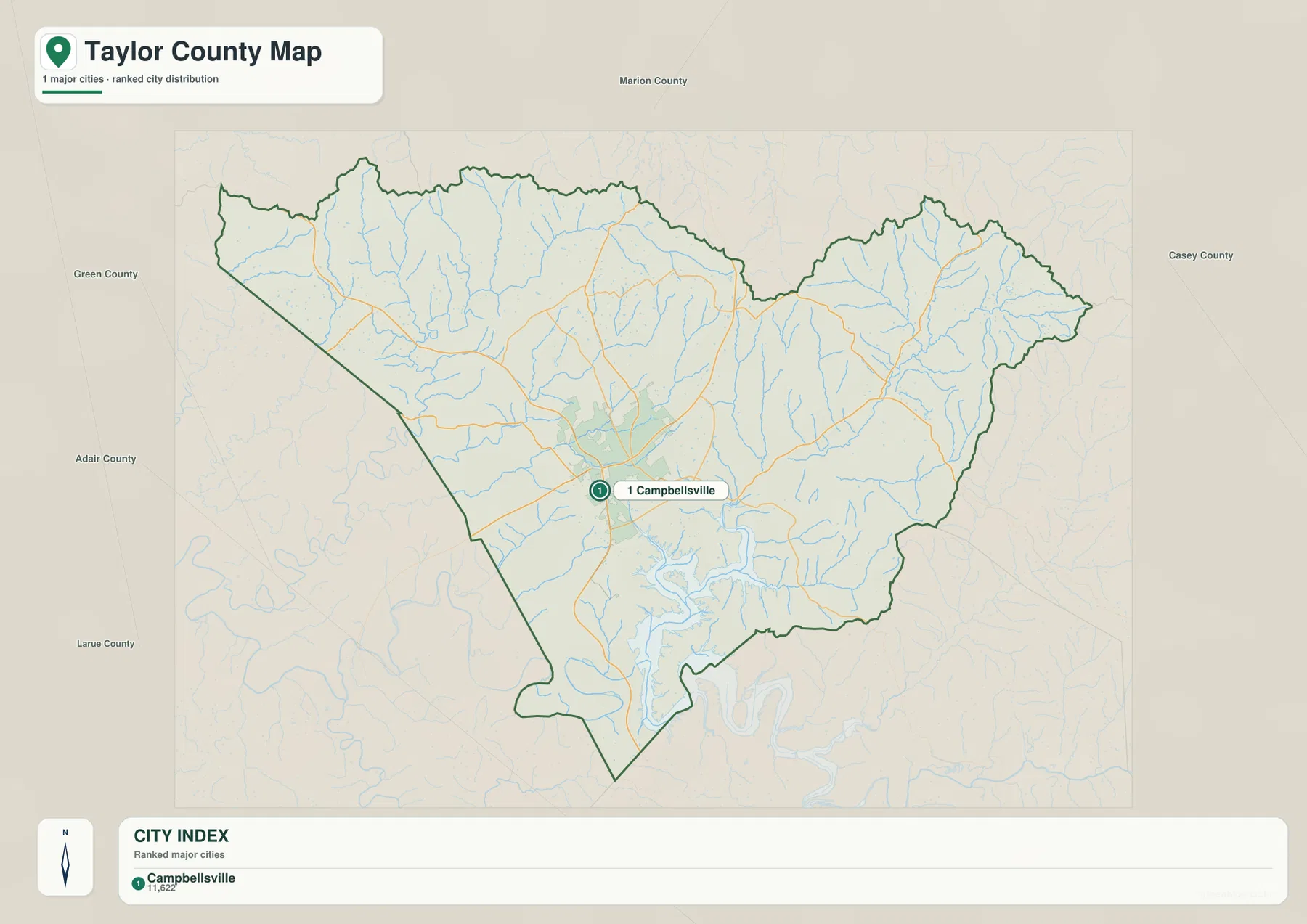
The city map strips away much of the road labeling and gives Campbellsville almost all of the visual attention. It is the only major city listed in the index and appears slightly southwest of the county’s geometric middle. This simplified presentation is useful when a reader only needs to answer two questions: where is Campbellsville inside Taylor County, and which neighboring counties lie around it? The official county and city websites reinforce Campbellsville’s role as the administrative and community center.
North of the boundary is Marion County, while Casey County runs along the eastern side. Green County is shown to the northwest, Adair County to the west and southwest, and Larue County along the southwestern direction. The county outline narrows noticeably toward the south, so Campbellsville is not centered inside a regular box. That irregular shape matters when explaining why some roads reach a boundary quickly while others travel through a much larger stretch of Taylor County countryside.
The number shown with Campbellsville in the city index belongs to the map’s source context and should not be treated here as a current official population estimate. Population counts can change with census releases and annual estimates. For demographic work, use current U.S. Census Bureau data or an up-to-date local source. The purpose of this file is much simpler: it provides a clean visual for city location and the surrounding county directions without the clutter of every route and creek.
That simplicity also makes the city map a good opening image for a classroom slide or county profile. After establishing Campbellsville, the general map can add the KY 55, KY 210, and KY 70 road framework. The terrain-and-water map then introduces the Pitman Creek branches and Green River, while the elevation map explains why the eastern and northern countryside is more strongly ridged. Each file answers a different geographic question rather than acting as a duplicate of the others.
Pitman Creek branches spread west of the eastern ridge country
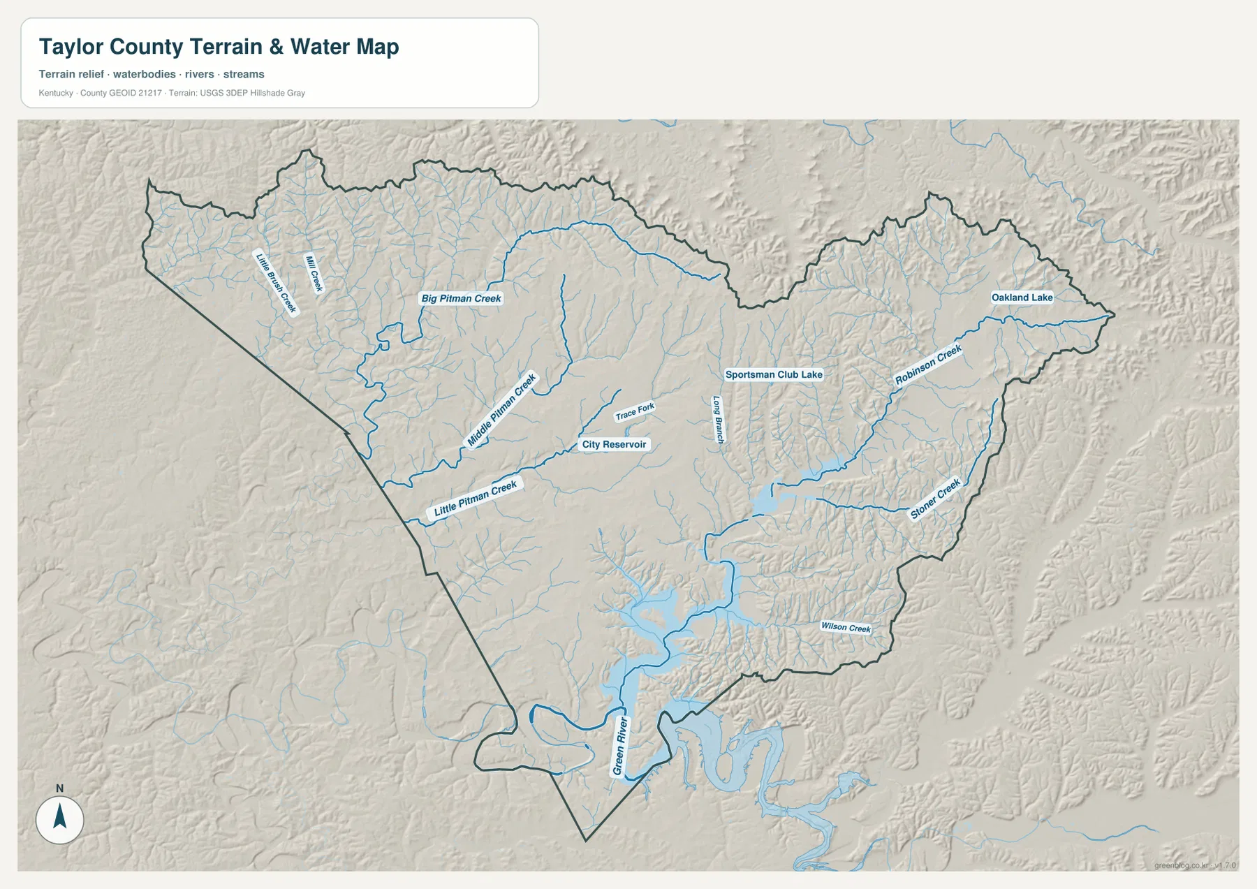
The western and central parts of the water map are organized around the Pitman Creek system. Big Pitman Creek follows a long course through the northwest, while Middle Pitman Creek and Little Pitman Creek occupy separate valleys closer to the center and southwest. Trace Fork and the City Reservoir appear near the Campbellsville area. With road shields removed and terrain shading added, these streams become much easier to follow than they are on the general county map.
Moving east, Long Branch runs through the central-eastern area and Sportsman Club Lake is labeled nearby. Robinson Creek occupies a long northeastern valley, with Oakland Lake close to the eastern edge. Farther south, Stoner Creek and Wilson Creek cut through the hillier southeastern side. The tributaries are not arranged as a simple parallel set of lines; they turn and branch between narrow ridges, producing the deeply textured landscape visible in the shaded background.
Green River is the dominant named watercourse at the southern end. The channel and connected low ground occupy the pointed lower part of the county, where several smaller drainages converge in the same general direction. Campbellsville’s official city website highlights Green River Lake among regional partners and destinations, and Kentucky State Parks maintains Green River Lake State Park in Campbellsville. Those regional references help place the southern water system in context, although this map itself is intended to show waterways and terrain rather than recreation facilities.
The water file should not be used as a flood-hazard, depth, navigation, property, or legal shoreline map. Its blue lines and water bodies are best for understanding relative positions: where Big, Middle, and Little Pitman creeks run, how Robinson and Stoner creeks occupy eastern valleys, and where Green River sits at the southern end. For detailed hydrography, flood studies, or water-management decisions, consult current agency data such as the USGS National Hydrography resources and the appropriate local or federal products.
The 173–363 meter surface separates low stream valleys from higher ridges
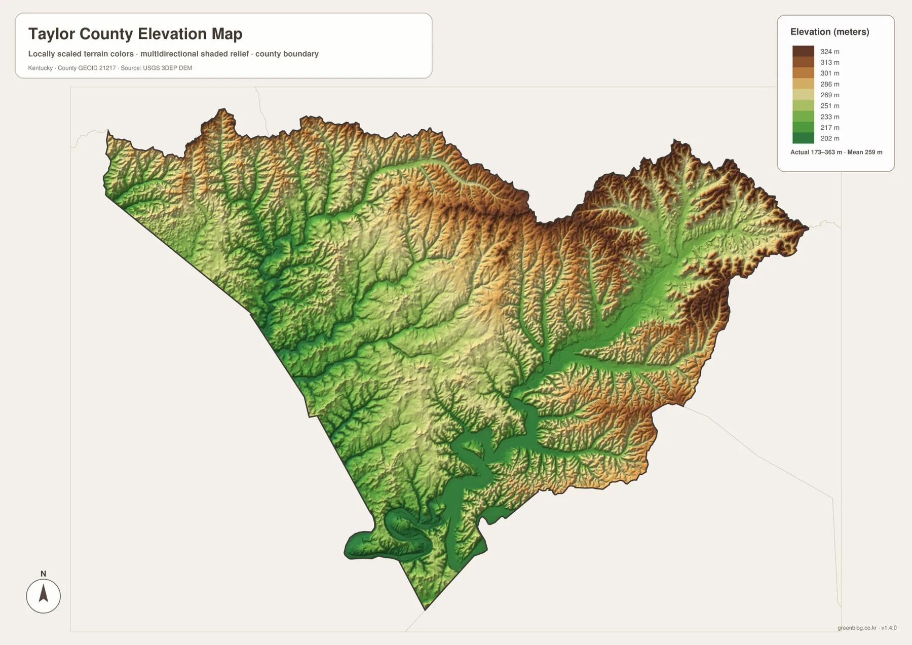
The legend on the elevation map reports an actual county range of about 173 to 363 meters, with a mean near 259 meters. Green tones represent lower ground, while yellow and brown indicate progressively higher terrain. The broadest low areas occur along major stream corridors and the southern Green River system. By contrast, the northern rim and much of the eastern side contain long brown ridges separated by narrow green valleys.
The northwestern landscape is especially useful for comparing water and relief. Big Pitman Creek and its tributaries create branching low corridors, while higher ground remains between them. The same relationship continues east of Campbellsville, where Robinson Creek and Stoner Creek occupy lower routes through a more strongly dissected hill pattern. Roads that look unusually curvy on the general map often follow or cross these valleys rather than cutting directly across every ridge.
Campbellsville and the surrounding central area show a broader zone of moderate relief than the higher northern and eastern margins. South of the city, lower terrain leads toward Green River, and the narrow southern extension contains a pronounced green corridor. This does not mean the entire central county is flat. Small ridges and short tributary valleys remain visible, but the transition between them is less dramatic than in the deeply cut eastern side.
This elevation image is a generalized county-scale surface. The approximately 173–363 meter range and mean near 259 meters are useful for explaining regional relief, but they are not survey elevations for an individual property, bridge, drainage structure, or construction site. Engineering and design work should rely on higher-resolution source data such as USGS 3DEP products and, when required, professional field surveying.
Reading west-to-east differences from Campbellsville
Taylor County becomes easier to understand when Campbellsville is used as a reference point and the surrounding landscapes are compared. To the west and northwest, the Pitman Creek branches create a broad network of valleys mixed with rural roads. The central area contains Campbellsville, the City Reservoir, and several route junctions. East of the city, Robinson Creek, Stoner Creek, and their tributaries cut into a denser ridge pattern. Southward, Green River and the lower valley floor create a different landscape again.
The road and water maps show why no single straight corridor defines the entire county. KY 210 and KY 323 approach Campbellsville through the western side, where Little Pitman Creek and smaller tributaries are nearby. North of the city, KY 289, KY 527, and connecting roads cross repeated small valleys. The eastern routes toward KY 337, KY 70, and KY 76 encounter more rugged relief around the Robinson and Stoner creek systems. The relationship is not one-to-one, but the terrain helps explain the frequency of bends and route changes.
For a county presentation, one effective sequence is to begin with the city map and establish Campbellsville relative to Marion, Casey, Green, Adair, and Larue counties. The general map can then add the major roads. Next, the terrain-and-water map can trace Big Pitman Creek through the western side and Green River at the southern end. Finishing with the elevation map shows the same stream corridors as lower green bands between higher ridges, connecting the human and physical geography without requiring technical GIS analysis.
Match the Taylor County file to the question you need to answer
The general county map is the best choice when Campbellsville, numbered highways, local place labels, and the county boundary need to appear together. The city map is intentionally sparse and works better for a clean orientation to Campbellsville and the neighboring counties. Natural geography is clearer in the terrain-and-water file, while the elevation image is the strongest option for comparing low valleys with higher ridges across the 173–363 meter range.
- County map: useful for Campbellsville, KY 55, KY 210, KY 70, KY 68, KY 337, KY 76, smaller roads, local labels, and the county outline.
- City map: useful for a simplified view of Campbellsville and the directions toward Marion, Casey, Green, Adair, and Larue counties.
- Terrain and water map: useful for Big, Middle, and Little Pitman creeks, Robinson Creek, Stoner Creek, Wilson Creek, Green River, and labeled lakes or reservoirs.
- Elevation map: useful for comparing the roughly 173–363 meter relief, lower stream corridors, and the higher northern and eastern ridges.
A simple classroom exercise is to locate Campbellsville first, trace KY 55 south and KY 210 west, and then switch to the water file to find the Pitman Creek branches. Students can move to the elevation map and look for those same drainage corridors as lower green areas. The southern Green River corridor provides another clear comparison. This approach connects roads, water, and relief around real Taylor County features instead of treating each map as a separate list of symbols.
Each original JPG measures 3638 by 2572 pixels, giving more room to inspect road shields, creek labels, and shaded relief than the web previews. Keep the original aspect ratio when printing, and avoid reducing the image so far that small water labels become unreadable. Because the four files emphasize different subjects, selecting the map that matches the task generally produces a clearer result than trying to combine every theme into one crowded image.
Frequently Asked Questions
Which file shows Campbellsville, KY 55, and KY 210 together?
Use the general county map. It places Campbellsville and the Taylor County boundary in the same frame with KY 55, KY 210, KY 70, KY 68, KY 289, KY 337, KY 76, and several other numbered roads. If you only need Campbellsville’s position relative to neighboring counties, the simplified city map is easier to read.
Where are the Pitman Creek branches and Green River easiest to see?
The terrain-and-water map is the appropriate file. It labels Big Pitman Creek, Middle Pitman Creek, Little Pitman Creek, Green River, Robinson Creek, Stoner Creek, Wilson Creek, City Reservoir, Oakland Lake, and other water features. It is a geographic reference rather than a flood-risk, water-depth, navigation, or legal-boundary product.
Can the 173–363 meter elevation map be used for surveying or construction?
No. The elevation image summarizes broad relief across Taylor County and is useful for comparing low stream valleys with higher northern and eastern ridges. The approximately 173–363 meter range and mean near 259 meters are not parcel-level survey measurements. Engineering, drainage, design, and construction decisions require more precise source data and professional measurements when appropriate.
Map File Information
The ZIP contains high-resolution JPG versions of the Taylor County general map, city map, terrain-and-water map, and elevation map. Use the previews to review Campbellsville, the road network, the Pitman Creek system, Green River, and the roughly 173–363 meter relief before selecting the files for your project.
- Included Files: Use only the versions confirmed in the article and supplied images
- File Type: Use the confirmed download contents
- Intended Use: Printing, education, presentations, and map-based projects
Related Maps
Sources and references
The road, settlement, water, and elevation descriptions are based primarily on the supplied Taylor County map assets. The following official sources provide local context and background for county, hydrography, and elevation data.
- Taylor County, Kentucky official website — local government information identifying Campbellsville as the county seat.
- City of Campbellsville official website — municipal and community information for Campbellsville and Taylor County.
- U.S. Census Bureau TIGER/Line Shapefiles — official geographic resources for county boundaries, roads, and related features.
- USGS National Hydrography — official hydrographic data background for rivers, creeks, lakes, and drainage features.
- USGS 3D Elevation Program — official U.S. elevation and terrain data program.
Green Map creates custom-edited map images using open geographic data sources such as geoBoundaries, Natural Earth, OpenStreetMap, and government open data. These maps are edited visual materials, not raw data files, and are provided for education, documents, presentations, and graphic reference.