Spencer County occupies a compact part of north-central Kentucky where Taylorsville serves as the main settlement and road reference, while Salt River and Taylorsville Lake dominate the eastern half of the landscape. This Spencer County Kentucky map set shows the county boundary, Taylorsville, KY 55, KY 44, KY 248, the branching creek network, and relief ranging from about 131 to 266 meters. You can review all four maps on the page and download the original high-resolution JPG files together in one ZIP.
The county is small enough that Taylorsville is never far from the center of the discussion, but the maps reveal a strong west-to-east contrast. Roads and small drainage lines spread through the western rural area, KY 55 and KY 44 converge around Taylorsville, and the eastern side becomes increasingly shaped by Salt River, tributary valleys, and the irregular arms of Taylorsville Lake. Shelby County lies to the north and Anderson County to the east, while Jefferson, Bullitt, and Nelson counties frame the western and southwestern sides. Looking at these relationships together gives a much clearer picture than a simple county outline.
Table of Contents
Taylorsville is the road anchor for KY 55 and KY 44
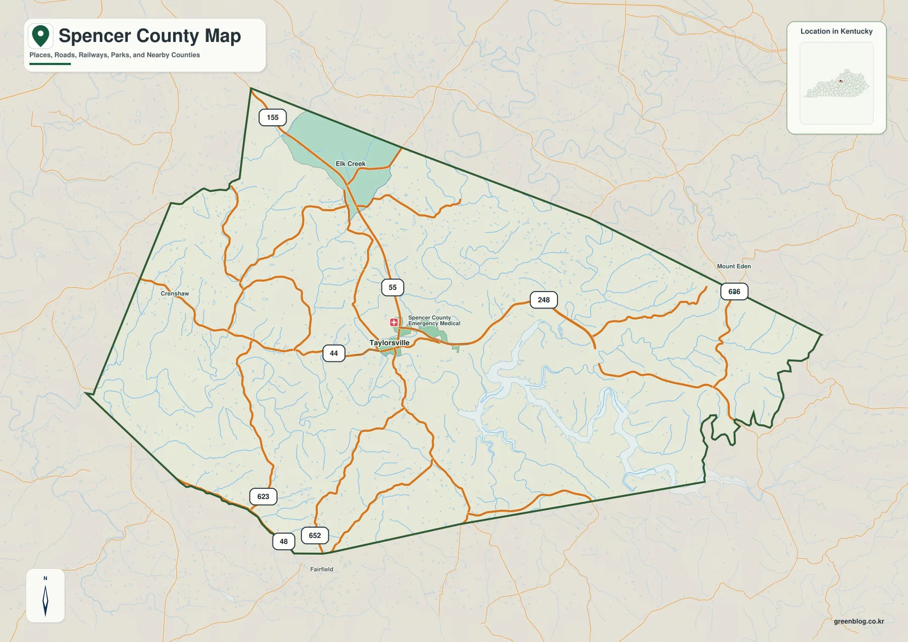
The general map makes Taylorsville the easiest place to orient yourself. KY 55 runs north-south through the community, while KY 44 approaches from the west and continues through the central area. KY 248 leaves the Taylorsville area toward the east, leading into the more dissected lake-and-creek country. These three routes create a recognizable framework that can be used to place most of the other roads and water features in the county.
Additional numbered routes fill in the outer portions of the map. KY 155 enters the northwestern area, KY 623, KY 48, and KY 652 appear near the southern and southwestern edge, and KY 636 serves the eastern side near the Mount Eden direction. Between these labeled highways is a finer network of local roads, many of which curve around stream valleys rather than crossing the terrain in straight lines. Spencer County therefore looks less like a county divided by one major expressway and more like a rural road web radiating from Taylorsville.
Smaller place labels help with orientation without competing with Taylorsville. Elk Creek appears north of the county seat, Crenshaw is labeled in the western side, Mount Eden sits just beyond the eastern boundary, and Fairfield appears south of the county. They are useful directional references when reading the road map, especially because the county outline has several angled and irregular sections. The eastern road network also becomes more winding as it approaches the valleys associated with Taylorsville Lake.
Transportation context matters beyond the county boundary as well. The Kentucky Transportation Cabinet maintains a dedicated project page for the KY 55 and KY 155 corridor between Spencer and Jefferson counties, reflecting the importance of the northwestern connection toward the Louisville area. This map, however, is not a live traffic or construction product. Road closures, lane changes, and current travel conditions should always be checked through current transportation sources before a trip.
A one-city map makes Taylorsville’s position especially clear
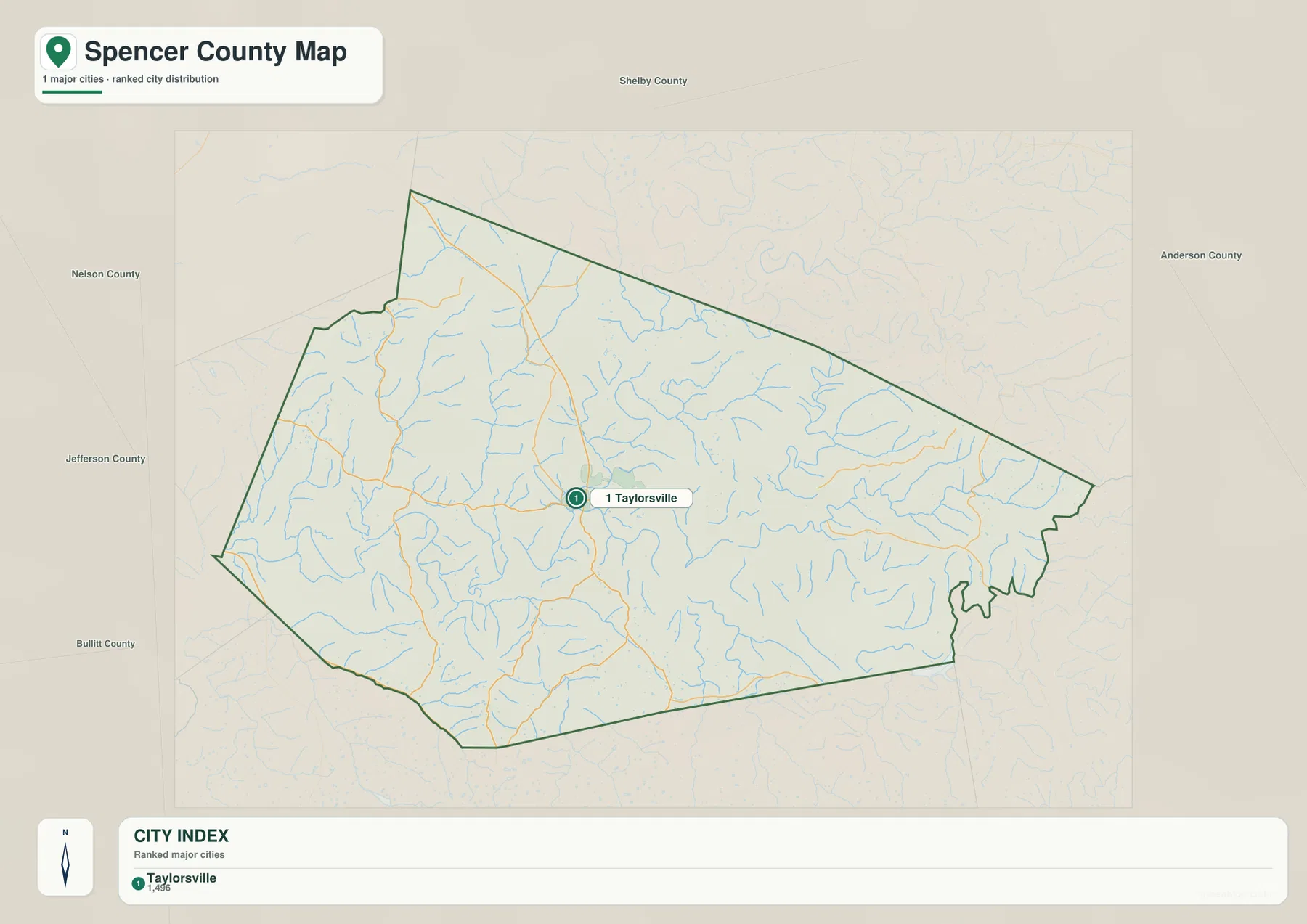
The city map contains a single ranked major city: Taylorsville. That simplicity is useful rather than limiting. With most minor roads and place labels removed, the map shows that Taylorsville sits slightly west of the geographic center and serves as the primary reference point for the county. Kentucky’s official local profile identifies Taylorsville as the county seat of Spencer County, which matches the strong central role it has on the supplied maps.
Neighboring counties are easier to understand on this simplified version. Shelby County occupies the north, Anderson County is to the east, and the western to southwestern perimeter touches the directions of Jefferson, Bullitt, and Nelson counties. The outline is not a neat rectangle: the northwestern side steps inward and outward, the northern edge angles southeast, and the eastern end has several irregular notches. Those boundary shapes make the city map useful for regional orientation before adding the more detailed road layer.
The city index includes a numeric value next to Taylorsville, but it should not be treated here as a current official population estimate. Map-production values can reflect a different year or selection method from the latest Census release. If population or demographic statistics are needed, use a current Census product or county source. This map is best understood as a settlement-location graphic: it tells you where the principal city is, not what the latest population count should be.
A sparse city map also makes a useful companion to the denser county map. In a classroom, report, or local guide, the city map can establish Taylorsville and the neighboring counties first. The general map can then add KY 55, KY 44, KY 248, and the local road network without forcing the audience to process every label at once. The water and elevation maps complete the picture by showing what lies between those roads.
Salt River opens into the branching arms of Taylorsville Lake
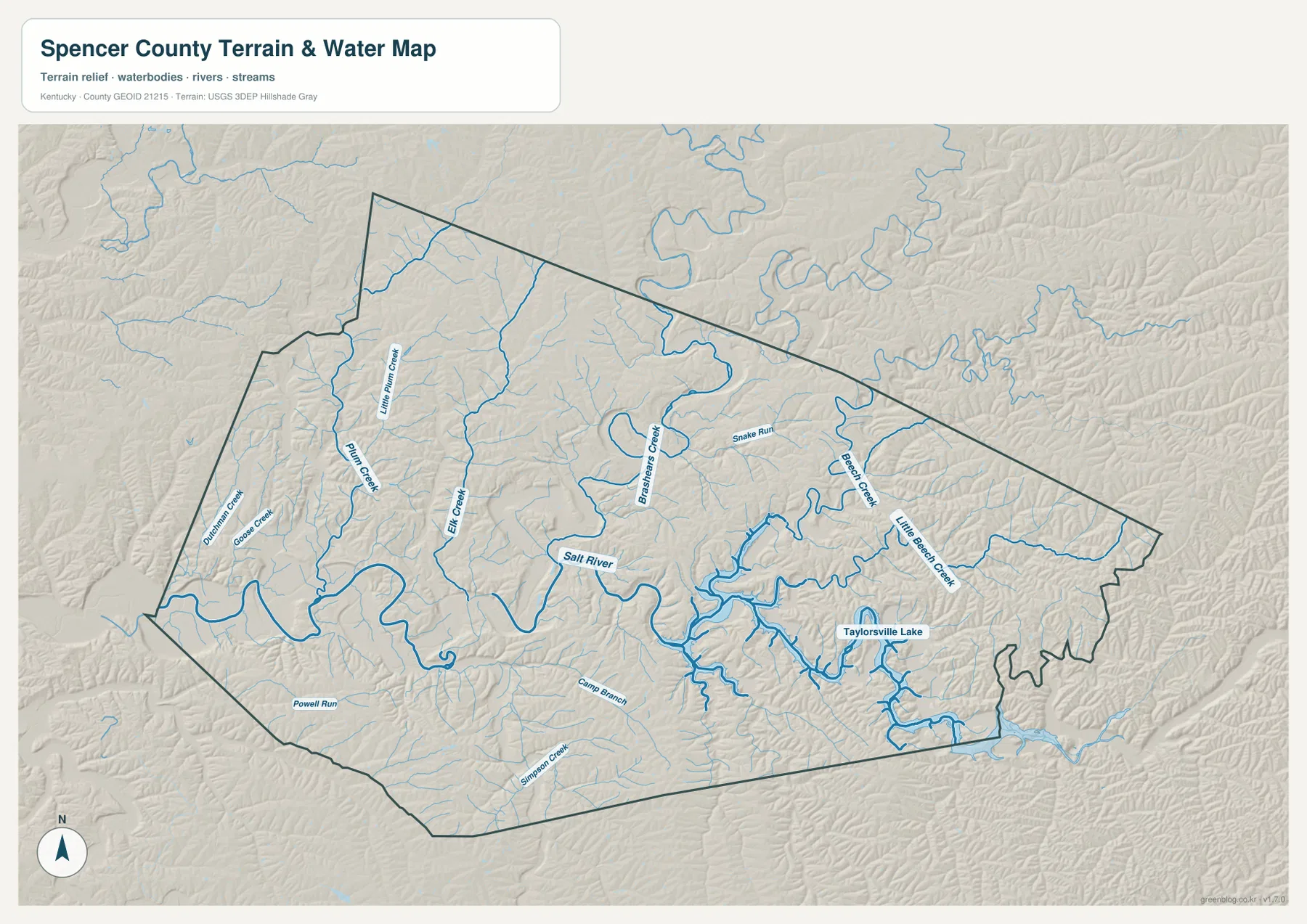
The water map provides the strongest visual explanation for the shape of eastern Spencer County. Salt River enters from the west, bends repeatedly across the lower central part of the county, and then broadens into the irregular water body of Taylorsville Lake. The lake follows preexisting valleys, so its shoreline forms long narrow arms rather than a simple circular basin. This branching geometry is one of the most distinctive features in the entire four-map set.
Several named creeks feed the larger system. Plum Creek and Little Plum Creek occupy the west and northwest, Elk Creek descends through the north-central area, and Brashears Creek is prominent east of the center. Beech Creek and Little Beech Creek drain the eastern side toward the lake. Dutchman Creek and Goose Creek appear farther west, while Snake Run, Cane Branch, Simpson Creek, and Powell Run add smaller valleys to the network. Together they show that nearly every part of the county is cut by short drainage lines.
These waterways explain many of the curves seen on the road map. In western Spencer County, roads thread between the Salt River valley and the smaller Plum Creek system. East of Taylorsville, KY 248 continues toward the lake country but encounters a landscape broken into narrow ridges and tributary valleys. Local roads must cross, follow, or avoid those low areas, which produces a more irregular pattern than the relatively direct central portions of KY 55 and KY 44.
The map should be used for geographic context rather than flood, navigation, water-quality, or property decisions. A blue creek line or lake outline does not establish flood-zone status, channel ownership, exact shoreline position, water depth, or safe boating conditions. Those questions require current specialized information from agencies such as USGS and relevant state or local authorities. Here, the value of the water map is seeing how Salt River, the lake, and the named creeks fit together across one county.
A 131–266 meter relief range separates valley floors from rounded uplands
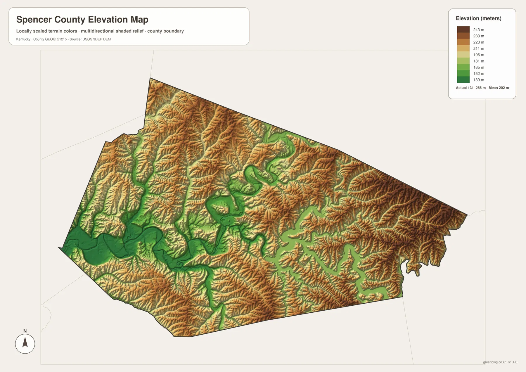
The elevation legend reports an actual county range of roughly 131 to 266 meters, with a mean near 202 meters. Greens mark the lower surfaces, while yellow, tan, and brown indicate progressively higher ground. The broadest low corridor follows Salt River from west to east. On both sides of that corridor, short ridges rise quickly enough to create a strongly textured shaded-relief surface even though Spencer County is not mountainous.
Western Spencer County contains a wide green valley around Salt River, but numerous narrow ridges interrupt the surrounding terrain. The north and northwest are especially dissected, with many small valleys separating rounded uplands. Around Taylorsville, lower ground associated with the river system is mixed with modest hills rather than forming one completely flat basin. This helps explain why local roads can become curvy soon after leaving the central town area.
The eastern half shows the relationship between elevation and the lake even more clearly. Green lowlands branch into long fingers around Taylorsville Lake, while the land between those arms rises into brown ridges. The valleys associated with Brashears Creek, Beech Creek, Little Beech Creek, and smaller tributaries reappear as lower channels on the elevation map. Comparing the two maps side by side makes the connection between drainage and relief obvious without requiring detailed contour lines.
This is a generalized county-scale elevation surface, not a survey product. The 131–266 meter range and the mean near 202 meters are appropriate for describing regional relief, but they are not precise elevations for a house lot, bridge, drainage structure, or construction site. Engineering, legal, and design work should use higher-resolution source data such as USGS 3DEP products and, where required, professional field measurements.
The western road country and eastern lake country feel different on the same map
One useful way to understand Spencer County is to compare its western and eastern halves rather than treating the entire county as one uniform landscape. West of Taylorsville, the map is dominated by a web of rural roads, Salt River bends, and smaller tributaries. East of town, the lake and its tributary valleys occupy much more visual space. Roads become more winding and the elevation map shows narrow ridges standing between branching lowlands.
The county’s external relationships reinforce that contrast. Shelby County stretches along the north, Anderson County borders the eastern side near the lake-and-ridge terrain, and Jefferson, Bullitt, and Nelson counties lie toward the west and southwest. Taylorsville is therefore positioned between the more urbanized Louisville direction and the rolling interior counties to the east and south. KY 55 is a useful north-south reference, while KY 44 provides a clear west-to-central connection through the county seat.
For a presentation, the four files can be used as a sequence rather than as competing versions. Start with the city map to place Taylorsville and the neighboring counties, add the general map for KY 55, KY 44, and KY 248, then use the water map to follow Salt River into Taylorsville Lake. Finish with the elevation map to show why the river corridor is low and the land between tributaries rises into rolling ridges. That progression explains both human and physical geography with relatively little clutter.
Choose the Spencer County file that matches the question
The general county map is the most complete choice when you need Taylorsville, KY 55, KY 44, KY 248, other numbered routes, local place labels, and the county outline in one image. The city map is intentionally simpler and works well when the main question is where Taylorsville sits relative to Shelby, Anderson, Jefferson, Bullitt, and Nelson counties. For natural geography, the terrain-and-water map provides the clearest view of Salt River and the tributary system, while the elevation map emphasizes the low valleys and higher uplands.
- County map: best for Taylorsville, KY 55, KY 44, KY 248, KY 155, KY 636, local roads, place labels, and the county boundary.
- City map: best for a clean view of Taylorsville and the directions toward Shelby, Anderson, Jefferson, Bullitt, and Nelson counties.
- Terrain and water map: best for Salt River, Taylorsville Lake, Plum Creek, Elk Creek, Brashears Creek, Beech Creek, and other tributaries.
- Elevation map: best for comparing the approximately 131–266 meter range, the low river corridor, and the surrounding rolling ridges.
For classroom use, a simple exercise is to locate Taylorsville first, trace KY 55 and KY 44 through the center, then switch to the water map and follow Salt River eastward until it expands into Taylorsville Lake. The elevation map can then be used to identify the same corridor as a broad green lowland. This sequence makes it easy to connect transportation, drainage, and topography without turning the activity into a technical GIS lesson.
The original JPG files are 3638 by 2572 pixels each, so road shields, creek labels, and shaded relief are easier to inspect than in the web previews. Preserve the aspect ratio when printing and avoid excessive reduction if small labels are important. Because the four maps emphasize different information, selecting the file that matches the task usually produces a cleaner result than trying to combine every theme into a single image.
Frequently Asked Questions
Which map is best for seeing Taylorsville, KY 55, and KY 44 together?
Use the general county map. It places Taylorsville and the KY 55–KY 44 junction in the same frame and also shows KY 248 to the east, KY 155 in the northwest, and KY 636 on the eastern side. If you only need Taylorsville’s position relative to the surrounding counties, the simplified city map is cleaner.
Where can I see Salt River and Taylorsville Lake most clearly?
The terrain-and-water map is the appropriate file. It shows Salt River crossing the county and expanding into Taylorsville Lake, together with Plum Creek, Elk Creek, Brashears Creek, Beech Creek, Little Beech Creek, and several smaller tributaries. It is intended for geographic reference rather than flood-risk, depth, navigation, or legal shoreline decisions.
Can the 131–266 meter elevation map be used for property surveying?
No. The elevation map summarizes broad terrain differences across Spencer County. The approximately 131–266 meter range and mean near 202 meters are useful for comparing the low Salt River and lake valleys with surrounding uplands, but surveying, engineering, drainage design, and construction require more precise source data and professional measurements.
Map File Information
The ZIP contains high-resolution JPG versions of the Spencer County general map, city map, terrain-and-water map, and elevation map. Review Taylorsville, KY 55 and KY 44, Salt River, Taylorsville Lake, and the roughly 131–266 meter relief in the previews, then use the files that best fit your project.
- Included Files: Use only the versions confirmed in the article and supplied images
- File Type: Use the confirmed download contents
- Intended Use: Printing, education, presentations, and map-based projects
Related Maps
Sources and references
The road, settlement, water, and elevation descriptions are based primarily on the supplied Spencer County map assets, with the following official and public sources used for regional context and geographic-data background.
- Kentucky.gov Spencer County profile — official Kentucky government information for Spencer County and Taylorsville.
- Kentucky Transportation Cabinet KY 55 and KY 155 project — official transportation information for the Spencer–Jefferson County corridor.
- U.S. Census Bureau TIGER/Line Shapefiles — official geographic resources for county boundaries, roads, and related features.
- USGS National Hydrography — official hydrographic data background for rivers, creeks, lakes, and drainage features.
- USGS 3D Elevation Program — official U.S. elevation and terrain data program.
Green Map creates custom-edited map images using open geographic data sources such as geoBoundaries, Natural Earth, OpenStreetMap, and government open data. These maps are edited visual materials, not raw data files, and are provided for education, documents, presentations, and graphic reference.