Rowan County, Kentucky, centers on Morehead, where I-64 and U.S. 60 cross a relatively low valley surrounded by branching creeks and wooded ridges. This Rowan County Kentucky Map set separates that geography into useful views of the county boundary and road network, the principal settlements, the stream and lake system, and elevation from roughly 191 to 432 meters. You can inspect the web maps on the page and then download the original high-resolution JPG files in one ZIP for printing, classroom work, presentations, or a local reference sheet.
Morehead is the clearest point of orientation across all four files. Major roads converge around the city, Triplett Creek crosses the central valley, and the elevation map shows a broad low corridor compared with the tighter ridges farther north and east. Lakeview Heights appears southwest of Morehead as the second ranked settlement on the city map. Around the outside of the county, labels for Bath, Lewis, Carter, Elliott, Morgan, Menifee, and Fleming counties help place Rowan County within northeastern Kentucky instead of showing the outline in isolation.
Table of Contents
I-64 and U.S. 60 converge on the Morehead valley
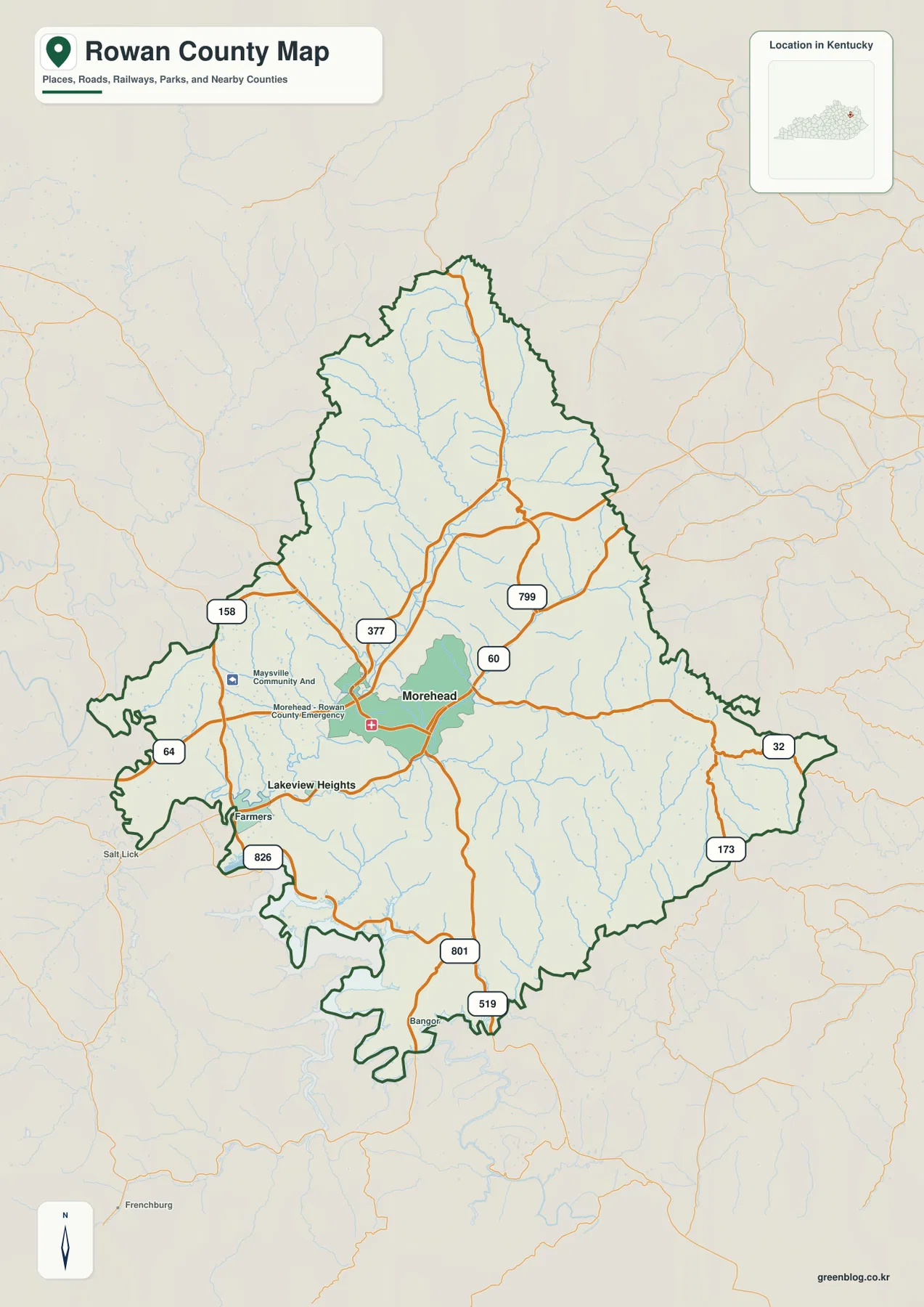
The general county map makes Morehead the obvious transportation reference point. I-64 enters from the west, passes through the central part of the county, and continues east, while U.S. 60 provides another major route through the Morehead area. KY 377 extends northward, with KY 158 and KY 799 serving the northwestern and northeastern sides. KY 32 reaches toward the eastern boundary, and KY 801 and KY 519 run south from the central area into the more heavily dissected southern uplands. The result is a road network that radiates through valleys rather than forming a simple grid.
That road pattern becomes easier to understand when it is compared with the elevation surface. Around Morehead and Triplett Creek, lower green terrain forms a relatively continuous corridor, while tan and brown ridges rise quickly on both sides. Roads can follow these lower passages for longer distances, but routes that move toward the north, east, or southeast encounter narrower valleys and more frequent ridge crossings. The county map therefore works as more than a road index: it provides the framework for seeing how transportation and terrain fit together.
West and southwest of Morehead, the map labels Lakeview Heights and Farmers, with Salt Lick appearing beyond the county edge. Those names are useful because they anchor the irregular western boundary to recognizable places. East of Morehead, the road system continues toward Carter County, while the northern routes lead toward Bath and Lewis counties. A reader can use Morehead as the center and trace outward in each direction without losing the county boundary, which is especially helpful when comparing neighboring areas.
The outline itself is distinctive. The northern end narrows before widening through the middle, and the southern half has several deep indentations and projecting sections. The eastern edge also extends outward in a long point. Because the boundary is irregular, a road that looks close to the edge may still remain inside Rowan County for some distance, while another route can cross into a neighboring county quickly. This is a reference map rather than a live navigation product, so current closures, construction, and turn-by-turn routing should be checked with up-to-date transportation services.
Morehead and Lakeview Heights define a simple settlement pattern
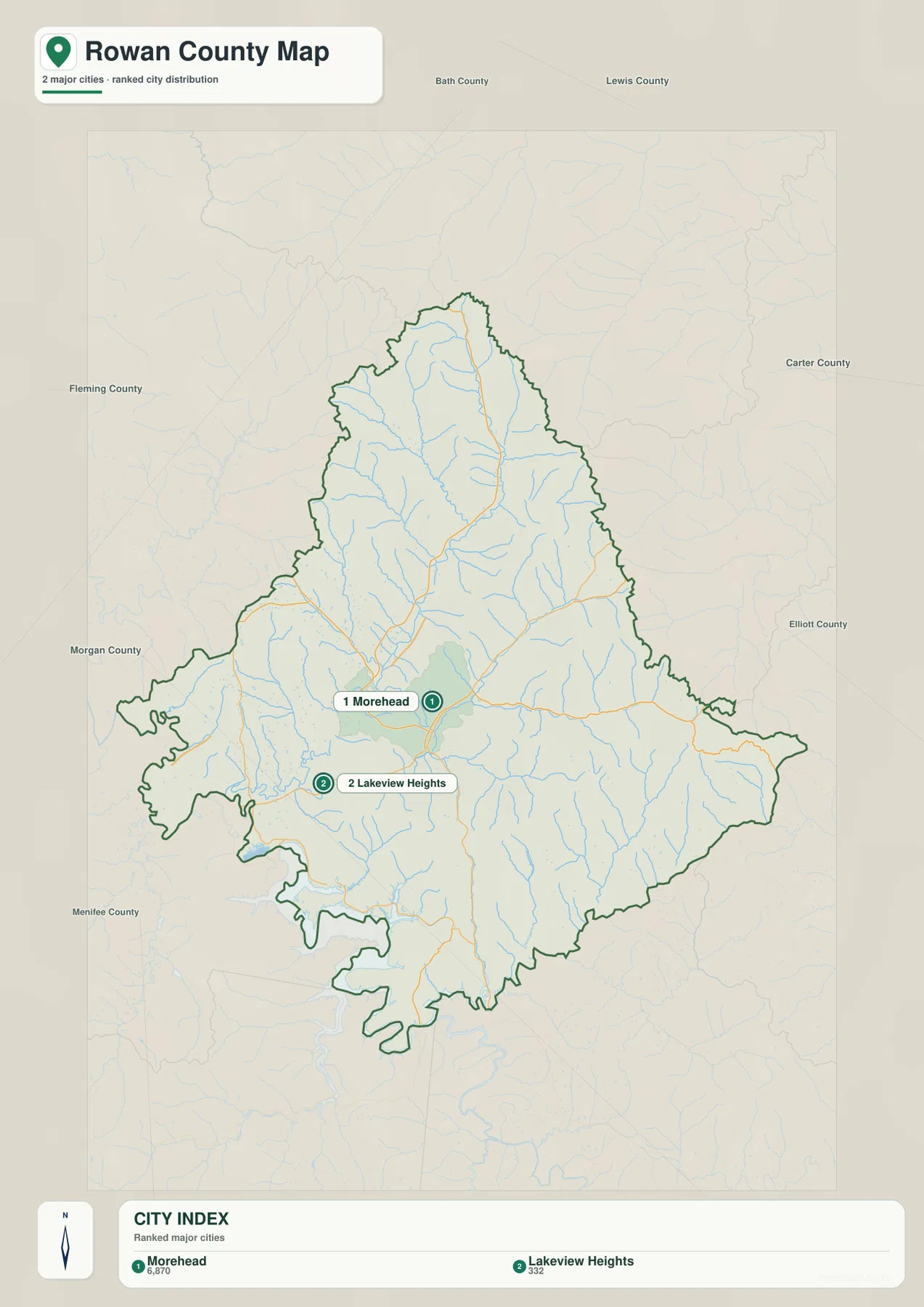
The city map deliberately removes much of the road detail and focuses on two ranked settlements. Morehead is shown as number one and Lakeview Heights as number two, with index values of 6,870 and 332 printed at the bottom of the map. Those figures should be treated as the values used by the map’s city index rather than as a claim about current official population. The geographic relationship is the more durable point: Morehead occupies the central valley, while Lakeview Heights lies a short distance to the southwest in a separate part of the county.
Morehead’s position is reinforced by the other layers. The road map places it near I-64 and U.S. 60, the water map puts it near Triplett Creek and University Lake, and the elevation layer shows lower terrain extending through the same central corridor. The city is therefore not simply a label placed near the middle of the polygon. It sits where transportation, drainage, and relatively low terrain overlap, making it the easiest starting point for interpreting the county as a whole.
Lakeview Heights occupies a different setting to the southwest. On the general map, this side of the county is closer to Farmers, western local roads, and a broader low-water corridor near the county edge. When a reader only needs the relative positions of the two settlements, the city map is the cleanest file because it avoids small route numbers and minor water labels. When actual road choices matter, the general county map can then be used as the second step.
The neighboring county names make the map more useful for regional orientation. Bath and Lewis counties are identified along the north, Carter County lies to the east, Elliott County appears southeast, and Morgan, Menifee, and Fleming counties frame the western and southwestern sides. These labels show Rowan County as part of a larger northeastern Kentucky network. They also explain why Morehead functions as a practical reference point for movement in several directions rather than only within the county boundary.
Triplett Creek ties Morehead to a dense network of tributary valleys
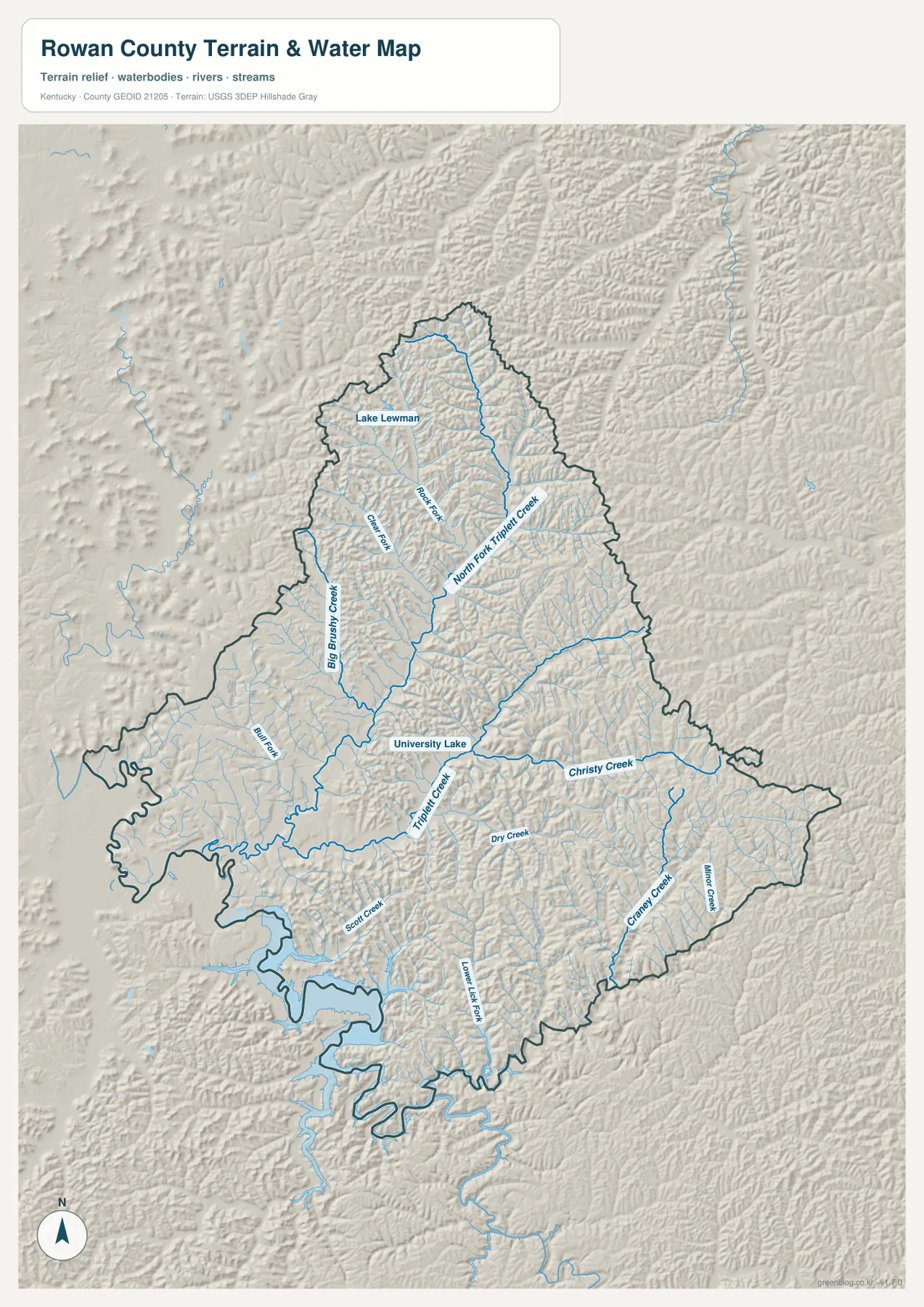
The terrain and water map reveals the county’s internal structure more clearly than the road layer. Triplett Creek runs through the central area, and North Fork Triplett Creek descends from the north before joining the broader drainage around Morehead. University Lake is labeled near the central valley, while Lake Lewman appears farther northwest. Neither lake dominates the county, but both serve as useful landmarks within a much larger pattern of narrow streams and ridge-bound valleys.
Several tributaries are labeled across the map. Big Brushy Creek and Clear Creek occupy the northwestern side, while Scott Creek appears farther southwest. Dry Creek, Christy Creek, Craney Creek, and Minor Creek are distributed across the eastern and southeastern sections. These names matter because the shaded relief shows that the blue stream lines consistently follow lower corridors between ridges. The drainage network is therefore also a guide to the terrain: every major creek marks a valley that helps divide the surrounding uplands.
North Fork Triplett Creek is especially useful for understanding the northern half of the county. It follows a long lower corridor between high ridges and receives numerous short tributaries from both sides. Farther east, Christy Creek crosses a similarly dissected landscape, while Craney Creek and Minor Creek occupy the southeastern ridges. The spacing of these streams makes clear why the county’s roads often bend along valleys instead of cutting directly across the higher terrain.
The southwestern side looks different. A broader low area and larger water shape appear near the county edge, with Scott Creek and nearby branches feeding toward it. Compared with the tight northern valleys, this section has a somewhat more open visual character. That contrast helps explain why a single county can contain both relatively broad low corridors near Morehead and the west, and narrow, closely spaced ridge-and-stream terrain toward the east.
This water layer is intended for county-scale geographic reference. It is not a flood hazard map, parcel map, legal water-boundary product, bathymetric chart, or navigation map, and small channels may be simplified at this scale. Property, safety, engineering, or regulatory decisions require current official source data. For general study, however, the file is valuable because it connects named creeks and lakes directly to the terrain that shapes them.
The 191–432 m elevation range follows long green valleys between ridges
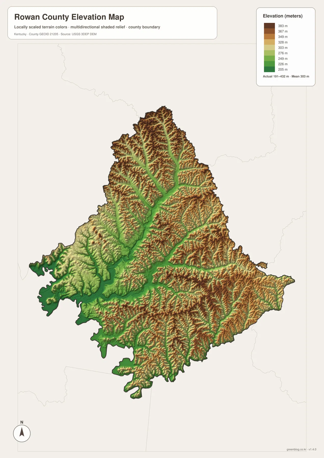
The elevation map reports an actual mapped range of about 191 to 432 meters and a mean near 303 meters. Green represents lower terrain within the county, while yellow-green, tan, and brown indicate progressively higher ground. The most important pattern is not a single high point but the branching system of low valleys. A green corridor follows the Morehead and Triplett Creek area and then splits north, east, and south along tributary valleys, with higher ridges filling the spaces between them.
In the north, higher ridges become prominent near the county edge, but North Fork Triplett Creek cuts a long lower passage through them. The eastern half contains an even denser texture of narrow ridges and valleys. Around Christy Creek, Craney Creek, and Minor Creek, green lines are tightly enclosed by higher brown slopes. That terrain matches the winding appearance of the eastern roads on the general map and makes the relationship between drainage and transportation easy to see.
The Morehead area is lower and more open by comparison, although it is not flat. The central green zone corresponds broadly with the city, I-64, U.S. 60, and the main Triplett Creek drainage. Southwest of the city, lower terrain also widens toward the western water system and the Lakeview Heights side of the county. Looking back and forth between the elevation and city maps shows why the principal settlement is concentrated in one part of Rowan County instead of being evenly distributed across the ridges.
Higher ground forms a connected ridge network rather than one isolated mountain mass. Brown crests branch across the northern, eastern, and southeastern portions of the county, with stream valleys separating them into narrow fingers. This map is therefore useful for describing relative relief even when the reader does not need exact elevation at every point. It shows where the county is more deeply dissected and where broader low corridors make roads, settlements, and water features easier to connect.
The elevation surface is generalized for county-scale interpretation and should not be used as survey-grade information for a building site, grading plan, engineering design, or precise slope calculation. Those applications require higher-resolution source data and professional measurement. For geographic orientation, education, and map comparison, the 191–432 meter range is useful because it places the lower Morehead corridor and the higher ridge country on the same visual scale.
Choosing the Rowan County file that matches the question
The general county map is the best all-purpose file when Morehead, Lakeview Heights, I-64, U.S. 60, KY 32, KY 801, other numbered routes, and the full county boundary need to appear together. The city map works better when the goal is a clean comparison of the two ranked settlements and neighboring counties. For Triplett Creek, North Fork Triplett Creek, University Lake, Lake Lewman, and smaller tributaries, the terrain and water map is the most informative. The elevation map removes much of the labeling and makes the difference between low valleys and high ridges the main subject.
- County map: use it for the Morehead road network, I-64 and U.S. 60, numbered Kentucky routes, settlement labels, and the complete county outline.
- City map: use it for a simple Morehead-Lakeview Heights comparison and for seeing the directions of surrounding counties.
- Terrain and water map: use it for Triplett Creek, North Fork Triplett Creek, University Lake, Lake Lewman, and the county’s smaller creek valleys.
- Elevation map: use it to compare the lower Morehead corridor with the higher northern, eastern, and southeastern ridges across the 191–432 m range.
For a printed handout or presentation, one or two maps are often clearer than placing all four on a single page. The county and city maps pair well for transportation and settlement topics. The water and elevation maps make a stronger pair for physical geography because the creek valleys can be matched directly to lower terrain. Each original JPG is 2572 × 3638 pixels, giving more room to inspect route numbers, smaller creek labels, and shaded ridge details than the reduced web previews provide.
A useful reading sequence is to find Morehead first, trace I-64 and U.S. 60, move to Triplett Creek and University Lake, and then compare the same area on the elevation map. From there, follow North Fork Triplett Creek north or Christy and Craney creeks east and southeast to see how quickly the valleys narrow. That sequence turns the four files into one geographic explanation of Rowan County rather than four separate versions of the same map.
Frequently Asked Questions
Which map is best for comparing Morehead and Lakeview Heights?
The city map is the clearest choice because it highlights Morehead as the first-ranked center and Lakeview Heights as the second while keeping neighboring counties visible. Use the general county map alongside it when you also need I-64, U.S. 60, numbered state routes, and the actual road network.
Which file shows Triplett Creek, University Lake, and Lake Lewman together?
Use the terrain and water map. It shows Triplett Creek and North Fork Triplett Creek together with University Lake, Lake Lewman, Big Brushy Creek, Christy Creek, Craney Creek, and other tributaries, making it the strongest file for understanding the county’s drainage and valley pattern.
Can the 191–432 meter elevation map be used for site or engineering measurements?
No. The elevation map is a generalized county-scale surface intended to compare lower valleys with higher ridges. Its range of about 191 to 432 meters and mean near 303 meters are useful for regional interpretation, but exact site elevations, grades, drainage design, or construction decisions require higher-resolution source data and professional surveying.
Sources and reference information
Map observations are based on the supplied Rowan County assets. Regional context and geographic data references were cross-checked with the local tourism commission and official U.S. boundary, hydrography, and elevation resources.
- Morehead-Rowan County Tourism — Local information about Morehead and Rowan County, outdoor recreation, Cave Run Lake, and regional attractions.
- U.S. Census Bureau TIGER/Line Shapefiles — Official U.S. geographic resources for county boundaries, roads, and related map layers.
- USGS National Hydrography — Official reference data for rivers, streams, lakes, and related hydrographic features.
- USGS 3D Elevation Program — Official U.S. elevation data and terrain-model information.
Map File Information
The ZIP contains the original high-resolution JPG versions of the Rowan County road and boundary map, city map, terrain and water map, and elevation map. Review Morehead, the main highways, Triplett Creek, local lakes, and the ridge pattern on the page, then select the file that best fits your printing or reference needs.
- File Type: ZIP containing 4 JPG files
Related Maps
Green Map creates custom-edited map images using open geographic data sources such as geoBoundaries, Natural Earth, OpenStreetMap, and government open data. These maps are edited visual materials, not raw data files, and are provided for education, documents, presentations, and graphic reference.