Magoffin County is a deeply dissected eastern Kentucky county where narrow creek valleys and closely spaced ridges shape nearly every part of the map. Salyersville is the clearest settlement reference near the center, with routes 460, 40, and 114 connecting the town to outlying valleys. The Licking River and a dense network of forks and branches occupy the low ground, while ridges rise sharply on both sides. This page explains the roads, settlement pattern, waterways, and elevation shown on the supplied maps, and the original high-resolution JPG map files can be downloaded together in a ZIP archive for printing, classroom work, presentations, or offline reference.
The county’s official website describes Salyersville as a community on the banks of the Licking River, which matches the geography visible on the map. Logville provides a northern reference, Gunlock marks the long southeastern extension, and the historic Right Middle Fork label helps orient the western side. Magoffin County is not organized around several large towns; instead, roads and smaller communities follow long valleys through rugged terrain. That makes water and elevation just as important as place names when trying to understand the county.
Table of Contents
Routes 460, 40, and 114 organize travel around Salyersville
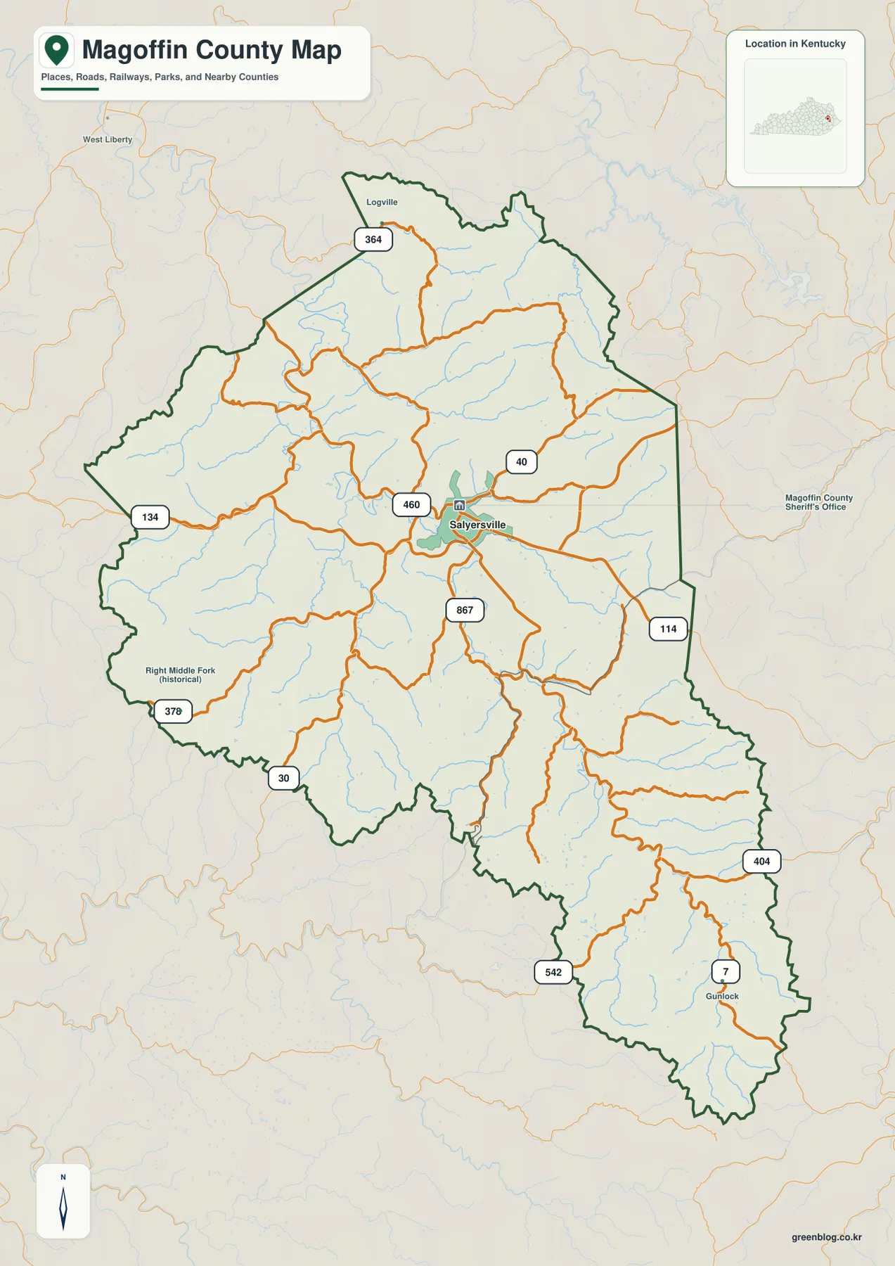
Salyersville is the easiest place to find on the general county map. Route 460 crosses the central part of the county, route 40 heads east from the town area, and route 114 follows the eastern side for a considerable distance. Route 867 extends south from the central corridor, and farther southeast the road network includes routes 404, 542, and 7 around the Gunlock area. The roads rarely follow straight lines because most of them stay within valleys between long ridges.
In the north, route 364 passes near Logville. Route 134 reaches the western boundary, while routes 378 and 30 serve the southwestern side. These roads connect areas that appear close on a small map but are separated by repeated ridge lines. The orange road pattern often parallels the blue stream network, showing how transportation in Magoffin County has to work with the terrain rather than cutting directly across it.
The county outline itself is irregular. Northern and western boundaries bend several times, and the southeastern end narrows into a long extension toward Gunlock. Salyersville therefore does not sit at the midpoint of a simple compact shape. The general map is especially useful for seeing how the central road network relates to distant valleys at the northern, western, and southeastern edges.
This map is a geographic reference rather than a live navigation product. It does not show current construction, temporary closures, or real-time travel conditions. In a county with steep ridges and narrow valleys, driving distance can be much longer than the apparent straight-line separation between two points.
One ranked major city places Salyersville at the center of the settlement pattern
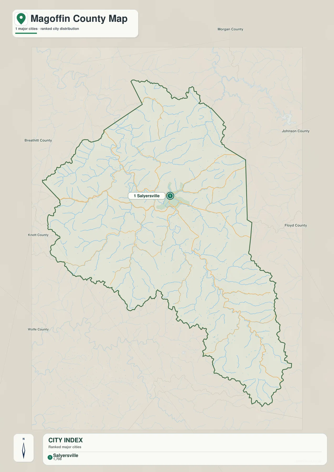
The city-distribution map identifies Salyersville as the single ranked major city and labels its population as 1,708. That solitary city marker is striking because the county covers a much larger area filled with small roads, creeks, and ridges. Salyersville sits slightly north of the county’s geographic middle, making it a practical reference for both the northern and southern parts of Magoffin County.
Neighboring county labels help place the county in context. Morgan County lies to the north, Johnson County to the northeast, and Floyd County along the eastern and southeastern side. Breathitt County is to the west, while Knott and Wolfe counties appear toward the southwest. The distribution map therefore does more than identify Salyersville; it shows how Magoffin County is enclosed by other rugged eastern Kentucky counties.
A single ranked city does not mean the rest of the county is uninhabited. The general map includes smaller named places such as Logville and Gunlock, and numbered roads reach into many narrow valleys. The city map is intentionally simplified, so it works best for identifying the main urban center while the road map provides the finer settlement detail.
Once Salyersville is fixed as the main reference point, the physical maps become easier to follow. The Licking River and several tributaries converge in the central part of the county, and the elevation surface shows broad low valleys surrounded by higher ridge systems. Settlement, water, and terrain therefore fit together rather than appearing as separate map topics.
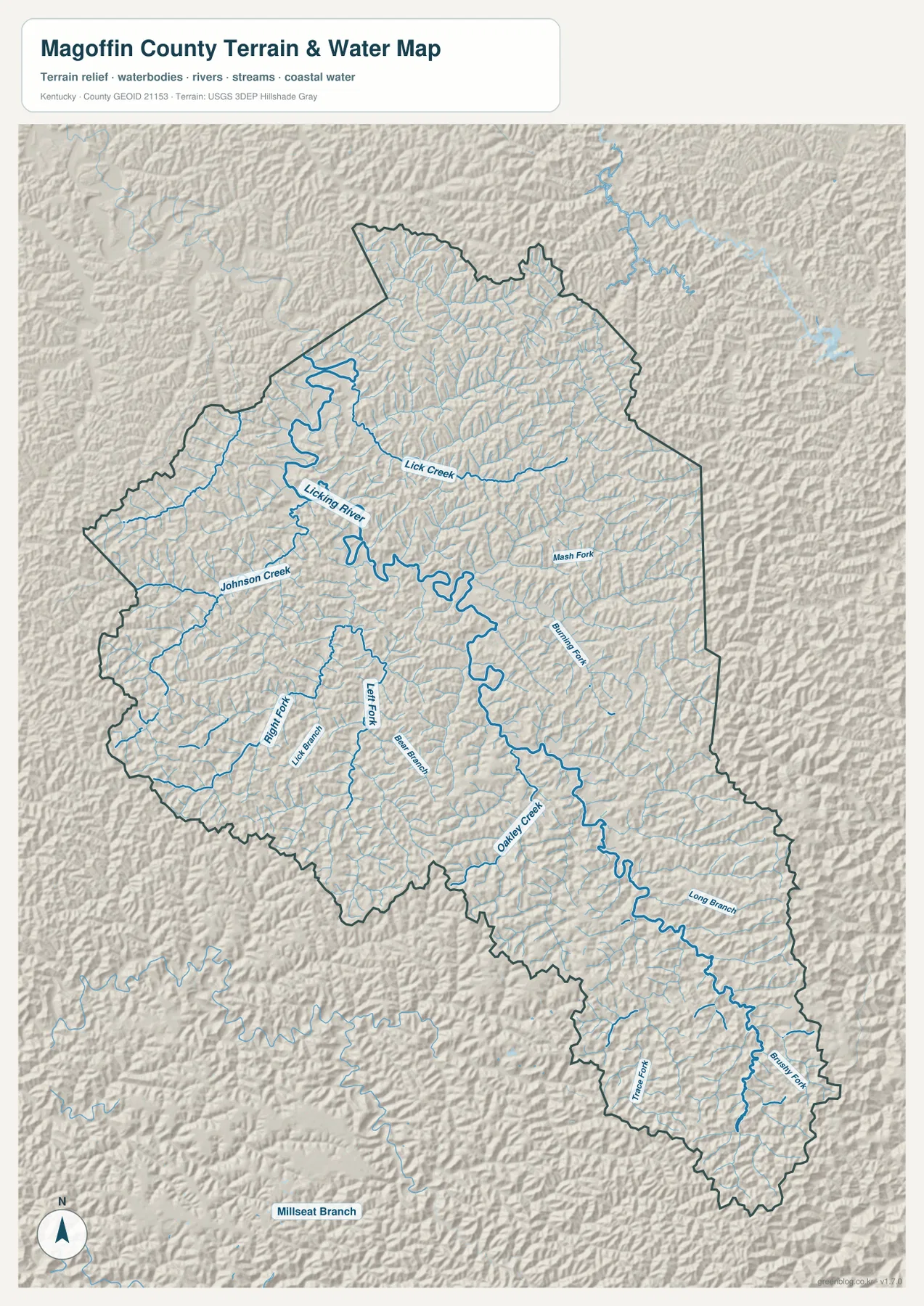
Licking River, forks, and branches fill the county’s narrow valleys
The terrain-and-water map is dominated by the Licking River, which crosses the northern and central parts of Magoffin County. Lick Creek approaches from the northeast, while Johnson Creek enters from the west. South of the main river corridor, Left Fork and Right Fork extend through long valleys, with Lick Branch and Bear Branch occupying additional low cuts between the ridges. The number of tributaries makes the county look almost entirely organized around drainage valleys.
Farther east, Mash Fork and Prater Fork provide additional reference lines. Oakley Creek becomes the most prominent named waterway in the southeastern interior, and Long Branch reaches in from the east. Near the southern end, Trace Fork and Brush Fork follow narrow mountain valleys. Numerous unnamed tributaries fill the spaces between them, reinforcing the impression of a landscape carved into many small watersheds.
The Licking River is especially important for understanding Salyersville. The official county site describes the community as being on the river, and the map shows tributaries gathering toward the same central area. Starting with the Licking River, then locating Johnson Creek and Lick Creek, and finally following Left Fork, Right Fork, and Oakley Creek is an easy way to make sense of the otherwise dense water network.
This map is designed for geographic orientation, not for flood forecasting, navigation, water depth, fishing rules, or access decisions. Anyone planning an activity near a stream or river should use current information from the agencies responsible for water conditions and public safety.
Elevation from 226 to 500 meters reveals a county of ridges and hollows
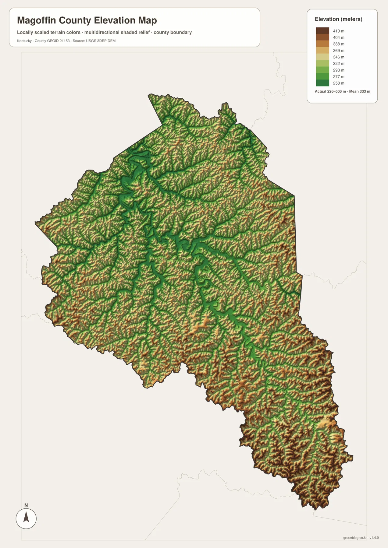
The elevation map reports an actual range of about 226 to 500 meters and a mean near 333 meters. Lower green terrain follows the Licking River and major tributary valleys, while yellow, orange, and brown ridges repeat across nearly the entire county. There are very few broad flat areas. Instead, long narrow uplands stand between equally narrow stream valleys, giving Magoffin County a strongly corrugated appearance.
The central and northwestern sections contain some of the broadest connected low valleys, including the Salyersville area. Elevation rises quickly away from those corridors, however, and ridge crests appear only a short distance from the streams. This close alternation explains why roads and waterways often curve in similar directions: routes tend to remain in lower terrain rather than crossing every ridge directly.
The southeastern extension toward Gunlock shows an especially tight pattern of valleys and high ground. Long creek corridors are bordered by repeated ridge lines, and the southern tip contains some of the most rugged-looking terrain on the map. Northern Magoffin County is also hilly, but the central Licking River corridor creates a somewhat broader low route through the county than many of the southeastern valleys.
The elevation colors are intended for county-scale comparison and should not be treated as survey-grade measurements for a parcel, road, structure, or construction site. Engineering, drainage design, and legal surveying should rely on current source elevation data or professional field measurements. For general geographic use, the map clearly shows how little flat ground exists away from the main valleys.
Following the maps from Salyersville to Gunlock
A practical way to read Magoffin County is to begin in Salyersville. On the road map, locate routes 460 and 40, then note route 114 along the eastern side. On the water map, find the Licking River and Lick Creek near the same central area. The elevation map then shows why this location became an important crossroads: the town occupies comparatively low ground where several valleys come together.
Moving southeast, route 867 provides an early road reference before routes 404, 542, and 7 appear closer to Gunlock. The water map adds Oakley Creek, Long Branch, Trace Fork, and Brush Fork along this direction. On the elevation map, those same corridors appear as green valleys separated by repeated high ridges, making the long southeastern shape of the county much easier to understand.
The northern side can be read from Logville and route 364, while routes 134, 378, and 30 help orient the west and southwest. The historic Right Middle Fork label is another useful reference on the general map. Following these named points outward from Salyersville prevents the county from becoming a confusing collection of similar-looking valleys.
Choosing the most useful map for class, print, or local reference
Use the general county map when you need Salyersville, smaller named places, numbered roads, and the complete county boundary in one view. The city-distribution map is better for a simplified explanation of why Salyersville is the main urban reference and how Magoffin County sits among its neighboring counties. Each view answers a different practical location question without requiring the reader to sort through every layer at once.
Choose the terrain-and-water map when river and creek names matter. It is the best place to find the Licking River, Johnson Creek, Lick Creek, Oakley Creek, and the many forks and branches that divide the county. The elevation map is more useful for showing why those waterways and roads follow such winding routes, because it makes the close spacing of valleys and ridges immediately visible.
The WebP images in the article are optimized for browser viewing. The downloadable ZIP contains the original JPG maps at 2,572×3,638 pixels each, making them better suited to printing, worksheets, presentations, and offline use. These maps are general geographic references rather than legal boundary records, flood studies, parcel surveys, or engineering plans.
Frequently Asked Questions
Where is Salyersville within Magoffin County?
Salyersville is near the central part of the county, slightly north of the midpoint, where routes 460 and 40 meet several local roads. It is also closely tied to the Licking River corridor. Because the city sits where several valleys come together, it is the easiest starting point for understanding the road, water, and elevation maps.
Which map best shows the Licking River and Oakley Creek together?
The terrain-and-water map is the best choice. It shows the Licking River across the northern and central county and Oakley Creek farther southeast, along with Johnson Creek, Lick Creek, Left Fork, Right Fork, Long Branch, Trace Fork, and other tributaries.
Can the 226–500 meter elevation range be used for exact property heights?
No. The range summarizes the actual countywide elevations shown on the map, with a mean near 333 meters. It is useful for comparing low creek valleys with surrounding ridges, but exact site elevations should come from current source data or professional surveying.
Map File Information
The ZIP archive contains the original high-resolution JPG versions of the Magoffin County road-and-boundary map, city-distribution map, terrain-and-water map, and elevation map. Each image is 2,572×3,638 pixels for printing, classroom work, presentations, and offline reference.
- File Type: 4 JPG files inside one ZIP archive
Related Maps
Sources and references
County background is available from the official Magoffin County website and the Kentucky.gov Magoffin County profile. For underlying geographic data, see the U.S. Census Bureau TIGER/Line Shapefiles for boundaries and roads, USGS National Hydrography for rivers and streams, and the USGS 3D Elevation Program for elevation data.
These maps are intended for geographic explanation, printing, and general reference. Legal boundary decisions, live traffic, flood safety, property surveying, and engineering work should rely on the latest authoritative information from the responsible public agency.
Green Map creates custom-edited map images using open geographic data sources such as geoBoundaries, Natural Earth, OpenStreetMap, and government open data. These maps are edited visual materials, not raw data files, and are provided for education, documents, presentations, and graphic reference.