Lyon County sits in western Kentucky where broad reservoirs, river corridors, and deeply indented shorelines shape much of the county. Eddyville and Kuttawa are close together in the north-central area, while the southern half is dominated by Lake Barkley and long water-filled valleys. The Cumberland River feeds the Lake Barkley system through the middle of the county, and the Tennessee River runs along the western and southwestern side. This page explains the towns, roads, waterways, ridges, and lowlands shown on the supplied maps, and the original high-resolution JPG map files can also be downloaded together in one ZIP archive.
The contrast between north and south is immediately visible. Northern Lyon County has more continuous land crossed by many small streams, whereas the southern half is broken into peninsulas, narrow ridges, bays, and long arms of water. Roads around Eddyville and Kuttawa form the clearest settlement network, but farther south the shoreline and terrain become the main geographic reference points. Comparing the general map with the water and elevation views makes it much easier to understand why routes curve and why large parts of the county have few major urban labels.
Table of Contents
Roads and settlements centered on Eddyville and Kuttawa
Eddyville is the easiest place to locate on the general county map. Route 69 crosses the city area, while routes 295 and 641 approach from the west and north. The Lyon County Emergency Medical marker gives another recognizable point near town. Kuttawa lies west of Eddyville and closer to the Lake Barkley shoreline, with route 62 continuing toward the Grand Rivers side of the region. Although the two cities are geographically close, the surrounding road connections and water barriers send traffic in different directions.
Southeast of Eddyville, routes 818 and 293 branch through the interior. Farther down the eastern side, routes 903, 24, and 93 create a longer north-south corridor, and route 274 appears near the southern boundary. Route 453 runs through the southwestern part of the county, while 855 is visible toward the northwest. The road system therefore changes from a denser town-centered pattern in the north to longer corridors that weave among lakes, coves, and ridges in the south.
Nearby place names outside the boundary provide useful orientation. Fredonia and Princeton appear north and northeast, while Grand Rivers lies to the west near the large river-and-lake junctions. The city-distribution map also labels neighboring Crittenden, Caldwell, Trigg, Marshall, and Livingston counties. These references show that Lyon County occupies a transition between more continuous upland counties to the north and a strongly water-shaped landscape to the south and west.
The general county map is best when towns, numbered roads, nearby places, and the full county outline need to be seen together. It is not a live navigation product, however. Current construction, closures, bridge conditions, and driving times should be checked with up-to-date transportation sources, especially because a short straight-line distance can require a longer road trip around water.
A two-city pattern concentrated in the north-central county
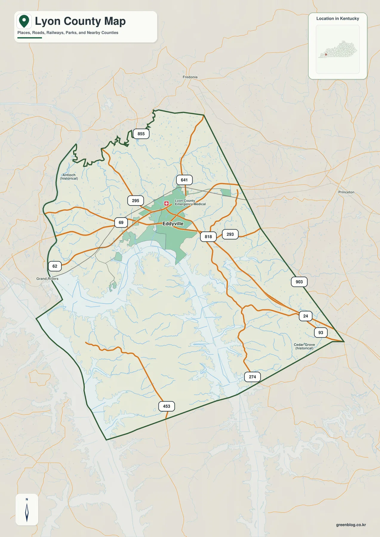
The city-distribution map identifies two ranked major cities: Eddyville and Kuttawa. Eddyville is listed first with a population label of 2,897, and Kuttawa is second with 588. Both are clustered in the north-central portion of Lyon County rather than spread evenly across the full county. That concentration becomes more striking when the large southern half is considered, because the land there is fragmented by Lake Barkley, river corridors, and narrow ridges instead of being organized around another comparable city center.
Eddyville lies slightly inland at the core of the road network, while Kuttawa sits closer to the broad water edge. On the general map, route 69 connects the two areas and several smaller routes branch away toward the north, east, and southwest. The city map deliberately removes most of those details so the settlement pattern stands out: two principal towns close together near the northern edge of a much larger water-dominated county.
South of the two cities, geographic orientation depends more on coves, rivers, and roads than on urban names. Lake Barkley widens through the center, and the land breaks into long fingers between water arms. The city map is therefore useful for understanding where the population centers are concentrated, but it cannot explain the southern half on its own. The terrain-and-water and elevation maps provide the missing context.
The population labels are helpful as scale markers rather than the central subject of the page. Once Eddyville and Kuttawa are located, the reader can move outward to the Cumberland River, Lake Barkley, Tennessee River, and the ridge systems east and south of the cities. That sequence gives a clearer picture of Lyon County than treating the county as a simple pair of towns.
Lake Barkley, Cumberland River, and a maze of bays
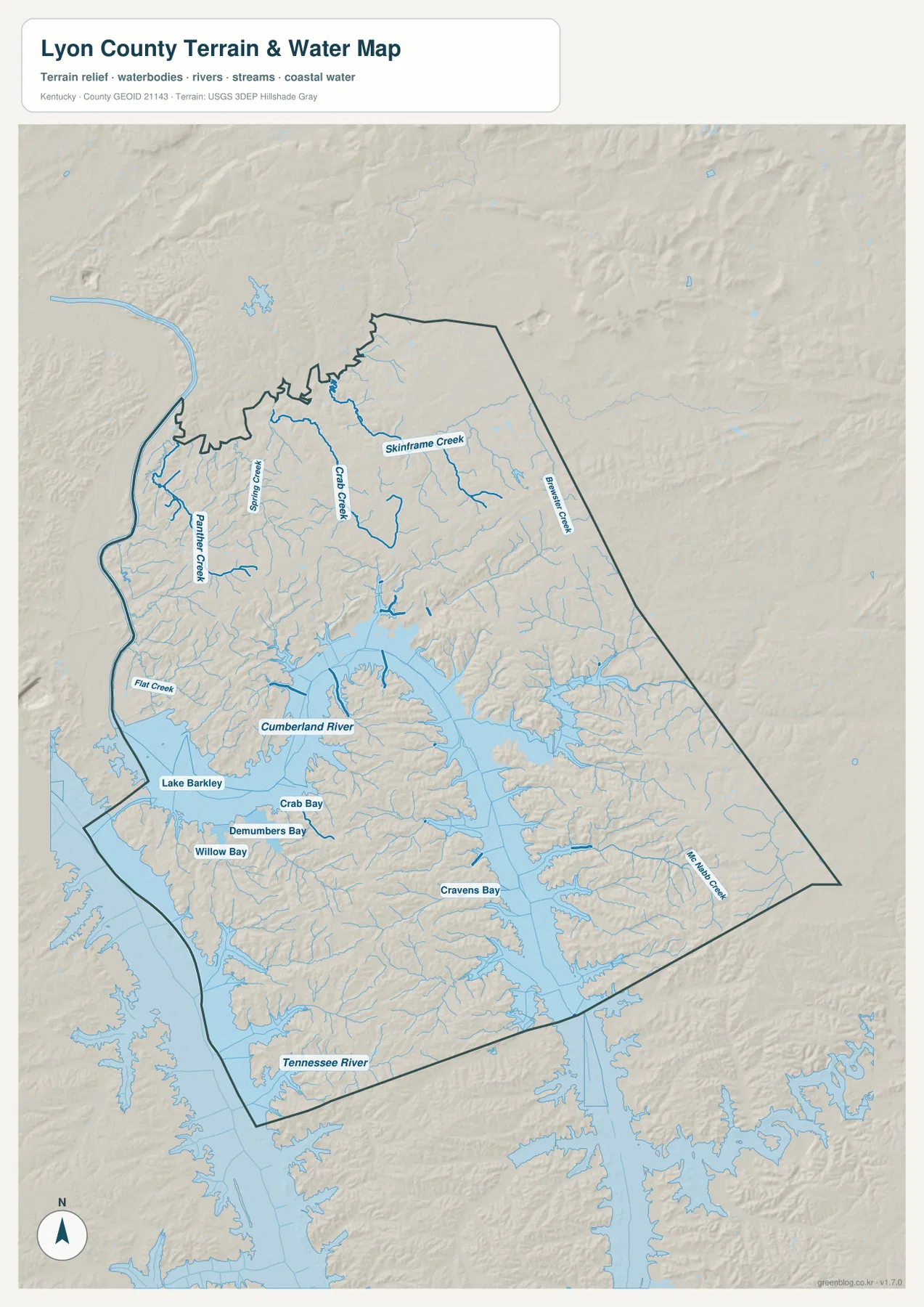
The terrain-and-water map shows the feature that most strongly defines southern Lyon County: Lake Barkley. The Cumberland River enters the broad reservoir system through the middle of the county, while the Tennessee River follows the western and southwestern side. Between and around those large water corridors, the shoreline branches repeatedly into long coves and narrow drowned valleys. Crab Bay, Demumbers Bay, Willow Bay, and Cravens Bay are among the clearest named examples.
North of the reservoir, smaller streams create a different pattern. Spring Creek and Palmer Creek appear in the northwest, Crabb Creek and Skinframe Creek cross the north-central interior, and Beulah Creek lies closer to the eastern boundary. Flat Creek reaches toward Lake Barkley on the western side. These tributaries occupy lower valleys between ridges, so their directions closely match the green low corridors visible on the elevation map.
The named bays make the southern shoreline easier to understand. Demumbers Bay and Willow Bay sit on the western side of the main lake system, Crab Bay lies farther north, and Cravens Bay reaches deep into the southern interior. Numerous smaller arms extend beyond those labels. The result is a county where the water-land boundary is extraordinarily long compared with a simple straight shoreline, and many narrow ridges end at the reservoir.
This physical map is designed for geographic reference. It does not report current lake level, flood conditions, channel depth, boating restrictions, fishing rules, or private-property access. Anyone planning on-the-water activity should use current information from the agencies responsible for navigation, recreation, and safety.
Elevation from 98 to 204 meters around the reservoir valleys
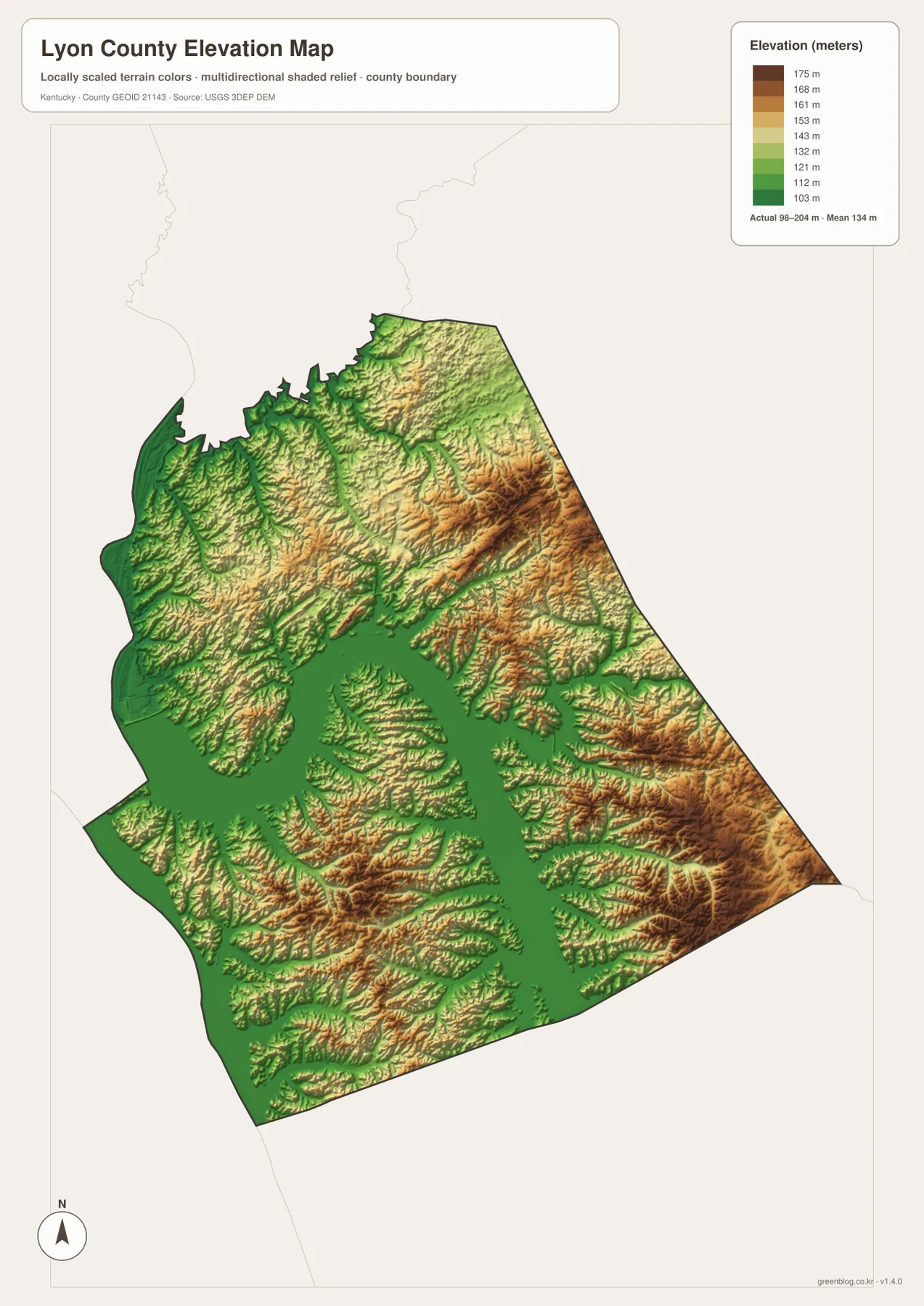
The elevation map reports an actual county range of about 98 to 204 meters, with a mean near 134 meters. The lowest green terrain follows Lake Barkley, the Tennessee River, and the many narrow stream valleys feeding the reservoir. Higher orange and brown ridges are much more common in the eastern and southeastern parts of the county, with additional uplands visible in the northeast. The contrast is sharp because long reservoir arms penetrate deep into the hills.
Low ground around Lake Barkley is not one continuous flat plain. Green corridors branch outward along creeks and bays, separating narrow yellow and brown ridges. Around Willow Bay, Demumbers Bay, and Cravens Bay, those ridges repeatedly project toward the water. Comparing the water and elevation maps makes the pattern clear: many of the reservoir arms occupy pre-existing low valleys, while the higher land between them remains as peninsulas and ridge spurs.
The eastern boundary stands out as a more consistently elevated zone. Roads 93 and 24 pass through parts of this hillier side, and the southeast contains some of the darkest brown areas on the map. Northern Lyon County is also dissected by many small valleys, although the relief is less dominated by large open water. That combination explains why the county can look relatively compact on a boundary map but much more rugged and broken on the elevation surface.
The color scale is intended for county-level comparison, not site surveying. It is useful for distinguishing lake lowlands, creek valleys, and higher ridges, but it should not be treated as an exact elevation for a parcel, road, structure, or construction site. Engineering, drainage design, and legal surveying should rely on current source elevation data or professional field measurements.
Following Lyon County from Eddyville into the southern lake country
Eddyville is a practical starting point for moving between the map views. On the road map, routes 69, 295, and 641 establish the town’s position and show how Kuttawa lies to the west. On the water map, the Cumberland River and Lake Barkley broaden immediately south of the settlement area. The elevation map then shows the same shorelines as low green corridors, with higher terrain increasing toward the east.
Kuttawa offers a useful western comparison. Route 62 leads toward the Grand Rivers side, and the city sits close to the broad reservoir edge. South of Kuttawa, Demumbers Bay and Willow Bay cut deeply into the land. The elevation view shows long ridges between those bays, so what looks like a simple shoreline on a small-scale map becomes a sequence of narrow uplands and water-filled valleys.
Farther southeast, cities become less useful as landmarks and roads such as 93, 24, 274, and 453 take over as reference lines. Cravens Bay reaches into the southern interior, while the eastern boundary rises into higher ridge country. Moving from north to south therefore reveals one of Lyon County’s strongest transitions: continuous upland land with small streams gradually gives way to a landscape dominated by open water, coves, peninsulas, and narrow ridges.
Choosing the right Lyon County map for the task
Use the general county map when Eddyville, Kuttawa, numbered roads, nearby towns, and the county boundary need to be seen together. The city-distribution map is better when the question is simply where the two major cities are concentrated and how they relate to the much larger southern portion of the county. It removes most road detail and makes the settlement pattern immediately obvious.
Choose the terrain-and-water map for Lake Barkley, the Cumberland River, Tennessee River, named bays, and tributary creeks. It is the strongest view for explaining why southern Lyon County has such a complicated outline. Choose the elevation map when the focus is relief rather than water names. The green reservoir corridors and higher eastern ridges become much easier to compare when the physical maps are placed side by side.
The WebP images in the article are optimized for browser viewing. The downloadable archive contains the original JPG maps at 2,572×3,638 pixels each, making them better suited to printing, worksheets, presentations, and offline reference. These are general geographic maps rather than legal boundary records, flood studies, navigation charts, parcel surveys, or engineering plans.
Frequently Asked Questions
Where are Eddyville and Kuttawa located within Lyon County?
Both major cities are concentrated in the north-central part of the county. Eddyville is slightly more inland at the road-network center, while Kuttawa sits closer to Lake Barkley. The large southern half has few comparable urban labels and is instead dominated by reservoir arms, rivers, and ridges.
Which map best shows Lake Barkley and the Tennessee River together?
The terrain-and-water map is the best choice. It shows the Cumberland River and Lake Barkley through the center and south, with the Tennessee River along the western and southwestern side. Crab Bay, Demumbers Bay, Willow Bay, Cravens Bay, and several named creeks provide additional reference points.
Does the 98–204 meter elevation range provide survey-grade heights?
No. It summarizes the actual countywide elevation range shown on the map, with a mean near 134 meters. The map is useful for distinguishing low reservoir valleys from higher eastern and southeastern ridges, but exact site elevations should come from current source data or professional surveying.
Map File Information
The ZIP archive contains the original high-resolution JPG versions of the Lyon County road-and-boundary map, city-distribution map, terrain-and-water map, and elevation map. Each image is 2,572×3,638 pixels for printing, classroom work, presentations, and offline reference.
- File Type: 4 JPG files inside one ZIP archive
Related Maps
Sources and references
County government and local background are available from the official Lyon County website and its About Lyon County page. For underlying geographic data, consult the U.S. Census Bureau TIGER/Line Shapefiles for boundaries and roads, USGS National Hydrography for rivers, lakes, and streams, and the USGS 3D Elevation Program for elevation data.
These maps are intended for geographic explanation, printing, and general reference. Legal boundary decisions, live traffic, boating safety, flood risk, parcel questions, surveying, and engineering work should rely on the latest authoritative information from the responsible public agency.
Green Map creates custom-edited map images using open geographic data sources such as geoBoundaries, Natural Earth, OpenStreetMap, and government open data. These maps are edited visual materials, not raw data files, and are provided for education, documents, presentations, and graphic reference.