Logan County covers a broad part of southwestern Kentucky, with Russellville near the center and Lewisburg, Auburn, and Adairville spread in different directions around it. The general map shows the county boundary, main roads, and settlement pattern, while the physical maps make the lakes, streams, hills, and lower river country easier to recognize. Lake Malone stands out in the northwestern corner, and the Red River system marks the southern side of the county. High-resolution JPG versions of the maps can also be downloaded in one ZIP archive for printing, classroom use, presentations, or offline reference. High-resolution map files are available for download in the section below.
Russellville is the strongest orientation point because several numbered roads meet there and the other highlighted towns are distributed around it. Lewisburg lies northwest, Auburn is east, and Adairville is south. Waterways cut through all of those areas, and the elevation map shows that the county is not uniformly flat: ridges are especially visible in the north and east, while lower ground follows major valleys and the Red River near the southern boundary.
Table of Contents
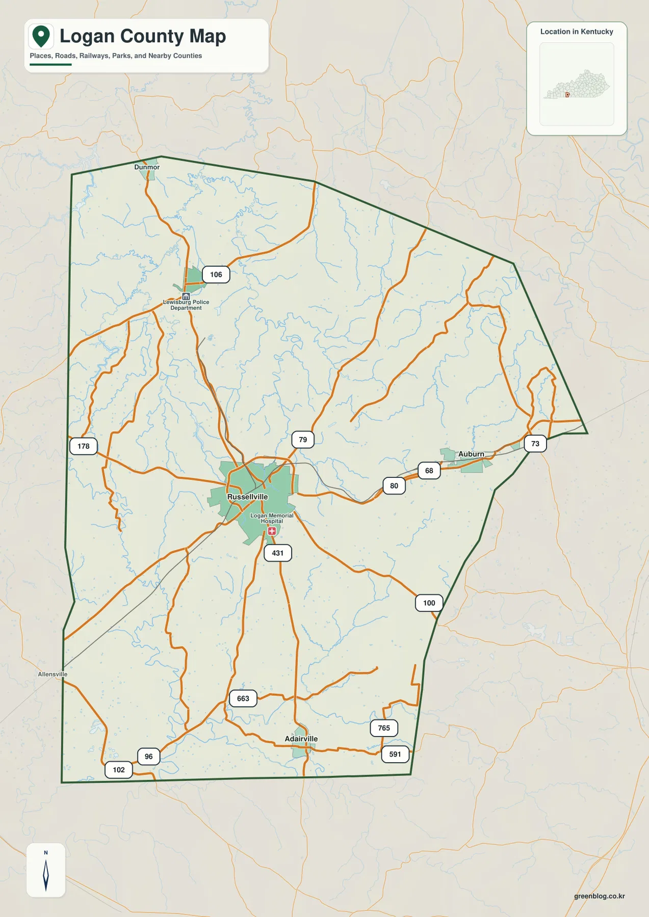
Roads radiating from Russellville across Logan County
Russellville is the easiest place to begin on the county map. Routes 79 and 431 meet in the city area, and roads continue east toward Auburn, northwest toward Lewisburg, and south toward Adairville. Routes 80 and 68 are visible along the Auburn side, while 106 appears near Lewisburg. Farther south, routes 100, 663, 765, and 591 help trace the approach to Adairville and the Tennessee-facing edge of the county.
Lewisburg sits northwest of Russellville, and the map also marks the Lewisburg Police Department as a useful local landmark. Dunmor appears near the northern edge above Lewisburg. Auburn occupies the eastern side near routes 68 and 80, with route 73 closer to the county’s eastern boundary. Adairville lies near the south, where the road network becomes more closely associated with the lower river terrain shown on the physical maps.
The county map also makes the neighboring directions easier to understand. Butler County is north of the main mapped area, Simpson and Warren counties are to the east, Todd County is west, and Muhlenberg County appears to the northwest. Those surrounding labels help place Logan County in the larger western Kentucky road network without requiring a separate state map. For current driving, construction, or road-closure information, however, a live transportation source is more appropriate than this reference map.
Roads do not form a simple rectangular grid. Many of them bend through rolling country and cross a dense network of creeks. That is especially noticeable north of Russellville and toward the eastern hills. Comparing this road map with the water and elevation maps explains why some routes curve and why several towns developed at different points rather than along one single straight corridor.
How Lewisburg, Auburn, and Adairville relate to Russellville
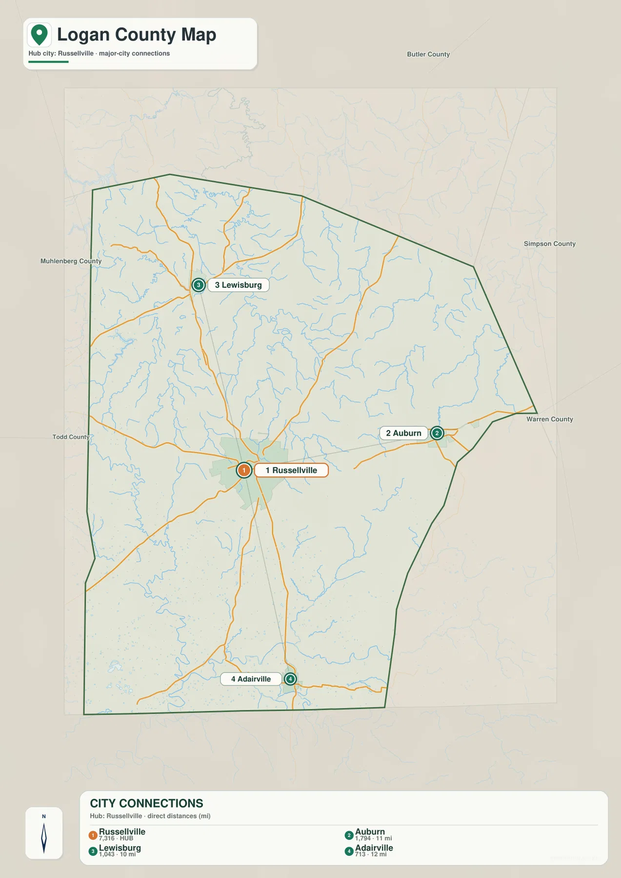
The city-connections map simplifies the road detail and focuses on the four highlighted settlement areas. Russellville is the hub. Lewisburg is northwest, Auburn is east, and Adairville is south. The map lists direct distances of about 10 miles from Russellville to Lewisburg, 11 miles to Auburn, and 12 miles to Adairville. These are straight-line distances between the mapped places, not driving distances along the road network.
Although the three distances are fairly similar, the surrounding landscapes are different. The Lewisburg side approaches the hillier northwestern part of the county and several small lakes and streams. Auburn is tied to the eastern uplands and roads 68 and 80. Adairville is closer to the southern lowlands and the Red River drainage. The simplified city map is therefore best for direction and relative spacing, while the other maps add the terrain that a straight connector line cannot show.
Population labels on the map distinguish Russellville from the smaller towns, but the main purpose of this graphic is geographic orientation rather than demographic comparison. Once the four places are familiar, other features become easier to locate. Lake Malone can be placed northwest of Russellville, Gasper River and Black Lick Creek are on the eastern side, and the Red River system lies near the southern edge.
Lakes and streams from Lake Malone to the Red River
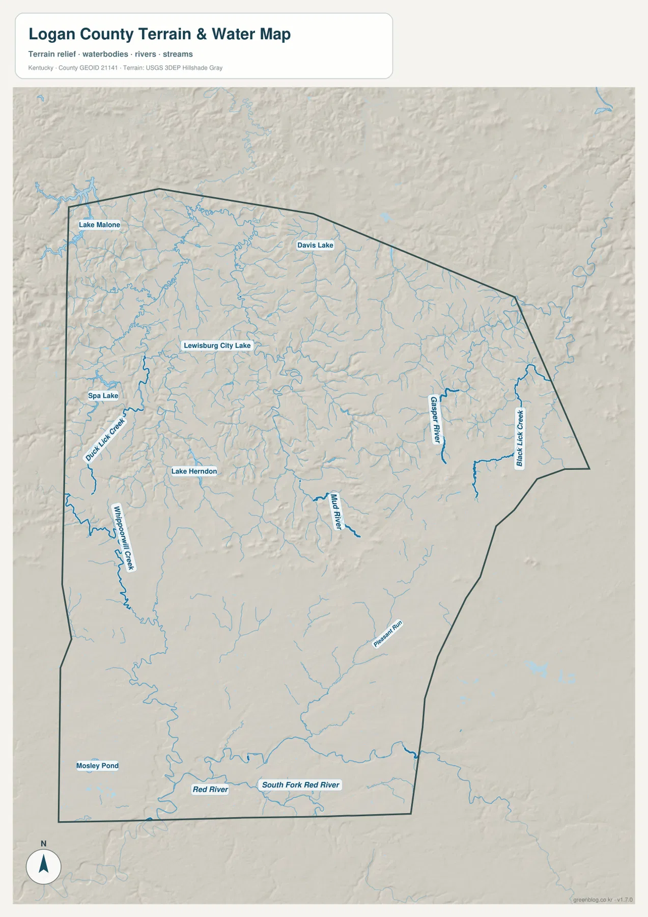
The terrain-and-water map reveals how densely Logan County is divided by streams. Lake Malone is the most prominent named water body in the northwestern corner. Lewisburg City Lake, Spa Lake, Lake Herndon, and Davis Lake provide additional reference points across the northern half. Duck Lick Creek and Whippoorwill Creek are labeled in the west, while Gasper River and Black Lick Creek stand out farther east.
Mud River appears in the central-southern interior and helps connect the middle of the county with the larger drainage system to the south. Pleasant Run is labeled in the southeast, and Mosley Pond sits in the southwest. Along the southern boundary, the Red River and South Fork Red River form the strongest water features. Their broad bends are especially useful when comparing the water map with the lower green terrain on the elevation map.
The northern half has many branching tributaries that cut between ridges. Around Lake Malone and Lewisburg City Lake, narrow valleys extend in several directions, creating a much more dissected landscape than the simple county outline suggests. On the eastern side, Gasper River and Black Lick Creek occupy separate valley systems. Those named waterways help organize the many smaller blue lines that would otherwise be difficult to follow.
This map is intended to show geographic relationships among rivers, creeks, lakes, and terrain. It does not provide current flood stages, water depth, boating rules, fishing regulations, water quality, or access rights. Anyone planning an activity on or near the water should use current information from the responsible agencies.
Elevation from 122 to 264 meters across the county
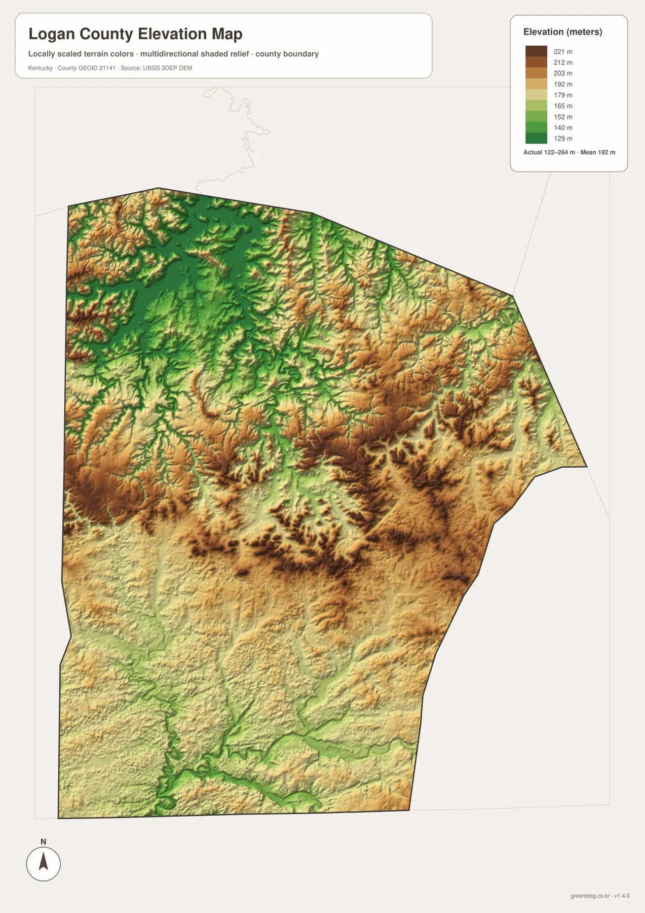
The elevation map reports an actual range of roughly 122 to 264 meters and a mean elevation near 182 meters. Higher brown and orange terrain is prominent in the northwest, east, and parts of the central interior. Lower green terrain follows several valleys and becomes especially broad near the southern river system. The result is a county of rolling relief rather than a uniformly level surface.
Near Lake Malone, narrow ridges and valleys appear in a closely packed pattern. Similar relief continues north and east of Lewisburg. The Auburn side also contains extensive higher terrain, but small green valleys cut through it repeatedly. Those valleys match many of the creeks shown on the water map, making the relationship between drainage and relief easy to see.
Russellville lies in a transition zone between the hillier northern and eastern areas and the lower country farther south. Moving toward Adairville and the Red River, lower colors become more extensive. The river corridors at the southern edge are among the clearest low areas on the map. This contrast helps explain why the southern part of the county looks more open on the elevation surface even though smaller ridges are still present.
The colored elevation surface is designed for county-scale comparison, not parcel-level measurement. It is useful for identifying ridges, valleys, and lower river corridors, but it should not be treated as survey-grade elevation for a building site, roadway, drainage design, or property boundary. Detailed work should rely on current source elevation data or field measurements.
Following the same place across all four map views
Russellville provides the easiest cross-map example. The road map shows routes 79 and 431 around the city and the connections toward Auburn, Lewisburg, and Adairville. The city map reduces that detail to direction and straight-line distance. The water map then adds nearby streams, while the elevation map shows that Russellville sits between more rugged uplands and lower southern terrain. Moving through the maps in that order builds a clear picture without requiring the reader to memorize every feature at once.
Lewisburg works well for the northwestern part of the county. Route 106 and the road network establish its position, Lewisburg City Lake and nearby streams add the water context, and the elevation view shows a pattern of ridges and valleys around the town. Lake Malone lies farther northwest, making it another easy landmark for keeping orientation in this part of Logan County.
Auburn gives a different eastern example. Routes 68 and 80 pass near the city, with route 73 farther east. Gasper River and Black Lick Creek are prominent physical features on the same side of the county, and the elevation map shows broad areas of higher ground broken by narrow valleys. Using Auburn as a reference makes the eastern uplands easier to understand than looking at the relief colors alone.
Adairville highlights the southern transition. Roads 663, 765, and 591 appear nearby, and the Red River system lies close to the county’s southern edge. Lower elevation colors spread across much of this area. Comparing Adairville with Lewisburg therefore shows how much the county changes from hillier northern terrain to broader southern river valleys.
Which Logan County map should you use?
Use the general county map when roads, towns, neighboring counties, and the full boundary matter most. It is the best single view for locating Russellville, Lewisburg, Auburn, and Adairville together with the numbered routes connecting them. The city-connections map is better for a simplified presentation when the question is simply where those towns lie relative to Russellville and how far apart they are in straight-line terms.
Choose the terrain-and-water map for Lake Malone, Lewisburg City Lake, Gasper River, Mud River, the Red River, and other named waterways. It provides the clearest view of how streams divide the interior. Choose the elevation map for countywide relief. Its colors make the higher north and east easier to distinguish from the lower southern river country, especially when displayed beside the water map.
The WebP images on this page are optimized for browser viewing. The download archive contains the original JPG maps at 2,572×3,638 pixels each, which is more suitable for printing, worksheets, presentations, and offline use. These maps are general geographic references rather than legal boundary records, flood studies, navigation charts, parcel surveys, or engineering plans.
Frequently Asked Questions
Are the distances from Russellville to Lewisburg, Auburn, and Adairville driving distances?
No. The city-connections map shows straight-line distances of about 10 miles to Lewisburg, 11 miles to Auburn, and 12 miles to Adairville. Actual driving distance can be longer because roads curve through the county and do not always follow the direct line between towns.
Which map is best for finding lakes, rivers, and creeks in Logan County?
The terrain-and-water map is the most useful for that purpose. It labels Lake Malone, Lewisburg City Lake, Davis Lake, Gasper River, Mud River, Red River, South Fork Red River, and several smaller creeks and ponds.
What does the 122–264 meter elevation range mean?
It is the actual elevation range reported on the Logan County elevation map, with a mean near 182 meters. Higher terrain is common in parts of the north and east, while lower colors follow major valleys and the southern Red River system. Exact site elevations should still be checked with source data or professional surveying.
Map File Information
The ZIP archive contains the original high-resolution JPG versions of the Logan County road-and-boundary map, city-connections map, terrain-and-water map, and elevation map. Each image is 2,572×3,638 pixels for printing, classroom work, presentations, and offline reference.
- File Type: 4 JPG files inside one ZIP archive
Related Maps
Sources and references
For authoritative geographic data, see the U.S. Census Bureau TIGER/Line Shapefiles for boundaries and transportation features, USGS National Hydrography for rivers, streams, and lakes, and the USGS 3D Elevation Program for elevation data. These sources provide the underlying public geographic information used for general reference and map comparison.
For legal boundary decisions, live traffic, flood safety, property questions, surveying, or engineering work, use the latest records and current information from the responsible public agency rather than relying on these explanatory maps alone.
Green Map creates custom-edited map images using open geographic data sources such as geoBoundaries, Natural Earth, OpenStreetMap, and government open data. These maps are edited visual materials, not raw data files, and are provided for education, documents, presentations, and graphic reference.