Livingston County occupies an unusually water-shaped part of western Kentucky, with the Ohio River defining much of the western side and the Cumberland River crossing the county before reaching the Ohio near Smithland. The maps on this page make that geography easy to see: Carrsville anchors the north, Salem sits inland on the eastern side, Smithland marks the river-oriented western center, and Grand Rivers occupies the long southeastern end. You can compare roads, settlements, waterways, relief, and elevation here, and the original high-resolution JPG map files are also available together in a downloadable ZIP archive.
The county’s outline is as important as any single town. Wide rivers, narrow necks of land, interior ridges, and branching creeks create a boundary that changes direction repeatedly from north to south. Salem and Burna lie among the inland hills, while Smithland and Carrsville sit much closer to the Ohio River. Grand Rivers is separated from those northern places by the long southern portion of the county and broad water corridors. Looking at the maps together therefore reveals a county with several distinct geographic settings rather than one uniform landscape.
Table of Contents
A county boundary shaped by two major rivers
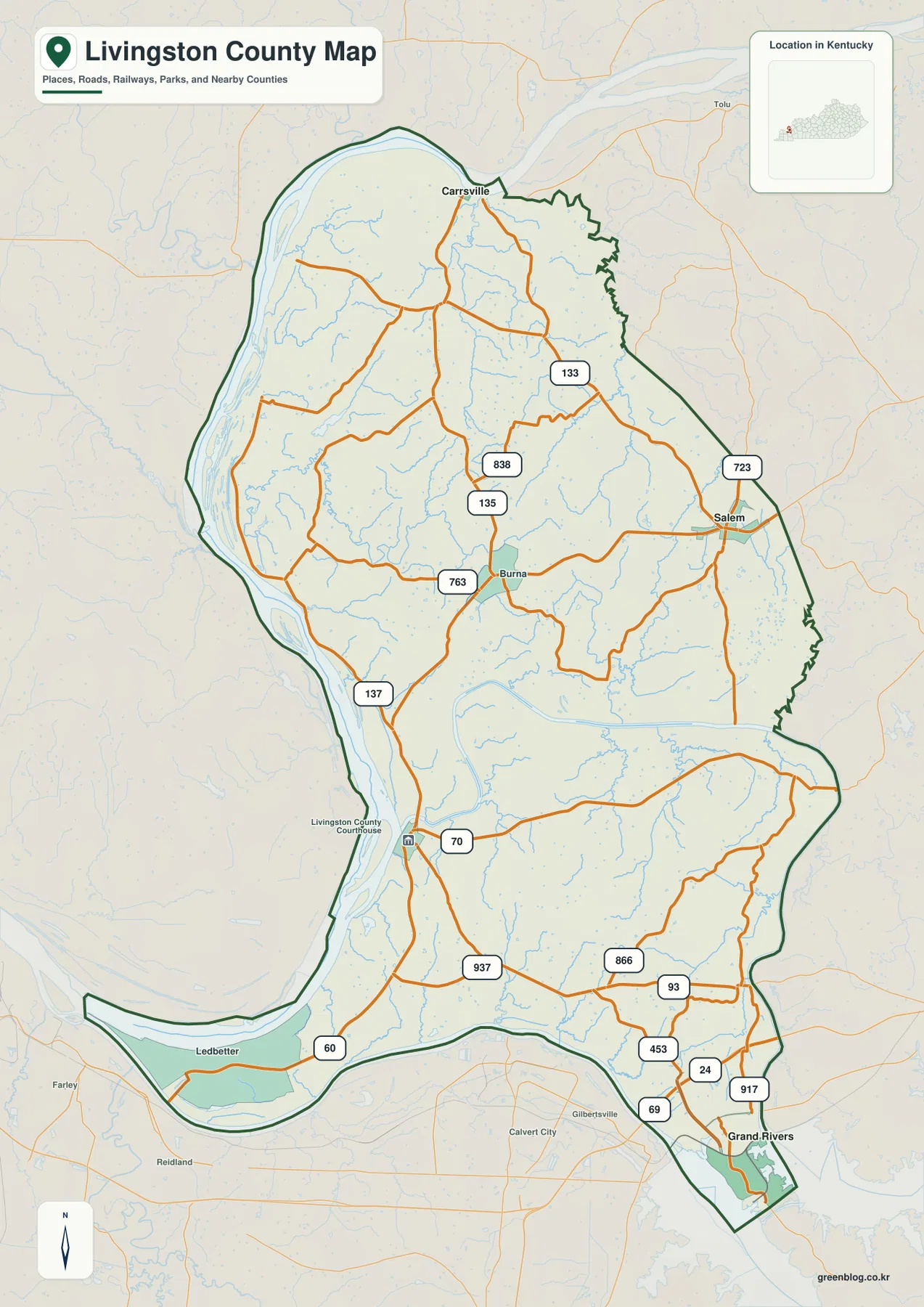
The general county map gives the clearest first view of Livingston County’s long, irregular shape. The Ohio River follows the western edge for a considerable distance, while the southern and southeastern boundary bends around broad water and narrow pieces of land. From Carrsville in the north to Grand Rivers in the southeast, the county narrows, widens, and changes direction several times. Those bends make much more sense when the boundary is viewed beside the river system instead of as an isolated administrative line.
Roads connect the county’s separated settlement areas by following this uneven terrain. Salem is associated with routes 723 and 133, while routes 135, 763, and 838 appear around Burna and the central interior. Route 137 and U.S. 60 are visible closer to the western side, and the southeastern end around Grand Rivers contains a dense cluster of route numbers including 93, 453, 24, 69, and 917. Rather than treating every number as equally important, it is easier to begin with Salem, Smithland, Carrsville, or Grand Rivers and then trace the roads that lead away from those reference points.
A Livingston County Courthouse marker appears near Smithland, giving the western river area an additional administrative reference. Salem, by contrast, is an inland road center on the eastern half of the county. Carrsville identifies the northern end, Grand Rivers helps define the southeastern extension, and Burna provides a useful midpoint between the larger reference places. Together these labels make it possible to read the county from several directions instead of assuming that one central town explains the whole map.
Neighboring county names also help with orientation. Crittenden County lies to the east of the northern section, Lyon County is farther southeast, and Marshall and McCracken counties appear across parts of the western and southwestern side. These outside labels show how Livingston County fits into the wider western Kentucky river-and-lake region. The map is intended for geographic reference, however, not for live traffic guidance, so current closures, construction, and turn-by-turn travel should be checked with up-to-date transportation sources.
Using Salem to compare the county’s main settlement areas
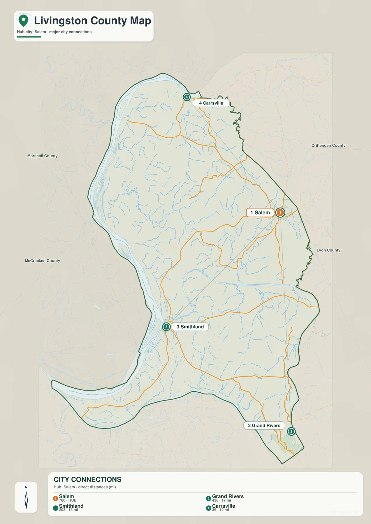
The city-connections map removes many of the smaller road labels and emphasizes the relative positions of Salem, Smithland, Grand Rivers, and Carrsville. Salem is shown as the hub point. Smithland lies to the southwest near the major rivers, Carrsville is north of Salem, and Grand Rivers sits far to the southeast. Because these places occupy different parts of the county rather than forming one compact cluster, the simplified map is especially useful for understanding the county’s overall length and direction.
The physical setting of each place is noticeably different. Smithland is tied closely to the broad river lowlands, while Salem is surrounded by the inland hill-and-creek landscape. Carrsville sits near the Ohio River along the northern end of the county. Grand Rivers is positioned near extensive water at the southeastern tip. Those contrasts matter because straight-line proximity on a simple city diagram does not describe the same travel conditions, terrain, or water barriers that appear on the more detailed maps.
The hub label on Salem should not be confused with the location of county government. The general map marks the Livingston County Courthouse near Smithland. The city map is designed to simplify settlement relationships, while the county map carries more road, boundary, and administrative information. Using the two together prevents a common mistake: assuming that the most visually central city on a diagram must also contain every county institution.
Grand Rivers is important because it keeps the long southern extension from disappearing from the mental picture of the county. A map focused only on Salem and Smithland would make Livingston County seem much more compact than it is. Carrsville serves a similar purpose in the north. When Carrsville, Salem, Smithland, and Grand Rivers are considered together, the county reads as a long chain of settlement areas linked through hills, river corridors, and narrow pieces of land.
Ohio River, Cumberland River, and the interior creek network
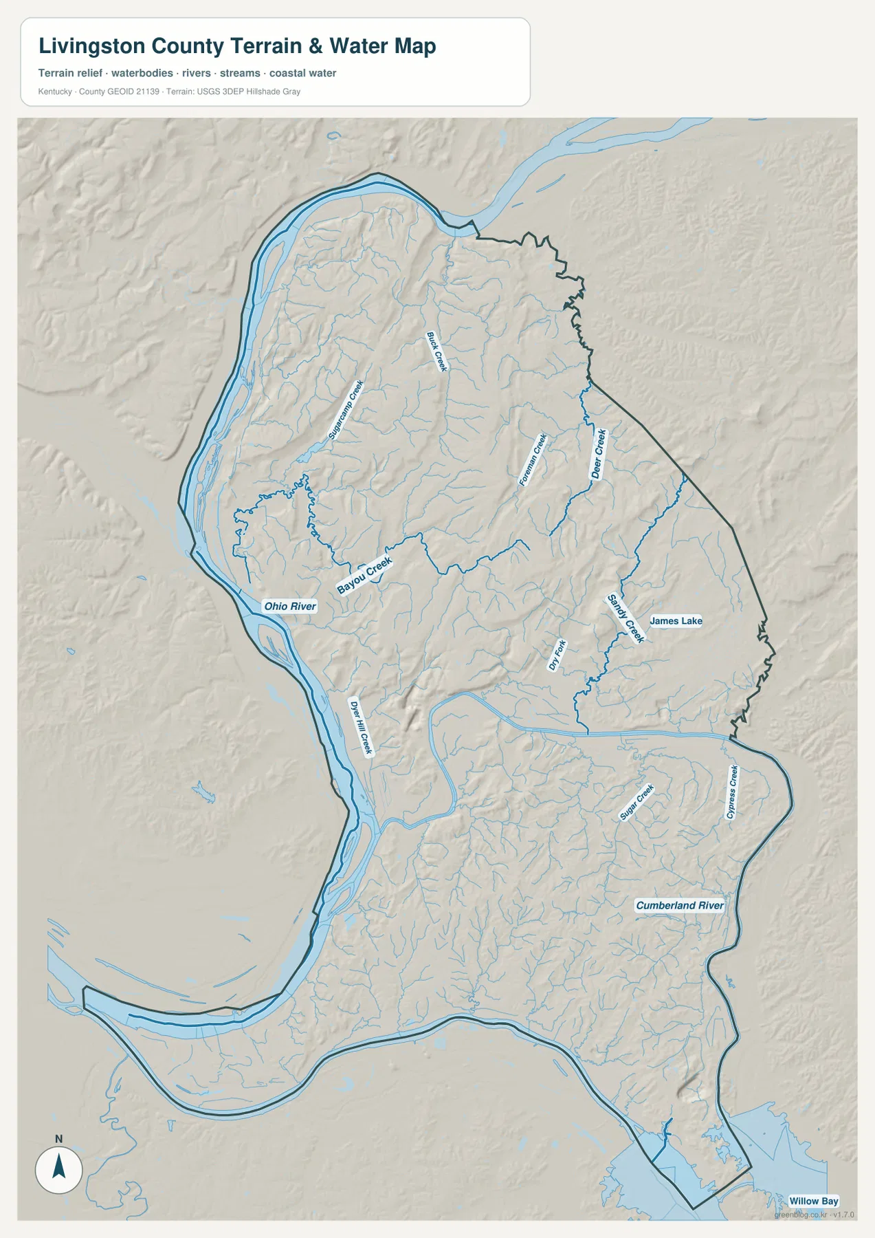
The terrain-and-water map shows how completely water organizes Livingston County. The Ohio River forms the dominant western corridor, and the Cumberland River enters from the east before crossing the southern half of the county toward Smithland. Between those large rivers is a dense network of smaller streams occupying narrow valleys in the hills. Starting with the two major rivers and then moving inward toward the tributaries is the easiest way to read the map without becoming lost in the many blue lines.
Several named creeks provide regional anchors. Sugarcamp Creek and Buck Creek appear in the north, while Foreman Creek and Deer Creek drain parts of the eastern interior. Bayou Creek runs through the central-western area toward the Ohio River. Sandy Creek and James Lake create recognizable water references east and south of Salem, and Sugar Creek and Cypress Creek appear farther south. Smaller tributaries branch between these named streams, revealing how finely the uplands are divided by creek valleys.
The Smithland area becomes especially understandable on this map because the wide Ohio and Cumberland river corridors draw close together there. If the courthouse marker is first located on the road map, the water map explains the physical setting around it. Salem is more clearly an inland place, surrounded by smaller drainages rather than a single broad river. Carrsville is closely associated with the Ohio in the north, while Grand Rivers sits at the county’s water-rich southeastern end.
Comparing streams with roads also helps explain why many routes curve rather than following a rigid grid. Roads often use lower valleys or work around steep, dissected terrain, and the largest rivers limit the number of places where direct crossings are practical. This map does not show current flood conditions, navigational clearance, water depth, boating rules, fishing regulations, or private access. Those questions require current information from the agencies responsible for transportation, water management, or recreation.
Higher northern ridges above the river lowlands
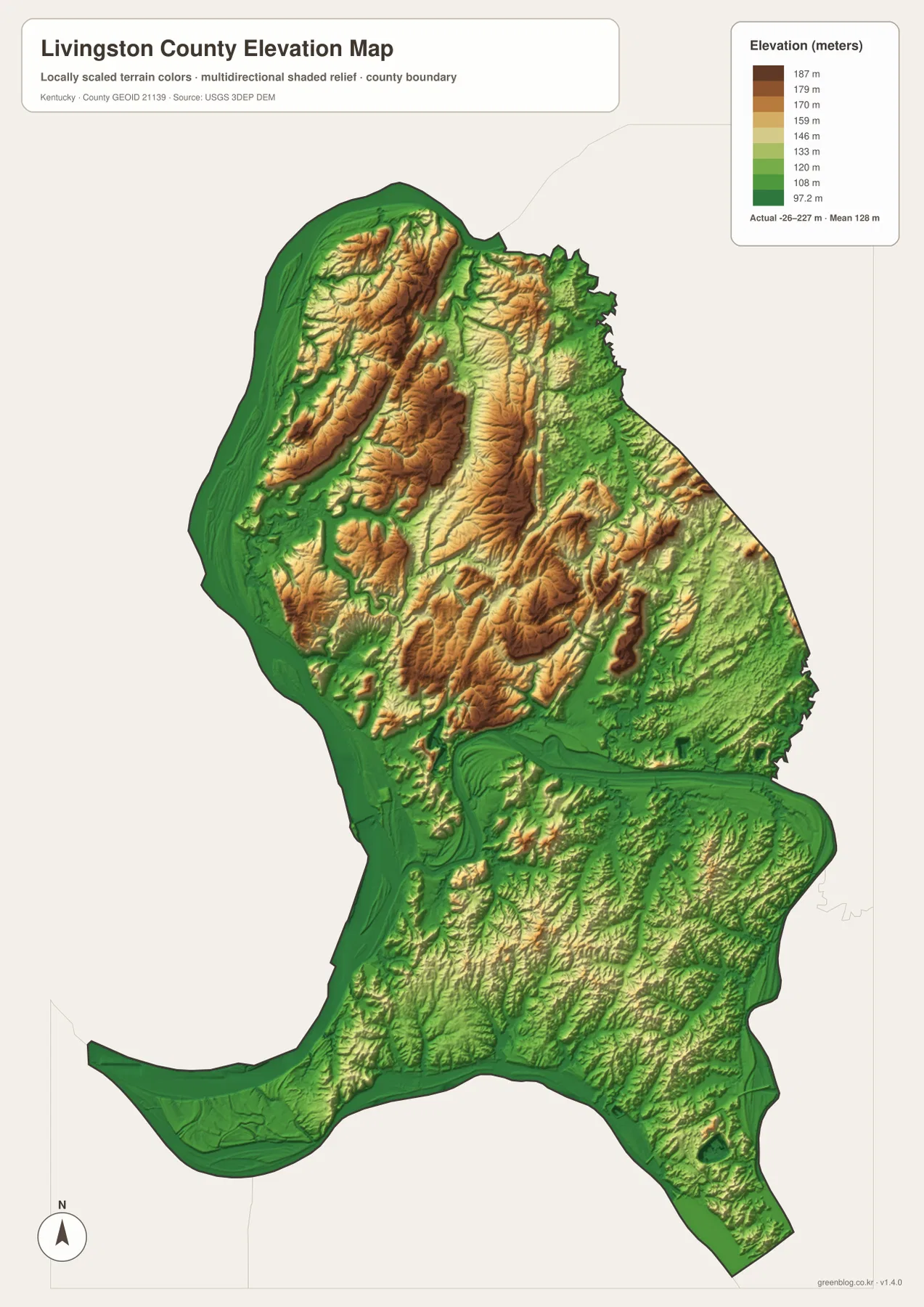
The elevation map makes the contrast between the interior hills and river margins immediately visible. Its main color legend spans roughly 97 to 187 meters, and the map notes a mean elevation near 128 meters. Brown and orange ridges are most prominent across the northern and north-central interior. Lower green terrain spreads along the Ohio River and follows the Cumberland River corridor. The sharp proximity of those colors shows that relatively high ridges can stand only a short distance from broad, low river bottoms.
The northern uplands are not one flat block. Green valleys penetrate the higher colors in many places, separating long narrow ridges. Those low corridors closely match the smaller streams shown on the terrain-and-water map. When the two maps are compared, the relationship is straightforward: tributaries occupy the lower cuts while ridges rise between them. That pattern also provides useful context for the winding roads visible on the general county map.
Salem occupies an inland setting where hills and valleys alternate, while the Smithland side becomes lower as it approaches the large rivers. Carrsville likewise sits close to the Ohio River with higher terrain immediately inland. The southeastern Grand Rivers area is dominated by water and lower ground, creating a strong visual contrast with the brown ridges farther north. The county therefore cannot be summarized as simply high in one direction and low in another; its elevation changes repeatedly according to river corridors and creek valleys.
This elevation surface is intended for county-scale comparison rather than site-level measurement. The colors help distinguish ridges, valleys, and broad lowlands, but they do not provide survey-grade elevation for a parcel, road, building site, or stream crossing. Construction, engineering, drainage design, and legal surveying should use current source elevation data or field measurements. For classroom, presentation, and general geographic use, the map clearly communicates the relationship between the county’s hills and major waterways.
Following one place across the different maps
Salem is the easiest starting point for moving from one map to another. On the county map it sits near routes 723 and 133, on the city map it becomes the hub for comparing the other highlighted settlements, and on the water map it is surrounded by smaller inland drainages rather than a broad river. The elevation view adds the final piece by showing alternating uplands and lower creek corridors. Following the same place through each map makes their different purposes clear without treating them as four unrelated graphics.
Smithland offers a second useful comparison. The general map provides the courthouse and road context, while the water map shows the major Ohio and Cumberland river corridors beside the settlement. The elevation map then makes the low river setting visible through broad green tones. This combination is particularly effective when explaining why Smithland has a different geographic character from Salem even though both are important county reference points.
Grand Rivers adds the county’s southeastern perspective. The city map makes its separation from Salem obvious, the road map shows several routes converging toward the tip of the county, and the physical maps emphasize the large amount of surrounding water and low ground. Without Grand Rivers, the county’s long southern reach is easy to underestimate. Including it in a map lesson or presentation gives a much more complete picture of Livingston County’s shape.
Carrsville does the same for the north. It lies near the Ohio River at the upper end of the county, with ridges and small drainages extending southward from the area. Comparing Carrsville with Grand Rivers gives the clearest sense of Livingston County’s north-to-southeast length. It also shows why a single central reference point is not enough for a county whose boundary is so strongly influenced by rivers and narrow extensions of land.
Choosing the map that best matches the question
Use the general county map when you need roads, named settlements, neighboring counties, administrative markers, and the overall boundary in one view. It is the strongest choice for locating Salem, Burna, Carrsville, Smithland, and Grand Rivers and for tracing numbered routes between them. The city-connections map is better when the goal is a simpler presentation of how the four highlighted settlement areas relate to one another across the long county shape.
Choose the terrain-and-water map for the Ohio River, Cumberland River, named creeks, James Lake, and the valleys that separate the hills. It contains less road detail but far more physical context. Choose the elevation map when the question is about relief rather than individual stream names. Its color scale makes the northern ridges and major river lowlands easy to compare, especially when used beside the water map.
The WebP images in the article are optimized for on-screen viewing. The downloadable archive contains the original JPG maps at 2,572×3,638 pixels each, which is more suitable for printing, classroom worksheets, presentation slides, and offline reference. These maps are explanatory graphics rather than legal boundary records, flood studies, navigation products, parcel surveys, or engineering plans. The authoritative links in the reference section are the better starting point when a project requires current underlying data.
Frequently Asked Questions
Should I use Salem or Smithland as the main reference point?
Use Salem when you want an inland reference for comparing the county’s main settlement areas and road directions. Use Smithland when the courthouse, Ohio River, Cumberland River, and western river lowlands are more important to the question. Starting at Salem for orientation and then moving to Smithland for river context is an easy way to understand the county without treating one place as the answer to every map question.
Which map best shows the Ohio and Cumberland rivers together?
The terrain-and-water map is the clearest choice. It shows the Ohio River along the western side and the Cumberland River crossing the southern half of the county toward Smithland. Named creeks and shaded relief add context, making it easier to see how the major rivers relate to the smaller valleys and interior hills.
Can the elevation colors be used as exact property elevations?
No. The elevation map is designed for county-scale comparison. It is useful for distinguishing the higher northern ridges from lower river corridors, but it does not provide survey-grade elevations for a parcel, building site, road, or stream crossing. Exact site work should rely on current source elevation data or professional field measurements.
Map File Information
The ZIP archive contains the original high-resolution JPG versions of the Livingston County road-and-boundary map, city-connections map, terrain-and-water map, and elevation map. Each image is 2,572×3,638 pixels for printing, classroom work, presentations, and offline reference.
- File Type: 4 JPG files inside one ZIP archive
Related Maps
Sources and references
County government and local background are available through the official Livingston County government website and its Livingston County tourism page. For underlying geographic data, consult the U.S. Census Bureau TIGER/Line Shapefiles for boundaries and transportation features, USGS National Hydrography for water features, and the USGS 3D Elevation Program for elevation data.
These maps are intended for geographic explanation, printing, and general reference. Legal boundary decisions, flood and water-safety decisions, live roadway conditions, navigation, engineering design, and field surveying should rely on the latest authoritative information from the responsible agency.
Green Map creates custom-edited map images using open geographic data sources such as geoBoundaries, Natural Earth, OpenStreetMap, and government open data. These maps are edited visual materials, not raw data files, and are provided for education, documents, presentations, and graphic reference.