Daviess County occupies a broad stretch of western Kentucky where Owensboro sits beside the Ohio River and the land becomes more rolling toward the east. Owensboro is the dominant urban reference point near the northern riverfront, while Whitesville is the second major city marked farther east. U.S. 60 and U.S. 231 provide the clearest route anchors, with KY 54, 56, 81, 144, and other state highways connecting smaller communities across the county. High-resolution map files are available for download in the section below.
This page combines maps for county boundaries and roads, major-city location, waterways and terrain, and elevation. High-resolution JPG originals for all four maps can be downloaded together in one ZIP, which is useful when the smaller WebP display images do not show route numbers or creek labels clearly enough. These are county-scale reference maps rather than live navigation, flood, parcel, legal-boundary, or survey products.
Table of Contents
Owensboro anchors the road network along a sweeping Ohio River boundary
The general county map places Owensboro near the center of the northern half, immediately south of the Ohio River. U.S. 60 crosses the urban area and continues eastward, while U.S. 231 runs south through the county. KY 144 leaves the Owensboro area toward Philpot, and KY 54 continues toward Whitesville. To the west and southwest, KY 56, KY 279, and KY 81 create additional links, giving Owensboro a distinctly radial road pattern when the county is viewed as a whole.
Sorgho appears just west of Owensboro, with Stanley farther west and northwest. South of the city, Moseleyville, Panther, Masonville, and Utica provide useful local reference points along the road network. Philpot lies east of Owensboro, Whitesville is farther toward the eastern edge, and Maceo and Yelvington sit to the northeast. The result is not a county with several equally prominent urban centers; instead, one large river city is surrounded by smaller places distributed along multiple highway corridors.
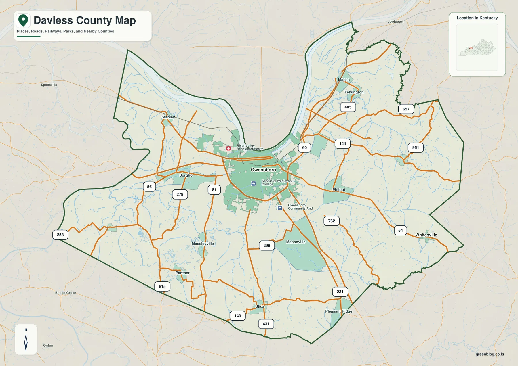
The Ohio River forms a long, curved northern boundary rather than a straight county line. Its broad bends are especially visible north and northeast of Owensboro, where the county outline follows the river. Low ground extends inland from much of the riverfront, and the built-up Owensboro area occupies part of that lower northern setting. Farther east, the road network crosses increasingly uneven terrain marked by short ridges and narrow stream valleys.
Route numbers are most helpful when the map is used for regional orientation. U.S. 60 ties Owensboro to the Maceo and Yelvington side of the county, U.S. 231 runs toward the southern boundary, KY 54 reaches Whitesville, and KY 144 connects eastern communities closer to Owensboro. Smaller numbered roads such as KY 657, KY 762, and KY 951 fill in the eastern network. Current closures and construction should always be checked separately, but the static map is effective for understanding how the county is connected.
The city map reduces the county to Owensboro and Whitesville
The major-city map strips away most local labels and highlights only Owensboro and Whitesville. Its CITY INDEX ranks Owensboro first and Whitesville second, with values of 60,302 and 661 shown in the supplied image. Because the map does not identify the statistical year or definition for those numbers, they are best treated only as values displayed by the map rather than as a claim about a specific current census estimate.
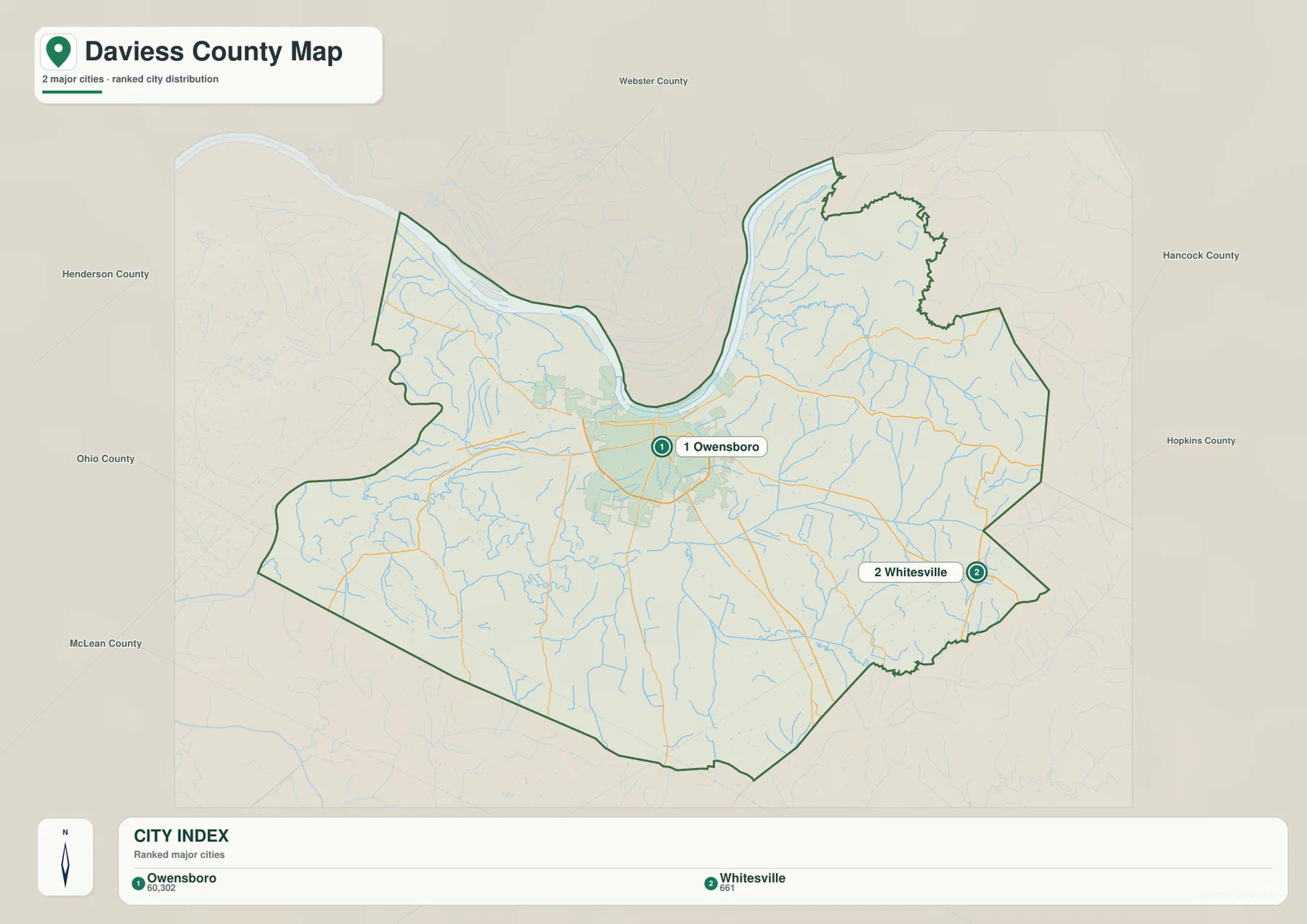
That simplified view makes the separation between the two cities easy to see. Owensboro occupies the north-central river side, whereas Whitesville is positioned near the eastern edge. Neighboring Henderson County appears to the northwest, Webster County to the north, Hancock County to the northeast, Hopkins County to the east, Ohio County to the west, and McLean County to the southwest. For a presentation or quick locator graphic, this map communicates the county’s regional position more cleanly than the denser road map.
Owensboro also serves as the county’s administrative hub. The official Daviess County government page lists Fiscal Court administration at the Daviess County Courthouse in Owensboro. That local-government role fits the map pattern: the county’s largest urban area, riverfront setting, and strongest concentration of roads all coincide around Owensboro rather than being divided among several separate centers.
Ohio River lowlands meet the Green River and Panther Creek systems
The terrain-and-water map is dominated by the Ohio River along the north. The river sweeps around a large bend above Owensboro, and broad low terrain follows much of that northern edge. The west and northwest are comparatively open and low, while the eastern and southeastern interior shows a denser pattern of small valleys. Shaded relief makes the contrast between river lowland and rolling inland terrain visible without relying only on contour numbers.
In the southwest, the Green River is labeled near Panther Creek and Flat Lick Creek. Old Panther Creek and Horse Creek continue farther east, while North Fork Panther Creek and South Fork Panther Creek extend across the central and eastern county. Seeing those related watercourses together makes the southern half easier to understand: the county is crossed by several branching drainage corridors rather than by one single interior river.
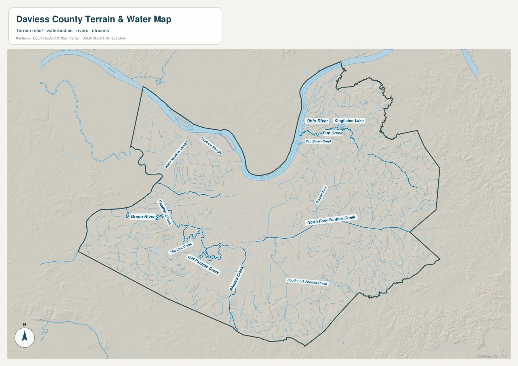
Burnett Fork is one of the stronger named streams in the northeast. Close to the Ohio River, Pup Creek and Van Buren Creek are labeled, and Kingfisher Lake appears nearby. The northwest also includes Cowhide Slough and Little Hurricane Slough. Those names show that the northern river environment is more complex than a single channel, with small tributaries, sloughs, and low wet areas extending back from the main river.
The official Daviess County history page notes that the county was created from part of Ohio County in 1815 and that its boundaries changed several times afterward. On the modern map, the Ohio River is the strongest natural edge, while the interior creek network explains much of the local relief. This water map should not be used as a flood-risk map, depth chart, navigation aid, or statement of public access; current conditions and regulations require information from the responsible agencies.
A 108–205 meter range separates broad river lowlands from eastern ridges
The elevation map reports an actual range of about 108 to 205 meters, with a mean near 129 meters. Green represents the lower parts of the county, and yellow to brown marks higher terrain. The broadest low areas lie along the Ohio River, around Owensboro, and across much of the western county. Those connected green zones make the northern riverfront and west side look distinctly flatter than the east.
Elevation rises toward the eastern and southeastern interior. Around and beyond Whitesville, short ridges become much more closely packed, and small valleys cut between them. The northeast also contains several higher ridge groups east of the Maceo and Yelvington area. Compared with the broad Owensboro lowland, the terrain there is visibly more dissected even though the county’s absolute elevations remain moderate.
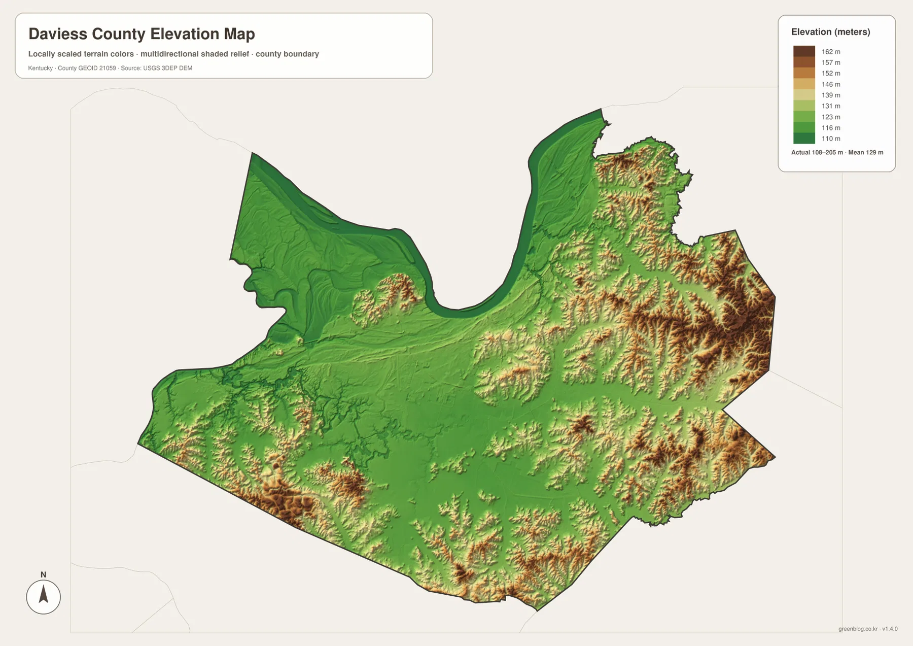
The southwest is not uniformly flat. Lower corridors associated with the Green River and Panther Creek are interrupted by small hills, and higher patches appear again near parts of the southern boundary. A better description of Daviess County is therefore a combination of broad river lowland, gently rolling central ground, and more strongly ridged terrain toward the east rather than a single flat surface.
The difference between the lowest and highest mapped values is about 97 meters. That is modest compared with mountain counties in eastern Kentucky, but it is enough to change the local shape of roads and streams. Owensboro and the Ohio River occupy broad lower ground, while eastern routes pass through a closer alternation of valley floors and ridge tops.
These elevation colors are intended for county-scale comparison. They do not give survey-grade elevation for a house, bridge, parcel corner, or construction site, and they should not be used for drainage design or hazard decisions. Detailed work should rely on USGS 3D Elevation Program data, engineering records, or professional surveying.
Pick the map by whether you need routes, waterways, or terrain
The general county map is the best choice when the goal is to trace roads between Owensboro, Whitesville, Utica, Stanley, Philpot, and other labeled places. It combines U.S. 60 and 231 with state routes such as KY 54, 56, 81, and 144, so local names and travel direction can be read together. The city map is cleaner when only Owensboro, Whitesville, and neighboring counties need to be shown.
For natural features, the terrain-and-water map provides the strongest context because it labels the Ohio River, Green River, Panther Creek branches, Burnett Fork, Horse Creek, and smaller water bodies while retaining shaded relief. The elevation map simplifies that information into a height comparison, making the 108–205 meter range and the eastward increase in ridge relief easier to see quickly.
The original files are 3638 × 2572 pixel JPG images. The WebP versions in the article are optimized for on-page viewing, so the downloadable originals are more convenient when route shields, creek labels, and elevation colors need to be enlarged or printed. They can support personal reference, classroom use, presentations, and regional orientation, while legal, emergency, engineering, and live travel decisions should use current authoritative sources.
Frequently Asked Questions
Which map gives the clearest comparison between Owensboro and Whitesville?
The city map is the simplest choice because it highlights only the two major cities and neighboring counties. Owensboro appears near the Ohio River in the north-central county, while Whitesville is much farther east. Use the general county map when you also need U.S. 60, U.S. 231, KY 54, KY 144, or smaller local place names.
Where is the lowest terrain in Daviess County?
The elevation map shows the broad Ohio River and Owensboro side, along with much of the western county, as the lowest terrain. The mapped range is about 108 to 205 meters with a mean near 129 meters, and higher ridge clusters become much more common toward the east and southeast.
What is included in the downloadable ZIP?
The ZIP contains high-resolution JPG originals for the county map, city map, terrain-and-water map, and elevation map. Each file is 3638 × 2572 pixels, making the originals more suitable for print and close label inspection than the smaller WebP images displayed on the page.
Map File Information
The four Daviess County maps used on this page are available as high-resolution JPG originals in one ZIP. The larger files are better suited to printing and close inspection of road numbers, waterway names, and elevation colors than the WebP display images.
- Included Files: county map, city map, terrain and water map, elevation map
- File Type: JPG
Related Maps
Sources and references
Local government and background information are available from the Daviess County Fiscal Court and the official Daviess County history page. Administrative boundary data are available from U.S. Census Bureau TIGER/Line Shapefiles, hydrography from USGS National Hydrography, and terrain data from the USGS 3D Elevation Program. Use current agency information for road conditions, water levels, hazards, access, and legal boundaries.
Green Map creates custom-edited map images using open geographic data sources such as geoBoundaries, Natural Earth, OpenStreetMap, and government open data. These maps are edited visual materials, not raw data files, and are provided for education, documents, presentations, and graphic reference.