Carroll County occupies a compact stretch of northern Kentucky where the Ohio River defines the long northern edge and the Kentucky River reaches it at Carrollton. That meeting of two major rivers gives the county an unusually clear geographic center. Carrollton and neighboring Prestonville sit near the confluence, Ghent follows the Ohio River to the northeast, Sanders marks the narrow eastern end, and Worthville lies farther south in the interior. Interstate 71 crosses the county diagonally, tying the river communities to a network of state highways that reach the hillier inland areas. High-resolution map files are available for download in the section below.
This page provides four complementary Carroll County maps for viewing on screen, and the original high-resolution JPG files can be downloaded together in a ZIP archive for printing or closer inspection. The general map is best for roads and county orientation, while the city map simplifies the settlement pattern. The water map emphasizes the Ohio and Kentucky Rivers and their tributaries, and the elevation map shows an actual range of about 129 to 283 meters. These maps are intended for general geographic reference rather than parcel boundaries, flood determinations, surveying, engineering, or live navigation.
Table of Contents
Carrollton, the river confluence, and I-71 define the county’s center
Carrollton is the easiest place to begin reading the county. It sits near the north-central edge, where the Kentucky River reaches the Ohio River, and several important routes converge nearby. I-71 approaches from the southwest, passes just south of Carrollton, and continues northeast toward the Ghent side of the county. Because river-oriented roads and the interstate come close together here, Carrollton serves as a practical reference point for understanding both the waterfront and the interior road network.
KY 42 follows much of the western Ohio River side, while KY 55 links the southwest interior with the I-71 corridor. Routes 227, 389, and 467 serve the southern half of the county, and KY 550 appears inland from Ghent. At Sanders, KY 36 and KY 47 form the clearest road reference near the eastern tip. The pattern is not a simple grid: roads bend with valleys and river margins, and several routes feed toward I-71 rather than running in long parallel lines. That makes the highway labels useful when distinguishing the river communities from the more rural interior.
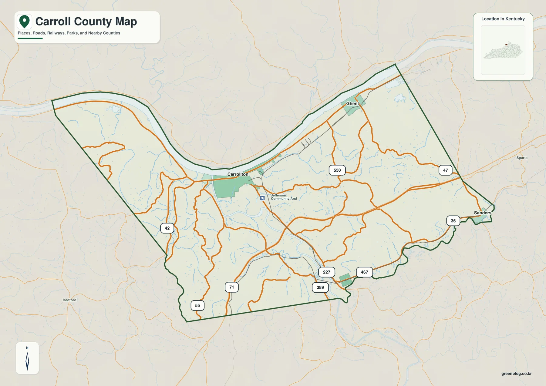
The county outline also tells part of the story. Its northern boundary bends with the Ohio River rather than following a straight line. The western end curves deeply around a river bend, the middle narrows near Carrollton, and the county broadens again toward Ghent before tapering to the Sanders area in the east. The southern boundary is more land-based and comparatively direct. Once this outline is familiar, it becomes easier to understand why several communities cluster along the northern edge while other roads fan southward into ridges and creek valleys.
Carroll County’s official government site describes the county as the place where the Ohio and Kentucky Rivers meet and highlights its position on I-71 between Louisville and Cincinnati. The county was established in 1838, with Carrollton as the county seat. Those facts are visible in the modern map rather than being merely historical notes: the county seat occupies the river junction, a major interstate passes close by, and much of the settlement and road pattern is organized around access to that central northern corridor.
Five mapped communities spread from the Ohio River to the southern interior
The city map highlights five communities: Carrollton, Sanders, Ghent, Prestonville, and Worthville. Carrollton is the dominant north-central reference, while Prestonville sits immediately to its west and reads almost as a neighboring river-area community at this scale. Ghent lies farther northeast along the Ohio River. Sanders occupies the far eastern extension of the county, and Worthville provides a southern interior point that balances the concentration of places along the northern edge.
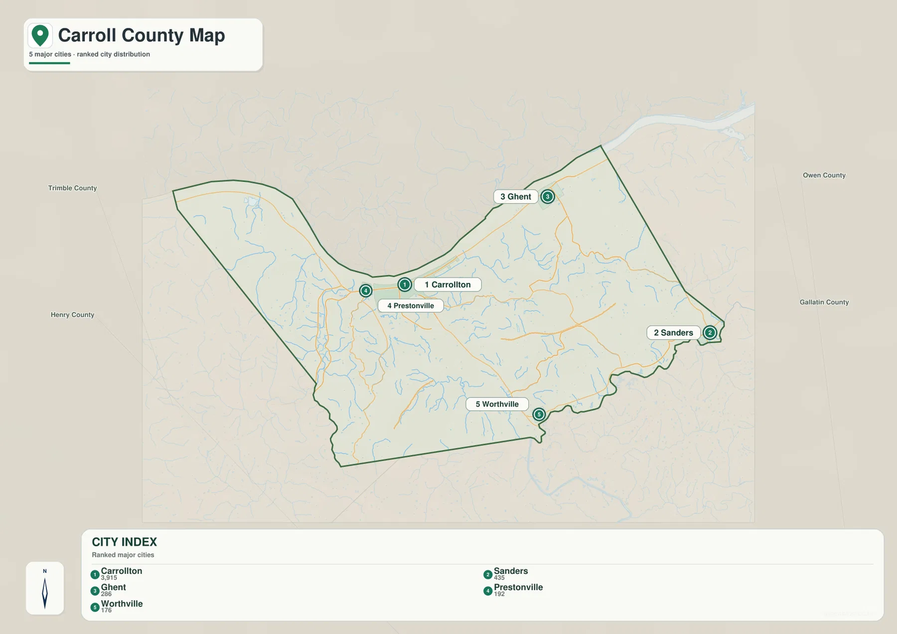
These locations align with the road network in useful ways. Carrollton and Ghent are connected to the broader I-71 corridor, although the settlements themselves remain close to the river side. Sanders is easy to locate where KY 36 and KY 47 meet near the eastern edge. Worthville lies in the southern part of the county around KY 467, away from the main Ohio River strip. Prestonville is so close to Carrollton that it is most useful as a local reference within the confluence area rather than as a separate end point for county-wide orientation.
The city map intentionally removes much of the road and terrain detail. That makes it a good choice for presentations, classroom work, or a quick location graphic when the names of the communities matter more than the route numbers. When the question changes to how those places connect, the general map should be used alongside it. The contrast is especially useful for Sanders and Worthville, which are easy to place on the city map but need the road layer to show how they link back toward Carrollton.
The Ohio and Kentucky Rivers organize a network of smaller valleys
The water map is dominated by two large rivers. The Ohio River forms the northern edge, while the Kentucky River enters from the south and bends northward to meet it at Carrollton. Their confluence creates the broadest lowland in the middle of the county’s northern side. West of that junction, the Little Kentucky River drains toward the Ohio through the western part of the county. Smaller channels such as West Prong Locust Creek and Carlisle Branch occupy nearby valleys and add detail to the western drainage pattern.
East of the Kentucky River, Fourmile Creek reaches toward the Ohio River, while Stevens Branch and Stony Creek mark smaller drainage lines farther east. Goose Creek is prominent in the southeast, and Mill Creek and Lees Creek occupy valleys closer to the lower Kentucky River corridor. These tributaries are short compared with the Ohio and Kentucky Rivers, but they explain much of the texture seen in the terrain. Their courses curve through low gaps between ridges rather than crossing the uplands in straight lines.
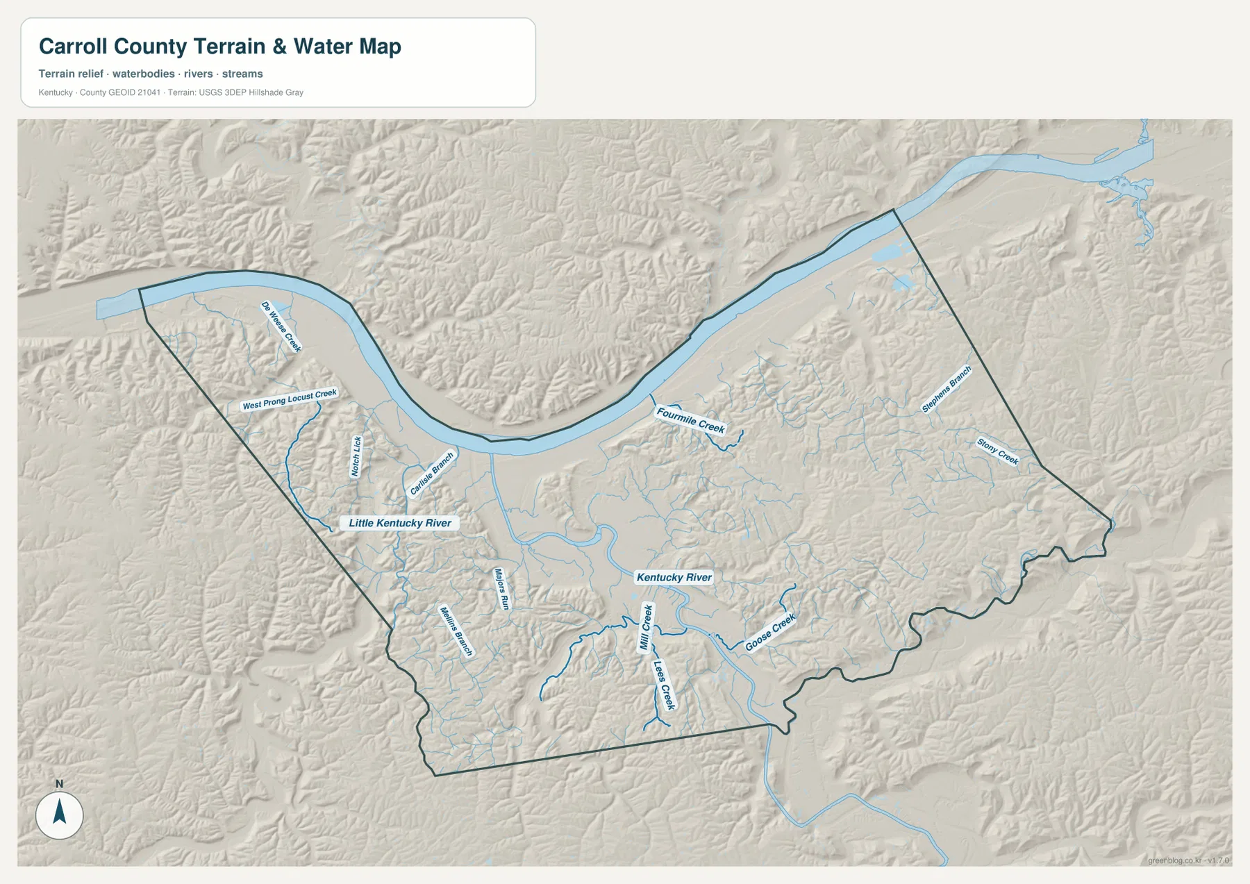
The difference between the river margins and the interior is visible in the shape of the drainage. Broad, relatively open lowlands lie beside the Ohio River and along the lower Kentucky River. Away from those corridors, the tributaries become more branched and occupy narrower valleys cut into the hills. The Little Kentucky River provides a western counterpart to the Kentucky River valley, while Fourmile Creek and Goose Creek help orient the eastern half. Reading those waterways together makes the county’s relief easier to understand even before looking at the elevation colors.
This map should not be used as a current flood, water-level, water-quality, navigation, or public-access map. Conditions along the Ohio and Kentucky Rivers can change, and a mapped stream does not establish the status of a crossing or shoreline. For property or safety decisions, use current flood and local agency information. Here, the purpose is to identify named rivers and creeks, compare their relative locations, and understand how they fit within the county landscape.
A 129–283 m elevation range reveals low river corridors and higher ridges
The elevation map shows an actual range of roughly 129 to 283 meters, with a mean near 199 meters. The lowest terrain forms a long green band beside the Ohio River and extends inland along the Kentucky River valley. Carrollton and the confluence sit within this lower zone. Moving away from the large rivers, colors shift toward tan and brown as the land rises into rolling and locally steep ridges. The absolute elevations are modest, but the county-wide contrast between low valleys and higher interior ground is strong.
On the western side, short ridges rise quickly south of the Ohio River bend, and the southwest contains another concentration of higher ground. The eastern half has broad belts of rolling upland, including higher terrain toward the Sanders extension. Between those ridges, narrow green corridors follow Fourmile Creek, Goose Creek, Mill Creek, and other tributaries. Comparing the water and elevation maps makes the relationship clear: the named streams generally occupy the lower routes through a more dissected interior landscape.
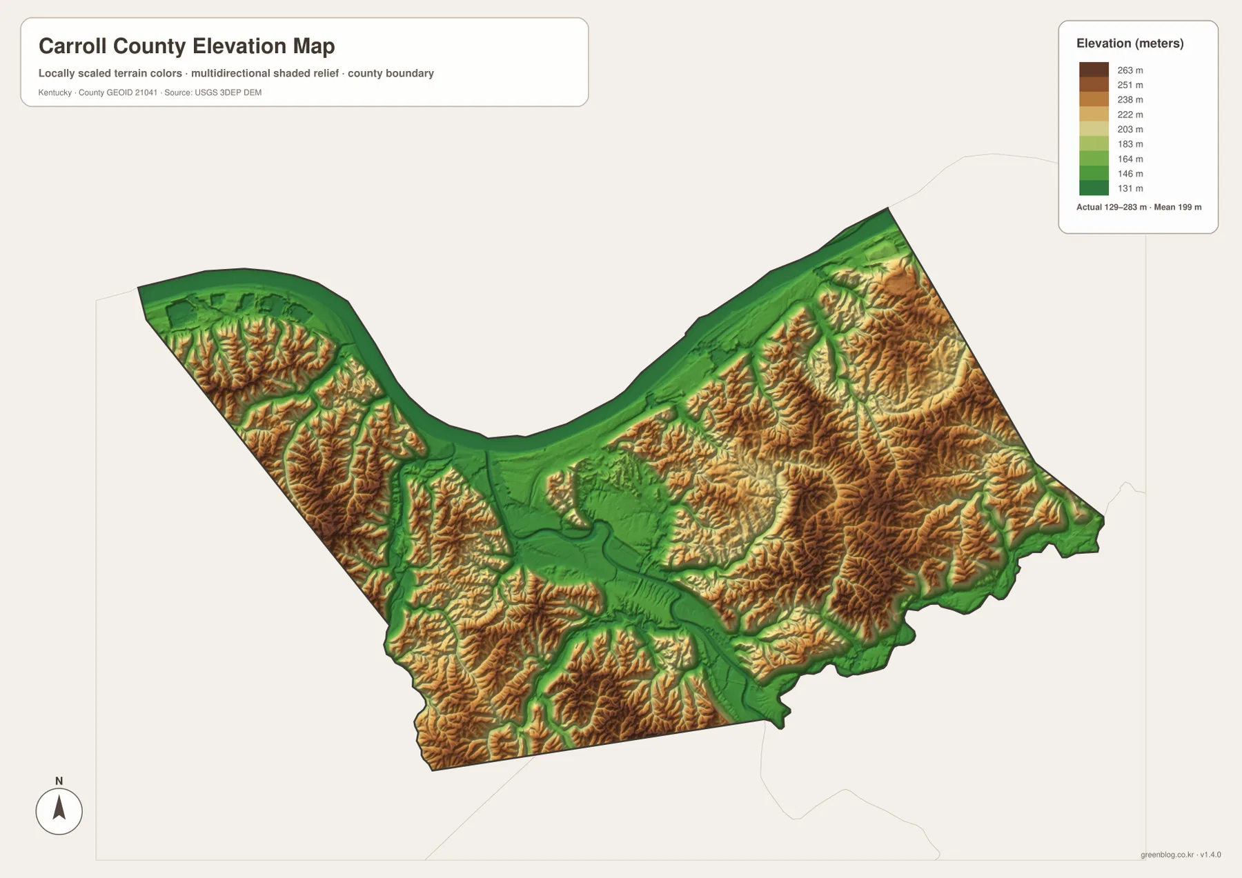
Carroll County is not a mountain county, yet the map demonstrates why it should not be described as uniformly flat. The rivers have broad low corridors, while the land between tributaries rises and falls repeatedly. Some road segments that look simple on the general map cross a landscape of small ridges and valleys. I-71 also passes through changing relief rather than a single flat strip. That terrain helps explain why the county contains so many short creeks even though its overall area is compact.
The elevation colors are generalized for county-scale comparison and are not survey-grade measurements. They are useful for seeing that the river margins are low and the interior ridges are higher, but they should not be used to determine the exact elevation of a building site, road grade, drainage project, or property corner. Detailed engineering work requires source data such as the USGS 3D Elevation Program and, when necessary, professional field surveying.
Match the map to the task: routes, settlements, water, or relief
The general map is the most useful single choice when you need several kinds of information together. It places Carrollton, Ghent, and Sanders beside I-71 and state routes while retaining the river-shaped county outline. The city map is cleaner when the goal is simply to compare Carrollton, Prestonville, Ghent, Sanders, and Worthville. Used together, the two maps let a reader learn the settlement pattern first and then add route numbers and boundary context without crowding a single graphic.
For river and creek questions, the water map carries the most detail. It shows the Ohio–Kentucky River confluence as well as the Little Kentucky River, Fourmile Creek, Goose Creek, Mill Creek, Lees Creek, and smaller tributaries. The elevation map answers a different question by separating low corridors from higher ridges. Its 129–283 m range makes the broad river bottoms easy to distinguish from the rolling interior, especially when the two physical-geography maps are viewed side by side.
For printed material, it is usually clearer to choose the map that matches the question rather than forcing every label into one image. A local orientation handout may pair the general and city maps. A lesson about the Carrollton confluence can begin with the water map and then use the elevation map to explain the surrounding valleys. A road-focused page can start with I-71 and the state routes and add the city map only where settlement names are needed. Each file covers the same county, but the visual emphasis is intentionally different.
Frequently Asked Questions
Which map best shows where the Ohio and Kentucky Rivers meet at Carrollton?
Use the water map when the river junction itself is the main subject. It makes the Ohio River boundary and the Kentucky River approach to Carrollton easy to trace. The general map is better when you also need I-71, nearby roads, and the relationship between Carrollton and other communities, so the two maps work especially well as a pair.
What is the simplest map for comparing Ghent, Sanders, Worthville, and Prestonville?
The city map removes most terrain and route detail and highlights the five mapped communities. Ghent is on the northeastern Ohio River side, Sanders is at the eastern end, Worthville is in the southern interior, and Prestonville sits beside Carrollton. Switch to the general map when you need I-71 or state routes such as KY 36, KY 47, and KY 467.
What does the 129–283 m elevation map show most clearly?
Its strongest contrast is between the low Ohio River margin and Kentucky River valley and the higher ridges across the western, southern, and eastern interior. The mean is about 199 meters, but the color pattern is meant for relative county-wide comparison. It should not be treated as the precise elevation of a property, road, or construction site.
Map File Information
Carroll County map files
- Included Files: county map, city map, water map, elevation map
- File Type: JPG
Related Maps
Sources and references
Local context for the two-river confluence, I-71, and Carroll County is available from the official Carroll County Fiscal Court website, while the Kentucky Historical Society’s Carrollton marker provides historical context for the county seat. Boundary data can be referenced through U.S. Census Bureau TIGER/Line, hydrography through USGS National Hydrography, and elevation through the USGS 3D Elevation Program.
Green Map creates custom-edited map images using open geographic data sources such as geoBoundaries, Natural Earth, OpenStreetMap, and government open data. These maps are edited visual materials, not raw data files, and are provided for education, documents, presentations, and graphic reference.