Bath County lies in northeastern Kentucky, with Owingsville serving as the county seat and the clearest road reference between Sharpsburg in the west and Salt Lick in the east. US 60 crosses the county through the central settlement belt, while KY 11, KY 36, KY 211, KY 826, and smaller state roads descend into narrow valleys and climb wooded ridges. The eastern extension reaches toward Cave Run Lake and the Daniel Boone National Forest, giving that side of the county a very different character from the higher western hills. High-resolution map files are available for download in the section below.
This guide follows Owingsville, Sharpsburg, Salt Lick, Flat Creek, Slate Creek, the Cave Run Lake side, and terrain ranging from about 180 to 416 meters. WebP previews are available for quick viewing, and the matching high-resolution JPG files can be downloaded together in one ZIP for printing, classroom work, or offline reference.
Table of Contents
Owingsville anchors the county road network and county government
Owingsville sits near the center of Bath County, with US 60 providing the most useful east–west reference. KY 36 extends south from the county-seat area, while local and state routes branch north and east into the surrounding ridge-and-creek country. From this central location, Sharpsburg, Salt Lick, and the southern drainage valleys can all be compared without relying on a single outer highway.
Bath County government identifies Owingsville as the county seat, and a Kentucky Historical Society marker records that Bath County was formed from Montgomery County in 1811. The community was named for Thomas D. Owings, an early regional businessman associated with the Bourbon Iron Works. County government remains concentrated in Owingsville today.
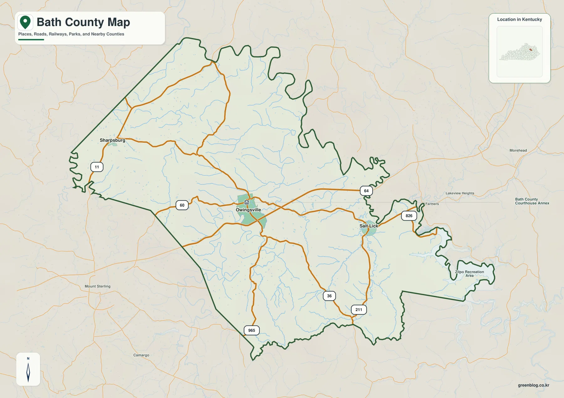
Sharpsburg lies in the western part of the county near KY 11, while Salt Lick occupies the eastern US 60 and KY 211 corridor. The narrow southeastern extension reaches Zilpo Recreation Area on Cave Run Lake. Mount Sterling west of the county and Morehead to the east provide useful regional references beyond the boundary.
The city-connections panel compares Owingsville with Sharpsburg and Salt Lick
The supplied city-connections panel places Owingsville at an index value of 1,621, Sharpsburg at 519, and Salt Lick at 274. These are map index values rather than current official population estimates. The panel also labels Sharpsburg at about 10 miles and Salt Lick at about 8 miles in straight-line distance from Owingsville; those values are not driving distances.
The two smaller towns sit within a similar distance band but occupy different terrain. Sharpsburg is tied to the more strongly dissected western hills and the Flat Creek system, while Salt Lick lies in a lower eastern corridor near Slate Creek, Salt Lick Creek, and routes toward Cave Run Lake. The contrast becomes much clearer when the city panel is compared with the water and elevation views.
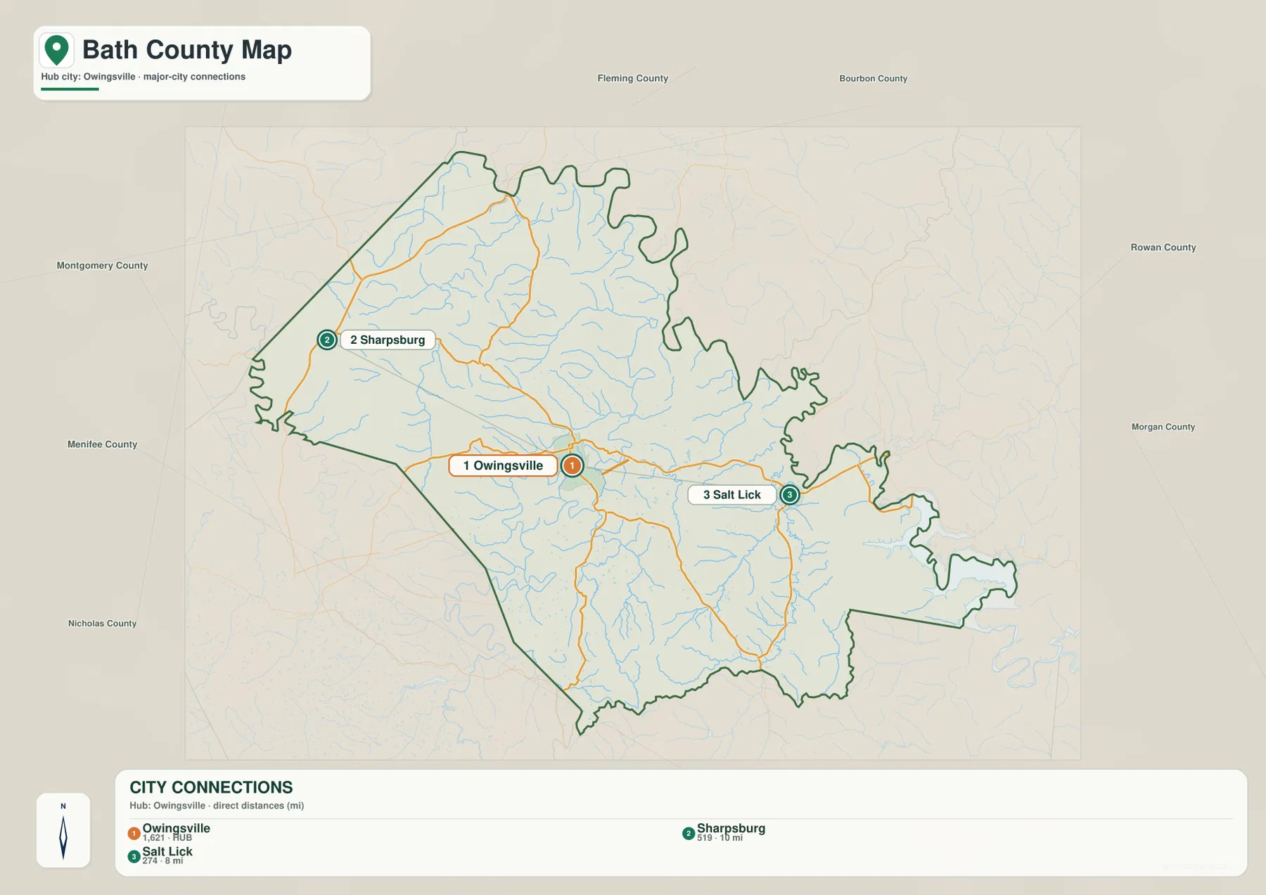
Bath County is therefore less a multi-city urban county than a network of three small communities separated by ridges and drainage valleys. Owingsville functions as the civic center, Sharpsburg gives the western countryside a town reference, and Salt Lick serves as the eastern gateway toward the national forest and lake country.
Flat Creek and Slate Creek carve the central and western hills into narrow ridges
Flat Creek is one of the strongest western drainage lines, running through a long valley fed by many short tributaries. Little Flat Creek and East Fork Flat Creek divide the northern uplands, while White Oak Creek and Prickly Ash Creek create additional narrow corridors across the interior.
Slate Creek forms a major central drainage with broad bends, and Mill Creek approaches from the south. Farther east, Indian Creek, Cow Creek, Salt Lick Creek, and Mud Lick Creek occupy separate valleys. The density of these channels explains why the road map understates how broken and ridge-filled the county actually is.
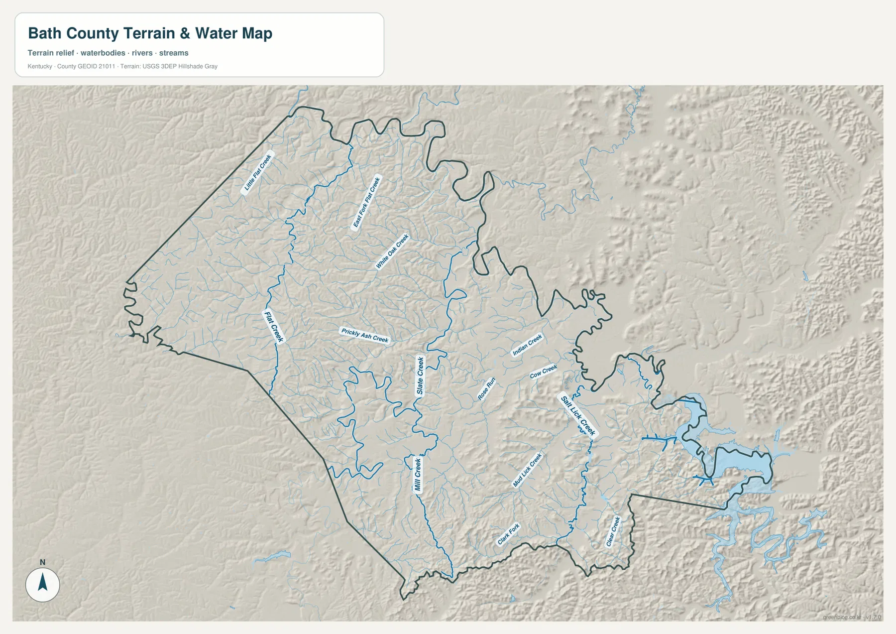
Clark Fork follows the southern side, and Clear Creek cuts through the southeastern forested extension toward Cave Run Lake. The lake surface around Zilpo is much larger than the county’s interior streams, creating a distinct landscape at the far eastern edge.
This image is intended for geographic reference rather than floodplain, navigation, water-quality, parcel, or legal-access decisions. Stream and lake conditions can change, so current agency information should be used whenever boating, fishing, or shoreline access depends on water level or local rules.
Elevation from 180 to 416 meters separates western ridges from lower eastern valleys
The elevation surface ranges from about 180 to 416 meters, with a mean near 260 meters. Higher tan and brown ridges cover much of the west and northwest, with several additional high areas in the central county. Greener lower terrain becomes more continuous toward Salt Lick Creek and the Cave Run Lake side.
The Flat Creek network cuts many narrow valleys into the western uplands. Owingsville sits in intermediate hill country where short ridges alternate with creek bottoms. East of Salt Lick, the land opens into broader low corridors before rising sharply again around the forested ridges that border Cave Run Lake.
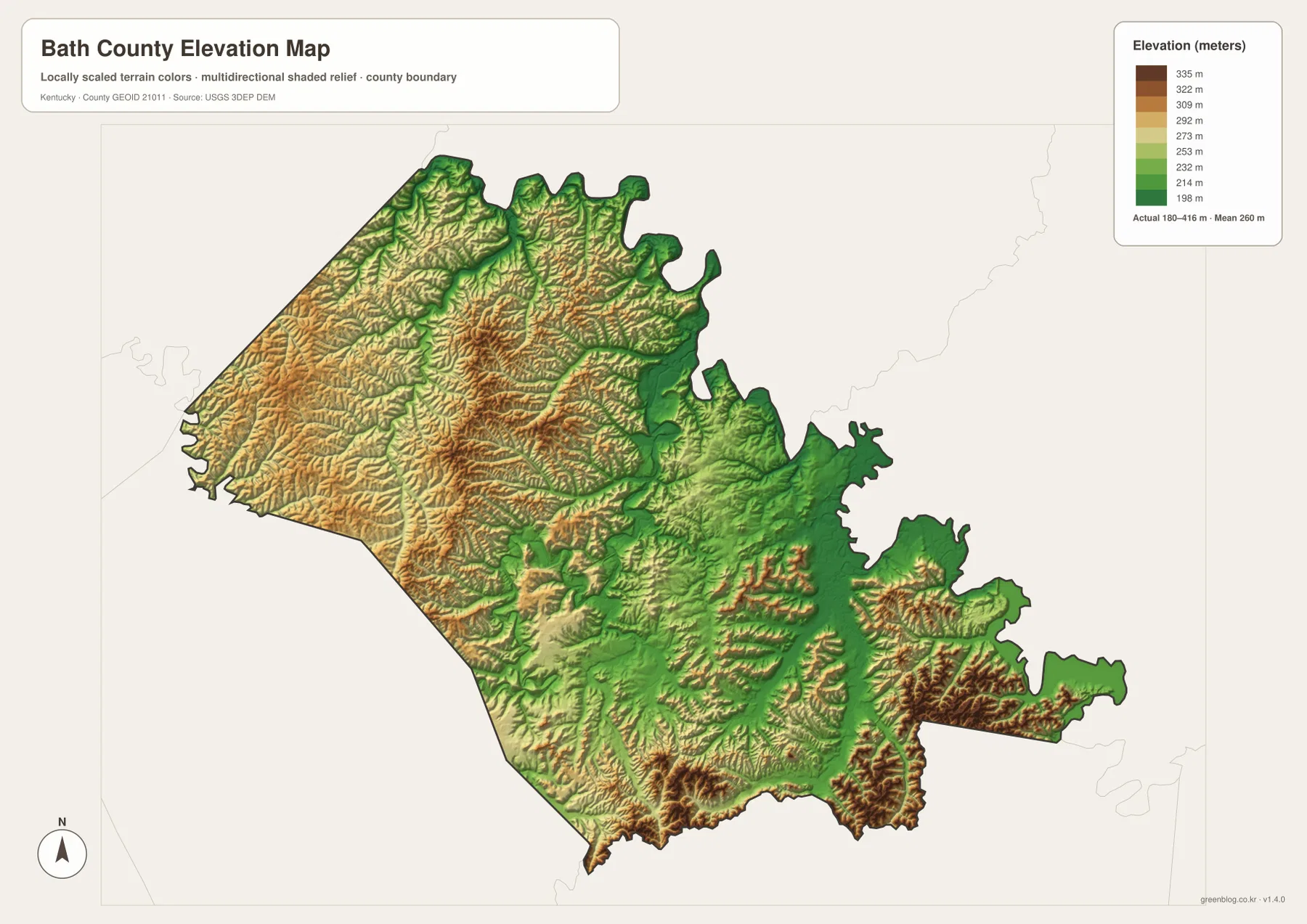
The southern boundary is also rugged. Mill Creek and Clark Fork cut deep channels between narrow ridges, so places that appear close in straight-line distance can require winding road travel. The relief surface makes it easier to see why many local roads follow creek bottoms and lower passes instead of straight lines.
The elevation surface is generalized for county-scale comparison. It is not survey-grade or engineering-grade measurement and should not be used for parcel elevations, construction grades, drainage design, or legal boundary work.
Mineral springs and salt licks gave Bath County its name and shaped early settlement
Bath County’s official history and the Kentucky Historical Society both connect the county name to its many mineral springs. Early settlers used the word “lick” for places where minerals reached the surface and attracted wildlife. The community name Salt Lick preserves that relationship between local geology, water, and early travel.
The county’s official history says settlers were arriving by the 1770s and found abundant game around the mineral licks. Railroad construction in the late nineteenth century later supported a lumber industry based on the surrounding hardwood forests. Today, US 60 and recreation roads toward the national forest have replaced the railroad as more visible movement corridors on the county map.
Cave Run Lake and Zilpo connect southeastern Bath County with Daniel Boone National Forest
Recreation.gov describes Cave Run Lake near Salt Lick as an 8,270-acre reservoir jointly managed by the U.S. Army Corps of Engineers and the U.S. Forest Service. The map shows the lake entering the southeastern extension of Bath County, where Zilpo Recreation Area sits on a peninsula surrounded by forested ridges.
Zilpo Campground provides access to camping, swimming, boating, and hiking in Daniel Boone National Forest. Recreation.gov directions approach the area from Salt Lick at the US 60 and KY 211 junction, then continue by Clear Creek Road and Forest Route 918. That route closely matches the eastern road and water references visible in the supplied county map.
The Owingsville courthouse lawn records both county formation and Civil War loss
A Kentucky Historical Society marker on the Owingsville courthouse lawn records Bath County’s 1811 formation and its mineral-spring name. Another marker at the same civic center describes the destruction of the courthouse during the Civil War in March 1864 after Union troops withdrew ahead of a Confederate force.
The same marker notes that guerrillas later burned many county records in December 1864. These events give the small county seat a historical role that is not obvious from the modern road map and reinforce why Owingsville has remained the administrative center for more than two centuries.
Short trips west and east from Owingsville cross very different landscapes
Traveling west toward Sharpsburg brings the road network into the Flat Creek system and higher, more tightly cut ridges. Heading east toward Salt Lick reaches broader Slate Creek and Salt Lick Creek valleys, then continues toward Cave Run Lake and Daniel Boone National Forest.
The city panel labels Sharpsburg and Salt Lick only about 10 and 8 straight-line miles from Owingsville, yet the water and elevation views show why the two directions feel different. Bath County compresses western ridge country, a central county-seat valley, and eastern lake-and-forest terrain into a relatively short span.
For posters, classroom prints, or presentation slides, use the original JPG files in the download archive rather than enlarging the web previews. Small road labels, creek names, city-connection text, and the elevation legend remain clearer at the higher resolution.
Frequently Asked Questions
Are the 1,621, 519, and 274 values current populations?
No. Owingsville 1,621, Sharpsburg 519, and Salt Lick 274 are map index values supplied with this package. They are separate from current official population statistics. The roughly 10-mile and 8-mile labels are straight-line map distances from Owingsville, not driving distances.
Why are Salt Lick and the Bath County name connected to mineral springs?
Bath County government and the Kentucky Historical Society explain that mineral springs and mineral “licks” were important natural features for early settlers and wildlife. The county name refers to those springs, while the Salt Lick community preserves the older geographic term in its name.
Can the 180–416 meter elevation image be used for surveying?
No. It is a generalized county-scale terrain image for comparing higher western ridges with lower eastern creek and Cave Run Lake terrain. Parcel elevations, engineering grades, drainage design, and legal boundary work require more precise official data and, where needed, professional surveying.
Map File Information
The archive contains the Bath County, Kentucky general county map, city-connections map, terrain-and-water map, and elevation map as original high-resolution JPG files.
- Included Files: Use only the versions confirmed in the article and supplied images
- File Type: Use the confirmed download contents
- Intended Use: Printing, education, presentations, and map-based projects
Related Maps
Sources and references
- Bath County, Kentucky: About Us — county name, Owingsville, mineral licks, railroad, and local industry history
- Kentucky Historical Society: Bath County — 1811 county formation, mineral springs, and Owingsville name origin
- Kentucky Historical Society: Courthouse Burned — Civil War history at the Owingsville courthouse
- Recreation.gov: Cave Run Lake — lake size, management, and recreation information
- Recreation.gov: Zilpo — Zilpo Recreation Area and access from Salt Lick
- USGS 3D Elevation Program — elevation and terrain reference data
Green Map creates custom-edited map images using open geographic data sources such as geoBoundaries, Natural Earth, OpenStreetMap, and government open data. These maps are edited visual materials, not raw data files, and are provided for education, documents, presentations, and graphic reference.