Anderson County lies in central Kentucky, where Lawrenceburg serves as the county seat and the main urban reference in a landscape of rolling ridges, narrow creek valleys, and the Salt River corridor. US 127 and US 62 connect the county with the surrounding Bluegrass region, while KY 44, KY 151, KY 326, KY 395, and smaller state routes spread into the rural interior. The map package also shows a dense drainage network and pronounced local relief despite the county’s relatively compact size. High-resolution map files are available for download in the section below.
This guide follows Lawrenceburg, the main road network, the Salt River, Beaver Lake, and terrain ranging from about 145 to 286 meters. WebP previews are available for quick viewing, and the matching high-resolution JPG files can be downloaded together in one ZIP for printing, classroom work, or offline reference.
Table of Contents
Lawrenceburg anchors the county around US 127 and the central road network
Lawrenceburg sits in the east-central part of Anderson County. US 127 provides the strongest north–south route, while US 62 connects the city with the western countryside. KY 44 approaches from the west, KY 151 and KY 326 provide northern references, and KY 395, KY 749, KY 248, KY 513, and KY 53 divide the southern and western rural areas into smaller road districts.
Lawrenceburg/Anderson County Tourism records that Lawrenceburg was incorporated in 1820 and became the Anderson County seat when the county was created in 1827. The modern map still reflects that role: public services, denser streets, and the largest concentration of development sit around Lawrenceburg.
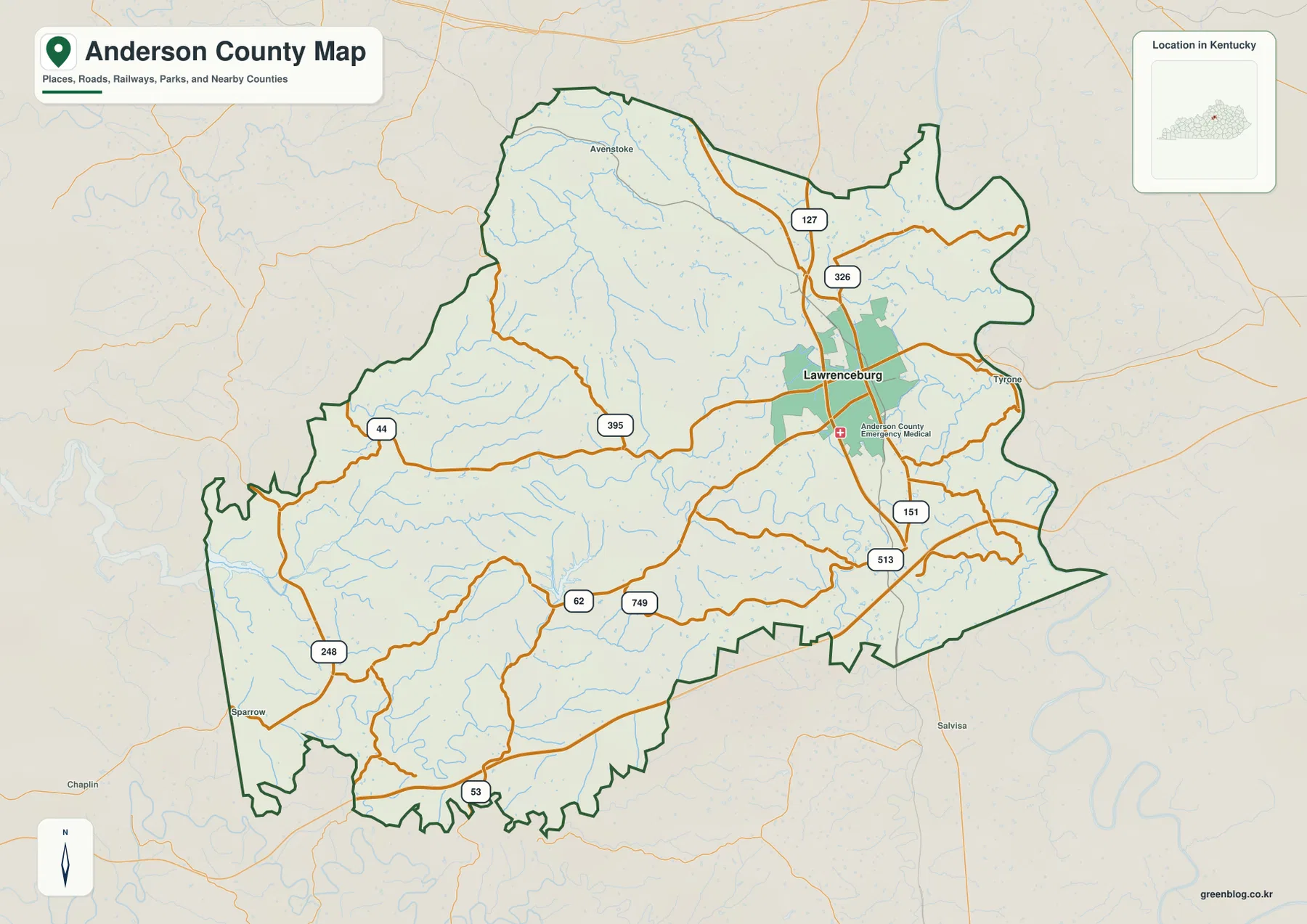
Tyrone provides an eastern reference, Avenstoke lies to the north, and Sparrow appears near the southwestern edge. Franklin and Woodford counties border the eastern side, Mercer County lies to the south, and Spencer and Nelson counties provide western references. The road map makes Lawrenceburg look compact, but the creek and relief views show that the rural surroundings are heavily dissected.
Lawrenceburg is the only community ranked on the city panel
The supplied city panel lists Lawrenceburg at an index value of 11,943 and does not rank another Anderson County city. That number is a map index rather than a current official population estimate. Other place names appear on the general map, but they are not part of the same ranked-city dataset.
The single-city ranking fits the county’s functional pattern. County government, commercial services, and much of the local visitor activity are centered in Lawrenceburg, while the rest of the county is largely rural. Two major bourbon distilleries also use Lawrenceburg as their production and visitor-center location, adding another important role to the county seat.
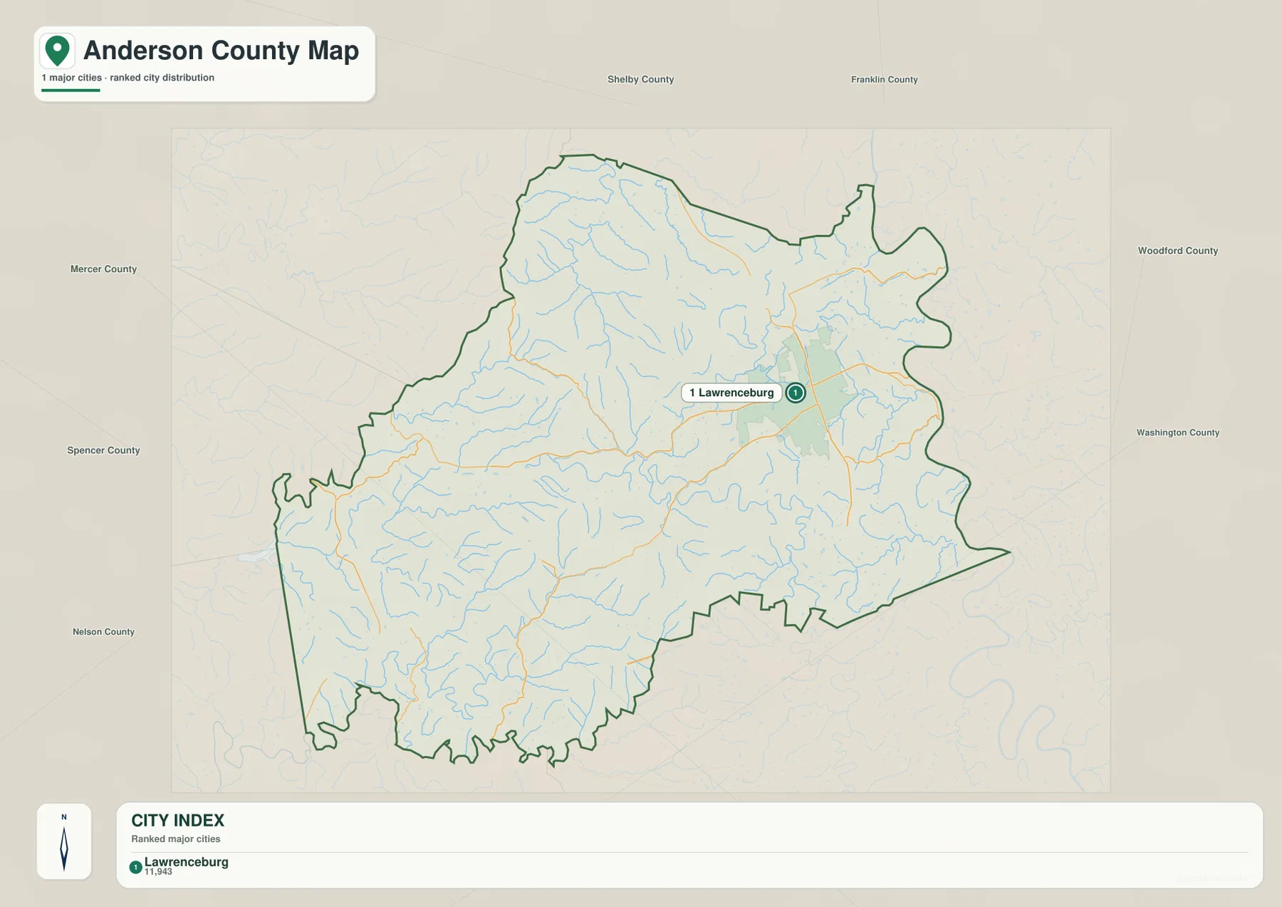
Because this panel contains no connector lines or second ranked city, it should not be treated as a complete population table. The road and water maps provide more useful context for the smaller rural communities and the county’s settlement pattern outside Lawrenceburg.
The Salt River crosses the middle of the county while creeks cut the surrounding hills
The Salt River is the strongest water feature inside the county. It enters from the west, winds across the central interior, and continues east while collecting short tributaries from the surrounding hills. Its valley creates a broad low corridor that becomes especially obvious on the elevation map.
Benson Creek drains the northern interior, while Hammond Creek bends through the northeastern side near Lawrenceburg. Timber Creek and Indian Creek divide the west-central uplands, and Bailey Run and Gilbert Creek provide additional eastern drainage references. The large number of short tributaries shows how thoroughly the county’s rolling surface has been cut by water.
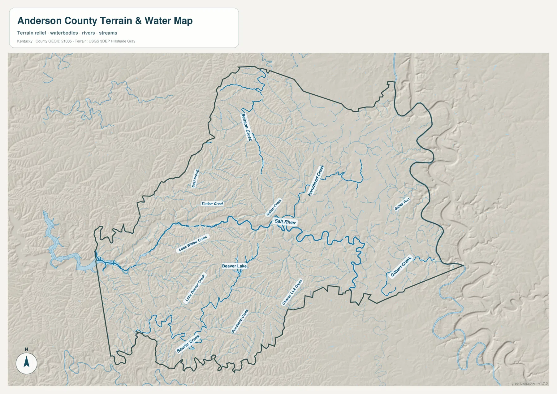
In the southwest, Beaver Creek and Little Beaver Creek surround the Beaver Lake area. Kentucky Department of Fish and Wildlife Resources lists Beaver Lake as an Anderson County waterbody of about 146 acres and provides fishing and boating access information. On the county map it is a small interior lake rather than a large reservoir, but it is a strong geographic reference for the southwestern hills.
This image is intended for geographic reference rather than floodplain, navigation, water-quality, parcel, or legal-access decisions. Stream and lake conditions can change, so current agency information should be used whenever boating, fishing, or shoreline access depends on water level or local rules.
Elevation from 145 to 286 meters separates the Salt River lowland from the ridge country
The elevation surface ranges from about 145 to 286 meters, with a mean near 238 meters. Green lowlands follow the Salt River and major creek valleys, while tan and brown higher ground covers much of the northwest, south, and southeast. More than 140 meters of local relief across the county creates a distinctly rolling landscape.
The northwestern interior is especially broken by narrow ridges and tributary valleys. The Salt River forms a lower cross-county passage through the middle, while the Beaver Lake side and the southern boundary show another dense pattern of high ground divided by creeks.
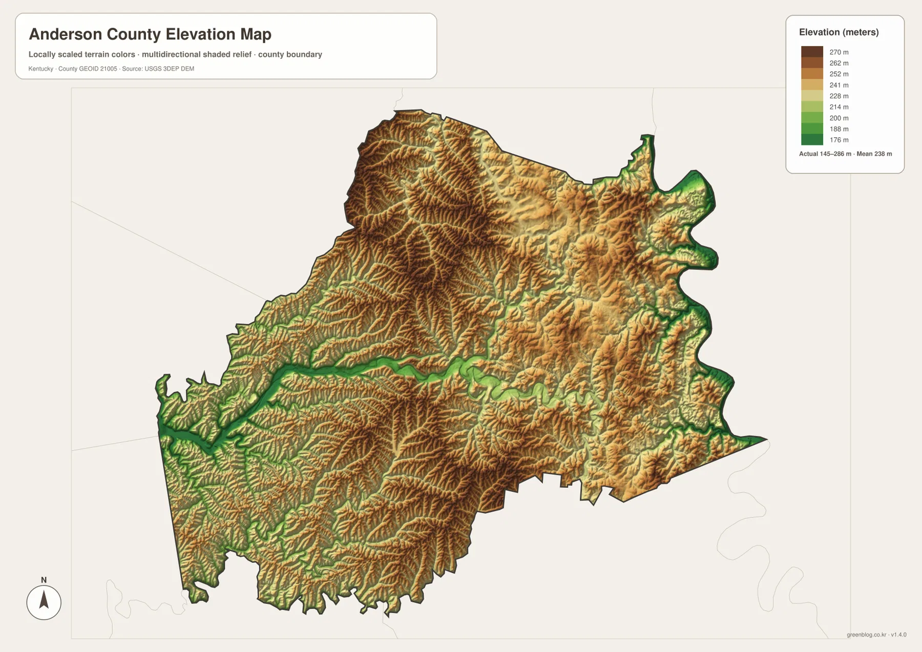
Lawrenceburg occupies intermediate terrain rather than the county’s highest ridges or deepest river bottom. A short trip away from town can move from a ridge into a narrow tributary valley and back again, which helps explain the winding pattern of many rural roads.
The elevation surface is generalized for county-scale comparison. It is not survey-grade or engineering-grade measurement and should not be used for parcel elevations, construction grades, drainage design, or legal boundary work.
Lawrenceburg’s bourbon industry adds a distinctive layer to the county map
Lawrenceburg/Anderson County Tourism presents bourbon as a major part of local identity. Four Roses operates its Distillery & Visitor Center in Lawrenceburg, and Wild Turkey also identifies Lawrenceburg as the home of its distillery campus. These facilities make the county seat unusual for a small central Kentucky city because industrial heritage and visitor activity are concentrated alongside county government and ordinary local services.
Four Roses lists its Lawrenceburg distillery at Bonds Mill Road, while Wild Turkey’s visitor material places its distillery on Wild Turkey Hill near Lawrenceburg. The detailed facility footprints are not the purpose of the county map, but the road framework around Lawrenceburg helps explain why the city remains the practical center for both residents and bourbon visitors.
The county name and Lawrenceburg’s seat date to 1827
A Kentucky Historical Society marker explains that Anderson County was created in 1827 and named for Richard Clough Anderson Jr. Lawrenceburg became the county seat that same year and developed as a regional center for agriculture, commerce, and government.
Local tourism history notes that Lawrenceburg survived several major fires and retained a downtown commercial district with numerous historic buildings. The current courthouse dates to 1915, and the historic South Main Street area contains homes associated with families that helped build Anderson County’s bourbon industry.
Beaver Lake and the Salt River corridor reveal two different parts of the county
Traveling southwest from Lawrenceburg toward Beaver Lake leaves the broader Salt River corridor and enters a tighter landscape of Beaver Creek, Little Beaver Creek, and short ridges. The lake sits within this more broken terrain rather than on a broad flat plain.
North and northeast of Lawrenceburg, Benson Creek and Hammond Creek divide another set of high ridges, while Bailey Run and Gilbert Creek cut the eastern edge. Comparing the road, water, and elevation views makes it clear that Anderson County is not simply a flat Bluegrass county; its small streams and ridge network strongly shape roads and settlement.
For posters, classroom prints, or presentation slides, use the original JPG files in the download archive rather than enlarging the web previews. Small road labels, creek names, Lawrenceburg text, and the elevation legend remain clearer at the higher resolution.
Frequently Asked Questions
Why does the city map show only Lawrenceburg?
The supplied ranked-city dataset contains one Anderson County entry: Lawrenceburg at 11,943. Other place names appear on the general county map, but they are not included in the city ranking panel, and 11,943 should not be treated as a current official population count.
Where is Beaver Lake on the county map?
Beaver Lake is in southwestern Anderson County near the Beaver Creek and Little Beaver Creek drainage network. Kentucky Department of Fish and Wildlife Resources lists it at about 146 acres and provides current fishing and boating access information.
Can the 145–286 meter elevation image be used for surveying?
No. It is a generalized county-scale terrain image for comparing the low Salt River and creek valleys with higher northwestern and southern ridges. Parcel elevations, engineering grades, drainage design, and legal boundary work require more precise official data and, where needed, professional surveying.
Map File Information
The archive contains the Anderson County, Kentucky general county map, city map, terrain-and-water map, and elevation map as original high-resolution JPG files.
- Included Files: Use only the versions confirmed in the article and supplied images
- File Type: Use the confirmed download contents
- Intended Use: Printing, education, presentations, and map-based projects
Related Maps
Sources and references
- Lawrenceburg/Anderson County Tourism: History — Lawrenceburg incorporation, county-seat history, downtown, and bourbon heritage
- Kentucky Historical Society: County Named, 1827 — Anderson County naming and creation background
- Kentucky Department of Fish and Wildlife Resources: Beaver Lake — lake size and fishing/boating access information
- Four Roses: Lawrenceburg Distillery & Visitors Center — Lawrenceburg distillery and visitor information
- Wild Turkey: Lawrenceburg Distillery — Lawrenceburg distillery and local visitor context
- USGS 3D Elevation Program — elevation and terrain reference data
Green Map creates custom-edited map images using open geographic data sources such as geoBoundaries, Natural Earth, OpenStreetMap, and government open data. These maps are edited visual materials, not raw data files, and are provided for education, documents, presentations, and graphic reference.