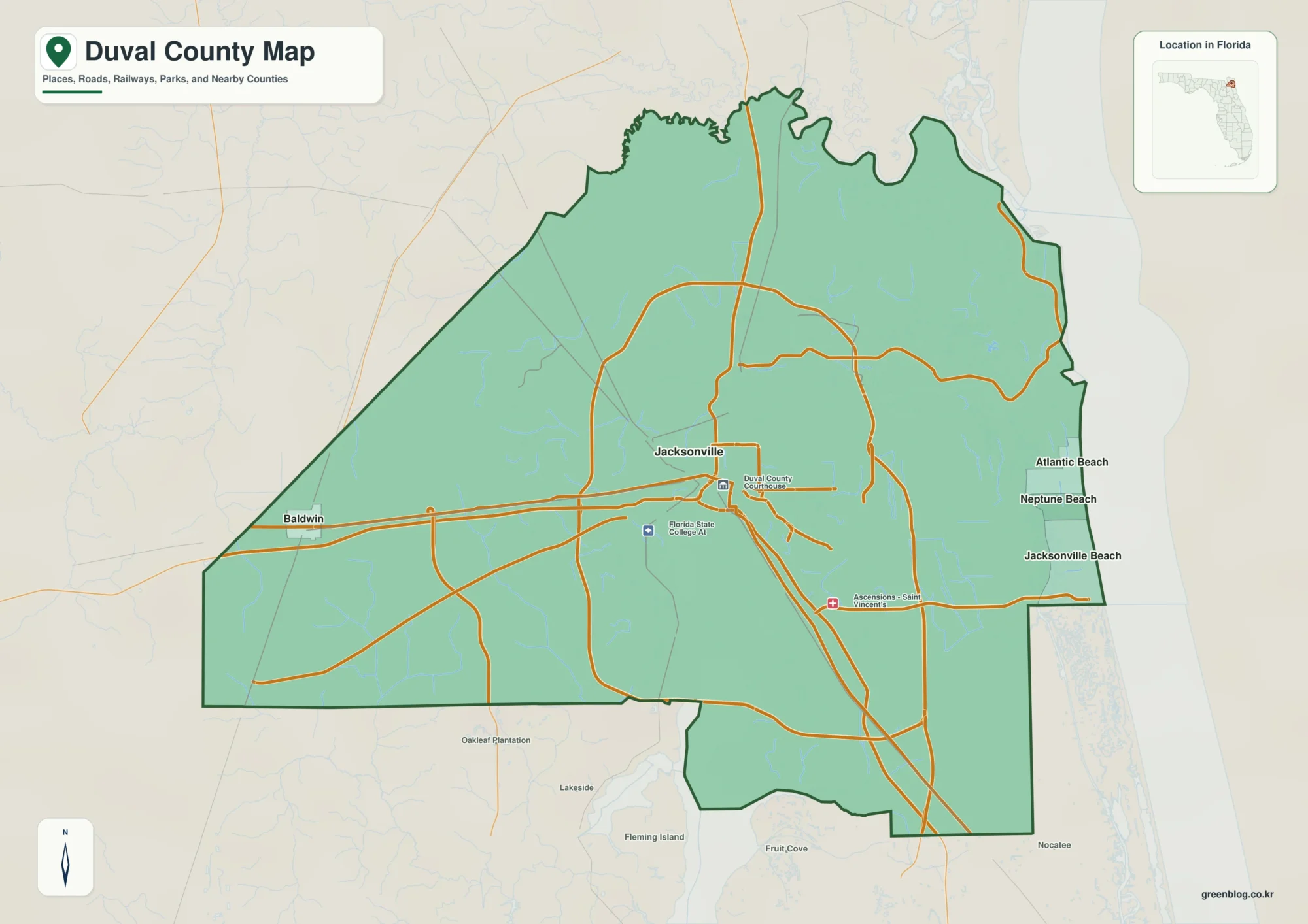
Meade County is easiest to understand by starting with three towns: Plains on the west, Meade near the center, and Fowler to the northeast. US 54 connects all three, while US 160 and K-23 add major route references around Meade. North of the county’s midpoint, towns and highways are relatively easy to follow; farther south, the map is dominated by open rural land and a dense network of small creek valleys. High-resolution map files are available for download in the section below.
This guide uses the four supplied map layers to explain roads, town spacing, drainage, and elevation without turning the page into a technical report. WebP images are provided for quick viewing, and a ZIP containing the original high-resolution JPG files is available for printing, teaching, or offline use. Crooked Creek, Sand Creek, the Cimarron River, and the 637–862 meter elevation range give Meade County a much more varied landscape than the straight road grid might suggest.
Table of Contents
US 54 lines up the county’s three main towns from west to northeast
The general road map becomes simple once US 54 is identified. Plains sits near the western edge, Meade lies near the middle, and Fowler is farther northeast. Because the same highway serves all three, it creates a clear town-to-town sequence across the northern half of the county and provides the easiest first reference for a reader who does not know the area.
Meade itself is a useful second reference because US 160 and K-23 are also shown there. K-23 continues south into a much more lightly settled part of the county, where long rural roads cross many small drainage channels. The northern road grid is comparatively regular, but the terrain beneath it is not perfectly flat, and the stream network becomes more obvious when the water and elevation layers are opened.
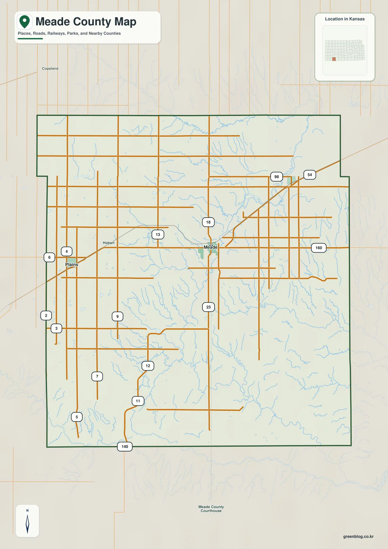
The county outline is slightly irregular rather than a perfect rectangle. Insets along the west-central and northeastern sides change the county width at different latitudes. Gray County is to the north, Clark County to the east, Seward County to the west, and Haskell County toward the southwest, placing Meade County firmly in the southwestern Kansas county grid.
The city-connections view puts Meade between Plains and Fowler
The simplified city map focuses on just Plains, Meade, and Fowler. Its printed index lists Meade at 1,341, Plains at 1,171, and Fowler at 599, with Meade marked as the hub. Those figures are values used on the supplied map rather than a replacement for the latest official population estimates, but they help explain the relative emphasis of the three communities.
The same panel shows direct distances of about 14 miles from Meade to Plains and 11 miles from Meade to Fowler. Plains lies west of the hub, while Fowler is northeast, so the three towns form a diagonal arrangement similar to the course of US 54. The large southern half of the county contains no city marker of comparable size on this view, which makes the north-central concentration of settlement easy to see.
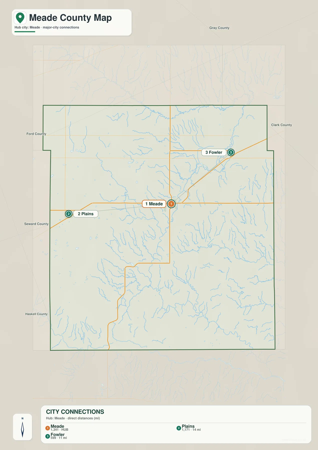
This town-focused layer is useful for basic orientation but less useful in the rural south. Once K-23 leaves Meade, the map contains far more drainage features than settlement labels. That is where the terrain-and-water and elevation maps become the better tools for understanding what lies between the roads.
Crooked Creek, Sand Creek, and Spring Creek break up the open plains
Crooked Creek is one of the most prominent named waterways on the physical map. It approaches from the northeast, bends toward the interior, and receives several smaller tributaries. Sand Creek occupies the eastern and southeastern side of the county, where it runs through a broader low corridor and is joined by Oil Creek and other smaller channels.
Spring Creek crosses the west-central interior, and Lake Larrabee is labeled nearby. Shorts Creek and several arroyo channels appear farther south and west. These features matter because they show that the High Plains surface is repeatedly cut by narrow valleys even though many roads above it follow long straight lines.
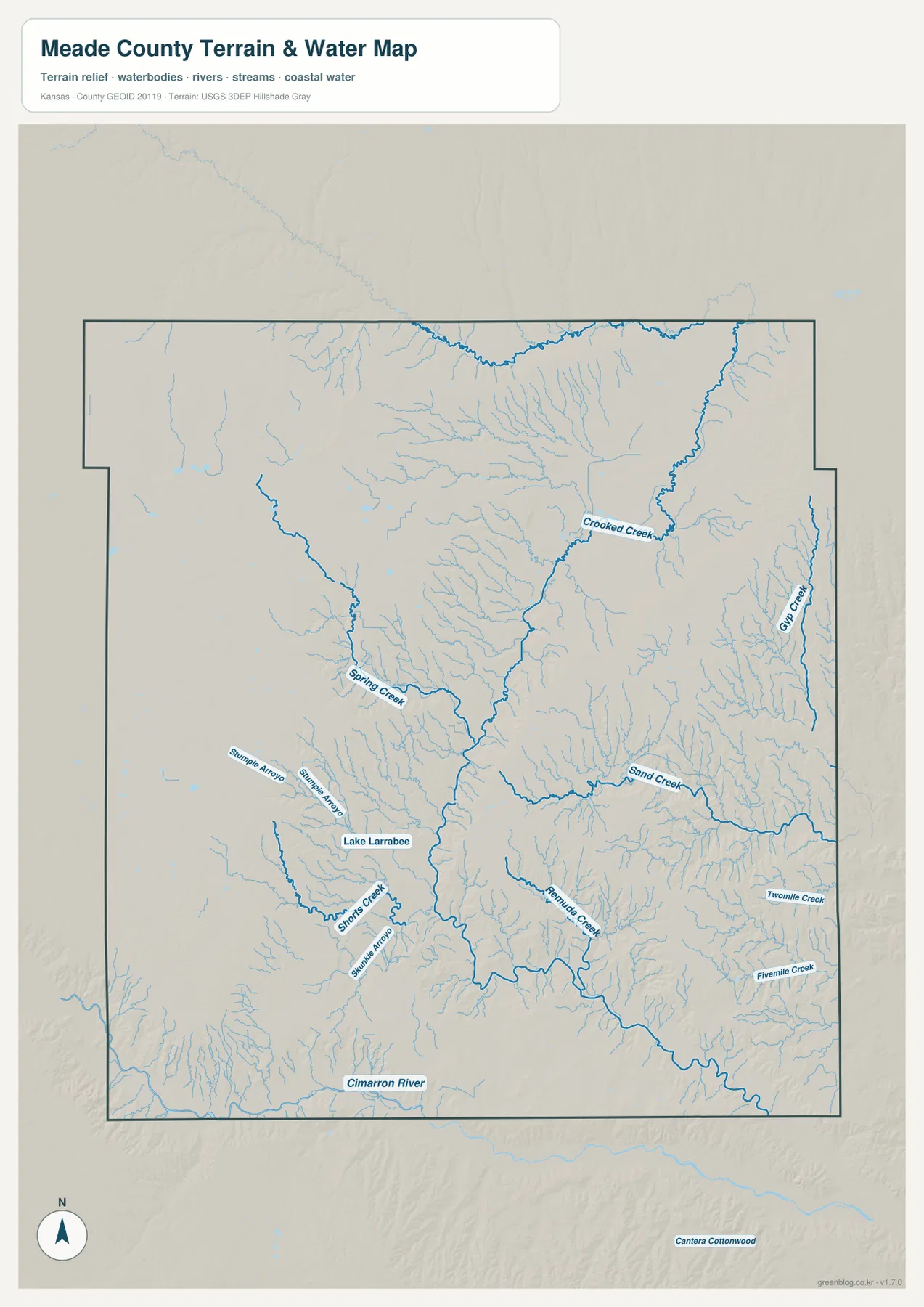
The Cimarron River appears along the southwestern edge of the county. Kansas Geological Survey material places Meade County within the High Plains and Plains Border sections of the Great Plains and identifies the Cimarron River, Crooked Creek, and Sand Creek as important drainage features. The map matches that description: the large river touches the southwest, while smaller creeks shape most of the interior.
This water layer is intended for geographic reference. It does not show current depth, flood risk, water quality, legal access, or safe boating conditions. Seasonal or intermittent channels can look very different on the ground, so site-specific decisions should be checked against current official information.
Elevation drops from the western High Plains toward eastern creek valleys
The elevation map spans about 637 to 862 meters, with a mean near 772 meters. The highest broad areas are in the west and northwest, where brown and dark tan colors dominate. Moving east and southeast, the surface shifts into yellow and green, creating a clear county-wide descent from the higher western plains toward lower drainage corridors.
The change is not a smooth ramp. Crooked Creek, Sand Creek, and many smaller tributaries cut lower strips into the landscape, while higher ground remains between them. These branching valleys are easiest to see in the central and eastern parts of the county, where green fingers extend into otherwise higher terrain.
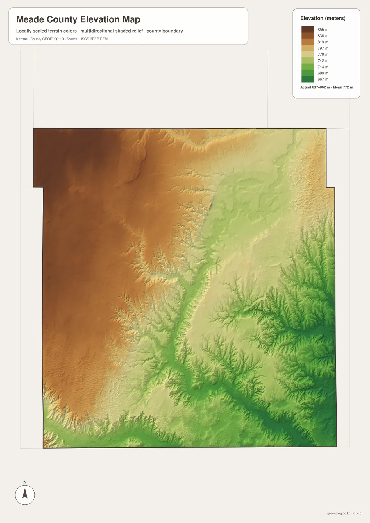
West of Plains and across the northwest, high colors remain broad and continuous. Around Meade and eastward toward Fowler, lower valleys appear more often and create a more complex patchwork. The water map helps explain those colors because many of the green or yellow-green depressions line up directly with named or unnamed drainage channels.
This county-scale elevation image is not a surveying or engineering product. It can show that one broad area is higher than another, but it should not be used to establish parcel elevations, construction grades, drainage design, or legal boundaries. Detailed site work requires more precise official elevation data and, when appropriate, field surveying.
K-23 carries the map south from Meade toward the state park area
K-23 is the easiest road to follow when moving from the city of Meade into the southern part of the county. The Kansas Department of Wildlife and Parks places Meade State Park roughly eight miles south and five miles west of the city. The park and Meade Lake provide a useful local reference in a part of the county where town labels become sparse.
On the elevation map, this southward route crosses the transition between higher western ground and lower central drainage. The water layer adds Spring Creek and several smaller channels, making it easier to see why the rural south feels different from the US 54 town corridor. Here the physical landscape matters more than the spacing between communities.
Straight rural roads can hide how deeply the High Plains surface is cut
From the road map alone, Meade County can look like a broad, orderly plain because many rural roads form long straight lines. The physical maps tell a different story. Small creeks and arroyos repeatedly cut into the surface, especially across the central, eastern, and southeastern parts of the county.
The western side still contains drainage cuts, but higher terrain remains more continuous there. Farther east, the valleys branch more densely and lower the surface in narrow strips. That difference is why the water and elevation maps are useful companions to the road map: they reveal terrain that the highway grid does not show clearly.
Pick the layer that fits the question
Use the general county map when the goal is to locate Plains, Meade, Fowler, US 54, US 160, K-23, and the surrounding county boundaries in one view. The city-connections map is better when you only need the three main towns and their direct spacing from the Meade hub.
Choose the terrain-and-water map for Crooked Creek, Sand Creek, Spring Creek, Lake Larrabee, and the Cimarron River. Use the elevation layer when you want to compare the high western plains with lower creek valleys. Switching between those two physical maps makes the county’s west-to-east drop much easier to understand.
For large prints or presentation slides, use the original JPG files in the download archive rather than enlarging the web previews. The high-resolution files preserve small road shields, creek labels, town names, and the elevation legend more clearly. If you crop a map for a handout, keep enough context—such as a north arrow, highway number, or legend—to make the selected area understandable.
Frequently Asked Questions
How are Plains, Meade, and Fowler arranged?
They follow the US 54 corridor from west to northeast: Plains is on the west, Meade is near the center, and Fowler is farther northeast. The city-connections panel shows direct distances of about 14 miles from Meade to Plains and 11 miles from Meade to Fowler.
Where does the Cimarron River appear in Meade County?
The Cimarron River touches the southwestern edge of the county. Most of the interior is shaped by smaller drainage lines such as Crooked Creek, Sand Creek, Spring Creek, and numerous unnamed tributaries and arroyos.
Can the 637–862 meter elevation map be used for surveying?
No. It is a generalized county-scale surface for comparing uplands and valleys. Parcel elevations, engineering grades, drainage design, and boundary work require more precise official data and, where needed, professional surveying.
Map File Information
The archive contains the Meade County, Kansas general map, city-connections map, terrain-and-water map, and elevation map as original high-resolution JPG files.
- Included Files: Use only the versions confirmed in the article and supplied images
- File Type: Use the confirmed download contents
- Intended Use: Printing, education, presentations, and map-based projects
Related Maps
Sources and references
- Kansas Department of Wildlife and Parks: Meade State Park — park and lake location south of Meade
- Kansas Geological Survey: Geology and Ground-water Resources of Meade County — High Plains setting and major drainage features
- U.S. Census Bureau TIGER/Line Shapefiles — county boundary and geographic reference data
- USGS National Hydrography — river and stream reference data
- USGS 3D Elevation Program — elevation and terrain reference data
Green Map creates custom-edited map images using open geographic data sources such as geoBoundaries, Natural Earth, OpenStreetMap, and government open data.
These maps are edited visual materials, not raw data files, and are provided for education, documents, presentations, and graphic reference.