Marshall County occupies Kansas’s northern border with Nebraska, with Marysville serving as the most prominent center on the maps. US 36 crosses east–west through Marysville, while US 77 runs north–south toward the state line and Blue Rapids. Waterville and Blue Rapids form a southwestern pair, Frankfort stands apart in the southeast, and Beattie and Axtell occupy the northeastern half. The result is a county whose towns are spread across several river valleys and road corridors rather than clustered in one compact area. High-resolution map files are available for download in the section below.
The four maps on this page connect that settlement pattern with the Big Blue, Little Blue, and Black Vermillion river systems and an elevation range of about 328–468 meters. WebP previews make the maps easy to view online, and the original high-resolution JPG versions can be downloaded together in one ZIP for printing, teaching, or offline reference. Switching between layers is especially helpful around Marysville, the southwestern Blue River valleys, and the higher northeastern uplands.
Table of Contents
Marysville sits at the county’s clearest highway crossroads
Marysville is the strongest orientation point on the general county map. US 36 runs through the city from west to east, and US 77 crosses it on a north–south line. Because those two federal highways meet there, Marysville provides a practical reference for reaching the western boundary, the Beattie–Axtell area to the east, the Nebraska line to the north, and Blue Rapids to the south. Rail lines are also visible around the city, adding another transportation feature to an otherwise rural road network.
East of Marysville, US 36 passes Home and continues toward Beattie and Axtell. Southbound US 77 leads toward the Blue Rapids area, where K-9 provides an east–west link near Waterville. Frankfort lies farther southeast and is easiest to locate from K-99, while K-87 crosses part of the eastern county and K-110 reaches the Axtell area. These routes are separated enough that the county is easier to understand as several connected corridors rather than one central highway grid.
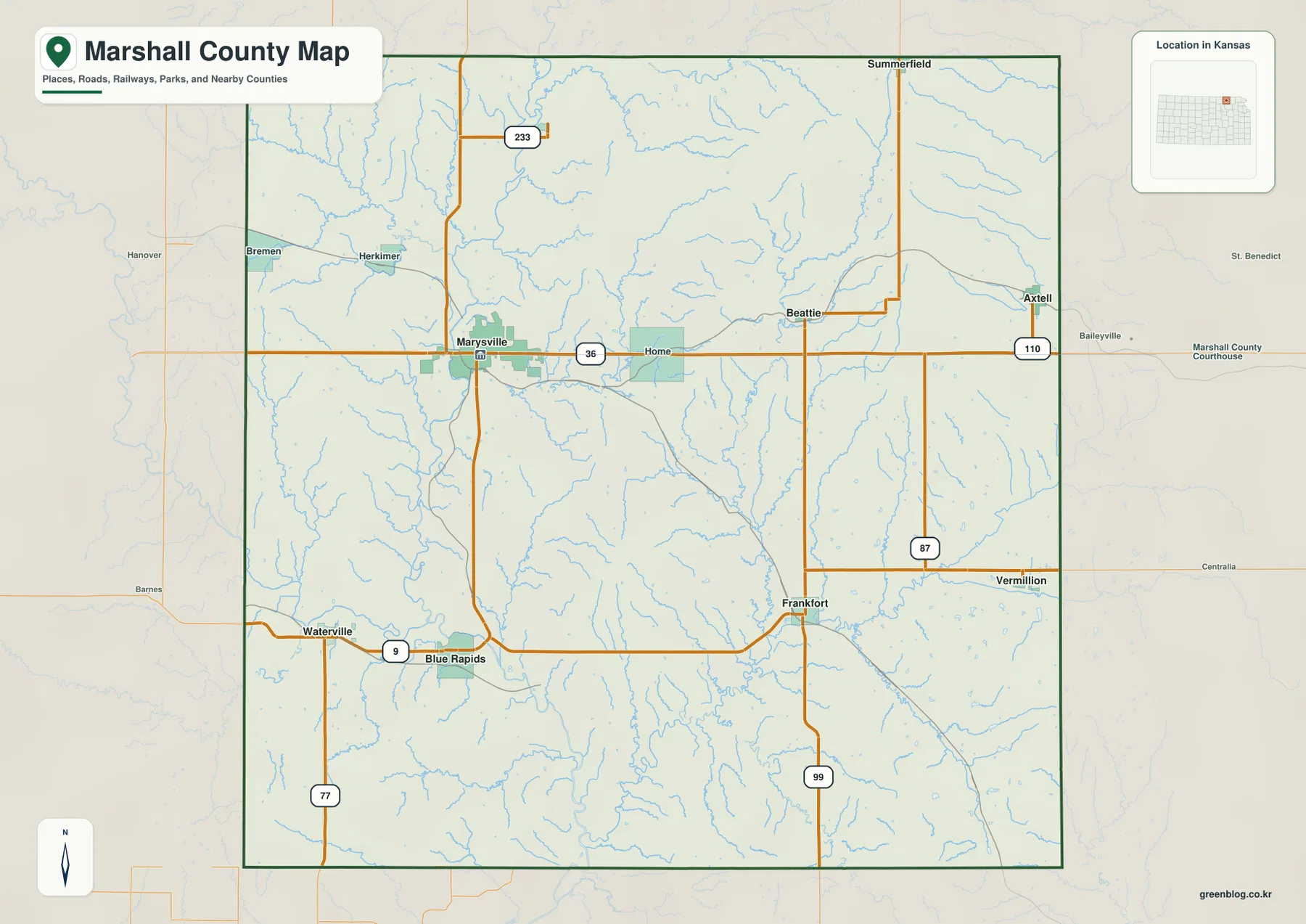
The northern edge of Marshall County is the Kansas–Nebraska state line. Summerfield appears close to that boundary, while Axtell and Beattie occupy the northeastern portion of the county farther south. Smaller places such as Bremen, Herkimer, Home, and Vermillion fill the spaces between the major city labels. Taken together, the map shows a broad rural county with a relatively dense network of small settlements rather than a single urbanized core.
Six ranked cities form separate northern, southwestern, and southeastern groups
The city-distribution map highlights six major communities and removes much of the highway clutter. Its city index ranks Marysville first at 3,422, followed by Blue Rapids at 870, Waterville at 748, Frankfort at 726, Axtell at 468, and Beattie at 185. These are the values printed on the supplied city map and should be treated as its ranking index rather than as a replacement for the latest official population estimate.
Geography is more revealing than the ranking alone. Marysville occupies the northwestern side of the county’s central band, while Beattie and Axtell form a northeastern group. Blue Rapids and Waterville are close together in the southwest, but Frankfort is separated from them in the southeast. That layout creates several distinct town-to-town relationships: Marysville to Axtell along the US 36 corridor, Marysville to Blue Rapids along US 77, and Frankfort on a different southern route system.
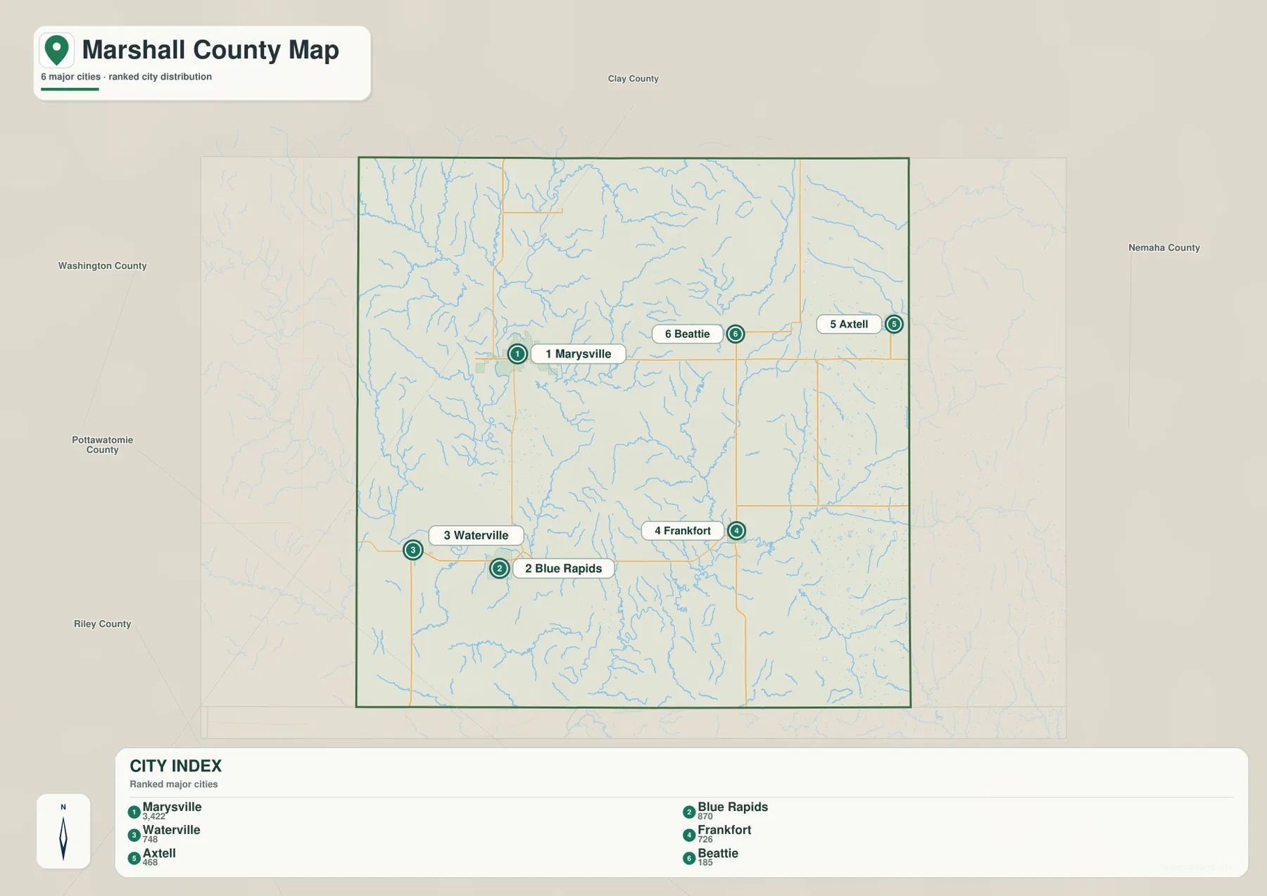
This simplified view is useful for choosing a general direction before checking roads. US 36 is the natural reference for Marysville, Beattie, and Axtell; US 77 links Marysville with the Blue Rapids direction; K-9 helps locate Waterville; and K-99 provides the clearest route reference for Frankfort. Smaller towns and unincorporated places are not all part of the six-city index, so the general map remains necessary when a destination falls outside the ranked set.
The Big Blue and Little Blue carve broad western and southwestern valleys
The western half of the terrain-and-water map is dominated by the Big Blue River system. Major channels descend from the north and gather tributaries such as Horseshoe Creek and Deer Creek before continuing through a wider lowland south of Marysville. The Little Blue River occupies the southwest and forms another strong valley near the Waterville–Blue Rapids part of the county. These broad channels are much more prominent than the many short creeks branching from the uplands.
Farther south, the Big Blue River bends through the county and receives smaller drainage lines including Clear Fork and Game Fork. The channels do not run as straight lines across a level plain; they curve around hills, widen in lower ground, and narrow where the surrounding relief closes in. The shaded terrain behind the blue waterways makes those valley shapes visible without needing a separate contour map.
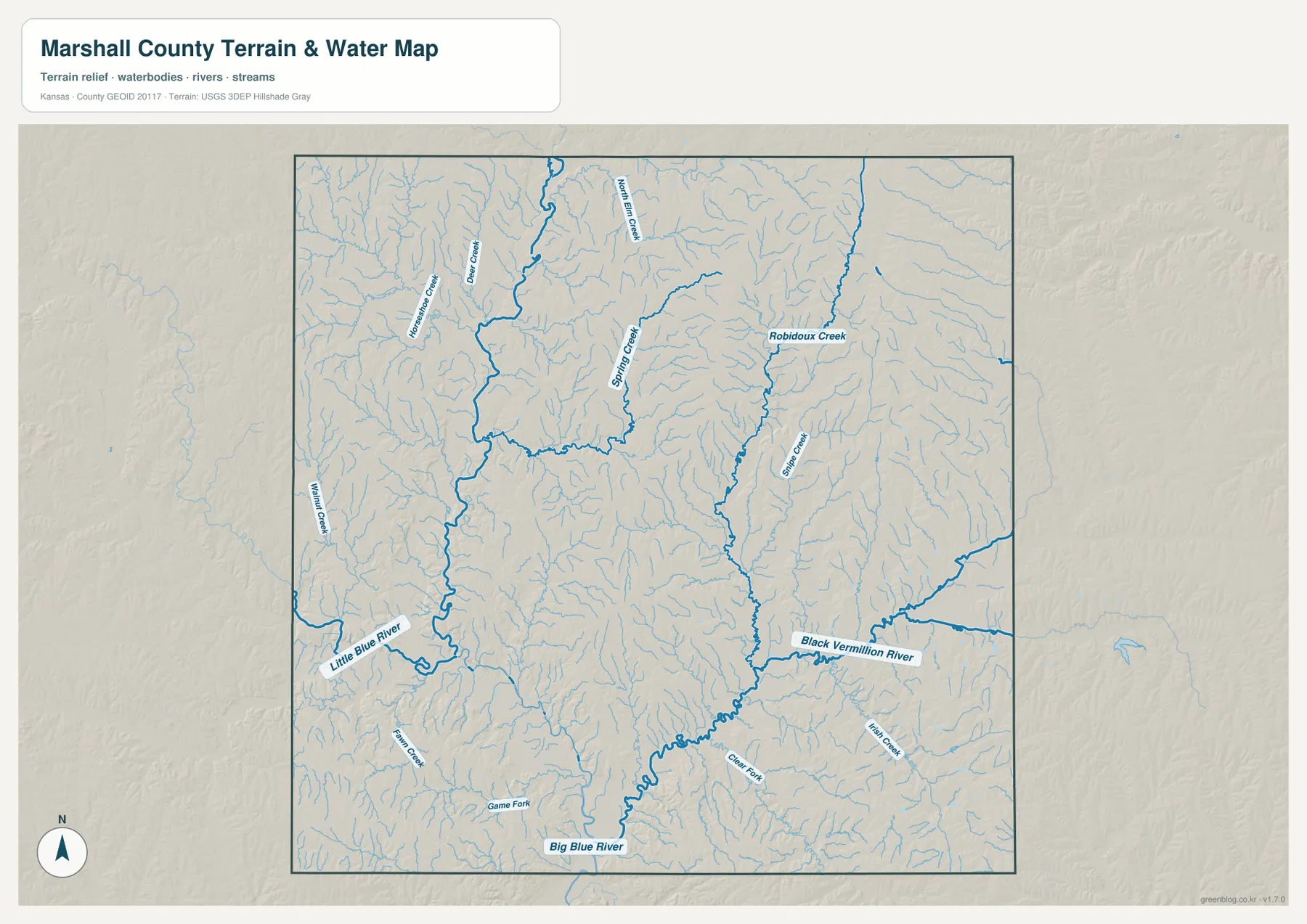
Eastern Marshall County belongs to a different visible drainage pattern. Robidoux Creek and Spring Creek run southward through the northeastern uplands, and the Black Vermillion River becomes the main low corridor in the southeast. Elm Creek and many unnamed or lightly labeled tributaries feed that system. At county scale, the western Big Blue network and eastern Black Vermillion network create two strong drainage landscapes separated by rolling uplands.
This map is designed for geographic reference rather than flood-zone, navigation, parcel, or water-access decisions. A mapped river or creek does not indicate current depth, flow, public entry, or safe boating conditions. Flood risk, water conditions, and site-specific access should be checked with current agency information when those details matter.
A 328–468 meter elevation range exposes low river corridors and higher northeastern ridges
The elevation map spans roughly 328 to 468 meters, with a mean near 395 meters. Green tones follow the lowest corridors, especially along the Big Blue River through the west-central and southern portions of the county. The Little Blue valley is also low in the southwest, and the Black Vermillion drainage creates another broad green corridor toward the southeast. These low zones stand out sharply against surrounding tan and brown ridges.
The most extensive high terrain appears in the northeast. Long brown ridges and narrow incised valleys surround the Axtell–Beattie side of the county, and another north–south band of higher relief occupies the central-eastern interior. Western and southwestern uplands also rise above the river floors, but the nearby Big Blue and Little Blue valleys create stronger local contrasts. The result is a landscape of dissected uplands rather than a uniformly flat northern Kansas surface.
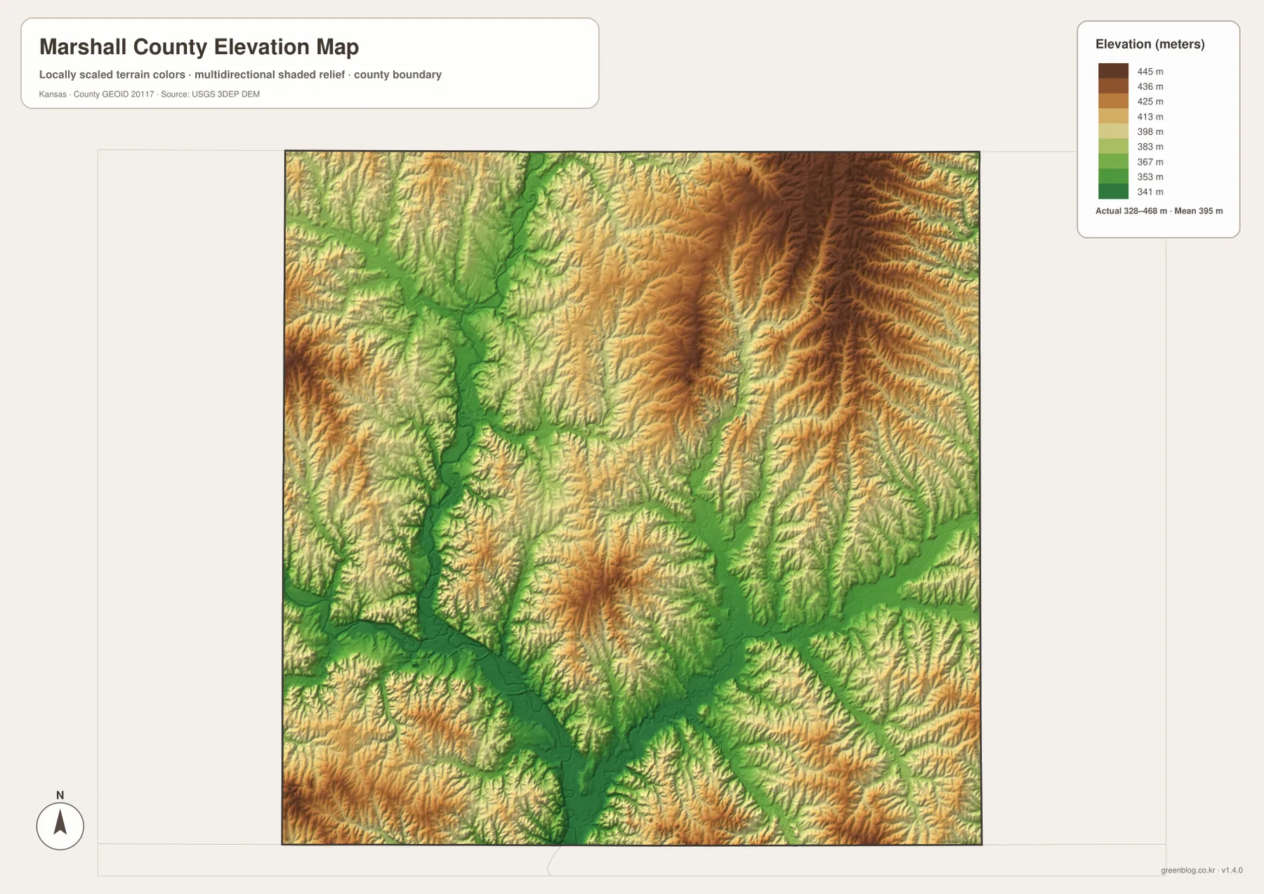
Comparing elevation with waterways explains much of the map’s texture. The broad green strip along the Big Blue River widens where tributaries join the main valley, then narrows between higher ridges. In the east, the Black Vermillion River occupies a similarly low route beneath surrounding uplands. Smaller creeks climb into the hills as thin green fingers, showing where local drainage begins before descending toward the larger channels.
The elevation surface is generalized for county-scale comparison and is not survey-grade or engineering-grade measurement. It can show that a river valley is lower than an adjacent ridge, but it should not be used to determine a parcel elevation, building pad, drainage grade, or legal boundary. Detailed site work requires appropriate high-resolution elevation data and, when necessary, professional surveying.
The Nebraska boundary and US 36 shape the northern half of the county
Marshall County occupies the first tier of Kansas counties south of Nebraska. Kansas Geological Survey geography material places Washington County to the west, Nemaha County to the east, and Riley and Pottawatomie counties to the south. That border position is visible on the road network: US 77 runs north from Marysville toward the Kansas–Nebraska line, while US 36 crosses the county just below many of the northern communities.
US 36 is therefore more than a local east–west road. It ties Marysville to Beattie and Axtell within the county and continues toward neighboring northern Kansas counties. Marshall County Travel & Tourism describes the area as a crossroads on two federal highways, which fits the supplied map closely. Rail lines also parallel parts of this settlement belt, especially around Marysville and the eastern towns, reinforcing the concentration of transportation features in the northern half.
Marysville to Blue Rapids shows the clearest relationship between roads, valleys, and towns
The Marysville–Blue Rapids corridor is a useful example of how the map layers work together. On the general map, US 77 provides a clear north–south connection. The terrain-and-water view adds the Big Blue River and nearby tributaries, showing that the route crosses a landscape shaped by broad river lowlands rather than a featureless plain. The elevation map then makes the same valley visible as a long green depression between higher ground.
Waterville lies west of Blue Rapids near K-9 and belongs to the Little Blue–Big Blue valley setting. Frankfort, by contrast, is farther east and relates more closely to the Black Vermillion drainage. That difference matters when comparing southern towns: they may appear at similar latitudes, but their surrounding waterways and relief are not the same. The city map supplies the town spacing, while the water and elevation layers explain the terrain between them.
Marysville’s location also has a documented historical connection with the Big Blue River and major travel routes. Marshall County Travel & Tourism describes the town’s origins around a trading post and ferry crossing and notes its continuing highway and railroad role. The modern map does not function as a history map, but this background helps explain why the county’s largest mapped center developed at such a strong transportation and river crossing point.
Match the map to the question instead of forcing every detail into one view
Use the general map when roads, towns, the state line, and overall county orientation matter most. It is the best starting point for locating Marysville on US 36 and US 77, then following routes toward Blue Rapids, Frankfort, Axtell, or smaller communities. The city map is cleaner when the goal is simply to compare the six ranked centers without highway and terrain detail.
Choose the terrain-and-water map for river systems, named creeks, and the relationship between drainage and local relief. The elevation map is strongest when comparing the Big Blue valley with higher northeastern ridges or when explaining why stream corridors appear as long low bands. Moving from the general map to one specialized layer usually answers a question more clearly than trying to read every symbol at once.
For large prints and presentation slides, the original JPG files in the ZIP preserve small road numbers, creek names, city labels, and the elevation legend better than an enlarged web preview. If only part of a map is cropped for a handout, keep enough surrounding context—such as a highway number, north arrow, or elevation key—to make the selected area understandable on its own.
Frequently Asked Questions
Which map is best for distinguishing Blue Rapids from Axtell relative to Marysville?
Start with the general county map. Blue Rapids lies south of Marysville along the US 77 direction, while Axtell is east of Marysville along the broader US 36 corridor. The city map is useful as a second view when you want only the relative placement of the major communities without route detail.
Do the Big Blue River and Black Vermillion River follow the same part of Marshall County?
No. The Big Blue system dominates the west-central and southern portion of the county, while the Black Vermillion forms a major low corridor in the east and southeast. Their tributaries create different drainage patterns on opposite sides of the county, which becomes especially clear when the water map is compared with the elevation layer.
Can the 328–468 meter elevation map be used for surveying or construction design?
No. It is a generalized county-scale surface for comparing valleys and uplands. Parcel elevations, construction grades, drainage design, and boundary work require more precise official data and, where appropriate, professional field surveying.
Map File Information
The archive contains the Marshall County, Kansas general county map, city map, terrain-and-water map, and elevation map as original high-resolution JPG files for printing and offline use.
- Included Files: Use only the versions confirmed in the article and supplied images
- File Type: Use the confirmed download contents
- Intended Use: Printing, education, presentations, and map-based projects
Related Maps
Sources and references
- Marshall County, KS Travel & Tourism — county communities, travel context, and transportation overview
- Marshall County Travel & Tourism: Marysville — Marysville, Big Blue River crossing, highways, railroad, and local history
- Kansas Geological Survey: Marshall County Geography — county location, topography, and drainage context
- U.S. Census Bureau TIGER/Line Shapefiles — county boundary and geographic reference data
- USGS National Hydrography — river and stream reference data
- USGS 3D Elevation Program — elevation and terrain reference data
Green Map creates custom-edited map images using open geographic data sources such as geoBoundaries, Natural Earth, OpenStreetMap, and government open data.
These maps are edited visual materials, not raw data files, and are provided for education, documents, presentations, and graphic reference.