Jackson County lies in northeastern Kansas, where Holton provides the clearest starting point for understanding towns, roads, creek valleys, and rolling uplands. Holton is the county seat and largest city, while Hoyt, Mayetta, Whiting, Denison, and Circleville provide smaller anchors around the county. K-16, K-75, and K-116 connect the central and southern areas, and high-resolution JPG versions of the map set can be downloaded together from the ZIP box below. High-resolution map files are available for download in the section below.
The landscape is shaped by several long drainage corridors rather than one dominant river. Soldier Creek and Little Soldier Creek cut through the western and southern county, while Elk Creek and Straight Creek form lower routes east of Holton. The Delaware River crosses the northeastern side, and Banner Creek Reservoir, Prairie Lake, Lake of the Oaks, and Loon Lake provide additional water references. Elevation ranges from about 284 to 424 meters with a mean near 342 meters.
The Kansas Historical Society places Jackson County in the Glaciated Region and identifies Holton as the county seat. It also notes that the Prairie Band Indian Reservation lies in the county and that Delaware, Kickapoo, Potawatomi, and other Indigenous peoples have long histories in the area. That cultural background adds depth to a map that otherwise looks like a network of small towns, rolling farmland, and deeply cut creek valleys.
Table of Contents
Holton at the center of the county road network
Holton sits slightly east of the county center and is the strongest orientation point on the general map. K-16 leads southeast, K-75 connects the Mayetta and Hoyt corridor to the south, and K-116 runs east toward Atchison County. K-79, K-62, and K-9 provide additional links toward Circleville, Soldier, Whiting, and the northern side of the county.
Mayetta lies south of Holton, and Hoyt is farther south along the same broad corridor. Circleville anchors the west-central side, Soldier lies to the northwest, Whiting marks the northeast, and Denison gives the southeast a clear community reference. Because settlement is distributed in several directions, Holton works better as a hub than trying to memorize a single line of towns.
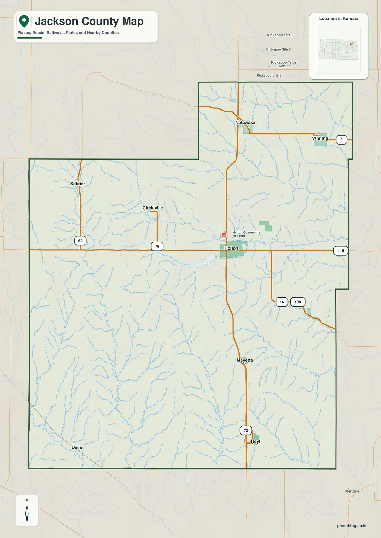
The rural road grid is repeatedly interrupted by creek valleys, especially in the western and southern county. The northeast is also heavily dissected by Delaware River tributaries. This map is intended for county-scale orientation rather than live navigation, so current construction, winter conditions, and unpaved-road status should be checked with up-to-date transportation sources.
Six major communities from Holton to Whiting and Hoyt
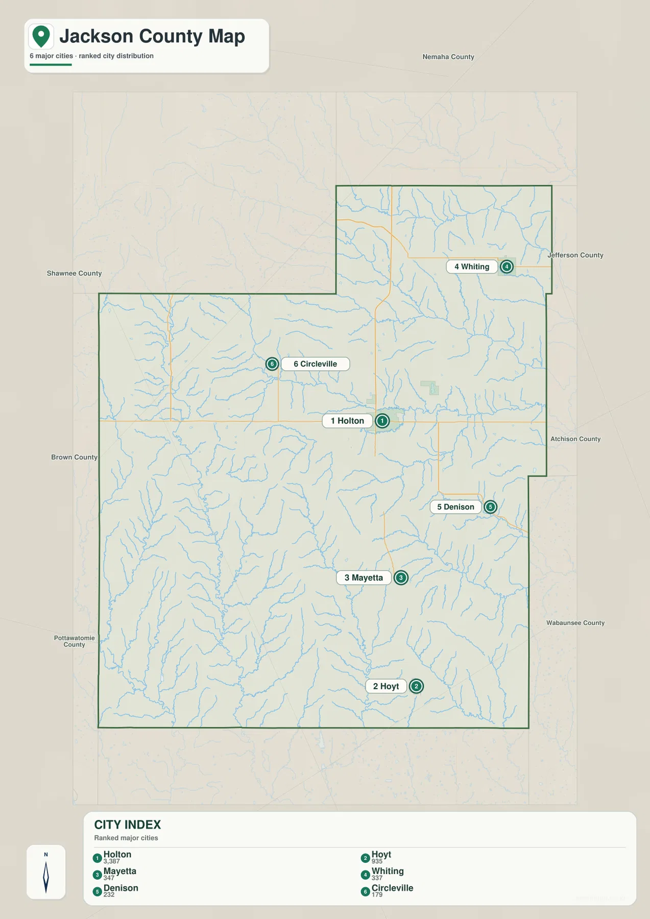
The city distribution map ranks Holton first, followed by Hoyt, Mayetta, Whiting, Denison, and Circleville. The displayed values are 3,387 for Holton, 935 for Hoyt, 347 for Mayetta, 337 for Whiting, 232 for Denison, and 179 for Circleville. Those figures reflect the dataset used to create the map, while the broader settlement pattern remains useful even as population estimates change.
Holton is the administrative and service center. Hoyt and Mayetta organize the southern corridor, Whiting provides a northeastern reference, Circleville identifies the western interior, and Denison helps orient the southeast. Mayetta is also close to the Prairie Band Potawatomi community, so modern municipal geography overlaps with an important Indigenous cultural landscape.
The Kansas Historical Society records that Holton became the county seat in 1858 and has remained in that role. The official Jackson County website also places county government at the courthouse in Holton. The city’s central position and larger population therefore match its long-standing administrative importance.
Soldier Creek, Elk Creek, and the Delaware River lowlands
Soldier Creek is one of the most prominent drainage features on the terrain map. It cuts through the western and south-central county, while Little Soldier Creek forms a separate valley to the east before the two systems continue toward lower country. Cross Creek and Little Cross Creek add more deeply incised channels near the southwest.
East of Holton, Elk Creek creates a long low corridor, and Straight Creek runs roughly parallel farther north. Prairie Lake and Banner Creek Reservoir lie between the central and eastern drainage areas and provide easy map references. Banner Creek Reservoir is also highlighted by the county’s official website as a local recreational water body.
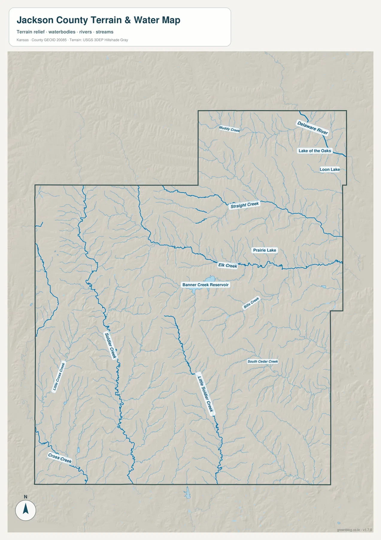
The Delaware River crosses the northeastern portion of the county, with Muddy Creek and smaller tributaries feeding the surrounding lowlands. Lake of the Oaks and Loon Lake are also labeled in this area. The map is a geographic reference rather than a live flood or streamflow product, so current river stage, water quality, or flood conditions should be checked through USGS or responsible local agencies.
A 284–424 meter contrast between western hills and eastern valleys
The elevation map shows an actual county range of approximately 284 to 424 meters and a mean elevation near 342 meters. Brown and orange colors cover much of the west and west-central county, while yellow-green and green become increasingly common toward the east. The pattern reveals a rolling landscape with a noticeable difference between uplands and major drainage corridors.
Soldier Creek cuts a deep north-south valley into the higher western terrain, and Little Soldier Creek adds another low corridor farther east. Elk Creek and Straight Creek broaden into greener eastern lowlands, while the Delaware River occupies some of the lowest terrain in the northeast. Small tributaries create a dense pattern of ridges and hollows between the major valleys.
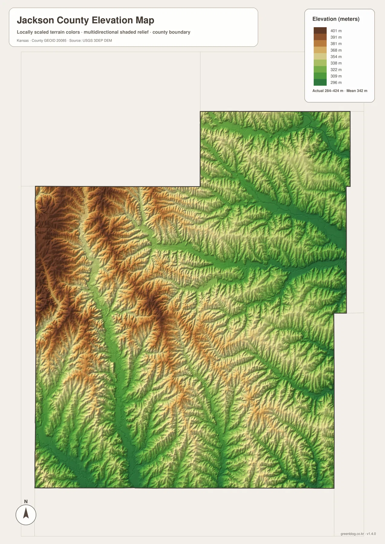
This elevation surface is intended for county-scale comparison rather than survey-grade measurement. It should not be used to establish exact parcel elevations, design drainage, or replace engineering and legal survey data. Its value is visual context: the map makes the western uplands and lower eastern drainage country easy to compare from Holton outward.
From Calhoun County to Jackson County and Holton
Jackson County is one of the older counties created during the Kansas territorial period. The Kansas Historical Society explains that it began as Calhoun County in 1855 and was renamed Jackson County in 1859. After boundary changes, Holton became the county seat in 1858 and has retained that role ever since.
The area also experienced the conflict of Bleeding Kansas. Historical Society records describe the 1858 Battle of Spurs near Holton between free-state and proslavery forces, followed by local support for a free-state constitution. The railroad reached Holton in 1872, giving the county seat a stronger transportation and commercial position.
Those events help explain why Holton remains so prominent on the modern map. Roads, government services, and the largest urban footprint all cluster around a community that has served as the county’s principal center for well over a century.
Prairie Band Potawatomi and older Indigenous geographies
The Kansas Historical Society notes that the Prairie Band Indian Reservation lies in Jackson County and that Delaware, Kickapoo, Potawatomi, and other Indigenous peoples have deep histories in the area. Mayetta is the most useful modern town reference for understanding this cultural geography on the map.
Historical Kickapoo lands also extended through parts of Brown, Jackson, and Atchison counties. An 1857 Kansas Historical Society map of Kickapoo reserve lands shows settlements, roads, rivers, missions, and cultivated areas across that region. It provides a much older layer of geography than the present county-road system.
Natural features such as Soldier Creek and the Delaware River mattered long before modern highways and municipal boundaries. Looking at those valleys alongside present-day towns helps show how the same landscape supported different communities and travel routes across very different periods of Kansas history.
Using the maps for printing, study, and county orientation
For basic road orientation, begin with Holton and follow K-75 south toward Mayetta and Hoyt, then place Circleville, Whiting, and Denison around that hub. For physical geography, trace Soldier Creek through the west and compare it with Elk Creek and the Delaware River in the east and northeast. The elevation map then shows why those river and creek corridors stand out so clearly.
The high-resolution JPG files in the ZIP are better suited than the reduced web previews for printing, classroom projects, local-history materials, and close inspection of labels. They are useful for county overviews and regional comparison, but current roads, live stream conditions, parcel boundaries, and exact elevations should always be checked against the latest authoritative sources when those details matter.
Frequently Asked Questions
Where is Holton on the Jackson County map?
Holton sits slightly east of the county center and serves as the county seat and largest city. K-16, K-75, and K-116 connect through the wider Holton area, making it the easiest first reference for county orientation.
Where are Soldier Creek and the Delaware River?
Soldier Creek runs through the western and south-central county, accompanied by Little Soldier Creek and several smaller tributaries. The Delaware River crosses the northeastern side, where the elevation map also shows some of the county’s lower terrain.
Can the 284–424 meter elevation map be used for surveying?
No. The elevation map is a county-scale visual reference for comparing uplands and drainage valleys. Exact parcel elevations, construction design, drainage engineering, and legal surveys require purpose-built data and professional methods appropriate to those tasks.
Map File Information
Download the high-resolution JPG files corresponding to the Jackson County general, city distribution, terrain-and-water, and elevation maps in one ZIP archive.
- Included Files: Use only the versions confirmed in the article and supplied images
- File Type: Use the confirmed download contents
- Intended Use: Printing, education, presentations, and map-based projects
Related Maps
Sources and references
- Jackson County, Kansas official website — Holton courthouse, Banner Creek Reservoir, and county information
- Kansas Historical Society — Jackson County, Kansas — county seat, Glaciated Region, Prairie Band Reservation, and local history
- Kansas Historical Society — Kickapoo Indian Reserve lands — historical reserve geography extending through Jackson County
- U.S. Census Bureau TIGER/Line — boundary, road, and geographic data resources
- USGS National Hydrography — hydrography and stream-network data information
- USGS 3D Elevation Program — elevation data information
Green Map creates custom-edited map images using open geographic data sources such as geoBoundaries, Natural Earth, OpenStreetMap, and government open data.
These maps are edited visual materials, not raw data files, and are provided for education, documents, presentations, and graphic reference.