Logan County lies in western Kansas, where broad uplands are cut by the Smoky Hill River and a network of smaller creeks. Oakley, the county seat, sits near the northeastern corner, while Winona and Russell Springs are spread well to the west and southwest. Thomas County borders the north, Sherman County is to the northeast, Gove County is east, and Wallace, Wichita, Scott, and Greeley counties frame the western and southern sides.
This page brings together maps for roads and settlements, city connections, waterways, and elevation so the county can be viewed from several practical angles. High-resolution JPG versions are available to download for printing or offline use. The maps are most useful when treated as complementary references: the road map establishes location, the water map isolates stream valleys, and the elevation view explains why those valleys stand out from the surrounding High Plains terrain.
Table of Contents
Oakley anchors the northeastern corner while roads spread across open country
Oakley is the clearest transportation reference on the general county map. Interstate 70 crosses the northern part of Logan County and reaches Oakley near the northeastern edge, while US 40 continues west from the same general area. US 83 runs north and south along the eastern side. Together, those routes make Oakley much easier to place than the smaller communities scattered farther into the county, and they explain why the northeastern corner has a denser road pattern than much of the south.
Winona appears farther west and slightly south of the northern boundary, Monument is positioned between Winona and Oakley, and Russell Springs sits closer to the center-southwest. A route 25 marker is visible in the southwestern part of the map, while numerous numbered local roads form long north-south and east-west lines through the rural interior. The result is a county where a few major highways define the outer travel framework but local access depends on a much wider grid of smaller roads.
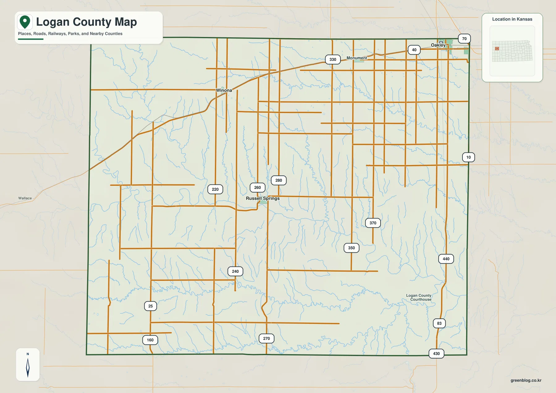
The surrounding county labels provide useful orientation beyond Logan County itself. Thomas County lies directly north, Sherman County is northeast, Gove County is east, and Wallace County is to the west. Scott and Greeley counties help define the southern side. These labels do not replace a statewide route map, but they make it easier to understand where Logan County sits within western Kansas and to compare it with adjacent county map pages.
The city view shows how far Oakley sits from Winona and Russell Springs
The city-connections map removes much of the road detail and focuses on three named communities. Oakley is used as the hub, with Winona shown to the west and Russell Springs to the southwest. The graphic lists a direct distance of about 22 miles from Oakley to Winona and about 23 miles from Oakley to Russell Springs. Those are straight-line distances between the mapped points, not driving mileage, so a road route may be longer and should be checked separately when travel time matters.
This simplified view is especially helpful because Logan County does not have a dense cluster of towns. Oakley occupies a distinct northeastern position, Winona is separated from it across the northern half of the county, and Russell Springs sits farther south. Returning to the general map after seeing those relationships makes the road network easier to interpret: Oakley is tied closely to I-70 and US 83, while Winona and Russell Springs depend more heavily on the interior road grid.
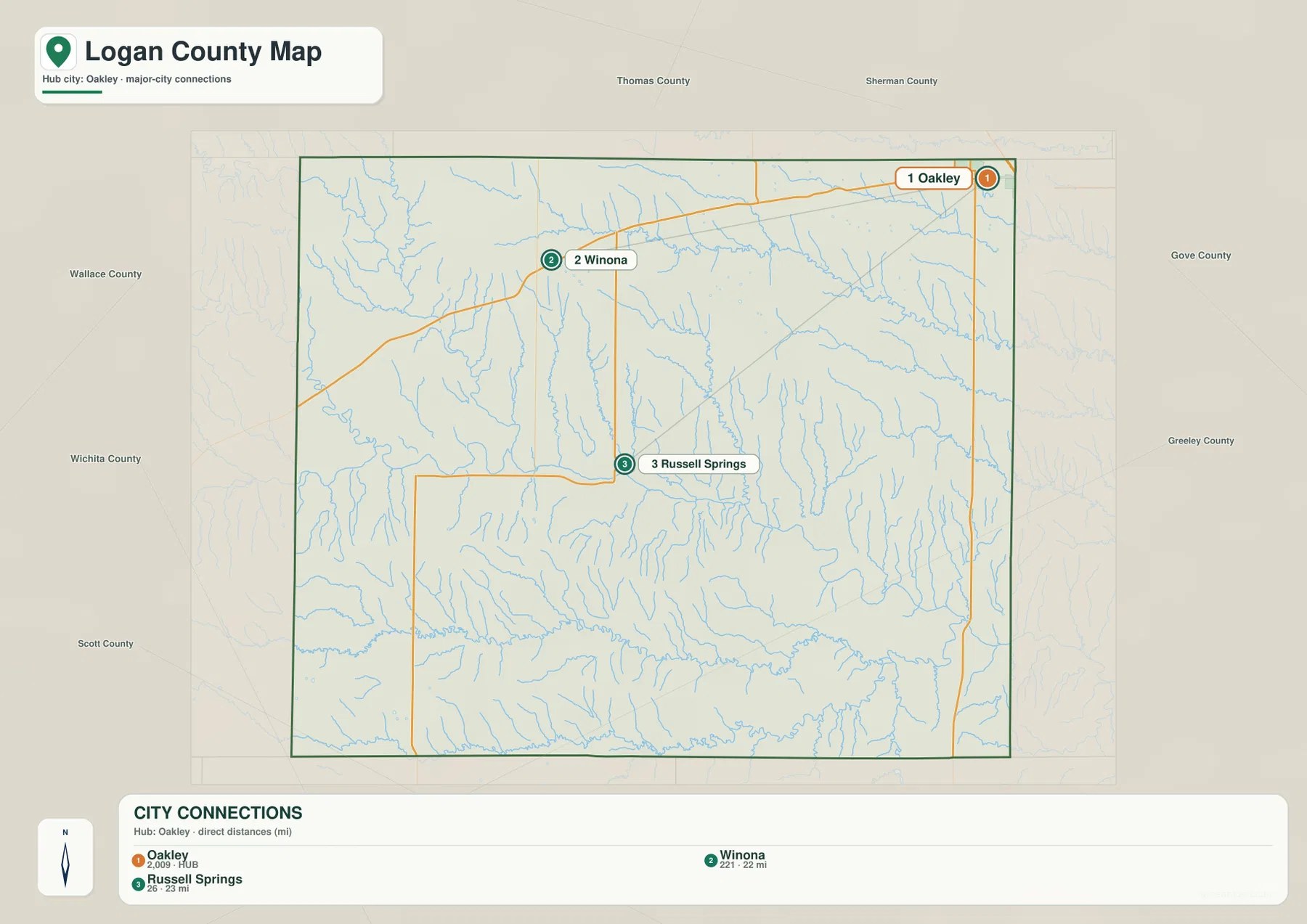
The numeric city labels on this graphic belong to the map dataset and should not be treated as a fresh population estimate. For demographic context, the Kansas Historical Society reports a total Logan County population of 2,762 in the 2020 census and lists Oakley Township as the largest township or independent-city unit in its county table. That official context helps explain why Oakley receives visual emphasis, while the purpose of this map remains geographic rather than statistical.
Smoky Hill River forms the central valley while Hackberry branches drain the north
The terrain-and-water map changes the emphasis completely. The Smoky Hill River enters from the west, bends across the middle of Logan County, and continues toward the east. In the northwest, the North Fork Smoky Hill River feeds toward the main river system. Farther north, Middle Branch Hackberry Creek creates a long drainage line, with North Branch Hackberry Creek and South Branch Hackberry Creek appearing nearby. These named channels make the northern half of the county look much more dissected than the road map alone suggests.
Several smaller waterways add detail across the center and south. Sand Creek drops through the western side, while West Spring Creek and Spring Creek occupy narrower valleys closer to the middle. Twin Butte Creek runs across much of the southern part of the county, and Ladder Creek and Chalk Creek are prominent farther southeast. The map is designed to show where these rivers and creeks lie in relation to the terrain; it is not a flood-hazard map, a live stream-condition map, a property-boundary product, or a navigation chart.
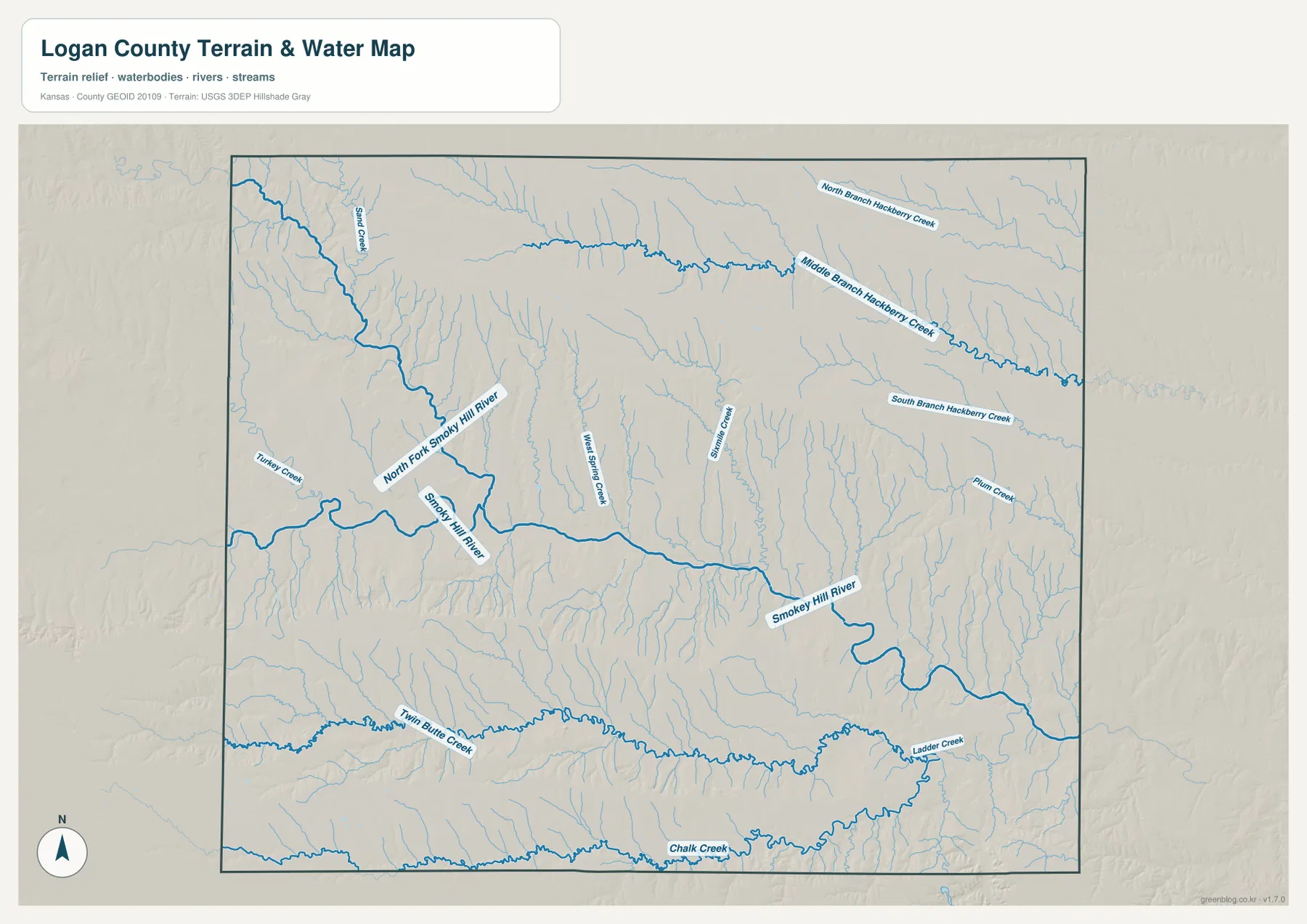
The broader watershed context is supported by Kansas environmental records, which identify the Smoky Hill basin and a Hackberry subbasin within the regional river system. That does not mean every blue line on this map carries water continuously through the year; western Kansas streams can vary greatly by season and local conditions. For this page, the important point is the shape of the drainage network and the way the main river provides a central geographic reference across Logan County.
Elevation drops into the Smoky Hill valley from higher western ground
The elevation map reports an actual range of roughly 795 to 1,062 meters, with a mean near 945 meters. The highest colors cover substantial parts of the west and northwest, and another belt of relatively high ground appears in the southwest. A lower corridor follows the Smoky Hill River through the central part of the county, then broadens toward the east. Smaller tributary valleys branch away from that corridor, producing a clear tree-like pattern that is much harder to see on a standard road map.
Logan County is therefore more varied than the phrase “flat western Kansas” might suggest. The overall landscape belongs to a high-elevation part of the state, but stream erosion has cut distinct valleys into the uplands. The Kansas Historical Society places the county in both the High Plains and Smoky Hills physiographic regions. That regional description fits the map well: broad high surfaces dominate many areas, while the Smoky Hill River and its tributaries create lower, more strongly carved terrain through the middle and east.
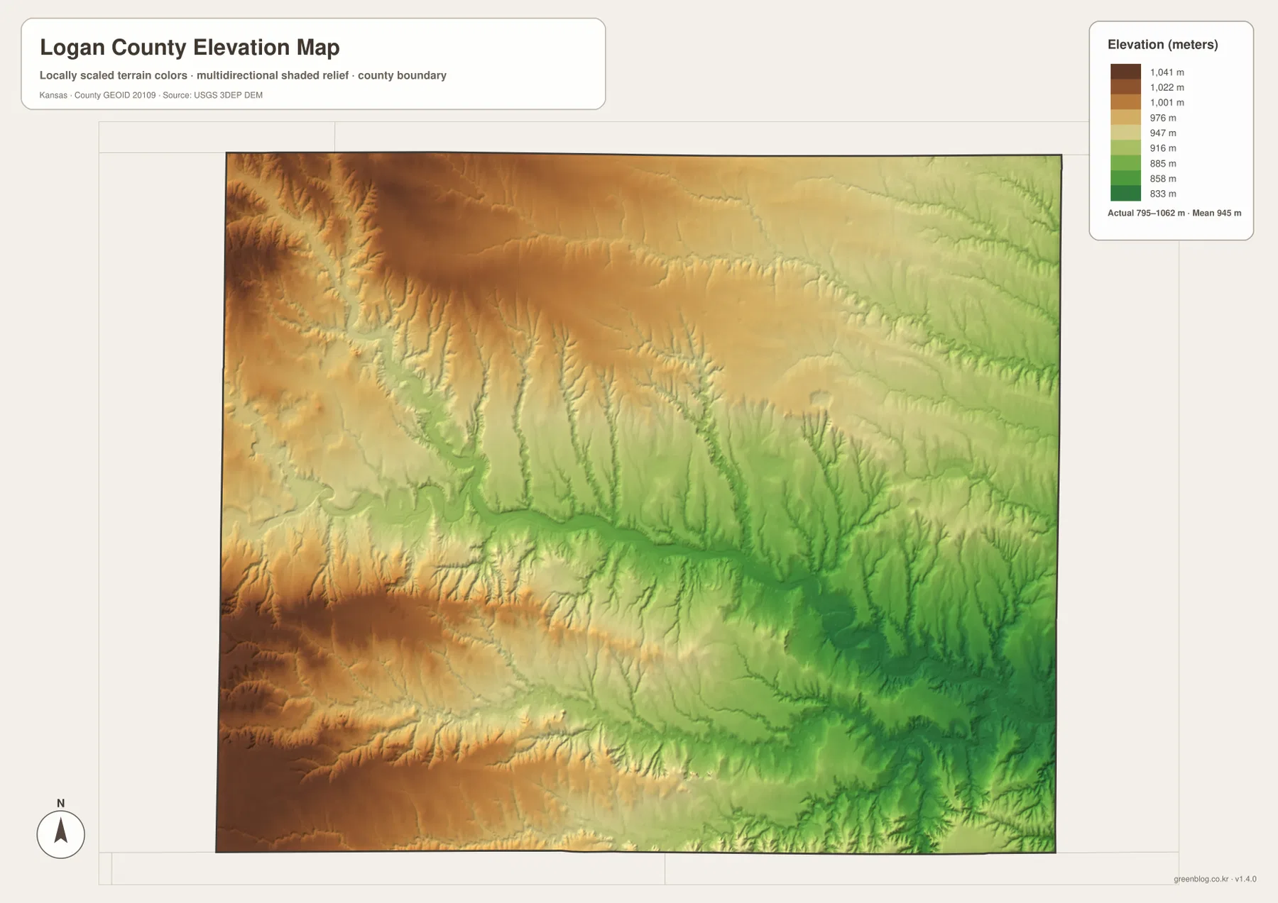
This surface is meant for county-scale terrain orientation rather than precise site measurement. It can show where the land is generally higher or lower and how valleys connect, but it should not be used as survey-grade elevation for a parcel, construction project, drainage design, or engineering calculation. When exact elevation is required, use appropriate survey data or detailed official elevation products. For general map reading, however, it is an effective way to connect the water network with the underlying shape of the land.
Russell Springs adds Butterfield Trail history to the modern map
Russell Springs is small on the modern map, but it has an outsized role in Logan County history. The Kansas Historical Society records that the settlement developed as a stop on the Butterfield Overland Dispatch route in the nineteenth century. It later became the county seat and held that role until 1963, when the seat moved to Oakley after a long political and legal dispute. The former courthouse in Russell Springs later became the Butterfield Trail Museum.
Seeing Russell Springs and Oakley on the same county map gives that history a geographic frame. The two communities are not adjacent; the city map places Russell Springs southwest of Oakley, separated by more than twenty miles in a straight line. Modern roads, township lines, and waterways are not a reconstruction of the old stage route, but they help readers understand the distances involved in a sparsely settled western county. Anyone planning a history-focused visit should use current museum or local-government information for access and opening details.
Choosing a map for roads, waterways, terrain, or printing
Start with the general county map when you need Oakley, Winona, Russell Springs, neighboring counties, and the principal highways in one view. The city map is better when the question is simply how the three main labeled communities are positioned relative to one another. Choose the terrain-and-water map for the Smoky Hill River, Hackberry Creek branches, Twin Butte Creek, and other named drainages. The elevation map is the strongest option for explaining the higher western ground and the lower central river corridor.
The maps also work well in sequence. For example, locate Russell Springs on the city map, find its surrounding road network on the county map, then compare nearby stream valleys on the water map. To explain the Smoky Hill River, start with its named course on the water map and switch to the elevation view to see the low corridor it occupies. Using each map for the information it presents most clearly avoids the clutter that would result from forcing all labels, roads, streams, and terrain colors onto one image.
For a printed handout or large presentation slide, use the original JPG files in the ZIP rather than enlarging the web previews. The higher-resolution files preserve small road labels, creek names, and terrain shading more effectively. Keep the elevation legend visible when terrain height matters, and retain the water-map labels when the discussion depends on individual stream names. Cropping can be useful for a focused presentation, but the map title and key context should remain whenever possible.
Frequently Asked Questions
Which map is best for comparing Oakley, Winona, and Russell Springs?
Use the city-connections map first because it strips away most other details and shows the three communities as a simple geographic comparison. Oakley is the hub, Winona lies to the west, and Russell Springs lies southwest. The listed 22-mile and 23-mile values are straight-line distances from Oakley, not road mileage, so the general county map or a current navigation service is still needed for driving routes.
Where does the Smoky Hill River cross Logan County?
On the terrain-and-water map, the Smoky Hill River enters from the western side and runs across the central part of the county before continuing east. The North Fork Smoky Hill River joins the broader system in the west, while numerous shorter creeks descend toward the central valley. The water map is the clearest file for following these channels by name.
Can the 795–1,062 meter elevation range be used for surveying?
No. The elevation map is a generalized county-scale terrain reference. Its range is useful for comparing broad uplands and valleys, but it does not provide survey-grade values for individual parcels or construction sites. Precise engineering, drainage, or property work requires suitable official elevation data and, when appropriate, a professional survey.
Map File Information
The archive contains the Logan County, Kansas general county map, city-connections map, terrain-and-water map, and elevation map as original high-resolution JPG files for printing or offline use.
- Included Files: Use only the versions confirmed in the article and supplied images
- File Type: Use the confirmed download contents
- Intended Use: Printing, education, presentations, and map-based projects
Related Maps
Sources and references
- Kansas Historical Society: Logan County, Kansas — county formation, Oakley and Russell Springs, 2020 census context, and physiographic region
- City of Oakley: History of Logan County — county-seat history and local background
- U.S. Census Bureau TIGER/Line Shapefiles — county boundary and geographic reference data
- USGS National Hydrography — river and stream reference data
- Kansas Department of Health and Environment: Smoky Hill-Saline River Basin — regional basin and Hackberry subbasin context
- USGS 3D Elevation Program — elevation and terrain reference data
Green Map creates custom-edited map images using open geographic data sources such as geoBoundaries, Natural Earth, OpenStreetMap, and government open data.
These maps are edited visual materials, not raw data files, and are provided for education, documents, presentations, and graphic reference.