Lane County lies in western Kansas, where Dighton is the county seat, the principal road junction, and the only major city shown on the city-distribution map. Healy, Shields, and Alamota provide smaller rural references across a sparsely settled High Plains landscape. K-96 crosses the county east-west through Dighton, K-23 runs north-south, and K-4 serves the northern side. High-resolution JPG versions of the maps shown on this page can be downloaded together from the ZIP box below. High-resolution map files are available for download in the section below.
The water map is organized around several branches of Walnut Creek. North Fork Walnut Creek crosses the north-central county, Middle Walnut Creek and Middle Fork Walnut Creek cut through the central and eastern area, and South Fork Walnut Creek forms a long southern valley. Wild Horse Creek, Cheyenne Creek, West Salt Creek, Spring Creek, and Hackberry Creek add deeper drainage corridors. Elevation ranges from about 742 to 898 meters with a mean near 842 meters.
The Kansas Historical Society records that Lane County was established in 1873 and organized in 1886, with Dighton serving as the county seat. The county spans the High Plains and Smoky Hills physiographic regions and has experienced cattle drives, severe western Kansas settlement difficulties, the Dust Bowl, and oil development beginning in the twentieth century. The modern map still reflects that rural history through its single dominant town and broad agricultural landscape.
Table of Contents
Dighton marks the crossing of K-96 and K-23
Dighton sits close to the center of Lane County and is the easiest place to begin on the general map. K-96 runs from the Scott County side through Dighton toward Ness County, while K-23 approaches from Finney County to the south and continues toward Gove County. Their intersection falls in Dighton, combining the county-seat role with the most important road junction.
North of Dighton, K-23 meets K-4. K-4 crosses the northern county and helps connect the Healy and Shields areas. Healy is the strongest northwest place reference, Shields appears in the north-central area, and Alamota provides an eastern rural reference. In a county with very few incorporated places, these smaller labels are especially useful for orientation.
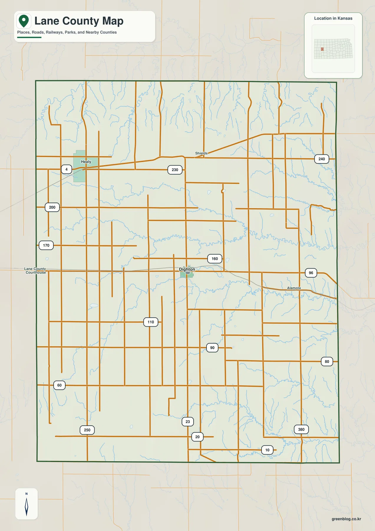
The western road grid is comparatively open and regular, but the eastern side is much more strongly dissected by creeks. Roads bend, stop, or cross numerous small valleys, especially in the northeast and southeast. The map is designed for county-scale orientation rather than live navigation, so current construction, unpaved-road conditions, wind, and winter weather should be checked separately.
Dighton stands alone as the major city
The city-distribution map contains only one ranked major city: Dighton. The source used for the map shows a value of 733 for Dighton. Population figures vary by dataset and date, but the geographic pattern is clear—the county’s urban functions, government, and major road intersection are concentrated in a single community.
Healy, Shields, and Alamota appear on the general map as rural place references but are not ranked as major cities on the city map. That makes Lane County very different from counties with several competing town centers. It is better understood as one administrative and service center surrounded by a very large rural hinterland.
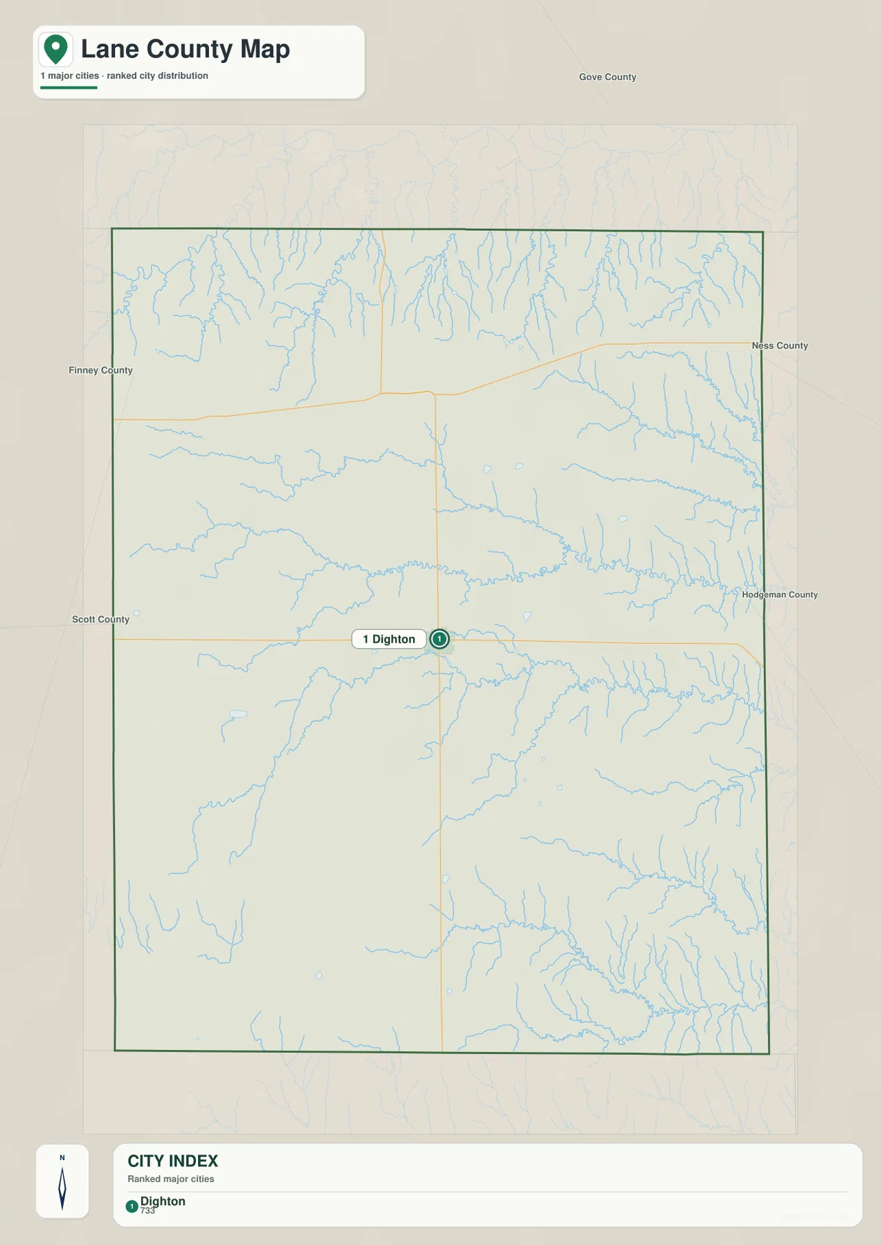
Kansas Historical Society data list Lane County’s 2020 population at 1,574 and identify Dighton as the county seat. The empty-looking spaces on the city map still contain farms, ranches, roads, and small rural communities, so the map should be read as a settlement hierarchy rather than a complete inventory of inhabited places.
Walnut Creek forks shape the central and eastern county
The water and terrain map is dominated by branches of Walnut Creek. North Fork Walnut Creek crosses the north-central county and continues toward the eastern edge. Middle Walnut Creek and Middle Fork Walnut Creek form separate central valleys, while South Fork Walnut Creek creates another long drainage farther south.
Lane County State Lake lies near the North Fork system and provides an easy local reference. Cottonwood Creek joins the northeastern drainage network, and Wild Horse Creek cuts through deeply dissected country near the eastern side. These creek valleys are also visible on the elevation map as narrow green corridors below the surrounding uplands.
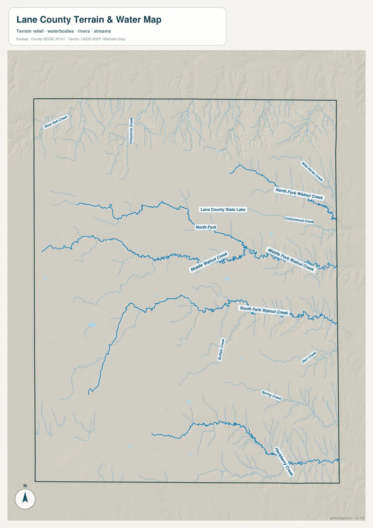
West Salt Creek and Cheyenne Creek dissect the northwestern uplands. Spring Creek, Hackberry Creek, and Darr Creek create lower valleys in the southeast, while Buffalo Creek appears near the South Fork Walnut Creek area. The map shows geographic position and terrain relationships rather than live streamflow, flood risk, or water quality.
Elevation falls from 898-meter western uplands toward 742-meter eastern valleys
Lane County ranges from approximately 742 to 898 meters in elevation and averages near 842 meters. The highest brown and orange terrain covers much of the west and southwest. Moving east, the colors shift through tan and yellow-green into broad areas of green, revealing a strong overall decline toward the eastern county.
Northern and northeastern tributaries cut long finger-like valleys into the high surface. The Walnut Creek forks create lower corridors through the center and east, while the Hackberry Creek system produces especially deep and closely spaced valleys in the southeast. The shaded relief shows that eastern Lane County is far more dissected than the broad western uplands.
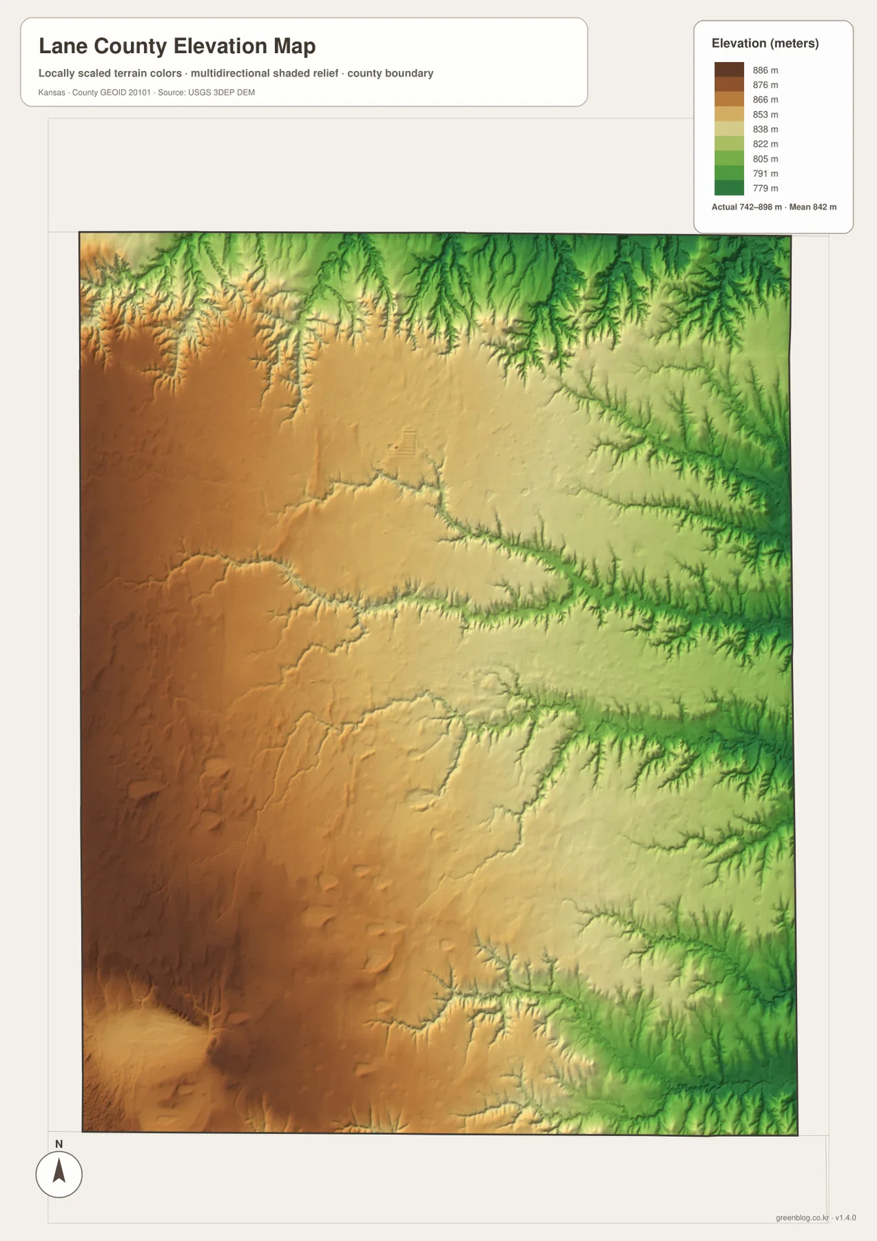
This elevation surface is intended for county-scale comparison rather than survey-grade measurement. It should not be used to establish exact parcel elevations, design drainage, or replace engineering and legal survey data. Its main value is showing the broad west-to-east decline and the strong local relief along eastern stream valleys.
Dighton became the county seat in 1886
Lane County was established in 1873 and formally organized in 1886. The Kansas Historical Society identifies Dighton as the county seat and explains that the county was named for James Henry Lane, a prominent territorial Kansas free-state leader and one of the state’s first U.S. senators.
Dighton’s name has an unusual spelling story. National Register documentation states that the settlement originally used the name Deighton, but an ‘e’ was omitted in the report associated with the 1886 county-seat declaration. The shortened spelling became permanent. The first courthouse was built that year, while the present courthouse dates to 1930–1931.
Rail service reached Dighton in 1887, strengthening the town’s commercial and service role. The modern map still shows the same concentration of functions: county government, the largest settlement, and the K-96/K-23 junction all occupy the same central location.
Cattle drives, Dust Bowl years, and oil shaped the county economy
Kansas Historical Society accounts describe Lane County as part of the western Kansas cattle-drive landscape, with Texas Longhorn herds passing through the area. The broad High Plains provided open country, but settlement and farming were difficult because of dry conditions and the large acreage needed for reliable agriculture.
The early 1890s were especially difficult for Lane County residents, and the Dust Bowl brought another major environmental crisis during the 1930s. Dust storms and drought affected farming throughout western Kansas. Those experiences help explain the county’s long history of sparse settlement and large agricultural holdings.
Oil was discovered in the county in the 1950s, adding another important economic activity alongside farming and livestock. The map does not show individual oil facilities, but this history is useful context because Lane County’s rural economy has never depended on a single activity.
Using the maps for printing, study, and county orientation
For road orientation, start with Dighton and use K-96 as the east-west reference and K-23 as the north-south reference. For physical geography, trace the North, Middle, and South Forks of Walnut Creek, then compare Wild Horse Creek in the northeast and Hackberry Creek in the southeast. The elevation map explains why these eastern drainages are so deeply cut.
The high-resolution JPG files in the ZIP are better suited than the reduced web previews for printing, classroom projects, county-history study, and close inspection of road and water labels. Current road conditions, live stream information, parcel boundaries, and exact elevations should always be checked against the latest authoritative sources when those details matter.
Frequently Asked Questions
Where is Dighton on the Lane County map?
Dighton sits close to the center of the county and serves as the county seat and only ranked major city on the city map. K-96 runs east-west through the city, while K-23 provides the main north-south route.
Where are the main Walnut Creek branches?
North Fork Walnut Creek crosses the north-central county, Middle Walnut Creek and Middle Fork Walnut Creek cut through the central and eastern area, and South Fork Walnut Creek forms a long southern valley. Several tributaries join these lower corridors.
Can the 742–898 meter elevation map be used for surveying?
No. The elevation map is a county-scale visual reference for comparing uplands and creek valleys. Exact parcel elevations, construction design, drainage engineering, and legal surveys require purpose-built data and professional methods.
Map File Information
Download the high-resolution JPG files corresponding to the Lane County general, city distribution, terrain-and-water, and elevation maps in one ZIP archive.
- Included Files: Use only the versions confirmed in the article and supplied images
- File Type: Use the confirmed download contents
- Intended Use: Printing, education, presentations, and map-based projects
Related Maps
Sources and references
- Kansas Historical Society — Lane County, Kansas — Dighton, county-seat history, High Plains and Smoky Hills, Dust Bowl, and oil development
- Kansas Historical Society — Lane County profile — establishment, organization, county seat, and 2020 population
- Lane County Historical Society & Museum — local history resources in Dighton
- U.S. Census Bureau TIGER/Line — boundary, road, and geographic data resources
- USGS National Hydrography — hydrography and stream-network data information
- USGS 3D Elevation Program — elevation data information
Green Map creates custom-edited map images using open geographic data sources such as geoBoundaries, Natural Earth, OpenStreetMap, and government open data.
These maps are edited visual materials, not raw data files, and are provided for education, documents, presentations, and graphic reference.