Kingman County lies in south-central Kansas, where the city of Kingman provides the clearest starting point for understanding roads, settlement, river valleys, and the strong west-to-east change in elevation. Kingman is the county seat and largest city, followed by Norwich and Cunningham. Spivey, Zenda, and Nashville form a smaller southern settlement group. U.S. 54 and U.S. 400 cross the county through Kingman, while K-14 and the southern K-42 corridor add north-south and east-west connections. High-resolution JPG versions of the maps are available together in the ZIP box below. High-resolution map files are available for download in the section below.
The county’s physical geography is organized around two major drainage systems. The South Fork Ninnescah River crosses the northern and central county, while the North Fork Chikaskia River and Chikaskia River cut across the south. State Lake and Christopher Lake provide additional water references. Elevation ranges from about 404 to 555 meters with a mean near 481 meters, showing higher western and southwestern uplands and much lower terrain toward the east.
The Kansas Historical Society records that Kingman County was organized in 1874 and that Kingman became the permanent county seat after an 1881 election. Railroads arrived in the 1880s, followed by salt production, oil and gas development, and other industries. Those historical connections help explain why the city of Kingman remains the strongest transportation and administrative center on the modern map.
Table of Contents
Kingman sits at the county’s main highway junction
Kingman lies close to the north-central part of the county and is the easiest place to begin on the general map. U.S. 54 and U.S. 400 run east-west through the city, connecting Cunningham on the west with the Sedgwick County side to the east. K-14 crosses the same area north-south and continues into the southern rural half.
Cunningham anchors the western U.S. 54/400 corridor, while Norwich is the largest community in the southeast. Spivey, Zenda, and Nashville lie along the southern road network and provide useful references across an otherwise sparsely settled agricultural landscape. Once Kingman and the two principal highway directions are located, the county road pattern becomes much easier to follow.
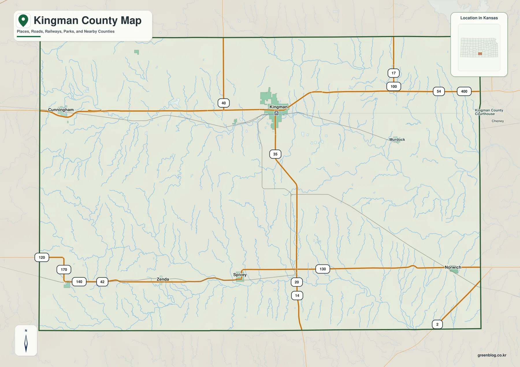
Most rural roads follow a regular grid, but river and creek valleys repeatedly interrupt that pattern. This is especially noticeable around the South Fork Ninnescah River and the Chikaskia drainage systems, where crossings and slopes shape local access. The map is designed for county-scale orientation rather than live navigation, so current construction, unpaved-road conditions, high winds, and winter weather should be checked separately.
Kingman dominates a small six-city settlement pattern
The city distribution map ranks Kingman first, Norwich second, Cunningham third, Spivey fourth, Zenda fifth, and Nashville sixth. The displayed values are 2,957 for Kingman, 437 for Norwich, 414 for Cunningham, 115 for Spivey, 86 for Zenda, and 57 for Nashville. These figures reflect the source used for the map and may differ from later estimates.
The pattern is highly centralized. Kingman concentrates county government, commerce, and major road connections, while Norwich and Cunningham provide secondary centers in the southeast and west. The three smaller southern towns help orient a broad rural area where farms and creek valleys occupy far more space than urban development.
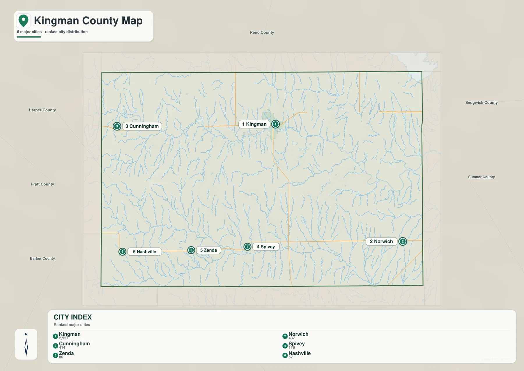
The Kansas Historical Society notes that Kingman was initially a temporary county seat and was confirmed by voters in 1881. Rail service and later industrial development reinforced that central role, leaving a settlement pattern in which one city is much more prominent than the rest.
The South Fork Ninnescah River crosses the northern half
The South Fork Ninnescah River is the strongest water feature in the northern and central county. It enters from the west, bends across the county, and continues toward lower eastern terrain. State Lake lies near this drainage, while smaller creeks descend from the surrounding uplands.
The southern county belongs to a different drainage system. The North Fork Chikaskia River crosses the southwest and south-central area, while the Chikaskia River forms another major low corridor farther south. Allen Creek, Goose Creek, Wild Horse Creek, Red Creek, and other tributaries divide the southern uplands into a dense pattern of ridges and valleys.
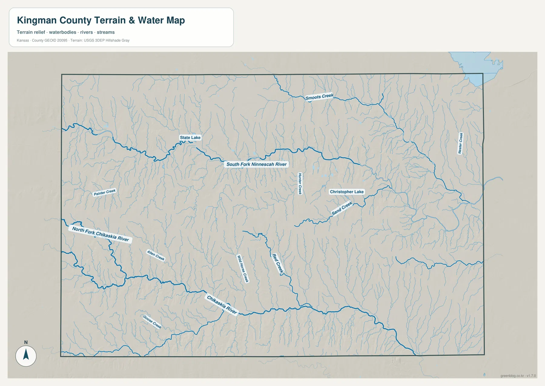
Christopher Lake appears in the east-central county near Sand Creek and provides another useful water reference. Smaller tributaries become especially dense toward the east, where the land is lower and more heavily dissected. The map shows geographic position rather than current streamflow, flood risk, or water quality, so live conditions should be checked through USGS or responsible local agencies.
Elevation falls from 555-meter western uplands toward the east
Kingman County ranges from approximately 404 to 555 meters in elevation and averages near 481 meters. Brown and orange colors dominate much of the west and southwest, while yellow-green and green spread across the east. The county therefore has a very clear west-to-east decline in height.
The South Fork Ninnescah River cuts a broad low valley through the northern uplands, and the Chikaskia systems carve similarly deep corridors across the south. Eastern tributaries are closely spaced and create a finer pattern of ridges and hollows. The county is not mountainous, but the shaded elevation surface shows far more relief than the straight rural roads might suggest.
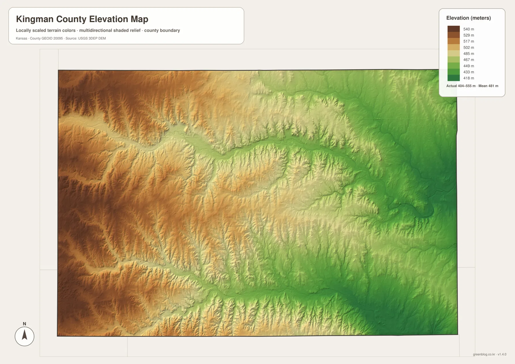
This surface is intended for county-scale comparison rather than survey-grade measurement. It should not be used to establish exact parcel elevations, design drainage, or replace engineering and legal survey data. Its main value is showing the broad decline from the Cunningham side toward Norwich and the lower eastern drainage country.
Railroads, salt, oil, and gas changed the county economy
Kingman County was organized in 1874, and settlement increased rapidly later in that decade. According to the Kansas Historical Society, the railroad reached Kingman in 1884, and additional Santa Fe and Missouri Pacific lines spread through the county by the end of the decade. These connections made it easier to move farm products, people, and manufactured goods.
Salt was discovered in 1887, and evaporation plants followed in 1888. Oil discoveries beginning in 1926 added another important industry, and oil and natural gas became major sources of local income. A helium plant also operated near Cunningham for a time.
These industries make Kingman County different from a simple farming story. Agriculture remained important, but rail transportation and subsurface resources added new reasons for people and businesses to concentrate around Kingman and the major east-west corridor.
Clyde Cessna links the county to Kansas aviation history
The Kansas Historical Society lists Clyde Cessna among notable people connected with Kingman County. Cessna went on to found the Cessna Aircraft Company and became one of the important figures in the rise of Wichita as a major American aircraft-manufacturing center.
Sedgwick County and Wichita lie directly east of Kingman County, so the regional connection is easy to understand on a broader Kansas map. The same south-central Kansas transportation network that served farms, railroads, salt, oil, and gas later helped support a much larger industrial economy centered around Wichita.
That history provides useful context for the modern map. Kingman County remains predominantly rural, but its location on U.S. 54/400 and its long connection with nearby Wichita keep it tied to a much larger regional economy.
Using the maps for printing, study, and county orientation
For road orientation, begin with Kingman and follow U.S. 54/U.S. 400 toward Cunningham and the eastern county, then use K-14 to connect the northern and southern halves. For physical geography, trace the South Fork Ninnescah River across the north and compare it with the North Fork Chikaskia and Chikaskia River valleys in the south.
The high-resolution JPG files in the ZIP are better suited than the reduced web previews for printing, classroom projects, local-history study, and close inspection of road and water labels. Current road conditions, live stream information, parcel boundaries, and exact elevations should always be checked against the latest authoritative sources when those details matter.
Frequently Asked Questions
Where is the city of Kingman on the county map?
Kingman sits close to the north-central part of the county and serves as the county seat and largest city. U.S. 54 and U.S. 400 run east-west through the area, while K-14 provides the main north-south reference.
What are the major river systems in Kingman County?
The South Fork Ninnescah River crosses the northern and central county, while the North Fork Chikaskia River and Chikaskia River form major valleys across the south. These systems divide the county into several distinct upland and lowland areas.
Can the 404–555 meter elevation map be used for surveying?
No. The elevation map is a county-scale visual reference for comparing uplands and river valleys. Exact parcel elevations, construction design, drainage engineering, and legal surveys require purpose-built data and professional methods.
Map File Information
Download the high-resolution JPG files corresponding to the Kingman County general, city distribution, terrain-and-water, and elevation maps in one ZIP archive.
- Included Files: Use only the versions confirmed in the article and supplied images
- File Type: Use the confirmed download contents
- Intended Use: Printing, education, presentations, and map-based projects
Related Maps
Sources and references
- Kingman County, Kansas official website — county government and Kingman administrative information
- Kansas Historical Society — Kingman County, Kansas — county-seat history, railroads, salt, oil, gas, and Clyde Cessna
- Kansas Historical Society — Kingman County profile — county seat, establishment, and 2020 population context
- U.S. Census Bureau TIGER/Line — boundary, road, and geographic data resources
- USGS National Hydrography — hydrography and stream-network data information
- USGS 3D Elevation Program — elevation data information
Green Map creates custom-edited map images using open geographic data sources such as geoBoundaries, Natural Earth, OpenStreetMap, and government open data.
These maps are edited visual materials, not raw data files, and are provided for education, documents, presentations, and graphic reference.