Finney County lies in southwestern Kansas, where Garden City provides the clearest starting point for understanding settlements, highways, irrigation, rivers, and High Plains relief. Garden City is the county seat, Holcomb sits immediately to the west, U.S. 50 and U.S. 400 run east and west through the urban area, and U.S. 83 provides the main north-south reference. The map files shown on this page are also available as high-resolution JPG downloads in a single ZIP archive.
The county contains two very different river settings. The Arkansas River passes south of Garden City through the western and southern portion, accompanied by irrigation features such as the Great Eastern Ditch and Farmers Ditch. Far to the northeast, the Pawnee River and Cottonwood Creek occupy a much more deeply dissected landscape with many branching tributaries. The elevation surface ranges from about 739 to 942 meters with a mean near 865 meters.
The Kansas Historical Society describes Finney County as part of southwestern Kansas and connects its history closely with water availability, irrigation, agriculture, and the Arkansas River Lowlands. That description fits the supplied maps well. Higher, smoother surfaces dominate much of the west and southwest, while the northeastern river country drops into lower, closely spaced valleys. Garden City sits between those landscapes as the county’s main population and transportation center.
Table of Contents
Garden City and Holcomb along U.S. 50 and U.S. 400
Garden City is the most prominent place on the general county map. U.S. 50 and U.S. 400 run through the area from west to east, and U.S. 83 crosses the city on a north-south line. Holcomb lies just to the west, so the two communities form a compact urban cluster within a county that otherwise contains broad rural spaces. The Finney County Emergency Medical label provides another easy landmark inside Garden City.
Deerfield appears beyond the western boundary, while Pierceville is southeast of Garden City. Kalvesta provides a northeastern reference near the K-156 corridor, with K-23 extending through the eastern side of the county. Finney County’s boundary is irregular rather than rectangular, and the long northeastern section makes the distance from Garden City to the Pawnee River country visually striking.
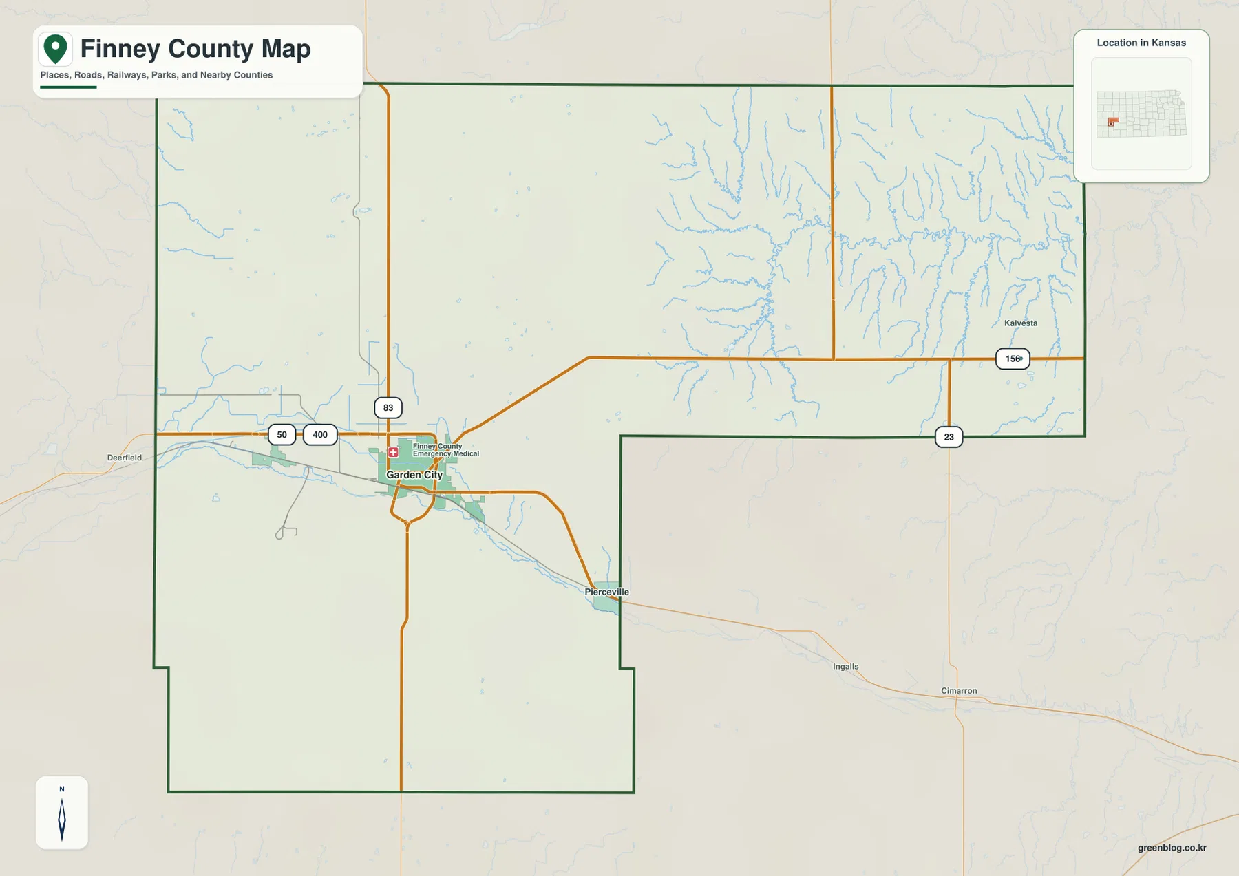
Road density is greatest around Garden City and Holcomb, while the northeastern and southern areas contain longer rural routes and more obvious drainage features. In the northeast, roads cross many tributary valleys feeding the Pawnee River. South of Garden City, the Arkansas River forms a different kind of low corridor. This is a county-scale orientation map rather than a live navigation product, so current closures, construction, weather, and road conditions should be checked separately.
Garden City and Holcomb as the county’s two principal cities
The city distribution map simplifies Finney County to its two major urban references. Garden City is ranked first and occupies the largest continuous urban area, while Holcomb ranks second and lies immediately west of Garden City. Their close spacing makes them more useful as one shared orientation zone than as distant towns at opposite ends of the county.
The ranking is intended as a quick city index rather than a permanent population statement, because population figures depend on the census or estimate used. Geographically, the more important point is that Garden City functions as the county seat and primary service center, while Holcomb shares the same U.S. 50/U.S. 400 corridor and sits close to the Arkansas River and irrigation landscape.
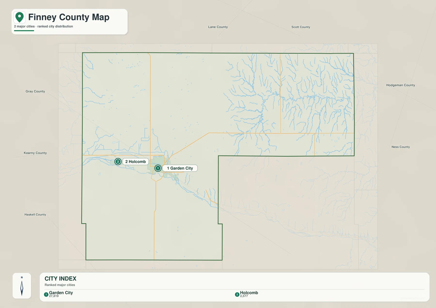
The Kansas Historical Society identifies Garden City as the county seat, and the current Finney County government is also based there. For someone unfamiliar with the region, locating Garden City and Holcomb first makes the rest of the map easier to understand. From that urban anchor, the viewer can follow highways toward Kalvesta or shift to the water and elevation maps to compare the Arkansas River and Pawnee River landscapes.
Arkansas River irrigation around Garden City
The terrain and water map shows the Arkansas River entering from the west and passing south of the Garden City area before continuing southeast. Several mapped irrigation features follow the river corridor or nearby farmland. The Great Eastern Ditch and Farmers Ditch are especially visible west and northwest of Garden City, showing how engineered water routes became part of the local landscape.
The Kansas Historical Society emphasizes the importance of water and irrigation in Finney County’s development. In a semi-arid region, settlers and farmers experimented with irrigation systems that expanded agricultural possibilities and helped Garden City grow. The Great Eastern Ditch is part of that history, so its appearance on the modern water map is more than a minor label; it connects present-day geography with the county’s long adaptation to limited water.
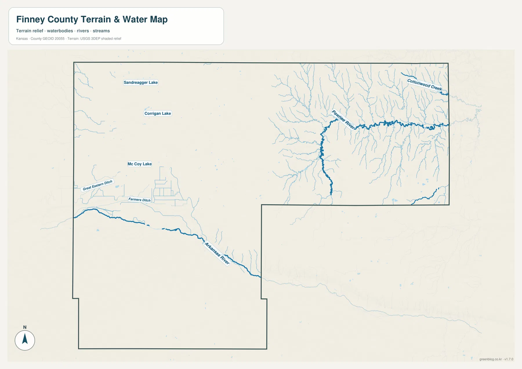
Small lakes are also labeled in the western half, including Sandreagger Lake, Corrigan Lake, and Mc Coy Lake. These features are much smaller than the county’s main river systems but provide useful local references. The water map is not a live source for river stage, flood risk, irrigation delivery, or water quality, so current conditions should be checked with USGS, local water managers, or other responsible agencies.
Pawnee River valleys in northeastern Finney County
Northeastern Finney County looks very different from the Garden City area. The Pawnee River crosses this long extension of the county, and numerous short tributaries descend toward it from both sides. Cottonwood Creek appears near the northeastern edge. The shaded terrain is densely cut by these valleys, creating one of the most visually distinctive parts of the map.
The Arkansas River corridor in the west and south is broader and more open. Although the main channel creates a clear low route, the surrounding landscape has fewer closely packed tributary ravines than the Pawnee River country. This contrast is important because Finney County cannot be described as one uniform flat plain. Different drainage systems have shaped different parts of the county in noticeably different ways.
The Kansas Historical Society places the county within the Arkansas River Lowlands context and notes the Arkansas River’s importance to travel, farming, and irrigation. The northeastern Pawnee River drainage adds another geographic layer that is easy to miss on a simple road map. Comparing both river systems gives a better sense of the county’s internal variety.
From 942-meter western uplands to 739-meter river valleys
The elevation map shows an actual county range of approximately 739 to 942 meters and a mean elevation near 865 meters. Brown and orange colors dominate much of the west and southwest, representing the highest broad surfaces. Garden City occupies an intermediate part of that gradient, while greener terrain becomes increasingly common toward the northeastern river system.
The Pawnee River valley and its tributaries form narrow low corridors that cut deeply into the northeastern uplands. In the west, the Arkansas River also creates a lower band through higher surrounding terrain, but the valley pattern is broader and less densely branched. The southwest retains extensive high ground, and the overall surface generally lowers toward the northeast.
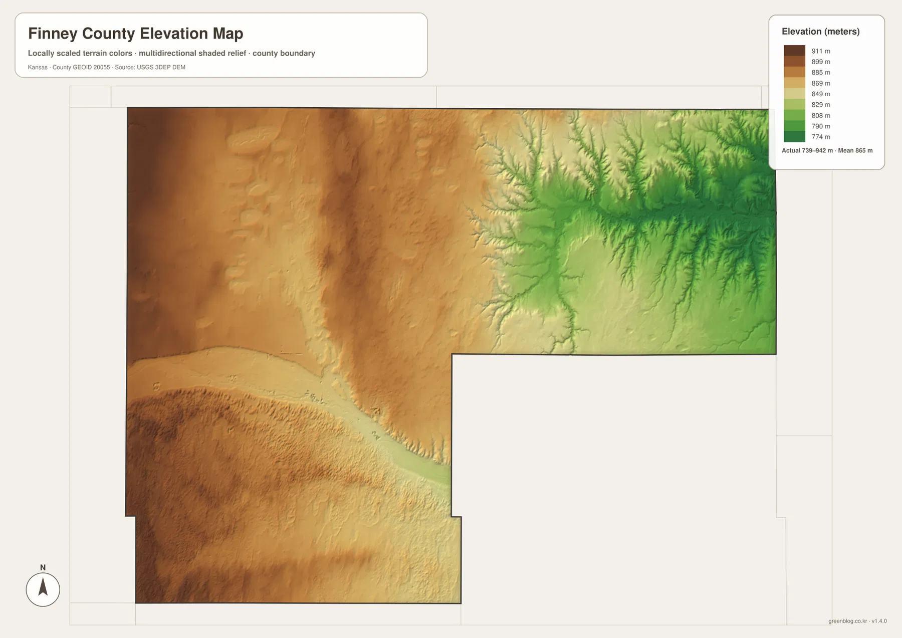
This elevation surface is intended for county-scale comparison rather than survey-grade measurement. It should not be used to establish exact parcel elevations, design drainage, or replace engineering and legal survey data. Its value is visual context: the map makes it easy to compare the higher plains west of Garden City with the Arkansas River corridor and the lower, more dissected northeastern valleys.
Water, agriculture, and the growth of Garden City
The Kansas Historical Society describes Finney County’s history as closely tied to water. Travelers on the Santa Fe Trail considered water availability, later farmers developed irrigation systems, and agricultural industries adapted to the county’s semi-arid climate. Those themes are visible in the map set through the Arkansas River, irrigation ditches, reservoirs, and the concentration of settlement around Garden City.
Garden City developed as the dominant local center through transportation, agriculture, cattle feeding, and food processing. The Historical Society notes that feed yards and meatpacking later attracted workers from many backgrounds, helping shape the city’s modern growth. The maps do not attempt to show the full industrial economy, but the city distribution view makes Garden City’s dominant role within Finney County immediately apparent.
The county’s geography also explains why a single description such as “flat western Kansas” is not sufficient. Broad high surfaces dominate much of the west and south, irrigation features cluster near the Arkansas River, and the northeastern extension is deeply dissected by the Pawnee River system. Taken together, the settlement, water, and elevation views reveal several distinct landscapes within one county boundary.
Using the maps for study, printing, and orientation
For basic orientation, begin with Garden City and Holcomb and then follow U.S. 50/U.S. 400 and U.S. 83. For water geography, compare the Arkansas River and irrigation ditches around Garden City with the Pawnee River and Cottonwood Creek in the northeast. The elevation view then explains why those river settings look so different and shows the broad west-to-northeast change in relief.
The high-resolution JPG files in the ZIP are better suited than reduced web previews for printing, classroom projects, local-history materials, and close inspection of labels. They are useful for county overviews and regional comparison, but current roads, live stream conditions, parcel boundaries, irrigation operations, and exact elevations should always be checked against the latest authoritative sources when those details matter.
Frequently Asked Questions
Where are Garden City and Holcomb on the map?
Garden City is in the western-central part of Finney County and serves as the county seat. Holcomb sits immediately west along the same U.S. 50 and U.S. 400 corridor. Because U.S. 83 also crosses Garden City, the Garden City–Holcomb area is the easiest place to begin orienting the county.
Do the Arkansas River and Pawnee River cross the same part of Finney County?
No. The Arkansas River passes south of Garden City through the western and southern portion of the county. The Pawnee River crosses the long northeastern section, where many short tributaries create a much more densely dissected landscape.
Can the 739–942 meter elevation map be used for surveying?
No. The elevation map is a county-scale visual reference for comparing high plains and river valleys. Exact parcel elevations, construction design, drainage engineering, and legal surveys require purpose-built data and professional methods appropriate to those tasks.
Map File Information
Download the high-resolution JPG files corresponding to the Finney County general, city distribution, terrain-and-water, and elevation maps in one ZIP archive.
- Included Files: Use only the versions confirmed in the article and supplied images
- File Type: Use the confirmed download contents
- Intended Use: Printing, education, presentations, and map-based projects
Related Maps
Sources and references
- Finney County, Kansas official website — county government and local information
- Kansas Historical Society — Finney County, Kansas — Garden City, Arkansas River Lowlands, irrigation, and regional history
- U.S. Census Bureau TIGER/Line — boundary, road, and geographic data resources
- USGS National Hydrography — hydrography and stream-network data information
- USGS 3D Elevation Program — elevation data information
Green Map creates custom-edited map images using open geographic data sources such as geoBoundaries, Natural Earth, OpenStreetMap, and government open data.
These maps are edited visual materials, not raw data files, and are provided for education, documents, presentations, and graphic reference.