Ellsworth County in north-central Kansas is easiest to understand by starting with the city of Ellsworth and the Smoky Hill River valley. Ellsworth is the county seat, Kanopolis sits only a few miles to the southeast, Wilson is near the northwest edge, and Holyrood and Lorraine provide useful references in the southwest. This page explains the roads, settlement pattern, water features, and relief visible in the supplied maps, and matching high-resolution JPG files can be downloaded together from the ZIP box below. High-resolution map files are available for download in the section below.
The Smoky Hill River is the county’s strongest natural landmark. It enters from the west, bends past the Ellsworth area, and continues into Kanopolis Lake in the east. Buffalo Creek, Oak Creek, Spring Creek, Thompson Creek, and many smaller tributaries cut through the surrounding hills. The elevation surface ranges from about 426 to 593 meters with a mean near 508 meters, producing a strong contrast between the river-and-lake lowlands and the higher southwestern and northwestern uplands.
The Kansas Historical Society places Ellsworth County in the Smoky Hills and connects the area with both the cattle-town history of Ellsworth and the Fort Harker story at present-day Kanopolis. Those historical themes fit the map well because the two communities sit close together beside the main river corridor. Reading the settlement map together with the water and elevation views gives a much clearer picture of the county than treating its towns and landforms separately.
Table of Contents
Ellsworth and Kanopolis at the center of the county
Ellsworth is the most useful first reference on the general map. K-140 runs east and west through the central area, K-14 continues south, and routes leading north connect toward U.S. 40 and I-70. Kanopolis lies immediately southeast of Ellsworth, so the two communities form a compact central pair within a county that otherwise contains large rural spaces.
Wilson sits near the northwestern boundary and is reached by the K-232 corridor, while Holyrood is a southwestern community near K-156. Lorraine lies farther east in the southern part of the county. Instead of memorizing isolated compass directions, it is easier to view the county as a central Ellsworth–Kanopolis area, a northwestern Wilson corner, and a southwestern group anchored by Holyrood and Lorraine.
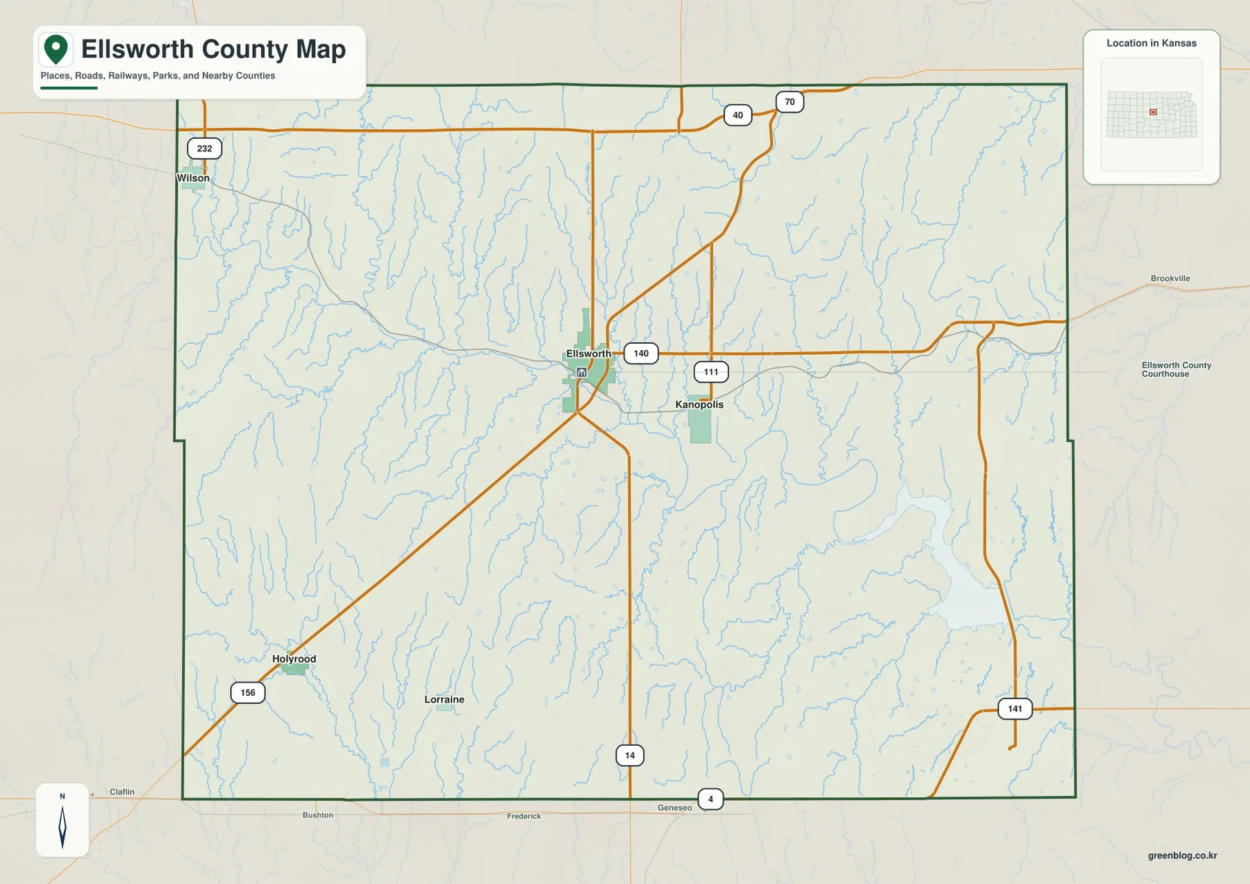
Roads east and southeast of Ellsworth bend around the Smoky Hill River and the Kanopolis Lake area, while long rural roads spread across the western and southern uplands. The general map is intended for county-scale orientation rather than live navigation. Construction, weather, closures, and road conditions can change, so current travel should be checked with an up-to-date transportation or navigation source.
Straight-line connections from Ellsworth to the surrounding communities
The city connection map uses Ellsworth as the hub and shows the relative positions of four nearby communities. Kanopolis is the closest at about 4 miles in a straight line, while Lorraine is about 13 miles away, Holyrood about 14 miles, and Wilson about 15 miles. These figures are intended to communicate scale and direction; they are not driving mileage.
The short Ellsworth–Kanopolis distance stands out because the other communities are spread much farther across the county. Wilson anchors the northwest, while Holyrood and Lorraine give the southwest a pair of recognizable reference points. Once those locations are fixed, returning to the general map makes it easier to understand which highways and local roads connect the populated areas.
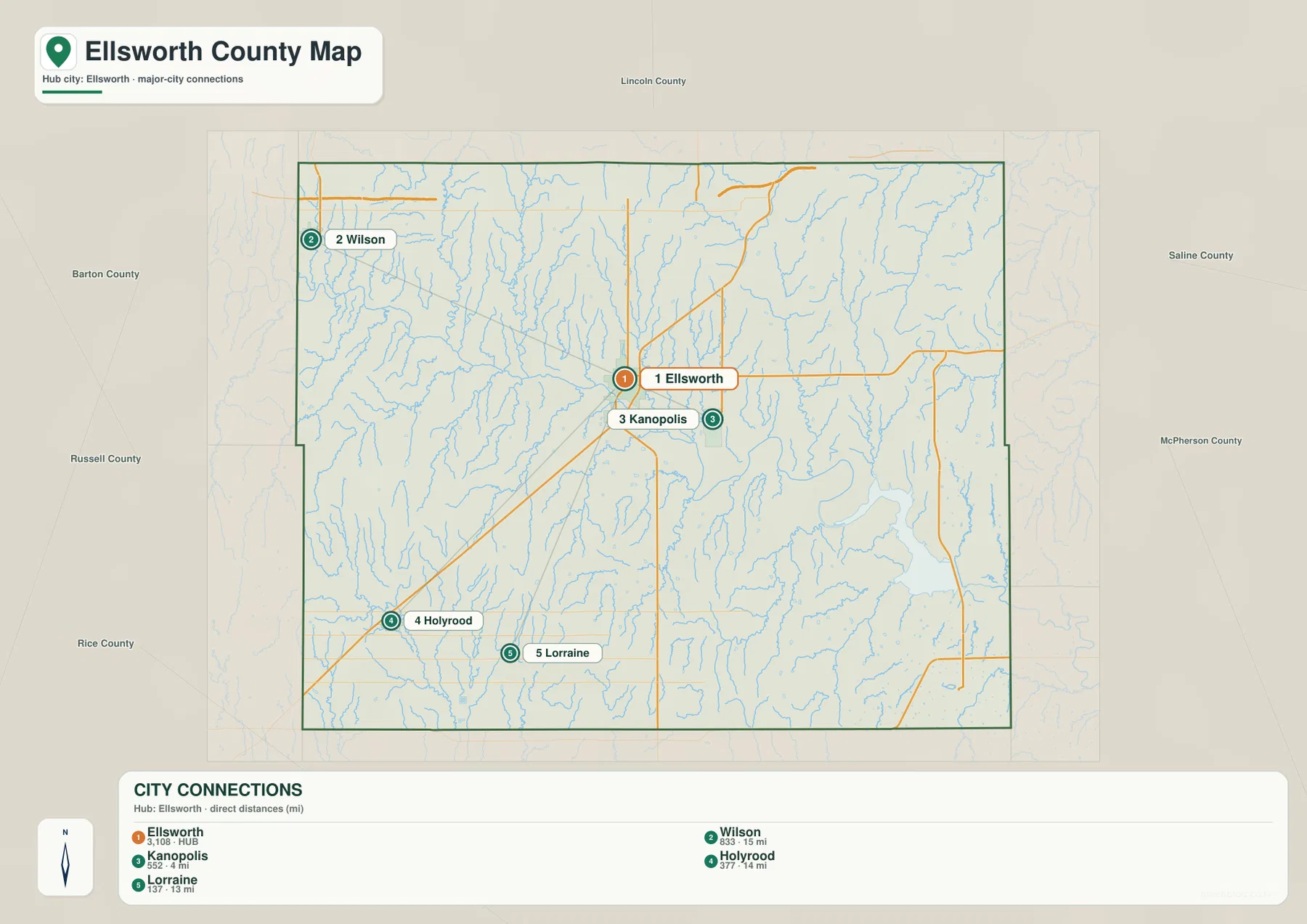
The Kansas Historical Society identifies Ellsworth as the county seat and describes the Fort Harker story associated with Kanopolis. Their close geographic relationship is therefore useful for both modern orientation and local history. The city map also makes clear that the county’s settlement pattern is not concentrated in one urban corridor; smaller communities occupy widely separated parts of the rural landscape.
The Smoky Hill River corridor and Kanopolis Lake
The terrain and water map is dominated by the Smoky Hill River. The river crosses the central part of Ellsworth County from west to east and broadens into a major low corridor before entering Kanopolis Lake. The surrounding terrain rises away from the river, and many tributaries descend from the higher country toward this central valley.
Owl Creek and Buffalo Creek are prominent in the northwest, while Oak Creek and Spring Creek cut southward through the north-central hills. Clear Creek and Alum Creek appear farther east, with Mulberry Creek in the northeast. South of the main river, Plum Creek and Thompson Creek drain different parts of the uplands and help explain the dense pattern of narrow valleys visible in the shaded relief.
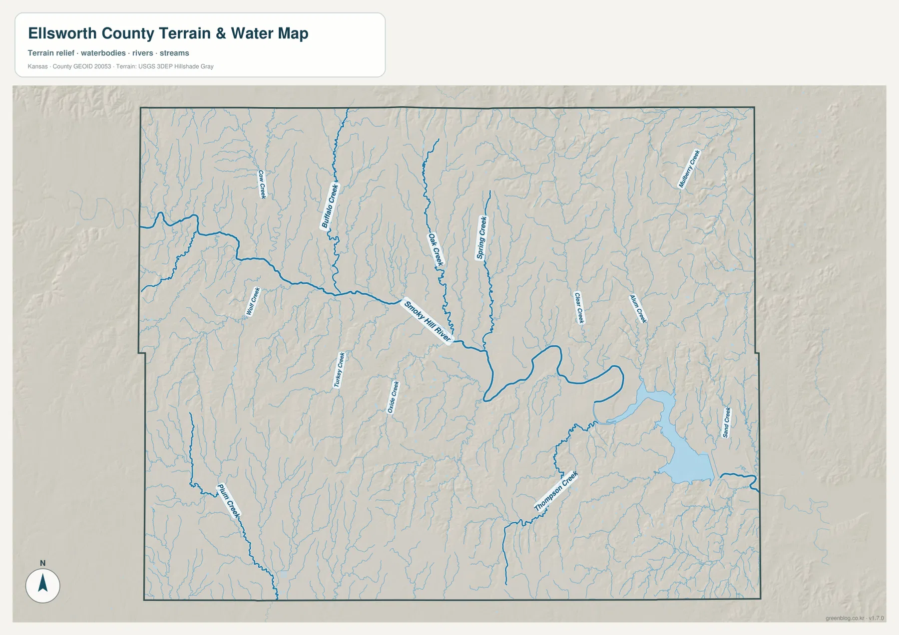
The Kanopolis Lake shoreline is especially complex because the reservoir occupies a broad, winding valley. Thompson Creek and other nearby drainages connect with the same lower terrain. The map is a geographic reference rather than a live hydrology product, so it should not be used for current lake level, flood warning, streamflow, or water-quality decisions.
A 426–593 meter landscape shaped by river valleys
The elevation map shows an actual range of roughly 426 to 593 meters and a mean elevation near 508 meters. The lowest green terrain follows the Smoky Hill River and Kanopolis Lake, creating a long central and eastern lowland. Higher yellow, orange, and brown surfaces appear away from the valley, with particularly strong relief in the southwest and parts of the northwest.
Small tributaries cut narrow green corridors into those higher surfaces. In the western half, the transition from upland to river valley is especially easy to see because the Smoky Hill River crosses below a network of dissected hills. The north also contains many closely spaced valleys, while the east includes broader lower terrain associated with the reservoir and main river.
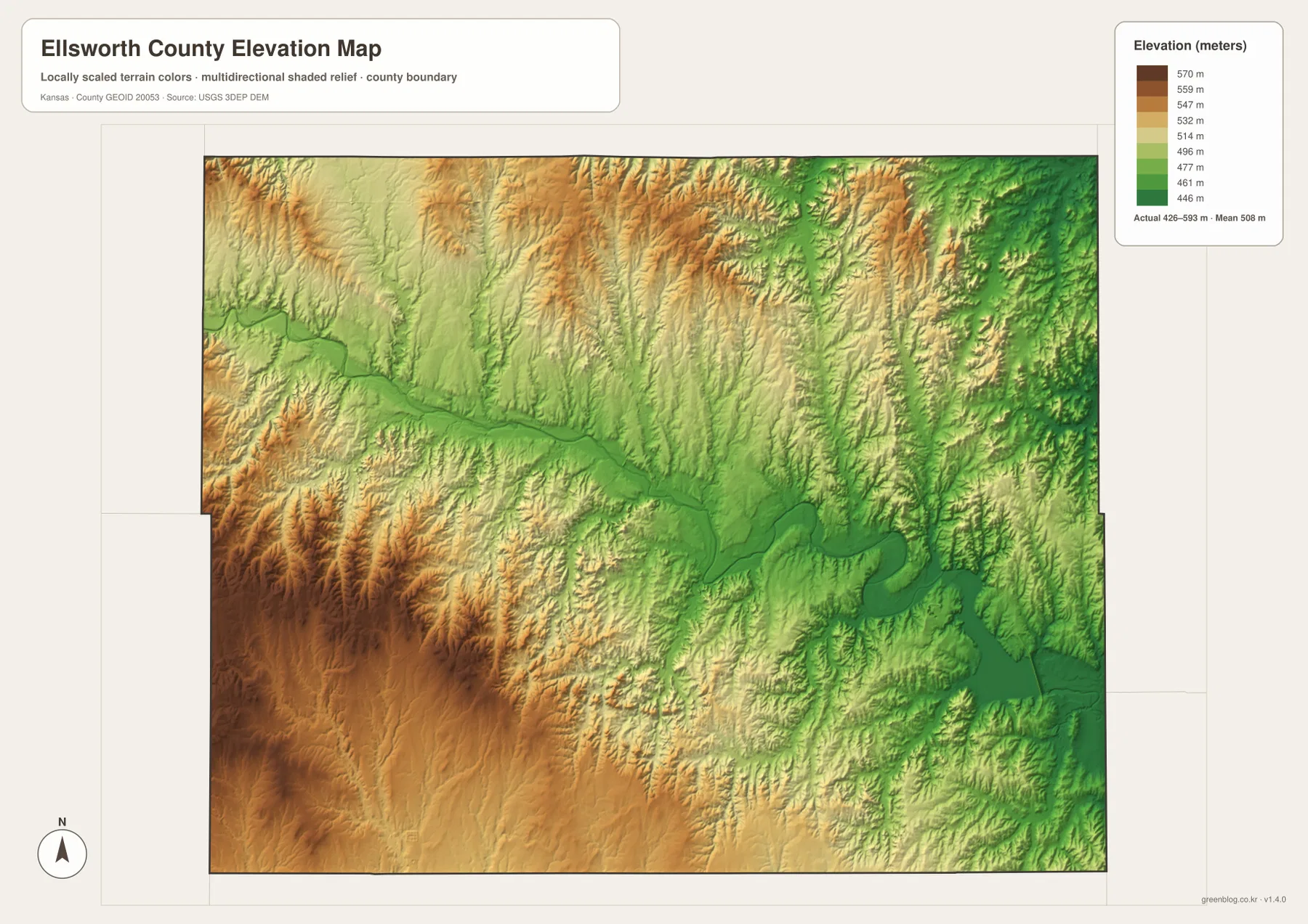
This elevation surface is intended for county-scale comparison rather than survey-grade measurement. It should not be used to establish exact parcel elevations, design drainage, or replace engineering and legal survey data. Its main value is visual context: the map clearly shows how Ellsworth and Kanopolis sit close to the principal low corridor while higher ground surrounds much of the county.
Smoky Hills geology, Ellsworth cattle history, and Fort Harker
The Kansas Historical Society describes Ellsworth County as part of the Smoky Hills, where limestone and rolling terrain helped shape the cultural landscape. In an area where timber was once scarce, local stone was widely used for fence posts, creating the well-known post-rock landscape of central Kansas. The relief map gives that history a physical setting by showing broad hills divided by stream valleys.
Ellsworth itself became an important cattle town in the 1870s. Nearby Fort Ellsworth was renamed Fort Harker and later moved to the site of present-day Kanopolis, where it supported military and transportation activity on the central plains. Because Ellsworth and Kanopolis are only a few miles apart, their historical connection is easy to understand when the city map is viewed alongside the general county map.
Kanopolis Lake and Kanopolis State Park add a modern recreation landscape to that older history. The reservoir occupies the same Smoky Hill River corridor that dominates the terrain map, so the county’s historical sites, transportation routes, river valley, and present-day recreation areas all connect through a relatively compact central zone. That combination gives Ellsworth County a distinctive identity within north-central Kansas.
Choosing a map for orientation, terrain, or printing
For basic orientation, begin with Ellsworth and Kanopolis, then place Wilson, Holyrood, and Lorraine around them. The city connection view is useful when the goal is simply to compare straight-line distance and direction. For physical geography, follow the Smoky Hill River eastward into Kanopolis Lake and then use the elevation map to see how quickly the surrounding uplands rise away from the valley.
The high-resolution JPG files in the ZIP are better suited than the reduced web previews for printing, classroom materials, and close inspection of labels. They work well for county overviews and regional comparison, but current road conditions, live water information, parcel boundaries, and exact elevations should always be checked against the latest authoritative sources when those details matter.
Frequently Asked Questions
How close are Ellsworth and Kanopolis on the map?
The city connection map places Kanopolis about 4 miles from Ellsworth in a straight line, making it the closest of the major communities shown. Road mileage varies by route, but the map makes their close central relationship immediately clear.
Why are the Smoky Hill River and Kanopolis Lake so important to the terrain?
The Smoky Hill River follows the county’s main low corridor and enters Kanopolis Lake in the east. On the elevation map, this river-and-reservoir route appears as some of the lowest green terrain, while tributaries descend from higher hills on both sides.
Can the 426–593 meter elevation map be used for surveying?
No. The elevation map is a county-scale reference for comparing uplands and valleys. Exact parcel elevations, construction design, drainage engineering, and legal surveys require purpose-built data and professional methods appropriate to those tasks.
Map File Information
Download the high-resolution JPG files corresponding to the Ellsworth County general, city connection, terrain-and-water, and elevation maps in one ZIP archive.
- Included Files: Use only the versions confirmed in the article and supplied images
- File Type: Use the confirmed download contents
- Intended Use: Printing, education, presentations, and map-based projects
Related Maps
Sources and references
- Kansas Historical Society — Ellsworth County, Kansas — county seat, Smoky Hills, cattle-town history, and Fort Harker context
- U.S. Census Bureau TIGER/Line — boundary, road, and geographic data resources
- USGS National Hydrography — hydrography and stream-network data information
- USGS 3D Elevation Program — elevation data information
Green Map creates custom-edited map images using open geographic data sources such as geoBoundaries, Natural Earth, OpenStreetMap, and government open data.
These maps are edited visual materials, not raw data files, and are provided for education, documents, presentations, and graphic reference.