Brown County occupies the northeastern part of Kansas, and the supplied maps make Hiawatha and Horton the easiest places to use as anchors. Hiawatha sits slightly north of the county’s center along U.S. 36, while Horton lies close to the southern boundary. Smaller places such as Morrill, Fairview, Robinson, Everest, Reserve, Powhattan, and Hamlin spread the settlement pattern across a much wider area than the two largest towns suggest. The four high-resolution JPG maps that correspond to the web previews on this page can be downloaded together from the file box below. High-resolution map files are available for download in the section below.
The road network looks fairly orderly at first glance, but the terrain and water layers reveal a much more dissected landscape. Wolf River bends through the central and eastern side, joined by Middle Fork Wolf River and South Fork Wolf River farther south. Delaware River occupies a separate valley in the southwest, while Walnut Creek and numerous tributaries cut the north and west. The elevation map gives an actual range of about 261 to 409 meters with a mean near 332 meters, clearly separating the higher western uplands from lower stream corridors.
A practical way to learn the county is to begin at Hiawatha, follow U.S. 36 toward Fairview and Robinson, and then look south to Horton and the state highways near the county line. From there, the water and elevation views explain why a simple grid of roads crosses so many narrow valleys. This approach also keeps the discussion tied to visible map features rather than treating Brown County as a generic rural county.
Table of Contents
Using Hiawatha as the Main Orientation Point
Hiawatha is the strongest visual anchor on the general county map. U.S. 36 runs east and west through the city, placing Fairview on the western side of the same corridor and Robinson farther to the east. A north-south route continues toward Horton, while Reserve appears near the northern edge and Morrill and Hamlin sit in the northwest. With Hiawatha near the middle of these places, the county’s overall layout becomes easy to organize before looking at smaller roads and streams.
Horton provides a second useful anchor in the south. Kansas 20 crosses the southern part of the county, while routes 159 and 73 meet the broader road network around Horton and Everest. Route 75 appears farther west near the county line. Powhattan lies inland from the southwestern side, giving the general map another reference between the western roads and the Hiawatha-Horton corridor.
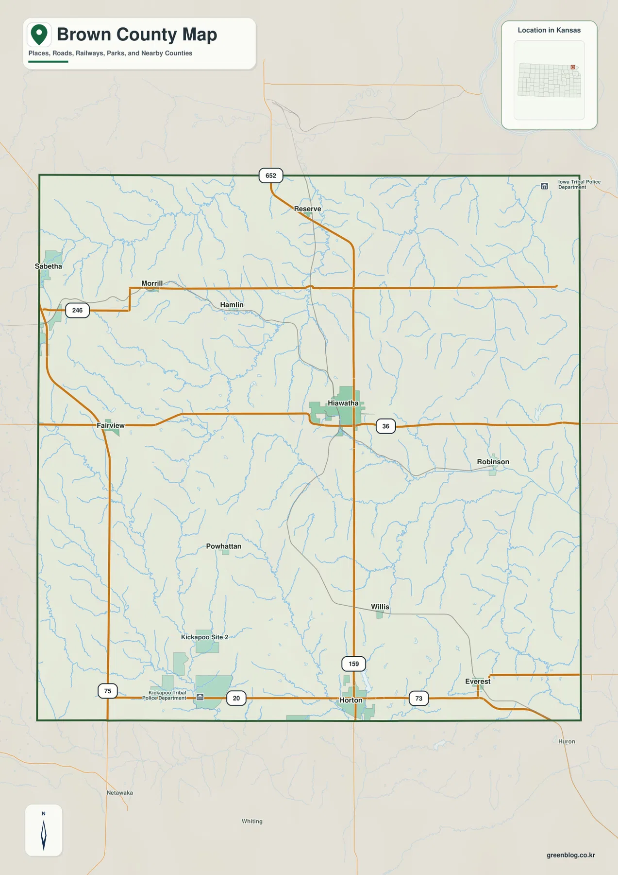
The map also includes labels connected with tribal facilities and communities, including Kickapoo Site 2, Kickapoo Tribal Police Department, and Iowa Tribal Police Department. These are useful geographic labels because they help identify specific parts of the county, but they should not be interpreted as legal reservation boundaries or jurisdiction lines. The preview is designed for orientation, not for defining contemporary legal territory.
This general view works best when the question is where a place or road is located. It keeps towns, highways, county limits, and many small blue stream lines in one frame. It does not show the depth of valleys very well, and a dense collection of tributaries can be hard to understand at web size. Once Hiawatha and Horton are familiar, the water and relief maps make those stream patterns much easier to interpret.
A Settlement Pattern Led by Hiawatha and Horton
The ranked city map highlights six principal places. Values printed on the supplied map are Hiawatha 3,197, Horton 1,610, Everest 356, Fairview 342, Morrill 210, and Robinson 154. These numbers should be treated as values embedded in the map rather than as current population estimates, but they still make the relative scale of the settlement pattern clear. Hiawatha is the largest of the six, Horton forms the second major center, and the remaining towns are much smaller.
Their locations are as informative as their ranked values. Hiawatha sits slightly north of center, Horton is near the southern edge, Fairview marks the west-central side, and Morrill provides a northwestern reference. Robinson lies east of Hiawatha, while Everest is east of Horton in the southern part of the county. The spacing suggests a dispersed rural pattern rather than one continuous built-up corridor.
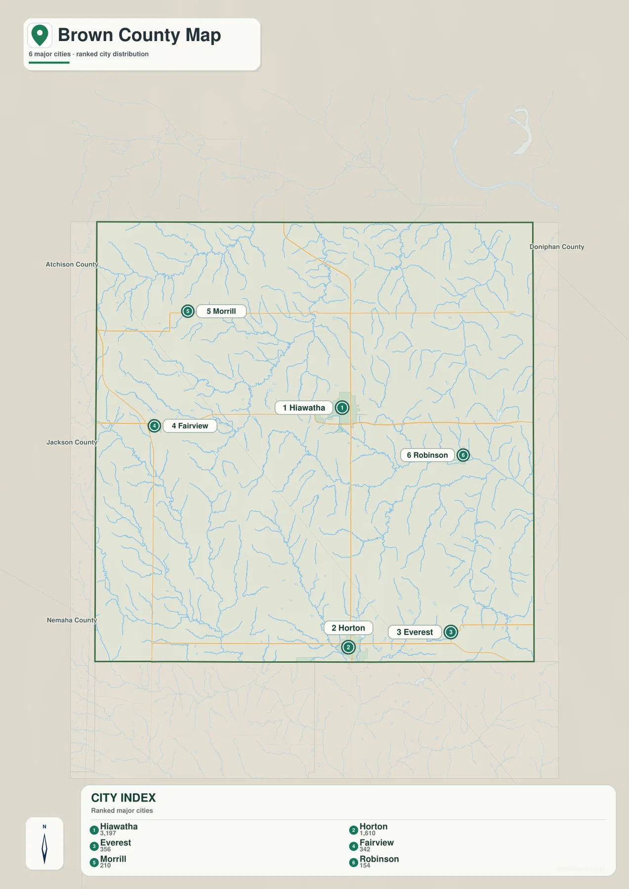
The simplified city view retains enough road and stream context to show that the towns occupy different physical settings. Hiawatha and Robinson are close to the Wolf River drainage, while the western towns approach higher ground and a dense set of smaller tributaries. Horton stands among southern stream networks that eventually feed larger river systems. Comparing this map with the elevation layer helps separate settlement size from terrain, since a small town can occupy either higher or lower ground.
This map should not be used to estimate driving distance by measuring the screen. Actual travel depends on how the numbered roads and local roads connect, and current closures can change a route. Its strength is visual comparison: it quickly answers which towns are the main centers and where they sit relative to the county outline. The general road map can then provide the route detail that the ranked city view deliberately removes.
Wolf River, Delaware River, and the County’s Major Drainages
Wolf River dominates the central and eastern drainage pattern. It bends across the county near Hiawatha before continuing east, while Middle Fork Wolf River approaches from the south-central area and South Fork Wolf River occupies a longer corridor in the southeast. Their combined shape explains why the eastern half contains so many branching tributaries and narrow valleys even where the road grid appears regular.
Delaware River forms a separate major valley in the southwest. Plum Creek and smaller streams feed that side of the county, while Spring Creek and Mulberry Creek cut the west and northwest. Walnut Creek runs through the north-central interior and gathers multiple tributaries before continuing southward. Pony Creek is labeled farther north, adding another reference for the high, dissected terrain in that part of the map.
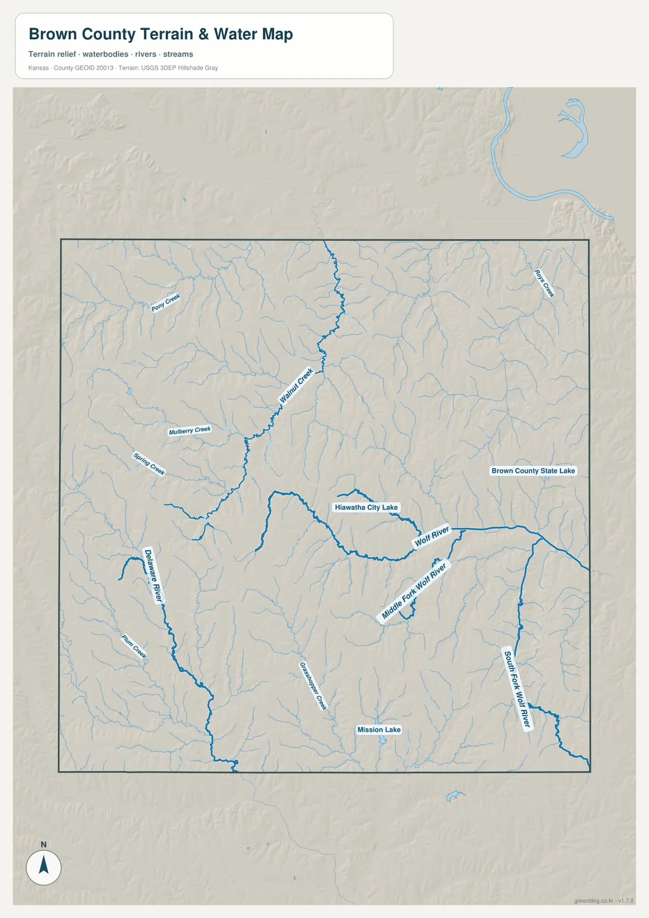
Several named lakes help with local orientation. Hiawatha City Lake appears near the central-eastern part of the county and the Wolf River system, Brown County State Lake is farther east, and Mission Lake is labeled in the southern interior. These water bodies are useful map landmarks, but the page does not imply current lake level, access status, water quality, or fishing conditions. Those details require current information from the responsible agencies.
The water layer is also a reminder that the county’s blue lines represent a drainage network, not a live flood map. Heavy rain can change stream levels, low-water crossings, and local road conditions quickly. For emergency decisions, current weather and local transportation information should take priority. As a geographic reference, however, the map clearly shows how the Wolf River system shapes the east while Delaware River and smaller creeks divide the west and southwest.
Relief from 261 to 409 Meters across Brown County
The elevation map reports an actual county range of about 261 to 409 meters and a mean near 332 meters. Browns and oranges are concentrated along the western side and in parts of the northwest, while greener colors mark lower valleys in the east, north-central interior, and southwest. The roughly 148-meter difference between the highest and lowest mapped elevations is enough to produce repeated ridge-and-valley patterns rather than a uniformly flat surface.
Higher western terrain is cut by many narrow green tributary corridors, so it should not be imagined as one broad plateau. The northwestern side contains numerous short ridges and incised channels that descend toward larger creeks. Near the center, Walnut Creek creates another lower line through the uplands. In the east, the Wolf River and its forks form long green corridors that stand out clearly against surrounding higher ground.
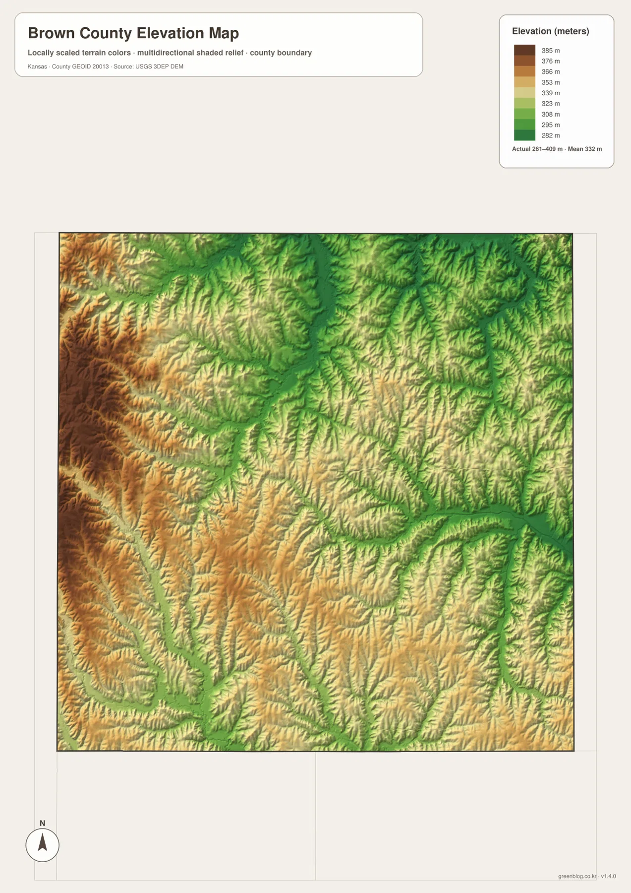
Hiawatha lies in a useful transition zone for reading this pattern. Higher ridges are more common to the west, while the Wolf River drainage creates lower terrain to the east and southeast. Horton sits among southern tributaries, and the Delaware River valley cuts lower ground through the southwestern part of the county. Remembering the town locations from the general map makes the relief colors much more meaningful even though the elevation view itself does not emphasize settlement labels.
This layer is a generalized countywide elevation surface, not a parcel survey. It is suitable for comparing broad uplands and valleys, understanding stream corridors, and explaining regional terrain. It should not be used to determine a building-pad elevation, property slope, drainage design, or engineering grade. Those tasks require higher-precision source data and, when necessary, professional measurement.
Following U.S. 36 and the Southern Highway Network
U.S. 36 is the clearest east-west route on the county map. It passes through Hiawatha, places Fairview to the west on the same broad corridor, and continues toward Robinson and the eastern side. Because the road crosses many small drainages that are visually understated on the general map, comparing the highway with the water layer is useful. A line that looks simple on the road map actually passes across a landscape broken by tributaries and narrow valleys.
The southern road network is more concentrated around Horton. Kansas 20 runs along the southern part of the county, route 159 links the Hiawatha-Horton direction, and route 73 extends toward Everest. Route 75 appears farther west. Together they make Horton a practical reference for the southern tier, but they are geographic guides rather than live navigation instructions. Construction, detours, and travel times should always be checked with current transportation sources.
The northern part of the county has smaller communities and a less dominant road pattern. Around Reserve and Morrill, local roads cross many branches of Walnut Creek and neighboring tributaries. In the northeast, the drainage network becomes especially dense. The high-resolution general map is useful here because it preserves the relationship between small road labels and blue stream lines better than the reduced web preview.
Tribal Place Labels and Other Local Reference Points
The supplied map includes labels associated with tribal communities and facilities, notably Kickapoo Site 2, Kickapoo Tribal Police Department, and Iowa Tribal Police Department. These labels are part of the local geography visible in the source map and help distinguish parts of Brown County that might otherwise look similar. Kansas Historical Society material also describes the long history of the Kickapoo Tribe, Iowa Tribe, and Sac and Fox Nation in and around the county.
Those references need careful interpretation. A point label for a police department or named site is not the same thing as a legal boundary. Reservation limits, tribal jurisdiction, property status, and access rules should be checked with authoritative current sources rather than inferred from the cartographic placement of a label. For this page, the labels are used only as geographic landmarks shown on the supplied county map.
Hiawatha is identified by the Kansas Historical Society as the county seat, and it also appears as the largest ranked city on the supplied city map. That combination makes it an especially useful starting point for orientation. Reserve provides a northern reference, Robinson an eastern one, Powhattan a southwestern interior point, and Horton the strongest southern anchor. Linking these places to roads and streams gives the map more meaning than listing town names by themselves.
Matching Each Map to a Practical Question
For county boundaries, numbered routes, and the positions of named places, the general map is the most efficient starting point. It keeps Hiawatha, Horton, Fairview, Morrill, Robinson, Reserve, and other labels together with the road network. It is also the easiest map for explaining where the county’s larger and smaller communities sit relative to one another before introducing natural features.
The ranked city map is better when the main question is settlement distribution. It removes much of the background detail and emphasizes the contrast between Hiawatha and Horton and the four smaller ranked places. The water-and-terrain view is the stronger choice for Wolf River, Delaware River, Walnut Creek, lakes, and branching tributaries. The elevation layer then adds a clear answer to a different question: where the land is broadly higher or lower.
A county-specific report can use contrasting locations instead of repeating a generic description of four map types. Hiawatha illustrates the meeting of settlement, U.S. 36, and the Wolf River drainage. Horton represents the southern road network, while Fairview and Morrill help explain the higher western side. Robinson and Everest provide eastern and southeastern references closer to lower river valleys. These examples keep the discussion grounded in Brown County itself.
What to Examine in the High-Resolution Downloads
The web previews are convenient for learning the overall pattern, but the original JPG files are better for small labels, short tributaries, and local road details. Each original measures 3638 by 2572 pixels. The download archive contains the general county map, ranked city map, water-and-terrain map, and elevation map, allowing the same location to be compared across all four views without relying on the smaller page images.
For the north, enlarge Reserve, Morrill, Walnut Creek, and the dense tributary network around them. In the southwest, compare Fairview and Powhattan with Delaware River, Plum Creek, and the higher relief nearby. Around Hiawatha, trace U.S. 36 and then switch to the water map to follow Wolf River and Hiawatha City Lake. The southern files make Horton, Everest, Mission Lake, and the South Fork Wolf River system easier to inspect.
These files are intended for general geographic reference, classroom use, presentations, personal study, and ordinary printing. They do not replace legal boundary records, parcel ownership information, flood determinations, current road-control notices, or professional survey products. Their advantage is simply that the same mapped information shown on the page can be enlarged and printed at much higher resolution.
Frequently Asked Questions
Which map is best for locating Hiawatha and Horton?
Start with the general county map. Hiawatha is easy to find on U.S. 36, while Horton appears near the southern edge among Kansas 20, 159, and 73. The ranked city map then simplifies the same relationship and shows Hiawatha and Horton as the two largest mapped centers. Using those two views together gives a clearer result than trying to infer roads from the city ranking alone.
How do Wolf River and Delaware River relate to the elevation pattern?
The Wolf River system occupies lower corridors through the central, eastern, and southeastern parts of the county, while Delaware River forms another low valley in the southwest. On the elevation map, these drainage corridors appear greener than much of the western upland. The displayed county range is about 261 to 409 meters, which is useful for broad comparison but not for parcel-level or engineering measurements.
What is included in the Brown County download ZIP?
The archive contains four high-resolution JPG files corresponding to the maps shown on the page: the general county map, ranked city map, water-and-terrain map, and elevation map. Each original is 3638 by 2572 pixels. They are useful for zooming, ordinary printing, classroom work, and geographic reference, but they do not replace legal, engineering, emergency, or survey information.
Map File Information
Download the high-resolution JPG originals corresponding to the Brown County general map, city map, water-and-terrain map, and elevation map shown on this page.
- File Type: ZIP containing 4 JPG files
Related Maps
Sources and References
Authoritative background sources include the U.S. Census Bureau TIGER/Line Shapefiles, USGS National Hydrography, and USGS 3D Elevation Program. Current county information is available from the official Brown County, Kansas website, while historical background and confirmation of Hiawatha as the county seat can be found in the Kansas Historical Society Brown County, Kansas profile. Geographic descriptions on this page focus on features visible in the supplied maps.
Green Map creates custom-edited map images using open geographic data sources such as geoBoundaries, Natural Earth, OpenStreetMap, and government open data.
These maps are edited visual materials, not raw data files, and are provided for education, documents, presentations, and graphic reference.