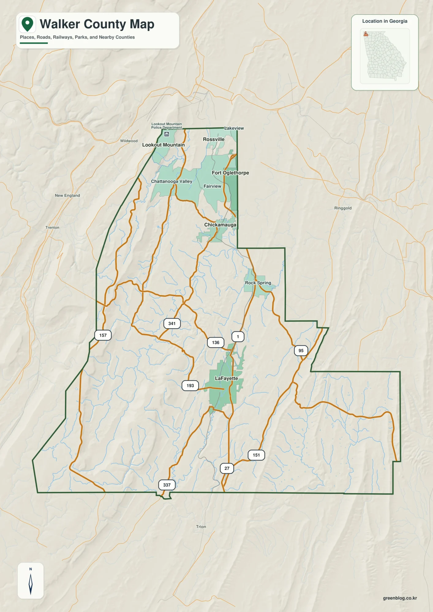
Atchison County occupies a distinctive corner of northeastern Kansas where the city of Atchison sits against the Missouri River while Lancaster, Effingham, Muscotah, and Huron are spread across the interior. The road map gives the first impression of a rural county organized around one larger eastern city, but the water and elevation views reveal a much more textured landscape. Broad river lowlands occupy the eastern edge, and a dense network of tributary valleys cuts into higher ground farther west. The four map views on this page can be browsed online, and matching high-resolution JPG originals are available together in a downloadable ZIP.
For orientation, Atchison and the Missouri River are the easiest anchors. Atchison occupies the eastern edge of the county, with Kansas 9 and U.S. 73 meeting the city from the west and Kansas 7 continuing south along the river side. Lancaster lies inland to the west, with Effingham farther southwest, Muscotah near the western side, and Huron in the northern interior. Once those places are located, the county becomes much easier to read because roads, streams, and elevation changes can all be compared against the same set of reference points.
The official Atchison County visitor page describes the county as having been founded in 1855 and connects the Atchison area with Amelia Earhart, railroad history, historic architecture, industry, agriculture, and Benedictine College. That context helps explain why the city of Atchison appears as such a strong geographic center on the maps. This article, however, stays focused on what the supplied map set can show directly: settlement spacing, road connections, water features, and county-scale relief.
Table of Contents
Atchison on the Missouri River as the Eastern Anchor
The general county map makes Atchison immediately recognizable because its built-up area is shaded prominently along the eastern boundary. The Missouri River bends beside the city and then continues south, creating an irregular edge that looks very different from the straighter western and southern county lines. Kansas 9 and U.S. 73 are labeled just west of the city, while Kansas 7 follows the eastern side farther south. Benedictine College and Atchison Hospital appear as additional local landmarks within the Atchison area.
Moving inland, Lancaster is the next clearly labeled community west of Atchison. Effingham lies farther southwest, Muscotah is near the western side, and Huron occupies the northern interior. Those towns do not form one simple line, and the road network reflects that dispersed pattern. Routes branch toward different parts of the county instead of following a single dominant corridor from one border to the other. This makes the general map especially useful when the goal is to understand how the county is organized rather than simply identify its largest city.
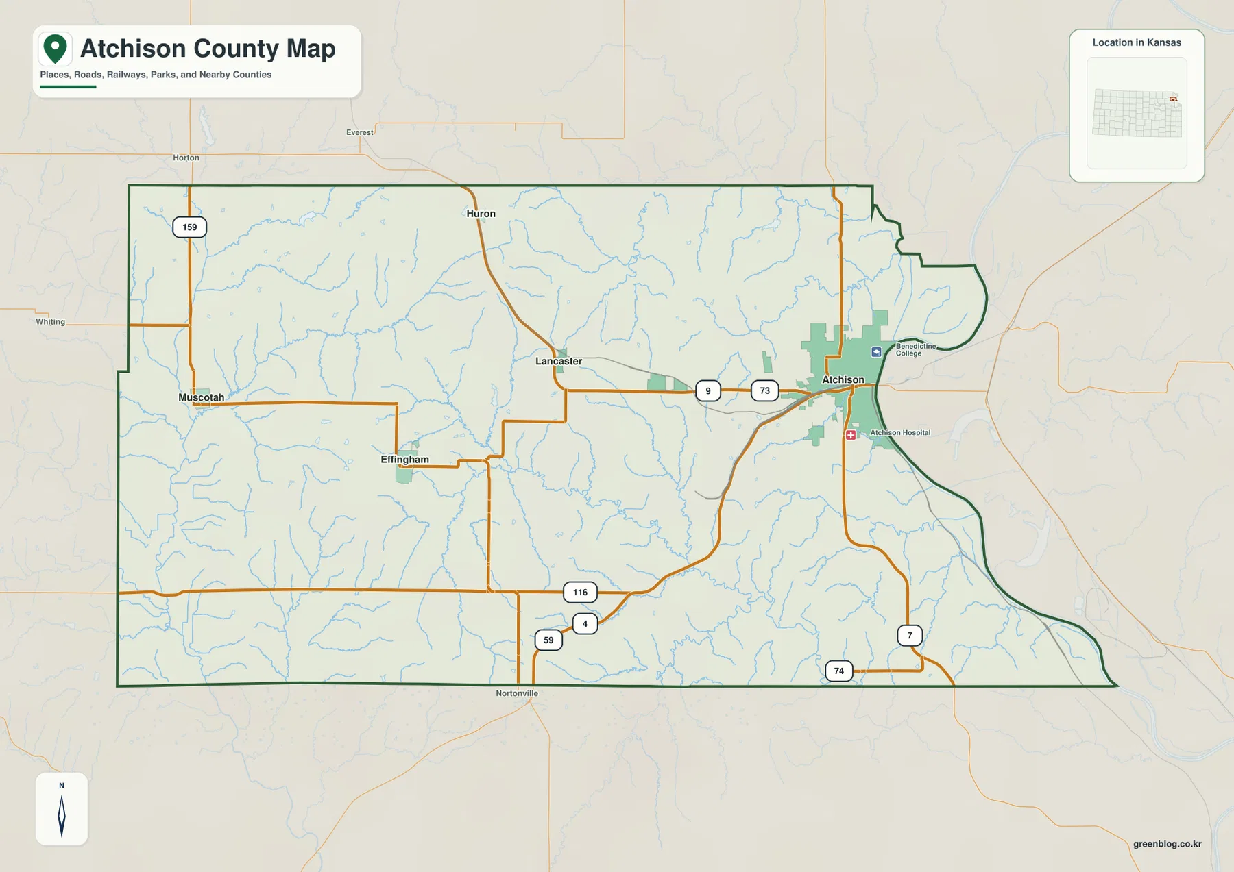
Places outside the county help with regional orientation as well. Horton is visible beyond the northwestern side, Whiting appears to the west, and Nortonville is labeled south of the county. These reference points are useful when Atchison County is viewed alongside neighboring county maps. The eastern boundary is especially memorable because the river creates large curves and a narrow northeastern projection, while much of the interior boundary follows straighter administrative lines.
Thin blue streams appear throughout the general map, particularly around Lancaster and across the southern interior. Their density hints at the dissected terrain, but roads and place labels make it difficult to follow individual channels here. The water map is better for named creeks and larger drainage relationships, while the elevation map shows which of those corridors occupy the lowest ground. Using the general map first provides a geographic framework before switching to the more specialized views.
A Settlement Pattern Dominated by Atchison but Spread Inland
The ranked city map reduces the county to five principal communities. In the supplied index, Atchison is shown at 10,785, followed by Effingham at 786, Lancaster at 325, Muscotah at 141, and Huron at 70. These values are most useful for comparing the relative prominence of the mapped places rather than serving as a substitute for a current official population estimate. Visually, the important point is the strong size difference between Atchison and the smaller communities scattered through the rest of the county.
Lancaster occupies a useful middle position between Atchison and the western towns, while Effingham lies to its southwest. Muscotah sits close to the western side, and Huron is farther north. Because the smaller communities are separated in several directions, Atchison County does not have the appearance of a chain of towns along one road. The pattern is more dispersed, with the largest urban center pressed against the Missouri River and smaller places representing distinct portions of the rural interior.
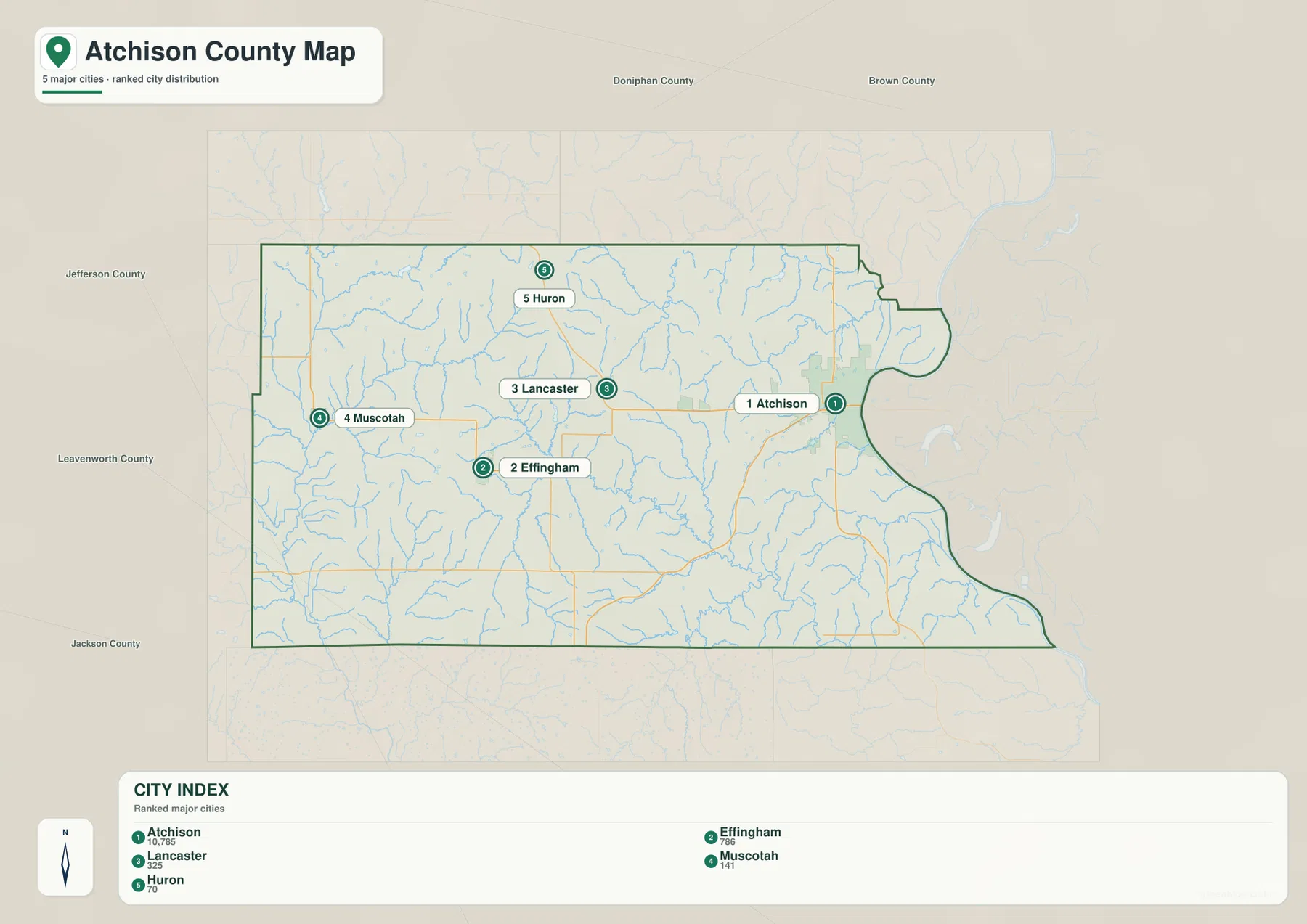
The city map also labels surrounding counties, including Doniphan, Brown, Jefferson, Leavenworth, and Jackson. That context helps explain why different parts of Atchison County face different neighboring regions. The Atchison side is tied closely to the Missouri River edge and the northeastern corner of Kansas, while Muscotah and Huron sit much closer to inland county boundaries. When several Kansas county pages are being compared, these surrounding names make it easier to maintain orientation from one map to the next.
Because the city view suppresses most road detail, it should not be treated as a route map. Its strength is spacing and relative prominence. To understand how Atchison, Lancaster, Effingham, Muscotah, and Huron connect by road, return to the general map and compare the highway labels and local branches. Used together, the two maps separate two different questions: where the settlements are and how the transportation network reaches them.
Missouri River Lowlands and a Web of Interior Creeks
The terrain-and-water map shifts attention away from highways and makes the drainage pattern much easier to see. The Missouri River forms the major eastern feature, creating a broad low corridor beside Atchison and continuing south along the county edge. On the opposite side of the county, the Delaware River runs near the western boundary. Between those two larger rivers, the interior is divided by many smaller tributaries that carve narrow valleys into the uplands.
Stranger Creek is one of the most prominent named interior waterways, bending across the central and southern part of the county and receiving numerous smaller channels. Little Stranger Creek occupies a separate southern corridor, while Independence Creek crosses the northern interior. Deer Creek appears in the northeast, and Walnut Creek reaches toward the Missouri River side. Together these waterways show that the county is not drained by one simple central river; instead, several local valleys direct water toward different larger systems.
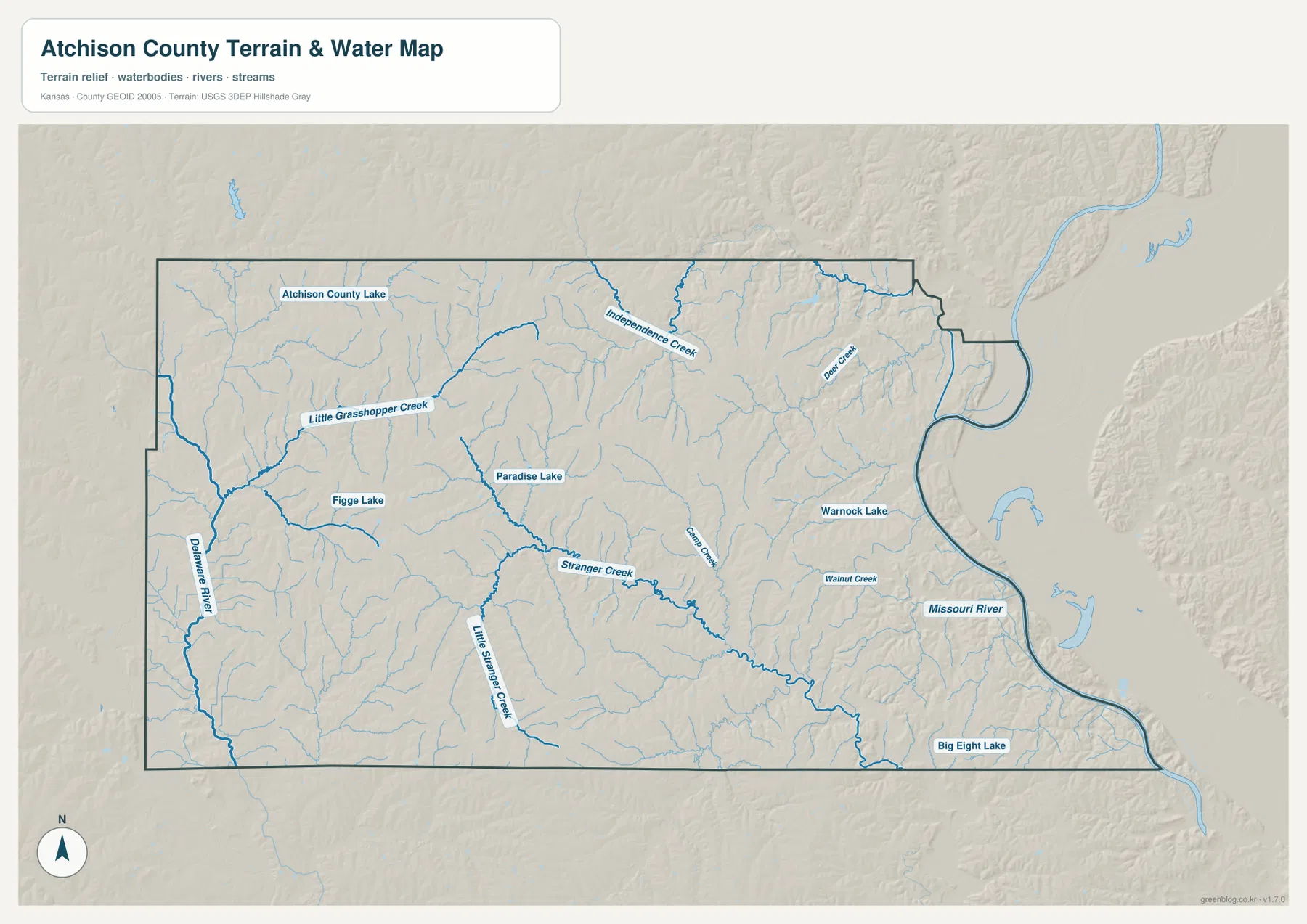
Several small lakes are labeled as useful geographic markers. Atchison County Lake appears in the northwest, Paradise Lake is near the central interior, Figge Lake is farther west, Warnock Lake is east of center, and Big Eight Lake is near the southeastern side. None dominates the county at this scale, but each helps connect the hydrography map with nearby roads or communities. Paradise Lake, for example, makes the Stranger Creek area easier to locate when switching between map types.
This is a general geographic water reference rather than a flood-hazard, legal-boundary, access-rights, or navigation product. Stream conditions can change with rainfall and season, and small channels may be intermittent or difficult to see on the ground. The map is most valuable for county-scale relationships: a very large river lowland lies on the east, another major river corridor touches the west, and a dense network of tributaries breaks the higher interior into many smaller valleys.
Relief from About 233 to 359 Meters
The supplied elevation map reports an actual county range of roughly 233 to 359 meters, with a mean near 314 meters. The lowest green colors follow the Missouri River side most clearly, especially along the eastern edge where the river valley broadens. Higher tan and brown tones occupy much of the central and western interior. The shaded relief makes the uplands look strongly dissected, with many narrow valleys cutting into ridges that are almost invisible on the basic road map.
Atchison sits beside some of the lowest terrain in the county. Moving west toward Lancaster brings a quick transition from the broad river lowland into rolling uplands, and the terrain becomes even more visibly broken around parts of Effingham and Muscotah. Huron also lies among generally higher ground, although Independence Creek and its tributaries create lower channels through the northern interior. The result is not a simple flat plateau but a repeated pattern of ridges separated by stream valleys.
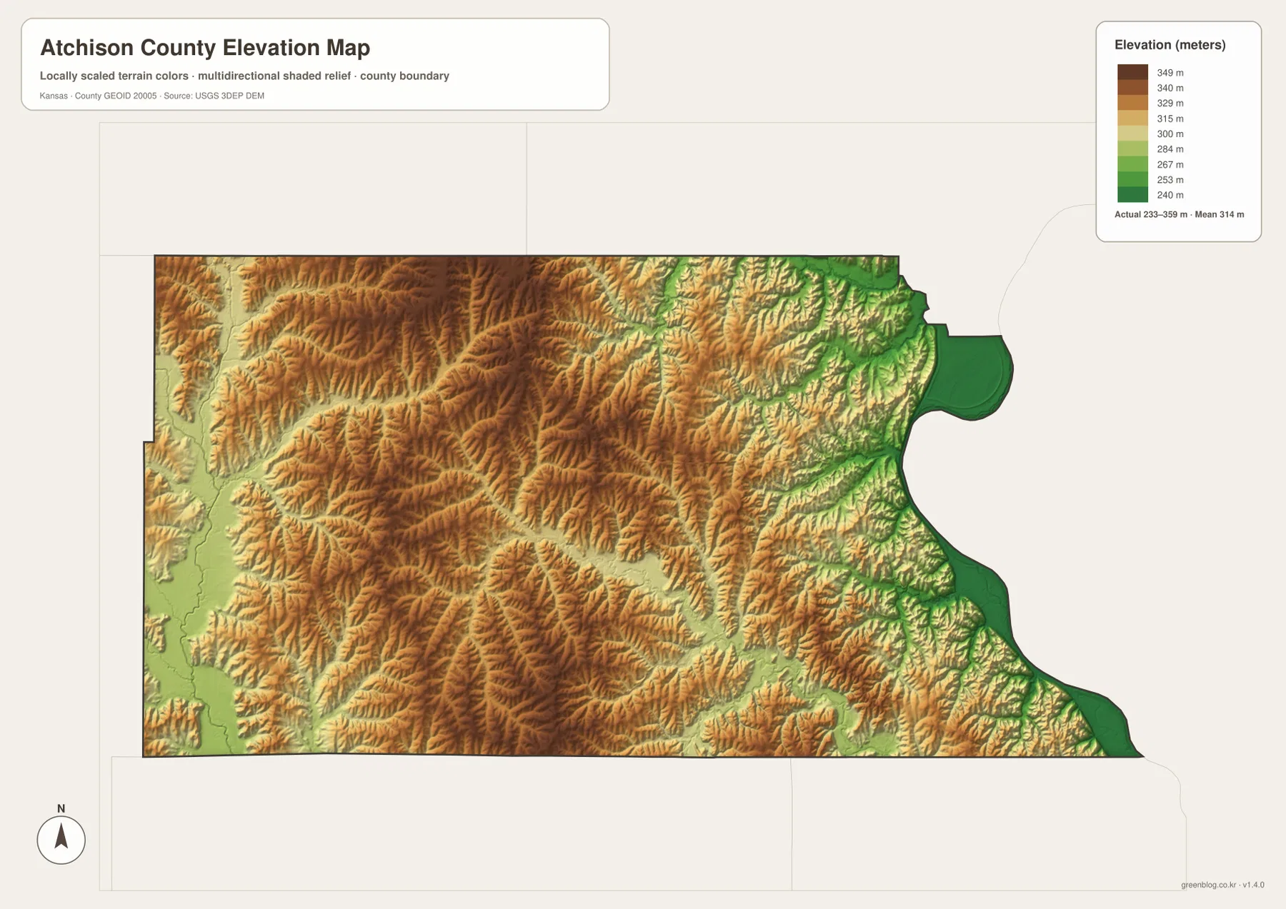
Comparing the water and elevation views explains many of the green corridors. The Missouri River occupies the broadest lowland, while Stranger Creek, Independence Creek, and other tributaries create narrower low paths through higher terrain. The Delaware River side also contains lower ground, but it does not form the same broad continuous strip seen along the eastern river. This contrast is one reason the county cannot be described accurately as sloping evenly from one border to the other.
The elevation colors are generalized for county-scale comparison and are not survey-grade measurements. They should not be used to determine a building pad elevation, drainage design, road grade, or property-specific engineering value. For those purposes, current professional or USGS data is necessary. For geographic learning, however, the map does an excellent job of showing why Atchison sits in a low river setting while many inland communities occupy higher, more dissected terrain.
Reading Atchison, Lancaster, and the Interior Across All Four Maps
Atchison is the best single place to compare across the entire collection. On the general map it is the largest built-up area and a road focus. On the water map it lies directly beside the Missouri River, and on the elevation map it occupies one of the lowest parts of the county. The city map confirms its much greater prominence relative to the other mapped communities. Those four perspectives describe the same place from different angles without forcing every type of information into one crowded image.
Lancaster and Effingham provide a useful inland comparison. Both are removed from the broad Missouri River lowland and surrounded by a much denser pattern of small tributary valleys. The terrain around Effingham is particularly connected to the Stranger Creek system, while Lancaster sits closer to the transition between the eastern lowlands and higher interior ridges. Their road positions make more sense when the water and relief maps are considered alongside the general map.
Muscotah and Huron illustrate the western and northern parts of the county. These areas are generally higher than the Missouri River edge, but the Delaware River, Independence Creek, and smaller tributaries still form low passages through the uplands. It would therefore be misleading to describe the entire western side as uniformly high. A better summary is that broad uplands are repeatedly divided by narrow valleys, creating a rolling landscape that changes noticeably over short distances.
Choosing the Right View and Downloading the High-Resolution Maps
For overall orientation, start with the general county map. It combines Atchison, Lancaster, Effingham, Muscotah, Huron, major road labels, the Missouri River boundary, and numerous minor streams. The ranked city map is more useful when the main question is how the five mapped communities compare in size and spacing. Because it removes most transportation detail, the settlement pattern is visible immediately.
Choose the terrain-and-water map when you need the Missouri River, Delaware River, Stranger Creek, Little Stranger Creek, Independence Creek, Deer Creek, or the named lakes. The elevation map answers a different question by emphasizing the contrast between broad river lowlands and higher inland ridges. Placing those two physical maps side by side is especially helpful because the lowest bands frequently line up with the named streams.
The embedded WebP images are convenient for quick browsing, but small place names and road shields can be difficult to read on a normal screen. The downloadable ZIP contains the high-resolution JPG originals corresponding to the general county, city distribution, terrain-and-water, and elevation maps. Each JPG is 3638 × 2572 pixels, making the originals better suited to enlarged viewing, personal reference, classroom material, or draft printing.
These maps are intended for general geographic understanding. They do not replace legal boundary records, property surveys, live navigation, flood certification, engineering design, or current road-condition services. When an authoritative answer is required, consult Atchison County, the U.S. Census Bureau, USGS, or another responsible agency. The value of the collection is that roads, settlements, water, and relief can be examined separately and then compared without losing the county-wide context.
Frequently Asked Questions
Which map is best for comparing Atchison with Lancaster, Effingham, Muscotah, and Huron?
Use the ranked city map first when you want a quick view of relative settlement size and spacing. Add the general county map when you need road context. Atchison is the dominant eastern center on the Missouri River, while Lancaster, Effingham, Muscotah, and Huron occupy different parts of the interior, so the two maps answer complementary questions.
Where is the lowest terrain in Atchison County?
The broadest low area on the supplied elevation surface is along the Missouri River on the eastern side of the county. The full mapped range is about 233 to 359 meters, with a mean near 314 meters. Lower corridors also follow the Delaware River and interior tributaries, but much of the central and western county is higher and more strongly dissected.
Can the Missouri River and Stranger Creek map be used for flood or property decisions?
No. The terrain-and-water map is a general reference showing the Missouri River, Delaware River, Stranger Creek, Independence Creek, other tributaries, and named lakes. Current flood conditions, legal property boundaries, drainage rights, public access, and water levels should be verified with USGS, Atchison County, and other responsible authorities.
Map File Information
The ZIP contains the high-resolution JPG originals corresponding to the Atchison County general, city distribution, terrain-and-water, and elevation maps shown on this page.
- File Type: ZIP containing 4 JPG files
Related Maps
Sources and References
For county government and local context, see the official Atchison County website and its visitor information page. Boundary and base geography can be checked through the U.S. Census Bureau TIGER/Line files, water features through USGS National Hydrography, and terrain through the USGS 3D Elevation Program.
Green Map creates custom-edited map images using open geographic data sources such as geoBoundaries, Natural Earth, OpenStreetMap, and government open data.
These maps are edited visual materials, not raw data files, and are provided for education, documents, presentations, and graphic reference.