Anderson County sits in eastern Kansas, with Garnett as the clearest center and U.S. 169 forming a diagonal route from the Colony area through Garnett toward Greeley. Smaller communities such as Westphalia, Kincaid, Lone Elm, and Welda spread across the county rather than lining up on a single corridor. The four maps on this page show that road-and-town pattern alongside the county’s creeks, lakes, and relief. High-resolution JPG originals corresponding to all four web maps are also available together in a downloadable ZIP.
Garnett is the easiest place to begin because it connects the transportation, settlement, and physical geography views. On the general map, U.S. 169 bends past the city and continues toward the northeastern part of the county. On the terrain maps, the same area lies near the Pottawatomie Creek drainage and a cluster of named lakes. Looking south from Garnett leads into more strongly dissected uplands, while the northeastern creek corridors occupy noticeably lower ground.
The official Anderson County website places county government offices in Garnett, reinforcing the city’s role as the administrative reference point. The map set adds geographic context around that center: Lake Garnett and Crystal Lake appear near the northern interior, Andrews Lake is farther northwest, and Welda Lake lies to the south. Rather than treating the four images as an inventory, this guide follows the relationships among roads, communities, waterways, and elevation so that each view answers a different question about the same county.
Table of Contents
Using Garnett and U.S. 169 to Orient the County
The general county map makes Garnett stand out immediately. Its built-up area is shaded, and U.S. 169 passes close enough to serve as a strong visual anchor even when the smaller local roads and streams make the map busy. From the southwest, the highway enters near Colony, runs through the Welda–Garnett part of the county, and then bends toward Greeley in the northeast. Because the route crosses the county diagonally rather than as a straight north–south line, it helps explain why several communities relate to Garnett from different directions.
West of Garnett, Harris and Westphalia occupy separate parts of the rural road network. The southern half contains Colony, Welda, Lone Elm, and Kincaid, with Kincaid especially useful as a reference for the southeastern corner. Route shields near that area include 31 and 59, while 52 appears near the eastern edge. Those labels matter because Anderson County does not have one dominant east–west highway that organizes every settlement. The road network instead branches outward from several local centers.
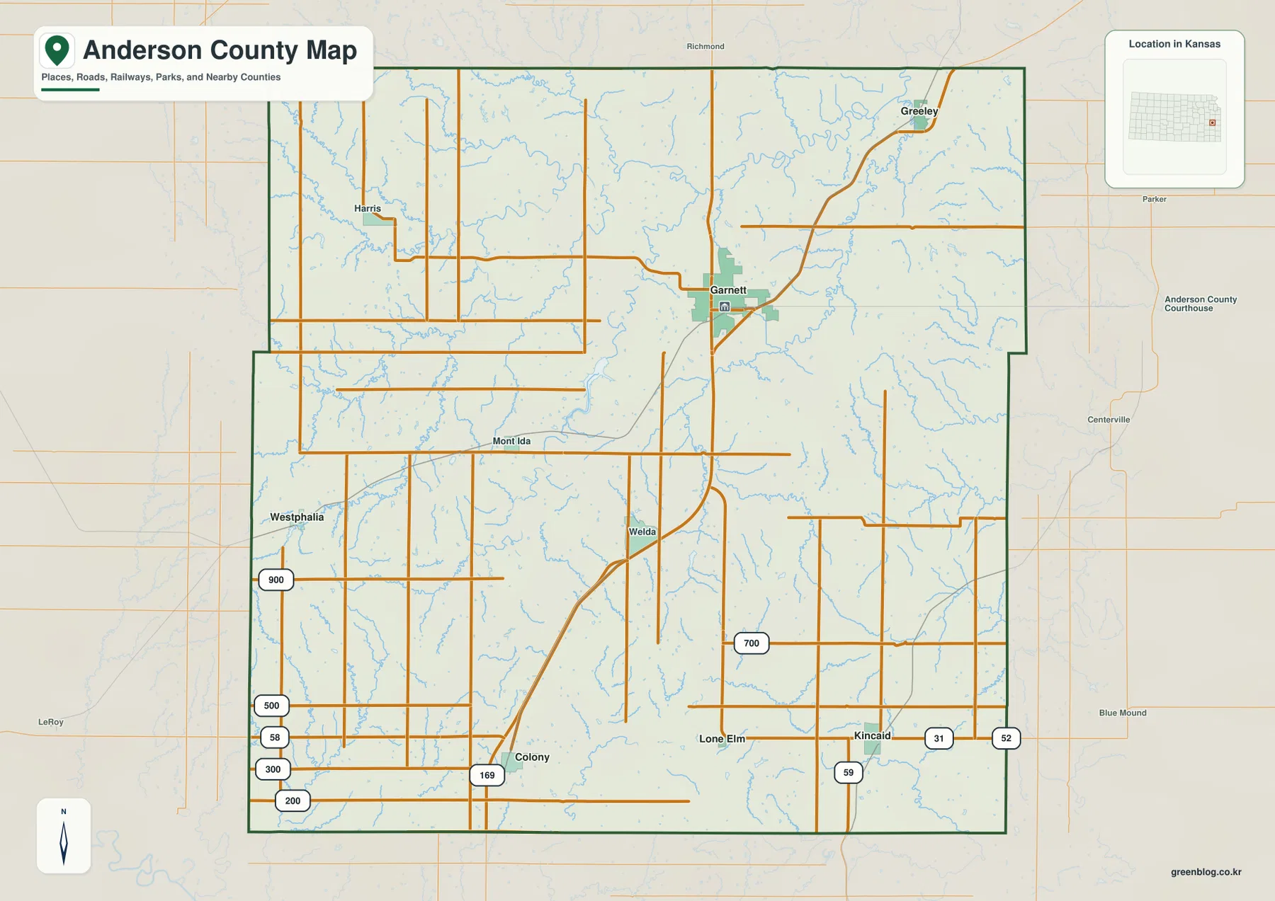
Nearby places outside the boundary also help establish orientation. Richmond appears north of the county, Parker and Centerville lie to the east, and LeRoy is southwest. These labels are useful when Anderson County is being compared with surrounding county maps because they show which side of the boundary leads toward familiar neighboring communities. The county outline is mostly regular, but small steps along the eastern side and corners keep it from being a perfect rectangle.
The general map includes many thin blue stream lines in addition to roads and place names. Around Garnett and throughout the western and southern townships, these small channels appear frequently, hinting at the dissected terrain that becomes much clearer on the water and elevation maps. For route planning or a first geographic overview, the general map is the most useful starting point. For river names, drainage direction, or relief, the specialized views remove enough road detail to make those patterns easier to follow.
A Settlement Pattern Spread from Garnett to the County Edges
The ranked city map simplifies the county to six principal communities. In the supplied index, Garnett is shown at 3,202, followed by Greeley at 243, Colony at 235, Kincaid at 188, Westphalia at 161, and Lone Elm at 40. These map labels are best used to compare relative prominence and spacing rather than as a substitute for a current official population estimate. Their main value is visual: the viewer can see immediately that one larger center is surrounded by much smaller communities in different corners of the county.
Garnett is north of the county’s geometric center, so the settlement pattern is not a simple hub with equal distances in every direction. Greeley sits well to the northeast, Colony is southwest, and Kincaid with Lone Elm occupies the southeastern part of the county. Westphalia lies close to the western boundary. The result is a broad geographic spread in which the smaller towns represent different parts of Anderson County rather than one continuous suburban or highway corridor.
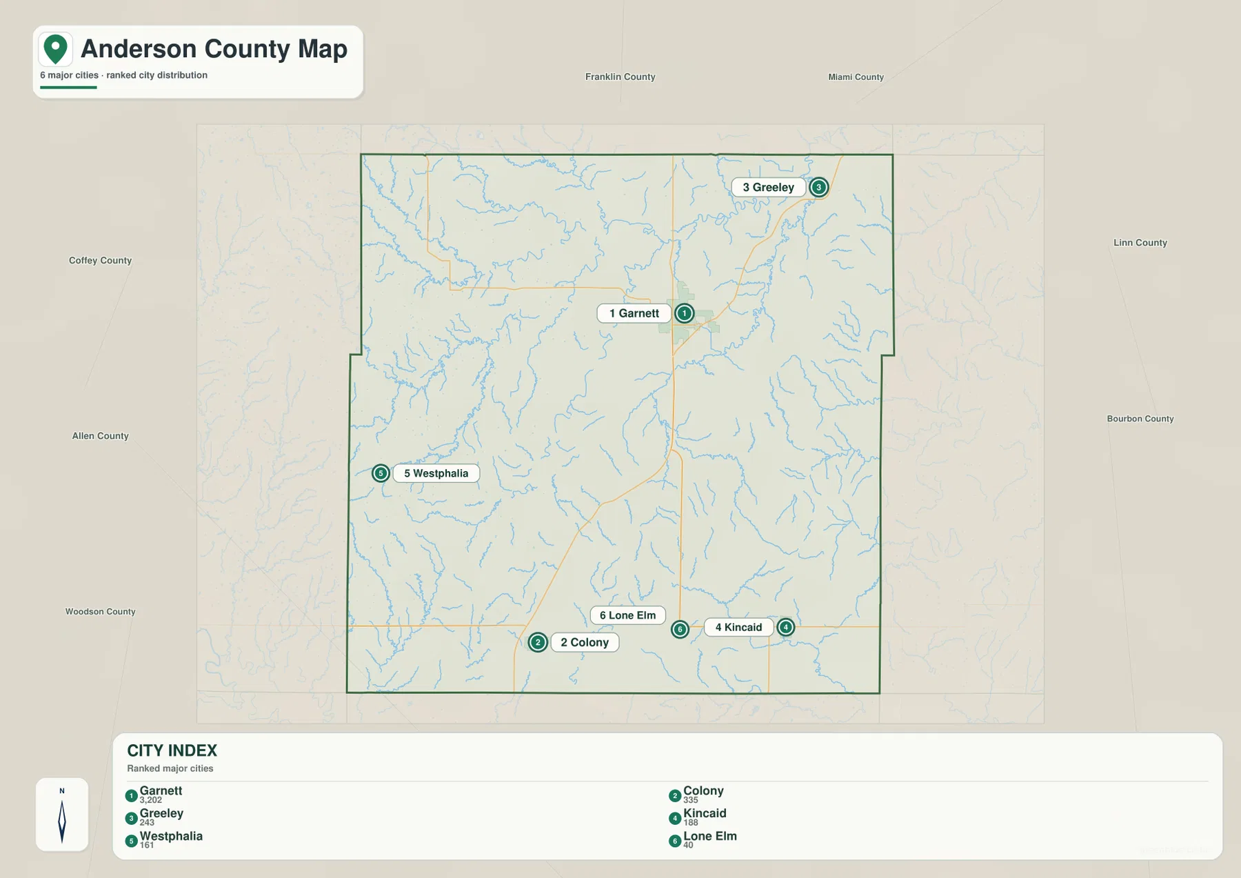
The surrounding county names make that spread easier to interpret. Franklin and Miami Counties are along the northern side, Linn and Bourbon are to the east, Allen and Woodson lie to the southwest and west, and Coffey County is northwest. Colony’s position places it close to the Allen–Woodson side of the region, while Kincaid is much nearer the Bourbon side. Greeley, by contrast, is tied geographically to the northeastern boundary. This context is helpful when building a larger sequence of Kansas county maps.
U.S. 169 creates a clear road relationship among Colony, Garnett, and the northeastern part of the county, but it does not explain every settlement. Westphalia and Kincaid rely on different local connections, and Lone Elm appears as a very small southeastern place separated from the main highway center. For classroom use, the city map is therefore best paired with the general map: one shows spacing and relative size cleanly, while the other restores the roads needed to understand how those places connect.
Pottawatomie Creek, Tributary Valleys, and a Chain of Small Lakes
The terrain-and-water map shifts attention away from highways and makes the northern drainage network the dominant feature. Pottawatomie Creek crosses the western and northern interior, collecting smaller channels as it moves across the county. Farther east, South Fork Pottawatomie Creek forms a long, winding corridor through the northeastern part of the map. Lake Garnett and Crystal Lake sit between major branches of this system, giving the Garnett area several useful water landmarks as well as its road connections.
Thomas Creek runs through the western interior, while Cedar Creek and Fish Creek cut across the central part of the county. Sugar Creek appears in the east, and Deer Creek drains part of the southern area. Near the southeastern edge, the North Fork Little Osage River becomes the important named feature. The pattern shows that Anderson County is divided among several local drainage directions rather than sending every stream into one obvious trunk river inside the county.
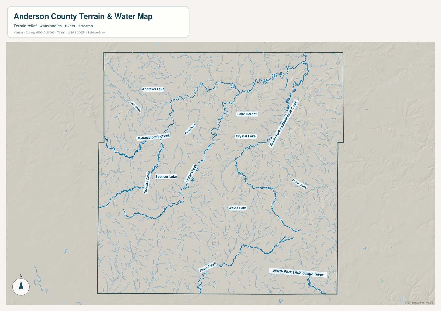
Several named lakes provide compact geographic markers. Andrews Lake is in the northwest, Lake Garnett is near the northern interior, Crystal Lake lies a short distance to its southeast, Spencer Lake is farther west, and Welda Lake appears in the south. None dominates the county at this scale, but together they make it easier to connect the hydrography map with towns and roads. Lake Garnett is particularly useful because its location is close enough to Garnett to connect a recognizable city with the surrounding creek network.
This water map is a geographic reference, not a flood-hazard, parcel, access-rights, or legal drainage map. Stream conditions can change with rainfall and season, and small channels may be intermittent or difficult to see on the ground. Its strength is county-scale structure: the Pottawatomie branches occupy the north, Thomas and Cedar Creeks cut through the interior, and the southern drainage includes Deer Creek and the North Fork Little Osage system. Those relationships become even clearer when compared with elevation.
From 263 to 371 Meters: Low Northeastern Valleys and Southern Uplands
The supplied elevation surface reports an actual range of roughly 263 to 371 meters and a mean near 318 meters. The lowest green tones occupy broad corridors in the north and especially the northeast, matching the major creek valleys. Tan and brown colors become more prominent across the southern and southeastern interior, where ridges and narrow tributary valleys create a much more textured surface. The map makes the county look considerably less flat than the road map alone might suggest.
Garnett sits near a useful transition between the lower Pottawatomie drainage and higher ground farther south. Moving toward Greeley follows generally lower valley terrain, while the Welda and Kincaid portions of the county include more frequent ridges and dissected uplands. The west is not uniformly low either; higher patches occur near the northwestern and southwestern edges. Anderson County therefore cannot be reduced to one steady slope from one border to another.
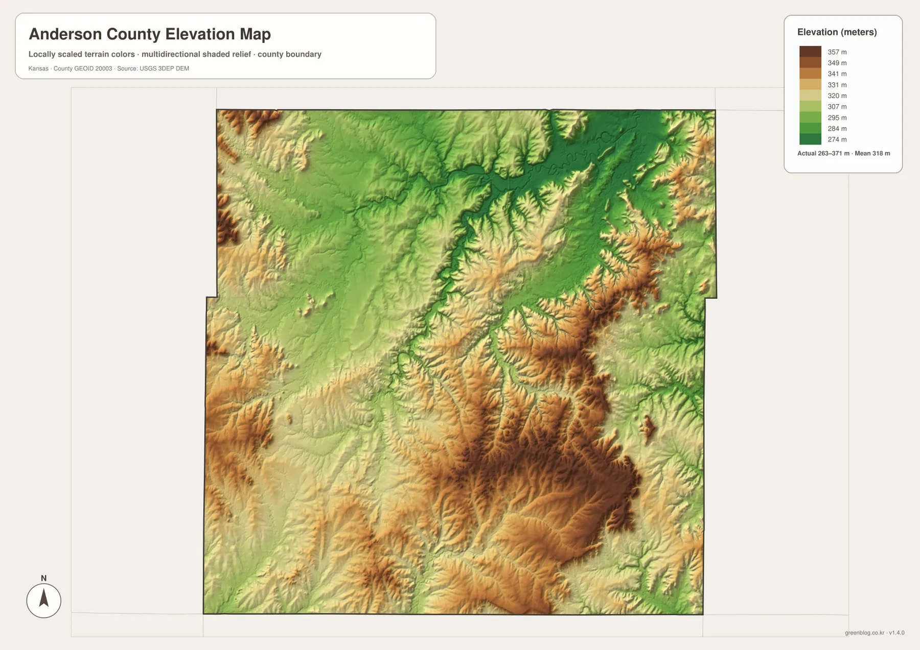
Placing the water and elevation views side by side shows why the green low bands have their shapes. Pottawatomie Creek and South Fork Pottawatomie Creek occupy the broadest low corridors, while Cedar Creek, Deer Creek, and other tributaries cut narrow paths into higher ground. The ridges between those channels create multiple local divides. This is a more accurate picture than assuming that all of eastern Kansas is a smooth plain at one elevation.
The elevation colors represent generalized county-scale terrain, not survey-grade measurements. They are useful for comparing valleys and uplands, understanding why streams follow particular corridors, and preparing regional geography material. They should not be used to determine the precise height of a building lot, road grade, property corner, or engineering project. For those tasks, detailed official survey or engineering data is necessary.
Lake Garnett as a Cross-Map Reference Point
Lake Garnett is a useful place to compare the map layers because it sits near the county’s best-known city and within the northern drainage network. The general map establishes Garnett and U.S. 169 first. The water map then shifts the focus toward nearby lakes and the Pottawatomie system, while the elevation view shows how the city lies near a transition from lower valley terrain toward higher ground to the south. Using one recognizable location across all four maps prevents the information from feeling like four unrelated diagrams.
Travel Kansas describes the Prairie Spirit Trail State Park as running north–south through Garnett and passing Lake Garnett before continuing toward downtown. That local context helps explain why the lake is more than a small blue symbol on a county map: it is part of the city’s recognizable recreation landscape. The map on this page does not provide detailed trail routing or current facility status, so visitors planning a trip should use the official tourism or park information for those details.
South of Garnett, the comparison changes. Welda and Colony remain connected to the U.S. 169 corridor, but nearby streams and relief become more dissected. Welda Lake and Deer Creek sit among higher ridges, and the southeastern Kincaid area also alternates between elevated ground and narrow drainage valleys. These features show why straight-line distance alone does not describe the county well: roads cross a landscape shaped by many small creeks and ridges.
Greeley provides the northeastern contrast. On the city map it is simply the second-ranked settlement and a point near the edge of the county. On the water and elevation maps, however, the surrounding area belongs to a broad low drainage setting associated with South Fork Pottawatomie Creek. That landscape is visibly different from the higher, more rugged-looking terrain around Kincaid in the southeast. Comparing those two places gives a clear sense of the county’s internal geographic variety.
Choosing the Best Map and Using the High-Resolution Files
For overall orientation, the general county map is the strongest starting point because it combines Garnett, smaller communities, U.S. 169, local routes, the boundary, and minor streams. The city distribution map is better when the main question is how Garnett compares with Greeley, Colony, Kincaid, Westphalia, and Lone Elm in size and location. It removes most road detail so the settlement pattern is immediately visible.
The terrain-and-water map is the right choice for Pottawatomie Creek, South Fork Pottawatomie Creek, Lake Garnett, Cedar Creek, Thomas Creek, Deer Creek, and other named water features. The elevation map removes most labels and emphasizes the broad contrast between low northern and northeastern valleys and the higher southern and eastern uplands. Pairing those two physical maps is especially useful for explaining why stream channels align with particular low corridors.
The WebP images embedded in the page are efficient for quick browsing, but small place and road labels can be difficult to inspect at normal screen size. The downloadable ZIP contains the high-resolution JPG originals corresponding to the general, city distribution, terrain-and-water, and elevation maps. Each JPG is 3638 × 2572 pixels, making the originals more practical for enlarged viewing, personal reference, or printing.
These maps are designed for general geographic understanding, not legal boundary work, live road navigation, flood certification, or engineering design. When a task requires current or authoritative details, use Anderson County, the U.S. Census Bureau, USGS, or another responsible agency alongside the map set. The advantage of the four-file collection is that readers can select the view that matches a question instead of forcing roads, cities, hydrography, and relief into one overcrowded image.
Frequently Asked Questions
Which map is best for comparing Garnett with Greeley, Colony, and Kincaid?
Use the ranked city map first when the goal is a quick comparison of settlement size and spacing. Add the general county map when you need to see how those places connect by road. U.S. 169 gives a particularly clear relationship among the Colony area, Garnett, and the northeastern side of Anderson County.
Where is the strongest elevation contrast in Anderson County?
The clearest county-scale contrast is between the low Pottawatomie Creek corridors in the north and northeast and the higher, more dissected uplands in the south and east. The supplied surface ranges from about 263 to 371 meters, with a mean near 318 meters. Tributary valleys cut back into the high ground, so no single half of the county has one uniform elevation.
Can the creek map be used for flood or property-boundary decisions?
No. It is a general reference showing features such as Pottawatomie Creek, South Fork Pottawatomie Creek, Cedar Creek, Thomas Creek, Deer Creek, and the named lakes. Current flood conditions, legal property boundaries, drainage rights, access, and road status should be checked with USGS, Anderson County, and other responsible agencies.
Map File Information
The ZIP contains the high-resolution JPG originals corresponding to the Anderson County general, city distribution, terrain-and-water, and elevation maps shown on this page.
- File Type: ZIP containing 4 JPG files
Related Maps
Sources and References
For county government and local context, see the official Anderson County website. Garnett and Lake Garnett context is available through Travel Kansas. Boundary and base geography can be checked through the U.S. Census Bureau TIGER/Line files, water features through USGS National Hydrography, and terrain through the USGS 3D Elevation Program.
Green Map creates custom-edited map images using open geographic data sources such as geoBoundaries, Natural Earth, OpenStreetMap, and government open data.
These maps are edited visual materials, not raw data files, and are provided for education, documents, presentations, and graphic reference.