Clinton County sits along the eastern edge of Iowa, where the Mississippi River forms the county’s most obvious physical boundary. Clinton and Camanche occupy the river side of the county, while DeWitt provides a strong inland reference point. U.S. 30 crosses the county from the Wheatland and Calamus side through Grand Mound and DeWitt toward the Clinton–Camanche area, and U.S. 61 runs north-south through DeWitt. The maps on this page show roads, major communities, named waterways, and elevation, and the same map set is also available as higher-resolution JPG files in a downloadable ZIP.
The county changes character as you move from west to east. Smaller communities and a wider rural road pattern dominate the western half, DeWitt anchors the middle, and the most urban-looking area appears along the Mississippi near Clinton and Camanche. The terrain-and-water map adds another layer by showing the Wapsipinicon River, Deep Creek, Silver Creek, Brophy Creek, Mill Creek, and several lakes. The elevation map then explains why the river edge and stream valleys look different from the higher ground to the north and west. Reading those themes together gives a much clearer sense of Clinton County than any one map can provide by itself.
Table of Contents
Follow U.S. 30 from the western towns to the Mississippi side
U.S. 30 is the easiest line to use when orienting yourself on the standard county map. It enters from the west near Wheatland and Calamus, continues by Grand Mound, passes through DeWitt, and then runs east toward Low Moor and the Clinton–Camanche area. That single route links several of the places most readers are likely to look for, so it works well as a first reference before adding the smaller roads. Instead of trying to memorize every label at once, start with U.S. 30 and use it to divide the county into west, central, and river-side sections.
DeWitt becomes even easier to place because U.S. 61 crosses the county north-south through the same area. Northwest of there, Iowa 136 reaches the Lost Nation side and continues toward Delmar. Charlotte and Goose Lake are shown farther northeast, while U.S. 67 appears close to the Mississippi side near Clinton. Road density increases around Clinton and Camanche, which matches the larger developed areas shown on the map. The purpose of this map is geographic orientation rather than live navigation, so closures, construction, turning restrictions, and current travel times should always be checked with an up-to-date road source.

The eastern county edge is visually different from the rest of the boundary because the Mississippi River runs alongside it. Clinton and Camanche sit close to that river, while the road network spreads westward toward DeWitt and the smaller communities. The boundary and road lines are useful for understanding relative position, but they are not parcel lines or a legal property survey. If an exact property boundary, right-of-way, or legal jurisdiction is important, consult the current county or agency records rather than relying on this general reference map.
Six city markers show the county’s east-west settlement pattern
The city map highlights Clinton, DeWitt, Camanche, Wheatland, Grand Mound, and Delmar. Clinton is the dominant marker on the Mississippi side, with Camanche just to the south. DeWitt sits well inland and becomes the main central reference. Grand Mound and Wheatland extend the city pattern westward, while Delmar is separated to the north. The result is an easy-to-read overview in which the large river-side city is balanced by smaller communities spread across the rest of the county.
This version is especially useful when the standard road map feels crowded. It removes much of the road detail and makes the relative positions of the six communities easier to remember. Once those locations are familiar, the standard map explains how they connect: U.S. 30 links the western side through DeWitt toward the river, while U.S. 61 provides the strongest north-south reference through the central part of the county. Moving back and forth between the two maps is more useful than treating them as duplicate views because one emphasizes settlement and the other emphasizes transportation.
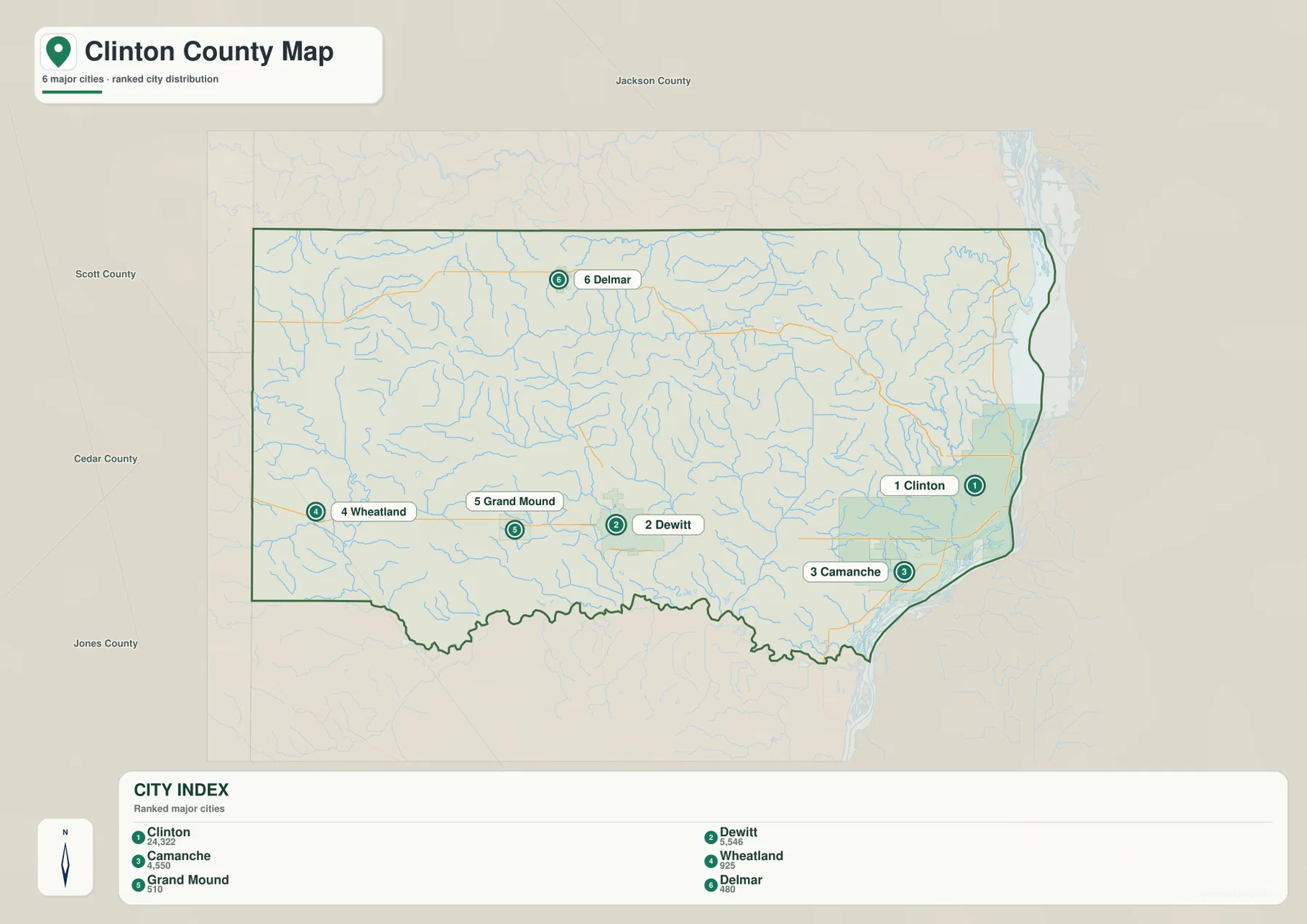
The outer labels also help place Clinton County within eastern Iowa, but the most useful information here is the distribution inside the county itself. The Mississippi-side communities are close together, DeWitt occupies a separate inland position, and the western and northern communities are more widely spaced. The map should not be used to estimate driving mileage by eye. Road distance, travel time, and the best route can differ considerably from the straight map view, especially where a river, local road network, or bridge determines the practical path.
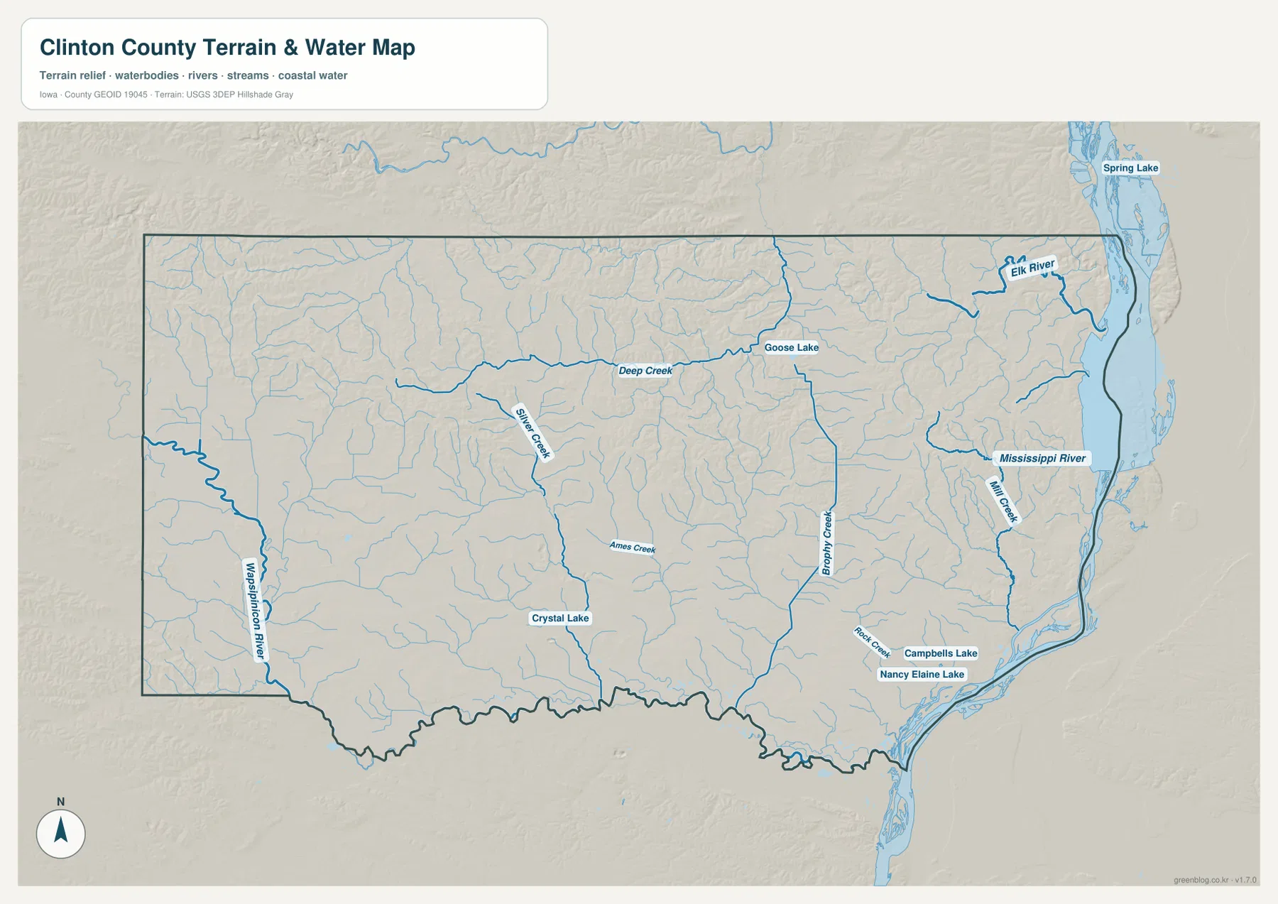
The Mississippi and Wapsipinicon frame two very different water settings
The Mississippi River is the most prominent feature on the terrain-and-water map. It runs along the eastern side of Clinton County and widens beside the Clinton and Camanche area, where channels and river water occupy a large part of the map edge. Inland streams are smaller but much more numerous. The Elk River appears in the northeast, and Mill Creek reaches toward the Mississippi side closer to Clinton. The water map makes it immediately clear that the eastern urban area is not simply near a county line; it is directly tied to a major river corridor.
A second strong water reference appears in the southwest, where the Wapsipinicon River reaches the county edge and follows the lower part of the map. Farther north and east, Deep Creek, Silver Creek, and Brophy Creek form long named branches across the interior. Numerous smaller tributaries fill the spaces between them. That dense network is easy to miss on the road map, but it explains why the shaded terrain contains so many small valleys. A useful way to read the water map is to find one named creek first and then follow the lighter tributary lines that join it.
Several lakes add local reference points. Goose Lake appears toward the north, Crystal Lake is shown farther southwest of center, and Campbells Lake and Nancy Elaine Lake sit near the southeastern river side. Spring Lake is labeled outside the county across the Mississippi corridor, providing additional context for the river landscape. These labels are for location and general geographic understanding. The map is not a flood-hazard map, navigation chart, depth map, fishing-regulation map, or property-access guide, so any decision involving water safety or regulation should use the responsible agency’s current information.
A 123–290 meter range separates river lowlands from higher northern ground
The elevation map gives Clinton County an actual displayed range of about 123 to 290 meters, with a mean of 219 meters. The lowest dark-green terrain follows the Mississippi River along the eastern edge, producing a continuous low corridor beside Clinton and Camanche. Lower ground also reaches inland along stream valleys. When the elevation map is compared with the terrain-and-water map, several green bands line up with named drainage routes, making the relationship between streams and local relief easy to see.
The higher colors are concentrated most strongly across northern and northwestern parts of the county. Brown and tan ridges are cut by narrow greener valleys, and similar elevated blocks appear between stream corridors elsewhere. The contrast with the Mississippi side is substantial enough to change the visual character of the county from east to west. Clinton County therefore should not be imagined as one perfectly flat surface. Broad uplands, rolling high ground, creek valleys, and the much lower river edge all appear within the same county-scale view.
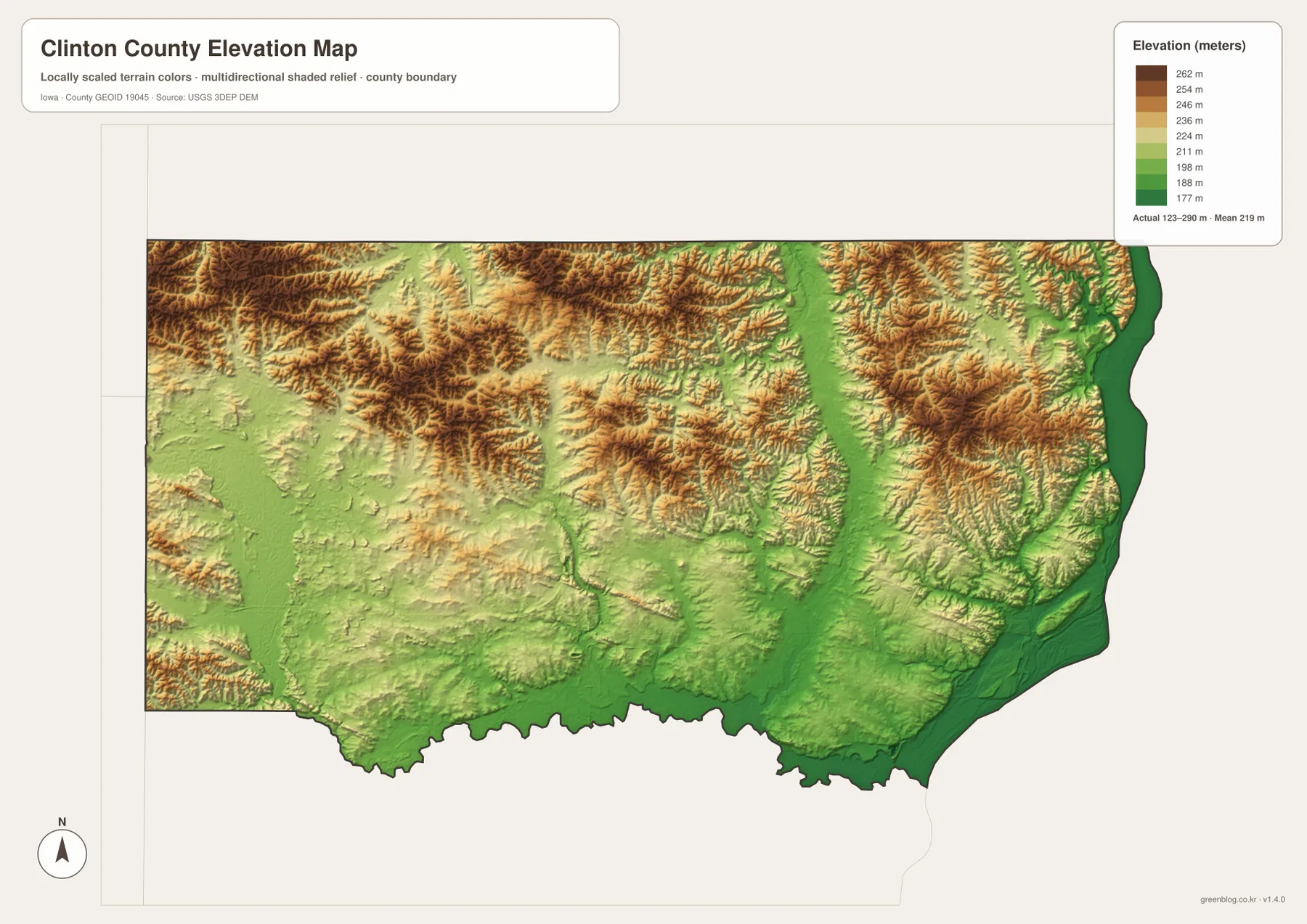
The color surface is intended for broad comparison rather than site-level measurement. A farm field, building lot, road project, drainage design, or survey may require much more precise data than this map can show. Even within one color band, actual elevations continue to change. Use this map to understand the main contrast between the river lowlands, creek valleys, and surrounding uplands, and use original USGS elevation data or a professional survey when an exact elevation is required.
Roads, towns, and valleys all reinforce the county’s east-west contrast
Clinton County becomes easier to understand when the map themes are compared in the same order. The standard map uses U.S. 30 to connect Wheatland, Grand Mound, DeWitt, and the river-side area. The city map shows the largest population center concentrated near the Mississippi while smaller communities spread inland. The water map replaces the road emphasis with a broad river edge and a dense interior creek network. Finally, the elevation map shows the Mississippi corridor as the lowest continuous strip and leaves much of the northern and western side at higher elevations.
DeWitt is a practical midpoint for that comparison. It sits inland on the road map near the U.S. 30 and U.S. 61 crossing, appears as one of the major city markers, and lies between the higher western and northern terrain and the lower Mississippi side. From DeWitt, moving east on U.S. 30 brings the reader toward Low Moor, Camanche, and Clinton; moving west brings Grand Mound, Calamus, and Wheatland into view. Once that route is familiar, the water and elevation maps reveal how many stream valleys lie around the same transportation corridor.
Clinton and Camanche provide the opposite reference. Their developed areas appear close together near the eastern edge, the water map places the Mississippi immediately beside them, and the elevation map marks that river corridor in its lowest tones. Seeing the same place repeated across transportation, settlement, water, and elevation themes helps turn the county from a collection of labels into a coherent landscape. That is often more useful than trying to remember every road or creek independently.
County park information adds real-world context to the two river corridors
Clinton County’s official Conservation pages provide useful context for some of the water features seen on the maps. Sherman Park is described as a county park along the Wapsipinicon River, while Rock Creek Campground and Marina is listed near Camanche on the eastern river side. Those official references make the map easier to connect with real places: the Wapsipinicon corridor in the southwest is not just a line on the water map, and the Mississippi side near Camanche includes active county recreation facilities tied to the river setting.
The map should still be separated from current visitor information. Park access, seasonal operations, boating conditions, temporary closures, and flood-related changes can vary, so the county’s current Conservation pages are the better source for a visit. A good workflow is to use the maps here for overall orientation, then check the official park information for the latest details. This is especially important around large rivers, where water conditions and facility access can change more quickly than a static reference map.
Choose the map that matches the question you are trying to answer
For a first look at Clinton County, begin with the standard map and locate Clinton, DeWitt, and U.S. 30. Those three references quickly establish the eastern river side, the inland center, and the main east-west route. The city map is the next useful step when the goal is to compare Camanche, Wheatland, Grand Mound, and Delmar without the distraction of minor roads. If you start with the city map instead, return to the standard map afterward to see how the communities connect through the highway network.
For rivers, lakes, and creeks, the terrain-and-water map is the most direct choice. Start with the Mississippi and Wapsipinicon rivers, then trace Deep Creek, Silver Creek, Brophy Creek, Mill Creek, and the smaller branches around them. If the next question is why some of those valleys stand out so clearly, switch to the elevation map. The low Mississippi corridor and the greener creek valleys can then be compared with the higher northern and western ground.
The WebP images in the article are convenient for browser viewing. For printing, classroom work, presentations, or offline reference, use the higher-resolution JPG files in the ZIP below. The archive contains separate standard county, city, terrain-and-water, and elevation maps so you can use only the image that fits the task. These remain general reference maps rather than legal-boundary, live-traffic, flood-regulation, engineering, or survey products, and an authoritative current source should be used whenever a decision depends on exact conditions.
Frequently Asked Questions
Which map is best for seeing Clinton and Camanche beside the Mississippi River?
The standard county map is the quickest choice when you want the cities and road network together. It places Clinton and Camanche along the eastern edge, shows U.S. 30 approaching the river-side area, and includes U.S. 67 near Clinton. If the river itself is the main subject, follow with the terrain-and-water map, which shows the Mississippi corridor, Mill Creek, Rock Creek, nearby lakes, and the broader drainage setting.
What is the simplest reference for finding DeWitt and the western communities?
Use U.S. 30 as the main east-west reference. DeWitt sits where U.S. 61 also provides a north-south line, while Grand Mound, Calamus, and Wheatland extend westward along or near the U.S. 30 corridor. The city map is useful for learning the relative positions first, and the standard map then adds the road detail needed to understand how the communities connect.
Where are the lowest and highest areas on the elevation map?
The lowest dark-green ground follows the Mississippi River along the eastern county edge, with additional lower corridors along creek valleys. The highest brown and tan terrain is most extensive in the northern and northwestern parts of the county. The displayed county range is about 123 to 290 meters with a mean of 219 meters, but the map is designed for broad comparison rather than exact site elevation.
Map File Information
Download high-resolution JPG versions of the Clinton County standard map, major-city map, terrain-and-water map, and elevation map in one ZIP archive.
- Included Files: 4 high-resolution JPG maps
Related Maps
Sources and references
These official sources provide county information and background for the boundary, hydrography, and elevation data used for geographic reference. For changing park access, administrative information, or other current conditions, check the responsible agency’s latest page.
- Official Clinton County, Iowa website
- Clinton County Conservation parks
- U.S. Census Bureau TIGER/Line Shapefiles
- USGS National Hydrography
- USGS 3D Elevation Program
These maps are intended for general geographic orientation. Current road restrictions, legal boundaries, property ownership, flood regulation, and precise elevation should be confirmed with the latest records or data from the responsible agency.
Green Map creates custom-edited map images using open geographic data sources such as geoBoundaries, Natural Earth, OpenStreetMap, and government open data.
These maps are edited visual materials, not raw data files, and are provided for education, documents, presentations, and graphic reference.