Cherokee County in northwestern Iowa is organized around the city of Cherokee, with smaller communities such as Marcus, Aurelia, Quimby, Cleghorn, and Washta spread across the county rather than concentrated in one corridor. The supplied maps show that this settlement pattern overlaps with several distinct river valleys, especially the Little Sioux River system through the central and eastern part of the county and the West Fork Little Sioux farther west. The elevation surface adds another layer by showing lower green river corridors between higher rolling uplands. The WebP images on this page are sized for quick viewing, and the original high-resolution JPG map files can be downloaded together in a ZIP for closer inspection or printing.
A useful way to orient yourself is to locate Cherokee first, then compare Marcus and Cleghorn to the west, Aurelia to the east, and Quimby and Washta to the south. The general map labels major route numbers including 3, 7, 31, 57, 59, and 143, which makes it easier to connect the towns without relying on a separate road atlas. On the natural-feature maps, the county’s terrain is not a single flat surface: the mapped elevation range is about 341 to 462 meters, with broad low valleys separated by higher ridges and rolling ground.
Table of Contents
Cherokee provides the central reference while towns spread toward every side
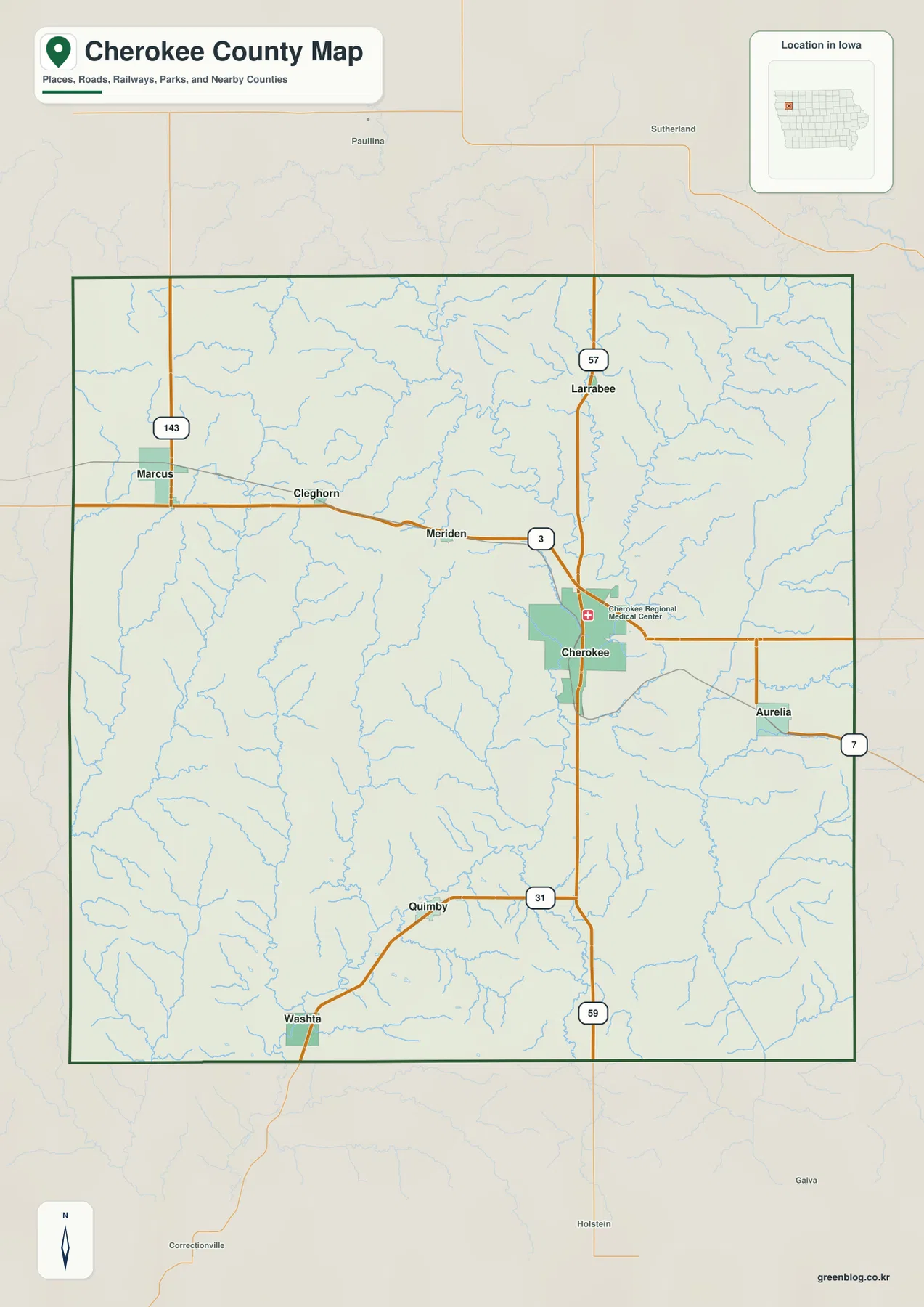
On the general county map, Cherokee sits slightly east of the county’s center and serves as the easiest reference point for the surrounding road network. Larrabee is north of the city near the route marked 57, while Meriden and Cleghorn lie to the west. Marcus is farther northwest near the route numbered 143. Aurelia is near the eastern side of the county, and Quimby and Washta are separated from Cherokee to the south and southwest. This arrangement makes the county feel less like a single north-south chain of towns and more like several small communities connected across a broad rural area.
The route numbers make those relationships easier to follow. A road marked 3 approaches Cherokee from the west, while the north-south route numbered 59 continues south from the Cherokee area. Route 31 appears near Quimby, route 7 near Aurelia, and route 143 near Marcus. Because the map is designed for county orientation rather than live navigation, it should not be used for current construction, closures, or turn-by-turn driving. Its value is in showing where the principal towns and numbered roads sit relative to one another and to the county boundary.
Places outside the county boundary also help with orientation. Paulina and Sutherland appear to the north, Holstein and Correctionville to the south, and Galva beyond the southeastern side. Marcus and Cleghorn are clearly closer to the western edge, while Aurelia is close to the east. Cherokee’s more central position becomes obvious when those outside reference points are included. The wide separation between the northern and southern communities also helps convey the scale of the county better than focusing on Cherokee alone.
The six highlighted cities form a northwest-to-southeast spread rather than one cluster
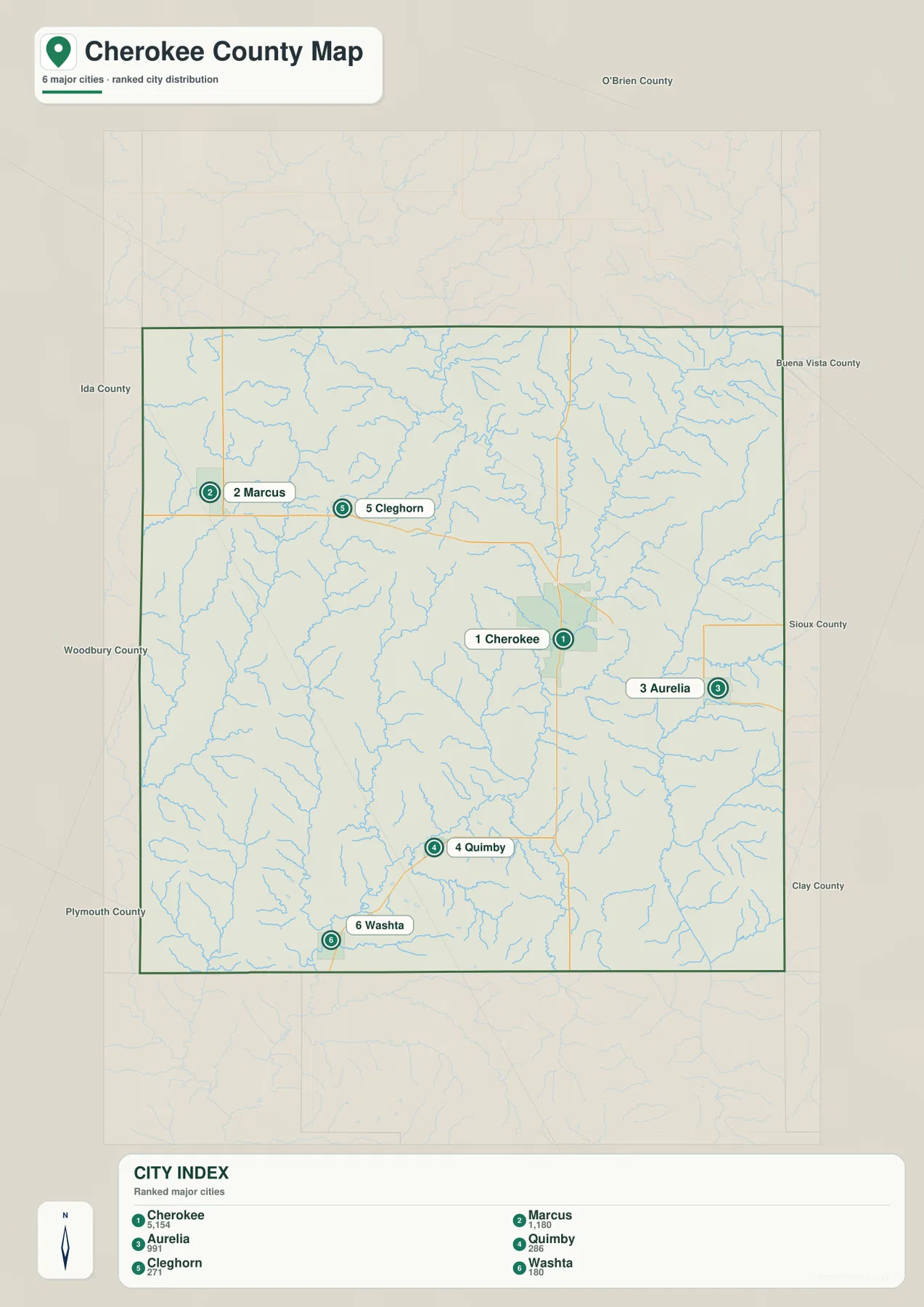
The city-distribution map highlights six places with ranking values. The labels on the supplied map show Cherokee at 5,154, Marcus at 1,180, Aurelia at 991, Quimby at 286, Cleghorn at 271, and Washta at 180. These are best treated as the values used in the map graphic rather than as a claim about the latest official population totals. Their main purpose here is to show the relative size and position of the highlighted communities. Cherokee is much larger than the other labeled cities, while Marcus and Aurelia form a second group and the remaining three are smaller.
The location pattern is just as useful as the ranking. Marcus occupies the northwest, Cleghorn sits west of center, Cherokee is east of center, Aurelia lies toward the southeast, Quimby is in the southern interior, and Washta is in the southwest. A line drawn between the six would cover much of the county rather than remaining within one small urbanized area. That wide spread is important when comparing the road map with the water and elevation maps, because each town sits near a somewhat different drainage and terrain setting.
Neighboring county labels on the city map include O’Brien, Buena Vista, Sioux, Clay, Plymouth, Woodbury, and Ida counties. Those names help show which highlighted towns are close to outer edges of Cherokee County. The six ranked cities are not meant to be a complete list of every place or community in the county. For a broader set of place names, the general map is the better choice, while the city map is most useful for quickly comparing the relative position of the selected centers.
Three large river corridors divide the interior into separate valleys
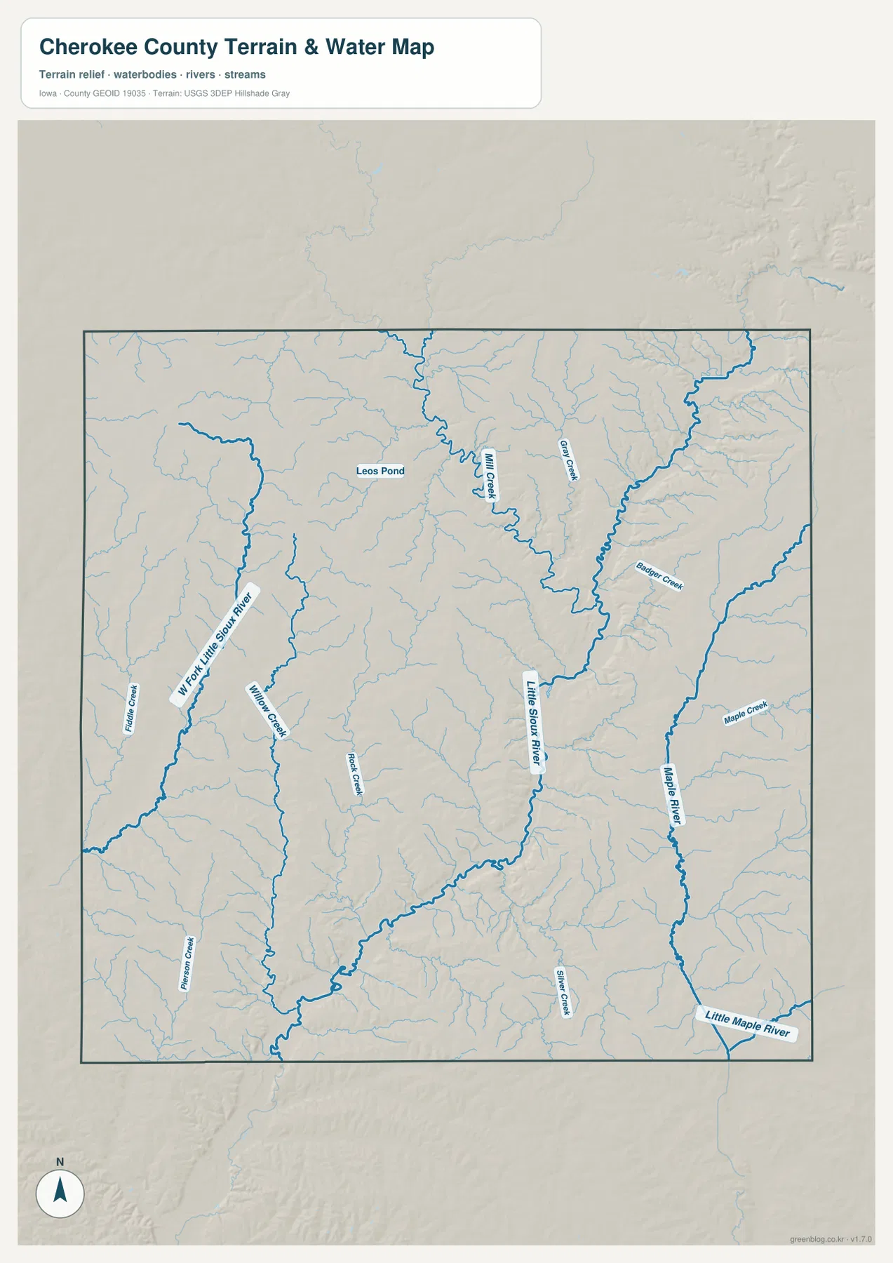
The terrain-and-water map shows that Cherokee County is crossed by several major drainage corridors rather than one dominant river alone. The Little Sioux River runs through the central and eastern interior, receiving many smaller tributaries as it continues south. Farther west, the W Fork Little Sioux River forms a separate valley. Willow Creek and Rock Creek occupy parts of the ground between the western fork and the central river system, creating additional smaller cuts through the rolling uplands.
The eastern side is organized around the Maple River. Its main channel follows a north-south course near the eastern part of the county, with Maple Creek and Badger Creek feeding into the local drainage network. The Little Maple River appears near the southeastern edge, while Silver Creek is labeled farther south. Comparing this side with the Little Sioux system makes it clear that the eastern lowlands belong to a different valley pattern than the broad low corridor around Cherokee.
Smaller named features add useful detail. Mill Creek and Gray Creek appear in the north, Leos Pond is labeled in the northwestern interior, and Fiddle Creek and Poison Creek occupy the western and southwestern parts of the map. These minor waterways explain many of the narrow valleys visible on the shaded relief. The map is not a flood-hazard, water-quality, or legal-boundary product, however, so those questions require the appropriate agency data rather than visual interpretation from this county overview.
Elevation spans about 341 to 462 meters, with the main rivers occupying the low green corridors
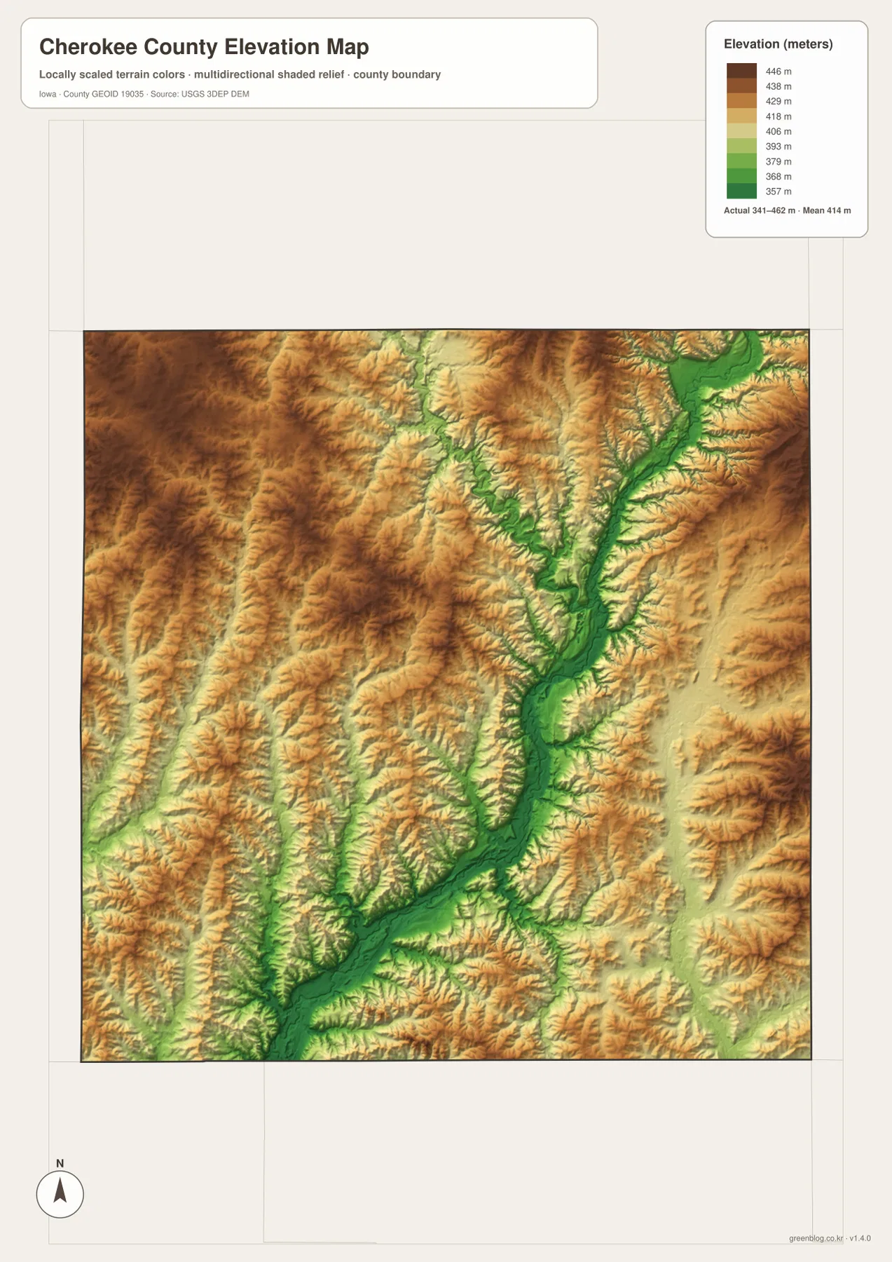
The elevation legend gives an actual county range of roughly 341 to 462 meters and a mean near 414 meters. Brown and dark tan represent the higher parts of the local surface, while green marks lower ground. Much of the western and northwestern county appears in the higher colors, but that upland is repeatedly cut by narrow tributary valleys. The result is rolling terrain with short ridges and drainage cuts rather than a smooth elevated plateau.
The most prominent low zone follows the Little Sioux River from the northeast through the central part of the county and southward. It appears as a broad green ribbon with smaller green branches entering from both sides. When the water and elevation maps are compared side by side, the relationship is immediate: many of the lowest areas correspond to the river and tributary valleys. Cherokee lies close to this major corridor, which helps explain why the city is a useful anchor for reading both the transportation and terrain maps.
A second lower corridor follows the Maple River along the eastern side, separated from the Little Sioux lowland by higher rolling ground. Higher terrain also reappears near portions of the eastern boundary, so the county cannot be described accurately as simply sloping from west to east. It is better understood as a set of uplands divided by several river systems. The colors are relative elevation classes only: green does not automatically mean wetland or floodplain, and brown does not imply mountainous terrain. Survey-grade decisions require the original elevation data and field measurements.
Comparing Cherokee with Marcus and Aurelia connects settlement, drainage, and relief
Using Cherokee as the middle reference and then looking northwest to Marcus and southeast to Aurelia is a practical way to connect all four maps. On the general map, Marcus sits close to the western boundary, Aurelia is close to the eastern side, and Cherokee occupies the space between them where several roads converge. The city map reinforces that pattern by ranking Cherokee first, with Marcus and Aurelia as the next two highlighted centers.
The water map adds a different relationship. Cherokee is associated with the broad Little Sioux River corridor, while the western side near Marcus is influenced by the West Fork Little Sioux and nearby tributaries. Around Aurelia, the eastern drainage network and Maple River system become more relevant. This gives each part of the county a different natural reference even though all three places belong to the same rural county road network.
The elevation surface makes the contrast stronger. Western ground around the Marcus side contains more high brown and tan colors, while the main Little Sioux valley near Cherokee is distinctly lower. The Aurelia side includes both lower drainage corridors and higher intervening ground. Finding the towns first and then switching from roads to water to elevation is often easier than starting with the terrain colors alone, because every low valley can then be tied back to a known location.
Use the road and city maps for orientation, then the water and elevation maps for terrain
If the main question is where a town or road lies, start with the general map. It includes Cherokee, Marcus, Aurelia, Quimby, Washta, Cleghorn, Meriden, Larrabee, several route numbers, and the county boundary in one view. The city map removes much of that extra detail and emphasizes the six ranked centers, so it works better for explaining the geographic spread of the larger communities. Using both avoids treating the simplified city ranking as a complete place-name map.
For natural features, locate the Little Sioux River, West Fork Little Sioux River, and Maple River on the water map before opening the elevation surface. The green lowlands on the elevation map then become easier to interpret because they can be matched to specific river and creek valleys. This is especially helpful in Cherokee County, where several separate drainage systems divide higher rolling ground instead of one river valley controlling the whole county.
The WebP images in the article are reduced for normal web viewing. The download archive contains the original 3638 × 2572 pixel JPG versions of the general county, city distribution, terrain-and-water, and elevation maps. Those larger files are better for enlarging small labels, printing, or comparing the same county boundary across several subjects. They can be viewed individually or placed side by side when a road, stream, or ridge is easier to understand in more than one map.
Frequently Asked Questions
Which natural feature is most useful for orienting the Cherokee area?
The Little Sioux River valley is the clearest natural reference on the supplied maps. The terrain-and-water map shows the main river corridor passing through the central and eastern interior, while the elevation map shows a broad green lowland in the same area. Cherokee lies close to that corridor, making the river valley useful for connecting city location with terrain.
What is the fastest way to compare Marcus and Aurelia?
Use the city-distribution map first. Marcus is highlighted in the northwest and Aurelia in the southeast, with Cherokee between them. If you also need road context, switch to the general map to compare the route marked 143 near Marcus with the route marked 7 near Aurelia and the roads converging around Cherokee.
Do the green areas on the elevation map mean floodplain or wetland?
No. Green indicates lower elevation relative to the rest of Cherokee County within the mapped range of about 341 to 462 meters. Many green areas follow river and creek valleys, but the color alone does not classify flood hazard, wetland status, or development suitability. Those questions require separate authoritative datasets.
Map File Information
The original high-resolution JPG files are bundled in one ZIP for closer viewing, printing, and comparison of Cherokee County roads, cities, waterways, terrain, and elevation.
- Printable Size: 2572 × 3638 px
- File Type: JPG
Related Maps
Sources and references
These resources provide additional Cherokee County conservation context and official data references for boundaries, hydrography, and elevation.
- Cherokee County Conservation Board
- Cherokee County Conservation Board – Parks
- Iowa DNR – Nestor Stiles Prairie State Preserve
- U.S. Census Bureau TIGER/Line Shapefiles
- USGS National Hydrography
- USGS 3D Elevation Program
Green Map creates custom-edited map images using open geographic data sources such as geoBoundaries, Natural Earth, OpenStreetMap, and government open data.
These maps are edited visual materials, not raw data files, and are provided for education, documents, presentations, and graphic reference.