Calhoun County sits in west-central Iowa, with Rockwell City near the middle of the county and smaller communities spread well beyond it. U.S. 20 crosses the northern half, Iowa 4 provides a strong north-south reference, and Iowa 175 helps locate Lake City and the southern communities. The natural map is just as useful: Twin Lakes stands out in the north, while the North Raccoon River occupies a much lower valley in the southwest. This page brings those features together with a county reference map, a ranked city map, a terrain-and-water map, and an elevation map. High-resolution JPG versions are also available in the download package for printing or close inspection.
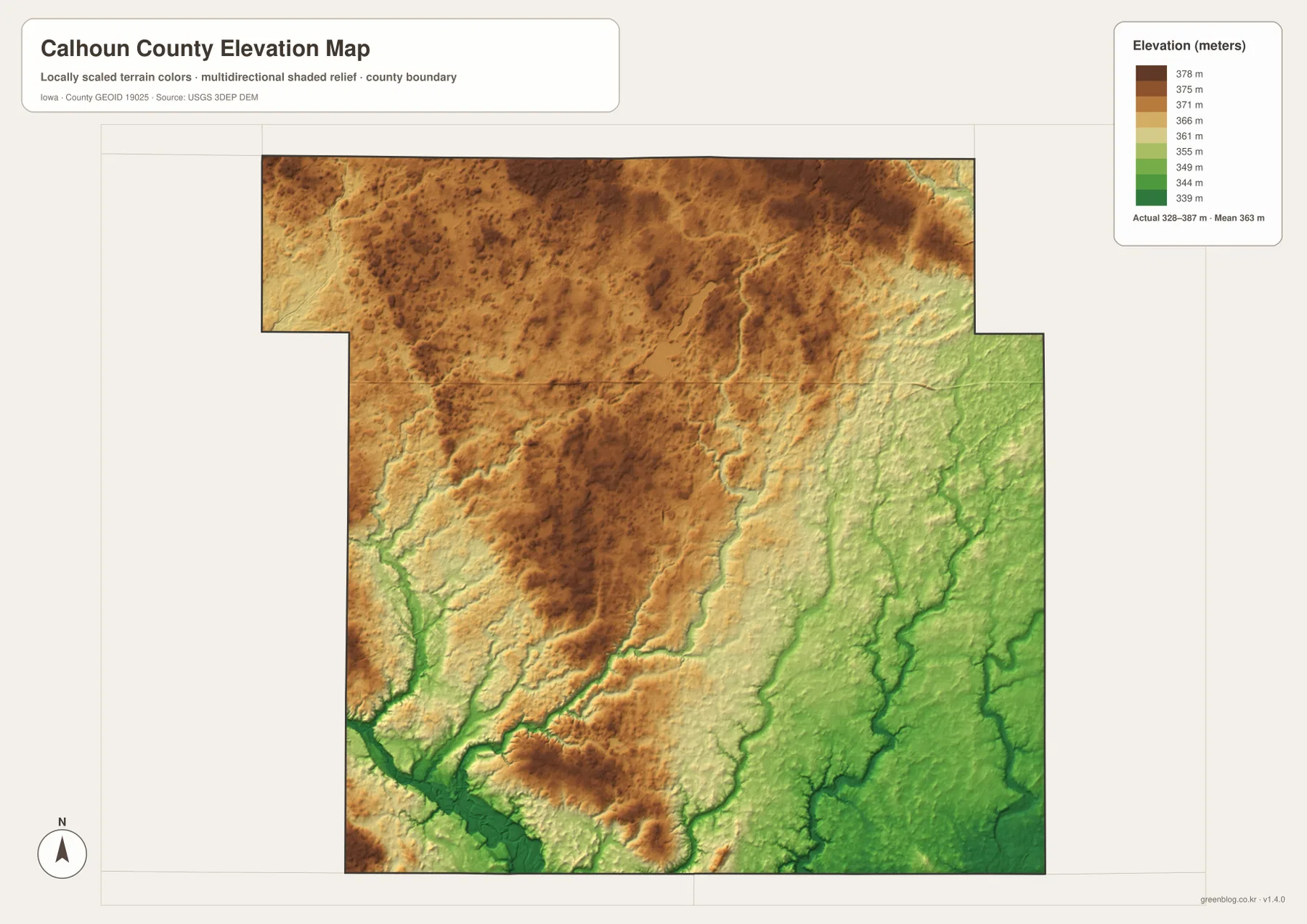
The county is not uniformly flat when viewed at this scale. The elevation layer shows broad higher ground across much of the north and west-central area, then lower terrain toward the southeast and along the North Raccoon River. Small creeks cut through the higher surface, creating shallow valleys that become easier to recognize when the water and elevation maps are compared side by side. Rockwell City is useful for orientation, Twin Lakes gives the north a clear landmark, and the river system in the southwest provides a second natural reference point.
Table of Contents
Start with Rockwell City, U.S. 20, and Iowa 4
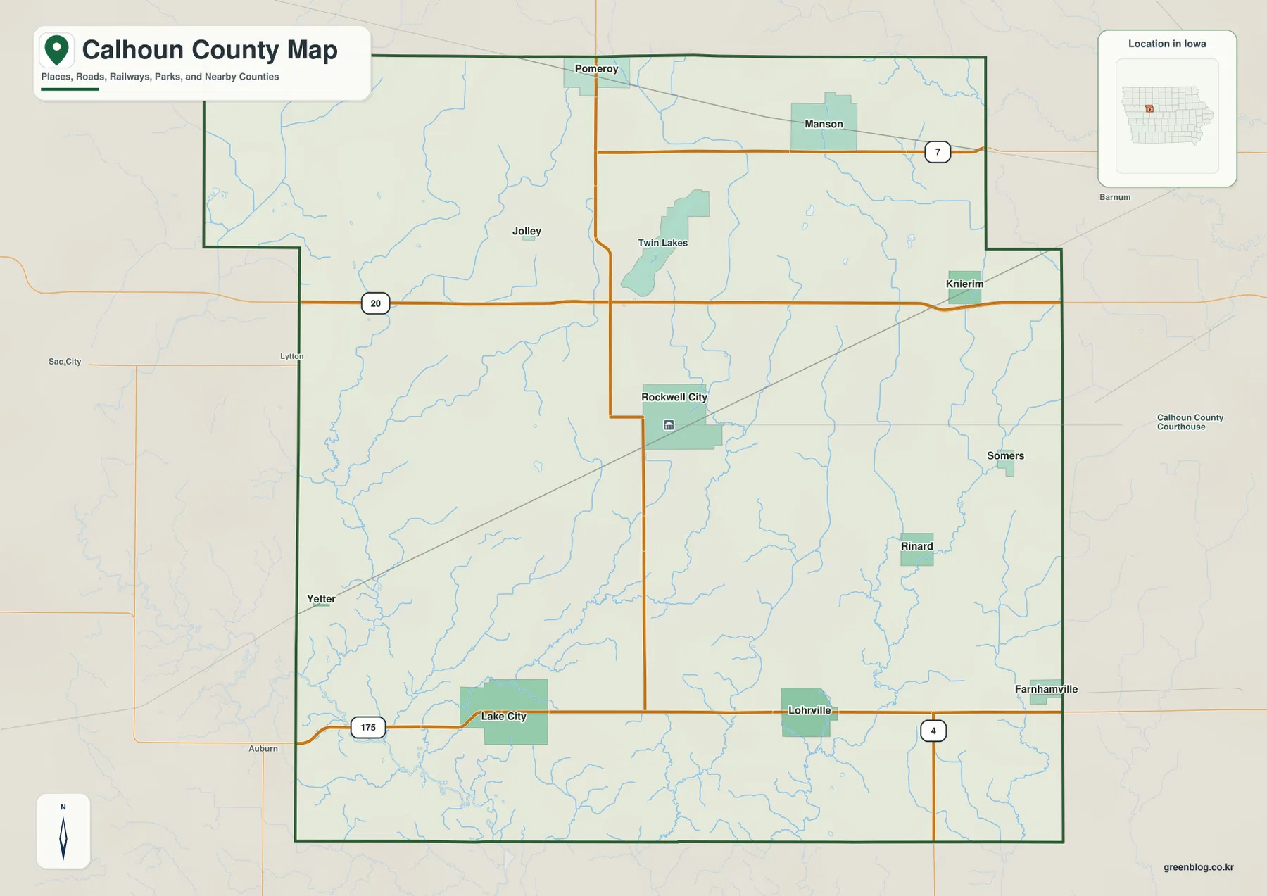
Rockwell City appears close to the center of the county and works well as the first point of reference. Iowa 4 runs north from the Rockwell City area toward Pomeroy, while U.S. 20 crosses the county farther north. Manson lies in the northeast near Iowa 7, and Lake City sits much farther southwest near Iowa 175. Once those roads and towns are located, the rest of the county becomes easier to divide into northern, southern, eastern, and western sections.
The reference map also shows how dispersed the smaller places are. Jolley is west of the Twin Lakes area, Knierim lies toward the northeast, and Somers and Rinard appear on the eastern side. Lohrville occupies the south-central part of the county, while Farnhamville is close to the southeastern edge. That pattern is important because Calhoun County does not revolve around one continuous urban corridor. Communities are separated by broad rural areas, and the major roads act as the most practical links between them.
U.S. 20 is especially helpful for understanding the upper half of the county. Iowa 175 does the same for the south, and Iowa 7 provides a useful route reference around Manson. These maps are intended for county-wide orientation rather than turn-by-turn navigation. They do not replace current highway conditions, construction notices, or detailed local road maps, but they make it much easier to see where major places and corridors sit relative to the county boundary.
The largest communities are separated rather than clustered
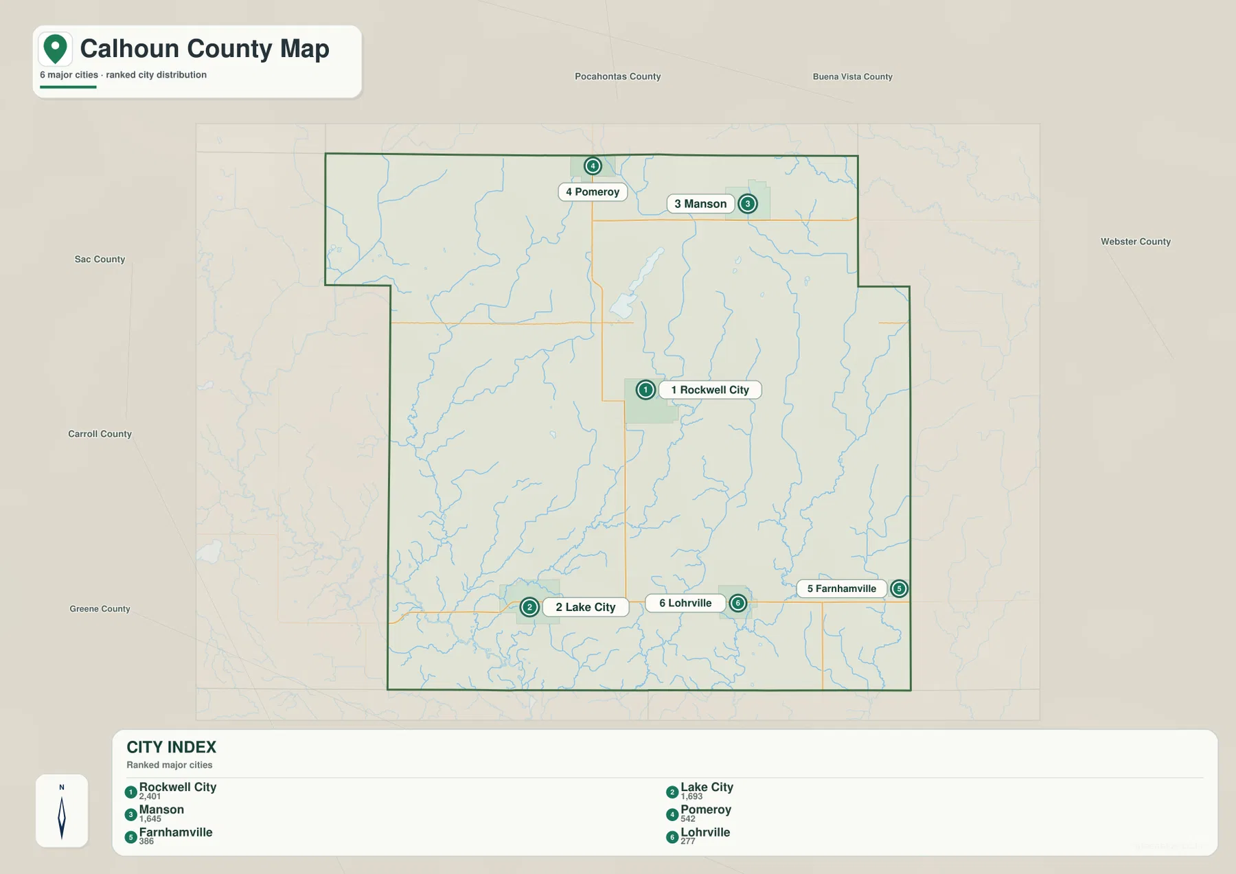
The city map ranks six major communities: Rockwell City, Lake City, Manson, Pomeroy, Farnhamville, and Lohrville. The values printed on the supplied map are 2,401 for Rockwell City, 1,693 for Lake City, 1,645 for Manson, 542 for Pomeroy, 386 for Farnhamville, and 277 for Lohrville. These are the comparison values embedded in the provided city map, not a new population estimate produced for this article. Anyone who needs a population for a specific year should check the latest Census release.
Location tells a more useful story than rank alone. Rockwell City is near the middle, but Lake City is well to the southwest and Manson is in the northeast. Pomeroy sits near the northern boundary, Farnhamville is close to the southeast, and Lohrville is in the southern part of the county. The major communities therefore form a wide spread across the map rather than a single urban cluster. That distribution helps explain why the county reference map needs several road corridors to make sense of everyday geography.
Each town also works as a landmark for a different part of the county. Manson is a convenient marker for the Iowa 7 area, Lake City anchors the southwest near Iowa 175, and Pomeroy helps identify the north. Rockwell City is the best central reference even though the natural landscape is more obvious elsewhere. When the ranked city map is viewed together with the reference map, it becomes clear that population size and geographic centrality are not the same thing.
Twin Lakes and the creek network divide the northern and southern watersheds
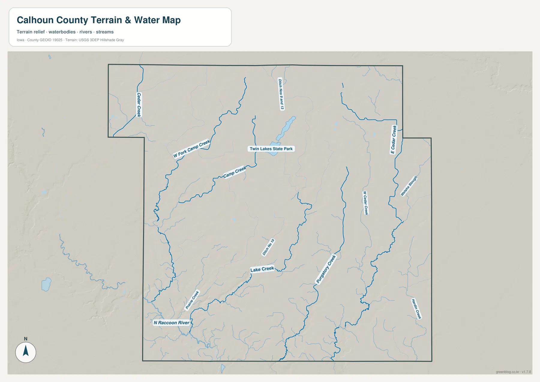
Twin Lakes is the most obvious water feature in the northern part of the county. The terrain-and-water map also labels Cedar Creek in the northwest, West Fork Camp Creek and Camp Creek farther south, and Ditch Nos. 9 and 13 near the Twin Lakes area. These features show that the lakes sit within a broader drainage landscape rather than as isolated blue shapes. The local Calhoun County recreation site also identifies Twin Lakes as one of the county’s major outdoor destinations.
The southern half has a different drainage pattern. Lake Creek crosses the central-southern area, Purgatory Creek runs farther east, and Prairie Creek approaches the North Raccoon River in the southwest. West Cedar Creek and East Cedar Creek drain parts of the eastern side, with smaller features such as Welsh Slough and Hutchins Creek also labeled. The map therefore shows several separate creek systems rather than one dominant river occupying the entire county.
The North Raccoon River is particularly useful because it can be matched directly to the elevation layer. Its southwest valley is among the lowest areas on the elevation map, and nearby tributaries descend toward it. The same relationship can be seen on a smaller scale along creeks in the southeast. Comparing the two map types makes the connection between watercourses and lower ground much clearer than either map alone.
Elevation drops from broad northern high ground toward the river valleys
The elevation legend gives an actual range of about 328 to 387 meters, with a mean of roughly 363 meters. Browns and darker tan shades cover much of the northern and west-central county, indicating the higher portions of the local terrain. The surface is not mountainous, but the shaded relief shows many shallow cuts and ridges. Around Twin Lakes and the nearby creeks, local depressions interrupt the broader high ground.
Lower greens become more common toward the southeast. West Cedar Creek, Purgatory Creek, and other drainage lines appear as narrow low corridors, and the North Raccoon River valley in the southwest is darker still. The contrast is strong enough that the county looks distinctly different from north to south even though the total elevation range is modest. Water routes that seem thin on the hydrography map become easier to understand once their valleys are visible on the terrain layer.
The colors should be read as relative elevation within Calhoun County, not as a land-use or flood-risk classification. Green areas are lower, but that does not automatically make them wetlands or designated flood zones. Brown areas are higher, but they are not mountains. Engineering, drainage design, construction, surveying, and flood-risk decisions require current professional or agency data. The map is best used to compare broad relief and the positions of valleys.
Twin Lakes and the North Raccoon River make useful opposite reference points
One practical way to remember the county is to use Twin Lakes in the north and the North Raccoon River in the southwest as two natural anchors. Rockwell City sits between those areas and provides the best central town reference. Looking south from Twin Lakes leads toward Rockwell City, then farther southwest toward Lake City and the lower river valley. This simple sequence connects natural features, communities, and road corridors without requiring the reader to memorize every small place name.
Twin Lakes is also a good example of why the map layers should be used together. The county map shows its position relative to Pomeroy, Manson, and Rockwell City; the water map adds the surrounding creeks and drainage features; and the elevation map places the lakes within the broader higher ground of northern Calhoun County. The local recreation information describes the area as a boating, fishing, biking, and camping destination, but for map reading the key point is its prominent location and relationship to the surrounding terrain.
The southwest works in the opposite way. The North Raccoon River is not as visually dominant on the basic county map, yet the water and elevation maps make its valley much more obvious. Lake City lies nearby as a town reference, and Prairie Creek enters the same lower landscape. Moving between these layers helps explain why a place that seems visually simple on the road map can show much more relief and drainage detail on the physical maps.
Choose the map by the question you need to answer
For towns, highways, and county orientation, begin with the reference map. Find U.S. 20, Iowa 4, and Iowa 175, then locate Rockwell City, Manson, Pomeroy, and Lake City. If the goal is to compare the larger communities, switch to the ranked city map. It quickly shows that the major towns are separated across the county rather than concentrated around one metropolitan center.
For physical geography, start with the water map and identify Twin Lakes, Cedar Creek, Camp Creek, Lake Creek, Purgatory Creek, and the North Raccoon River. Then move to the elevation map to see which channels occupy the lower terrain. The strongest contrast appears between the broad higher land across much of the north and the greener valleys toward the southeast and southwest. Returning to the county map afterward makes it easier to connect those natural features to nearby towns and roads.
The WebP maps in the article are sized for convenient online viewing. The downloadable JPG files are better when labels need to be enlarged, when a map will be printed, or when it will be placed in a presentation. Each supplied JPG is 3638 × 2572 pixels, so the package preserves substantially more detail than the on-page preview.
What these county maps do and do not show
These maps are county-wide reference products. They are designed to show major communities, important roads, visible water features, and broad differences in relief without overwhelming the page with every local detail. They do not include every road, parcel, building, drainage ditch, bridge condition, or survey contour. The water map is not a regulatory flood map, and the elevation map is not a substitute for a professional survey.
For legal boundaries, property work, construction, flood-risk decisions, or exact point elevations, use the current data published by the appropriate agency or a qualified professional. For general orientation, education, regional comparison, and map-based explanation, the simplified county set is useful because each layer emphasizes a different question. The best results come from moving between the road-and-town context, the hydrography, and the elevation surface rather than expecting one image to contain everything.
Frequently Asked Questions
Which map is best for locating Twin Lakes in relation to Rockwell City?
Use the county reference map first. Twin Lakes is north of Rockwell City, between the general Pomeroy and Manson area. After locating it there, the terrain-and-water map adds the nearby creek and drainage context, while the elevation map shows how the lakes sit within the higher northern portion of the county.
Why is the North Raccoon River valley lower on the elevation map?
The southwest river corridor appears in darker green because it occupies lower ground than much of the northern and west-central county. Prairie Creek and other nearby drainage lines also descend toward that lower landscape. The elevation colors show relative height, however, and should not be used by themselves to determine flood risk.
Can I download a larger Calhoun County map for printing?
Yes. The article uses smaller WebP previews for fast viewing, while the download ZIP contains 3638 × 2572 pixel JPG versions. Choose the county or city map for roads and places, and use the water or elevation map when the physical landscape is the main subject.
Map File Information
Calhoun County map files
- Included Files: Use only the versions confirmed in the article and supplied images
- File Type: Use the confirmed download contents
- Intended Use: Printing, education, presentations, and map-based projects
Related Maps
Sources and references
- U.S. Census Bureau TIGER/Line Shapefiles – county boundary and geographic reference data
- USGS National Hydrography – rivers, streams, and hydrography reference
- USGS 3D Elevation Program – elevation and terrain reference
- Calhoun County Economic Development – Recreation – local information about Twin Lakes and the North Raccoon River area
Green Map creates custom-edited map images using open geographic data sources such as geoBoundaries, Natural Earth, OpenStreetMap, and government open data.
These maps are edited visual materials, not raw data files, and are provided for education, documents, presentations, and graphic reference.