Boone County sits in central Iowa, west of Ames and northwest of Des Moines. The county makes more sense on a map when you start with two strong reference features: the city of Boone near the middle of the county and the Des Moines River valley running roughly north to south through the central area. U.S. 30 crosses the county through Boone and Ogden, while Madrid anchors the southern part of the map. This page brings those features together with city, water, and elevation views, and the same maps are available as high-resolution JPG files in the download package.
At first glance, this part of Iowa can look like a broad agricultural plain. The terrain maps show a more varied picture. The Des Moines River has cut a pronounced valley through the county, with lower ground along the river and higher surfaces on both sides. Roads and towns sit across that landscape rather than following one simple grid everywhere. Looking at the maps together helps explain why U.S. 30 is the clearest east-west reference around Boone and Ogden, while the river and its tributaries become more important for understanding the center and south of the county.
Table of Contents
Boone and U.S. 30 provide the easiest starting point
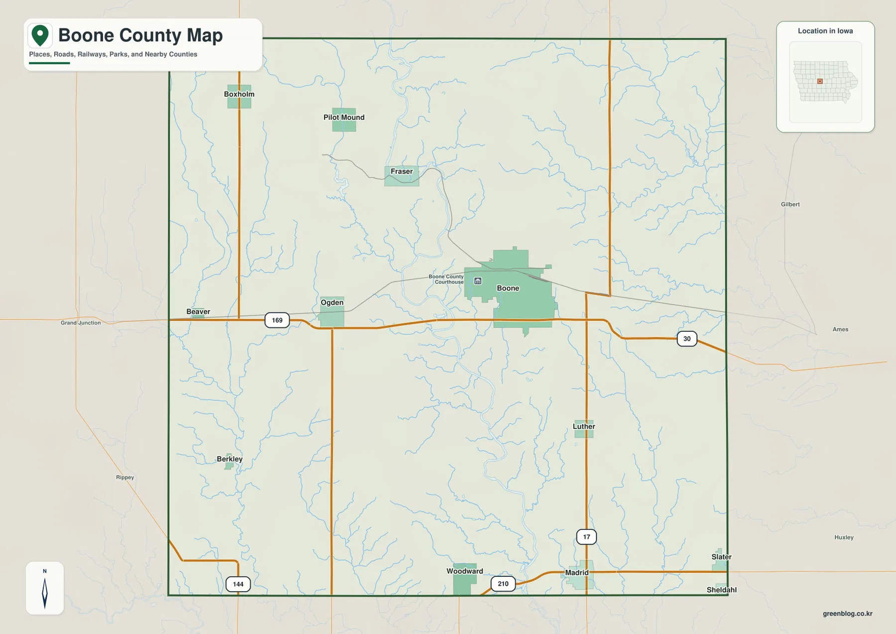
The general county map places Boone just east of the county center, with Ogden to the west along U.S. 30. That highway continues toward Story County and Ames on the east and toward the western side of the county through Ogden. Neighboring counties shown around the map include Story to the east, Greene to the west, Hamilton and Webster to the north, and Dallas and Polk to the south. These surrounding labels are useful when Boone County is being viewed as part of the larger central Iowa road network rather than as an isolated outline.
Several state and federal routes provide additional orientation. U.S. 169 runs north-south through the western side, Iowa 17 crosses the eastern interior, Iowa 144 appears near the southwest, and Iowa 210 runs through the southern area near Madrid and Woodward. Each route connects a different part of the county, so it is usually easier to locate a town by finding the nearest major road first and then using smaller roads, streams, and the county boundary to narrow the location.
The city pattern is concentrated around Boone, Madrid, and Ogden
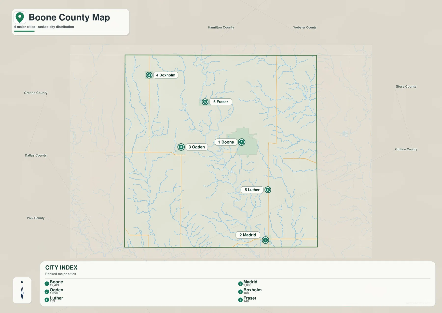
The city map highlights six places: Boone, Madrid, Ogden, Boxholm, Luther, and Fraser. Boone is clearly the largest city in the set and occupies the strongest visual position near the middle of the county. Madrid is farther south, while Ogden lies west of Boone along the U.S. 30 corridor. The smaller communities are more dispersed. Boxholm appears in the northwest, Fraser sits north of Boone, and Luther is southeast of Boone. This gives the county a noticeably uneven settlement pattern rather than a row of similarly sized towns.
The labels on the supplied city map also show a large size gap between Boone and the smaller places. That makes Boone the most practical reference when someone is approaching the county from Ames or using U.S. 30. Madrid, by contrast, is a stronger reference for the southern river valley and Iowa 210. Ogden helps orient the western half of the county, especially where U.S. 30 and U.S. 169 are the most visible routes. The city map is meant for comparing location and relative scale; it should not be treated as a parcel, address, or municipal-boundary survey.
The Des Moines River cuts a distinct valley through the county
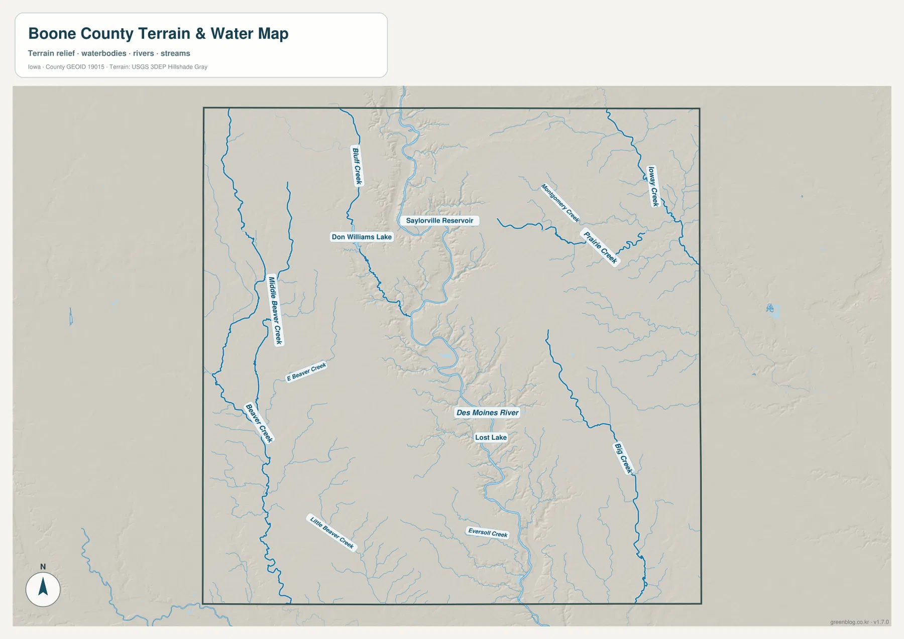
The water and terrain map is dominated by the Des Moines River. It winds from the northern part of Boone County toward the south, with a deeply incised valley visible on both sides of the channel. The map also labels Saylorville Reservoir in the north-central area, Don Williams Lake farther west, and Lost Lake near the central river corridor. These features make it easier to separate the county’s major river system from smaller lakes and tributary streams.
On the western side, the map labels Middle Beaver Creek, Beaver Creek, E Beaver Creek, and Little Beaver Creek. Prairie Creek and Big Creek are more prominent on the east, with Montgomery Creek and Avery Creek farther north and northeast. The tributaries do not create one continuous valley as broad as the Des Moines River. Instead, they form smaller branching cuts across the uplands. That contrast is useful when reading rural parts of the county where there are fewer city labels or major roads.
Boone County Conservation describes the county’s Des Moines River Water Trail as roughly 38 river miles with multiple boat ramps. That local context reinforces what the map shows: the river is not a minor drainage line but a major natural feature running through the county. The map on this page is still a general water reference. It is not a flood map, navigation chart, legal boundary map, or real-time guide to river conditions, so anyone planning a trip on the water should check current official information before going.
Elevation drops sharply into the river corridor
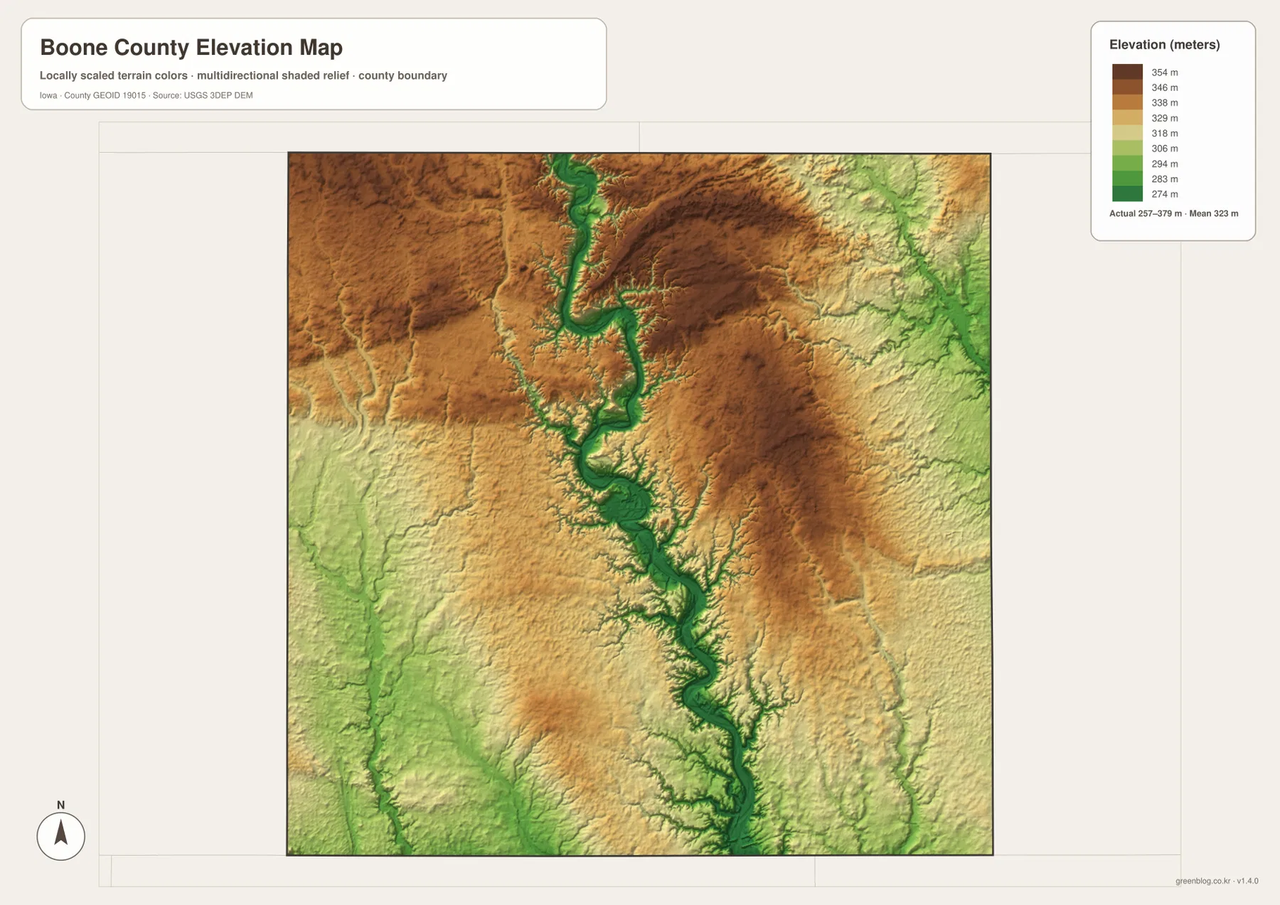
The elevation map makes the river valley even easier to see. A long green band follows the Des Moines River, while yellows and browns cover higher ground away from the channel. The legend on the supplied map gives an actual elevation range of about 257 to 379 meters and a mean of about 323 meters. That is enough relief to produce a clear valley system within a county that might otherwise be described simply as part of Iowa’s rolling interior.
The difference is especially striking in the central and southern river corridor. Iowa’s Department of Natural Resources describes nearby Ledges State Park as a landscape of steep slopes and sandstone ledges rising about 100 feet above the Des Moines River, with Peas Creek cutting through the park. That description matches the kind of abrupt relief visible on the county elevation map near the river south of Boone. It also explains why a road map alone cannot show the full character of the area around Madrid and the river valley.
This elevation surface is designed for broad comparison, not engineering measurements. It is useful for seeing where land falls toward the river, where uplands stand above the valley, and where tributaries cut into surrounding terrain. It should not be used as a substitute for a site survey, construction-grade elevation data, or a detailed contour map.
Why the map changes character between Boone and Madrid
A trip south from Boone toward Madrid crosses two different kinds of geographic reference. Around Boone, the road network and U.S. 30 dominate the map. Farther south, the Des Moines River valley and its steep sides become more important. Madrid lies near Iowa 210 and close to the river-valley landscape, so a terrain or elevation map adds information that a standard road map cannot provide. The county’s High Trestle Trail is another useful real-world example. Boone County Conservation describes a nearly 10-mile concrete trail segment that reaches a high pedestrian bridge over the Des Moines River Valley.
For map reading, that means Boone is usually easiest to understand from the highway layout first, while Madrid benefits from a road-plus-relief view. Locate Madrid and Iowa 210, then compare the river map and elevation map to see how the ground drops into the central valley. This sequence also helps explain why the southern part of the county has a different visual texture from the broad road grid west of Boone and Ogden.
Don Williams Lake and the Beaver Creek branches define the west
The western half of Boone County can be overlooked if attention stays on the Des Moines River. Don Williams Lake appears west of the main river corridor, and several Beaver Creek branches spread across the western and southwestern part of the water map. Compared with the deep, continuous Des Moines valley, these streams form narrower, more scattered drainage cuts. On the general map, this area sits south and west of Ogden and east of the U.S. 169 corridor.
Using the water and road maps together is especially helpful here because rural areas contain fewer large place labels. Ogden provides a strong northern reference, U.S. 169 marks the western side, and the creek network gives additional orientation between roads. The streams should still be treated as geographic references rather than access routes. A creek shown on the map does not imply a public crossing, public bank access, or a particular water level at the time of a visit.
Choose the map according to the question you are trying to answer
For a quick orientation, start with the general county map. It combines the county edge, city names, major highways, nearby communities, and a light water network. It is the most useful single view for finding Boone, Ogden, Madrid, or a major route before moving to a more specialized map. The city map is better when the main question is how the larger and smaller communities are distributed across the county.
Use the terrain and water map when the Des Moines River, reservoirs, lakes, or named creeks matter. It shows why the central part of the county has a different physical shape from the flatter-looking outer areas. The elevation map is the better choice for comparing valley bottoms with higher uplands. It is particularly useful when the goal is to understand relief around the river corridor rather than simply locate a road.
If the maps are being printed for a class, presentation, local reference folder, or larger display, the downloadable JPG files provide more room for labels and terrain detail than the web-sized previews. The files are separate rather than merged, so you can use the road-oriented view for one task and the water or elevation view for another without unnecessary information competing for space.
Use the county maps as geographic references, not legal surveys
These maps are designed to make the county’s broad geography easier to understand. They show major roads, selected communities, waterways, and generalized elevation, but they do not include every local road, building, parcel line, or surveyed point. Boone County GIS similarly notes that its public maps and data do not replace surveys, deeds, or other legal instruments used to define property. For property boundaries, engineering work, flood risk, or site-specific access, use the official product made for that purpose.
For regional orientation, however, a simpler county map can be more useful than a dense professional GIS screen. Find Boone or Madrid first, connect that location to U.S. 30 or Iowa 210, and then use the Des Moines River as the main north-south natural reference. Once that framework is clear, the tributaries and elevation shading add detail without making the map difficult to read.
Frequently Asked Questions
What is the most distinctive terrain feature in Boone County?
The Des Moines River valley is the strongest feature. On the elevation map, low green terrain follows the river through the center of the county while higher land rises on both sides. The contrast becomes especially noticeable south of Boone toward Madrid and the Ledges State Park area.
Which map is best for comparing Boone and Madrid?
Start with the general county map to compare their positions and the major roads around them. Add the city map if relative settlement size matters. If you also want to understand why the landscape near Madrid looks different, compare the water and elevation maps to see the nearby Des Moines River valley.
What is included in the Boone County download ZIP?
The ZIP contains four high-resolution JPG files: the county overview, city map, terrain-and-water map, and elevation map. Each JPG is 3638 × 2572 pixels, making the download more suitable than the web previews for printing or enlarged use.
Map File Information
The download package contains the Boone County overview, city map, terrain-and-water map, and elevation map as high-resolution JPG files. Use the ZIP when you need larger images for printing, classroom material, presentations, or offline reference.
- File Type: ZIP containing 4 JPG files
Related Maps
Sources and references
These official resources provide additional county, water, park, boundary, and elevation context.
- Boone County Government – county information and public services
- Boone County Conservation – Des Moines River Water Trail – local river and access information
- Iowa DNR – Ledges State Park – river-valley terrain and park information
- U.S. Census Bureau TIGER/Line Shapefiles – county boundaries and transportation features
- USGS National Hydrography – rivers, streams, and water features
- USGS 3D Elevation Program – elevation data
Green Map creates custom-edited map images using open geographic data sources such as geoBoundaries, Natural Earth, OpenStreetMap, and government open data.
These maps are edited visual materials, not raw data files, and are provided for education, documents, presentations, and graphic reference.