Allamakee County occupies Iowa’s far northeastern corner, where an inland road network meets one of the state’s most deeply cut river landscapes. Waukon sits well back from the Mississippi River and serves as the main inland reference point, while Lansing, New Albin, and Harpers Ferry line the eastern side near the river. The maps on this page show how those communities connect with the county boundary, major highways, the Upper Iowa and Yellow river systems, and a terrain surface that drops sharply toward the Mississippi. High-resolution JPG versions of the same maps are available together in the download box later on the page.
The general map immediately separates the county into two visual settings. Around Waukon and the western side, roads and settlement labels dominate the view. Farther east, the county outline bends with the Mississippi River and the background fills with branching streams, narrow valleys, and river-bottom water. Highway 9 links Waukon with Lansing, Highway 76 angles southeast toward Waterville and Harpers Ferry, and Highway 26 follows the northeastern river corridor near New Albin and Lansing. Postville appears at the southwestern edge beside the 52 and 51 route markers.
This rugged eastern landscape is not just a cartographic impression. The Iowa Department of Natural Resources describes Yellow River State Forest in Allamakee County as part of the Driftless Area, with steep slopes, rock outcrops, bluffs, and deeply dissected terrain. Effigy Mounds National Monument, whose visitor center is near Harpers Ferry, occupies another section of the Upper Mississippi River Valley. Those county-specific features make water and relief unusually important here, so the article follows the landscape from Waukon toward the Mississippi rather than treating the maps as four interchangeable illustrations.
Table of Contents
Waukon anchors the road network while the county opens to the Mississippi
Waukon is the clearest starting point on the general county map. Iowa Highway 9 crosses the county from the west, passes through Waukon, and continues east toward Lansing. South of Waukon, Highway 76 turns southeast through the hillier interior before reaching the Harpers Ferry side of the county. The contrast between those routes is useful: Highway 9 reads as the main west-to-east connection, while 76 follows a more diagonal path through terrain cut by many tributaries.
The eastern boundary is much less regular than the straight western and southern edges. Near New Albin, Lansing, and Harpers Ferry, the county line follows the Mississippi River corridor, bending around broad water areas and floodplain channels. New Albin occupies the narrow northeastern corner close to the state line, Lansing sits farther south where Highway 9 reaches the river, and Harpers Ferry lies on the southeastern side below a dense set of tributary valleys. Their locations make the river edge a defining part of the county rather than simply a border drawn at the edge of the map.
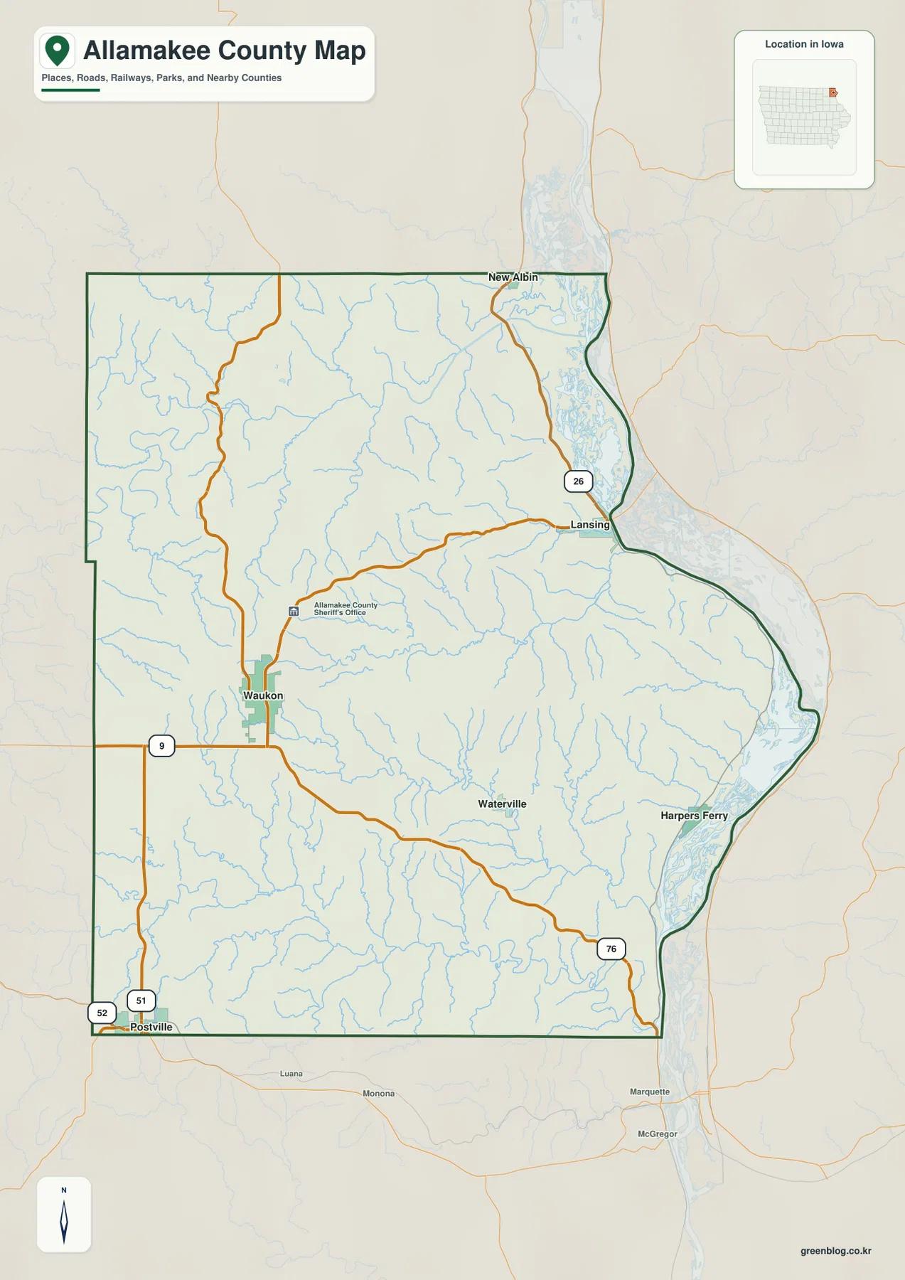
Postville is shown at the southwestern edge, close to the 52 and 51 route markers, while Waterville appears southeast of Waukon along the route toward the river country. Between these communities, the road network crosses a large rural interior. Yet the numerous blue tributary lines keep the map from looking like a simple rectangular farm-grid county. As the roads approach the eastern half, they bend more often around valleys and ridges, especially near the Mississippi-facing communities.
The general map is therefore the best orientation layer. It combines communities, numbered roads, county edges, and many streams in one view. It is not a live navigation product, so current closures or road conditions should be checked separately, but it gives enough context to understand why Waukon functions as an inland hub and why travel toward the river follows a smaller number of valley routes.
Six communities form an inland-to-river settlement pattern
The city distribution map reduces the road detail and highlights six communities: Waukon, Postville, Lansing, New Albin, Harpers Ferry, and Waterville. Their arrangement is more informative than a simple list. Waukon is inland near the west-central part of the county, Postville is at the southwest edge, and three communities—Lansing, New Albin, and Harpers Ferry—sit close to the Mississippi side. Waterville occupies a smaller interior position between Waukon and the Harpers Ferry area.
The CITY INDEX printed below the map ranks the mapped communities by the size value used in the graphic. Waukon appears first, followed by Postville and Lansing, while New Albin, Harpers Ferry, and Waterville are shown as smaller places. Those figures are best treated as the map’s city reference rather than a replacement for the latest Census estimate. Their main value here is to show that the county’s population centers are not evenly spaced or equal in scale.
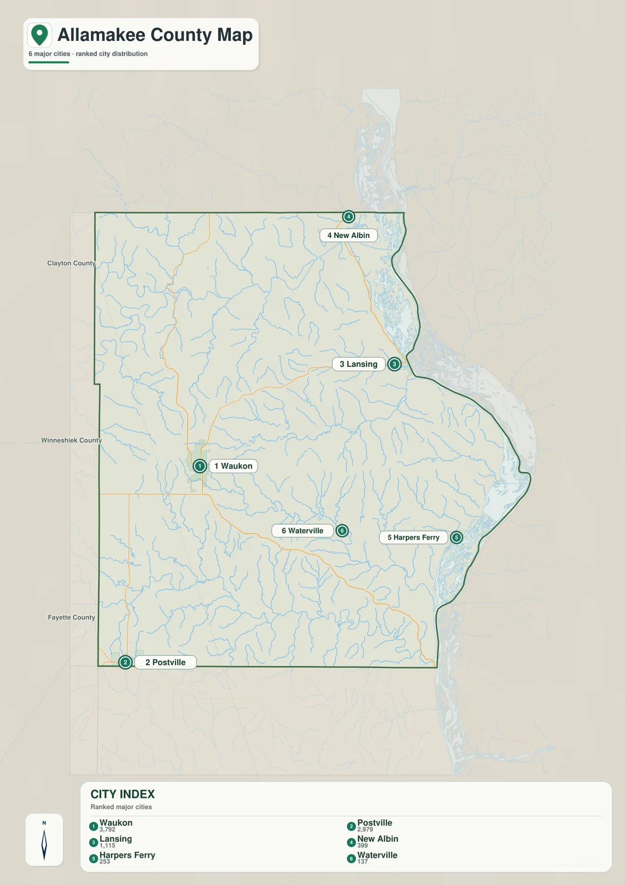
From Waukon, Lansing lies nearly due east, New Albin is farther northeast, and Harpers Ferry is southeast. Waterville sits inland from Harpers Ferry, which helps explain why Highway 76 serves as a useful connection between the interior and the Mississippi side. Iowa DNR directions for Yellow River State Forest place major forest facilities southeast of Waterville and west of Harpers Ferry, matching the transition zone visible between the inland city pattern and the more rugged river-facing terrain.
The map also shows neighboring Clayton, Winneshiek, and Fayette counties along the western and southern sides, helping place Allamakee within northeast Iowa. Because the Mississippi forms the eastern edge, the county does not simply continue into another Iowa county in that direction. The settlement pattern instead turns toward river crossings, valley roads, and communities built close to the water, which is why the eastern places look so different when the city map is compared with the elevation layer.
Upper Iowa, Paint Creek, and Yellow River carve a dense drainage network
The terrain-and-water map makes Allamakee County’s drainage network much more prominent. In the north, the Upper Iowa River enters from the west and swings across the county in broad bends before reaching the Mississippi side. Bear Creek, Waterloo Creek, Clear Creek, and other tributaries join the river through narrow valleys. The shaded relief around those channels shows that the river is not crossing a flat plain; it is cutting through a landscape of closely spaced ridges and side valleys.
Farther south, Village Creek and Paint Creek form long eastward-trending valleys. The Yellow River occupies the southern part of the county, winding east through another deeply cut corridor toward the Mississippi. Williams Creek and many unnamed tributaries feed into the larger channels. This branching pattern gives the southern half a textured appearance, with watercourses repeatedly separating narrow uplands rather than collecting into one broad central valley.
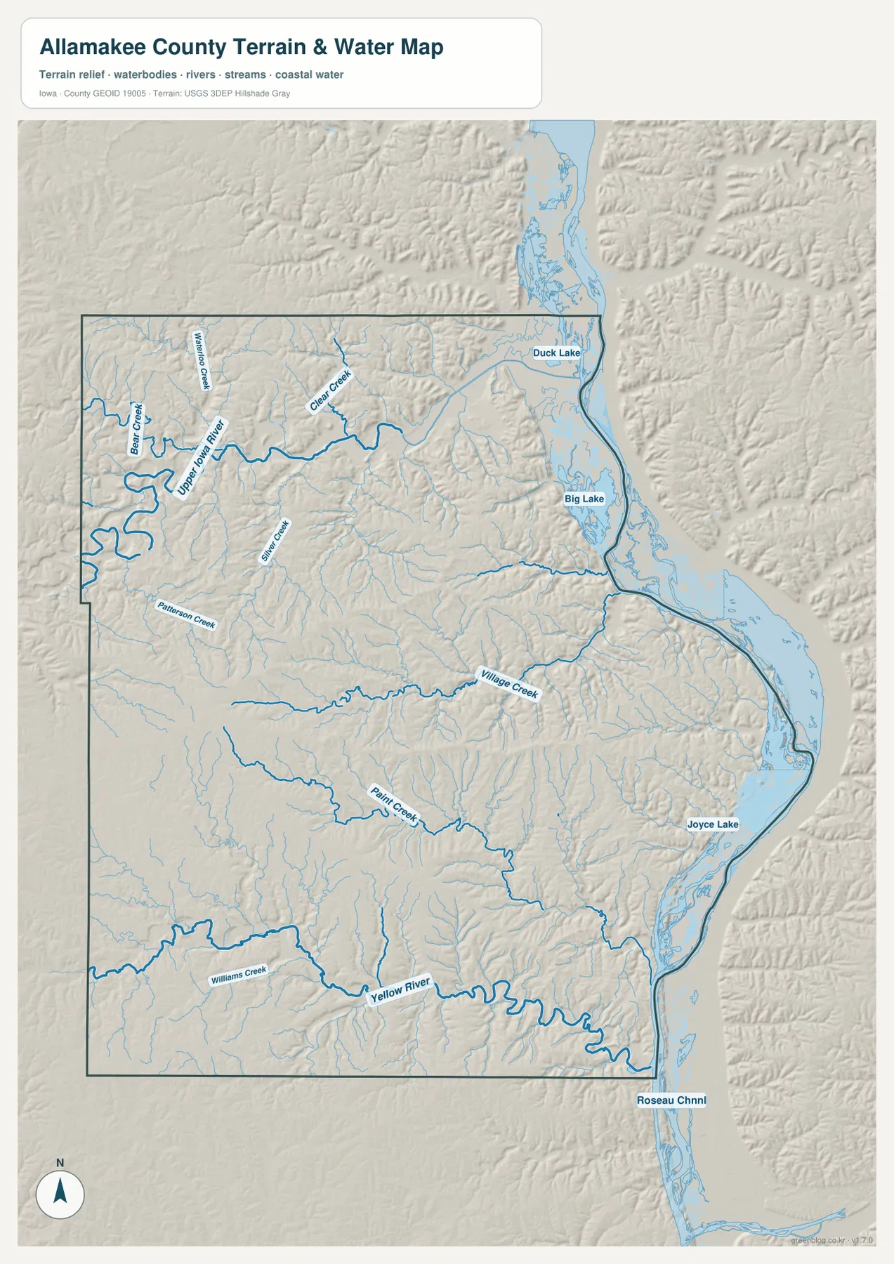
Along the eastern margin, the water pattern changes scale. Duck Lake, Big Lake, Joyce Lake, and other backwater features appear beside the broad Mississippi corridor, creating a much wider zone of water than the inland creeks. This is especially noticeable east of Lansing and Harpers Ferry, where small tributary valleys descend from the bluffs and meet the river-bottom system. Comparing those areas with the narrow Upper Iowa or Yellow River channels helps distinguish the Mississippi floodplain from the county’s interior drainage.
Effigy Mounds National Monument provides a useful real-world reference for this river-facing terrain. The National Park Service places the monument near Harpers Ferry in the Upper Mississippi River Valley, where high viewpoints overlook the river. The map on this page is not a park map, but the combination of steep tributary valleys and the broad Mississippi water corridor explains why this portion of Allamakee County has such a strong bluff-and-river character.
This water layer should be read as a geographic reference, not as a flood-risk, parcel, or navigation chart. A mapped stream shows the location of a watercourse, not the legal edge of a floodplain or private property. River access, current water levels, boating conditions, and flood information can change and should be checked with the appropriate agency when those details matter.
Relief climbs from the river edge into 400-meter uplands
The elevation map shows an actual county range of about 189 to 408 meters, with a mean near 304 meters. Greens represent the lower terrain and tan-to-brown colors mark higher ground. The strongest low zone runs along the Mississippi River on the eastern boundary, while broad higher surfaces occupy much of the west and southwest. Between those larger areas, narrow green valleys penetrate far inland along the county’s major rivers and creeks.
The Upper Iowa River valley is especially easy to follow in the north because its broad bends appear as a continuous low corridor surrounded by higher ridges. In the south, the Yellow River creates another long green passage, with many short tributary valleys branching from it. Central Allamakee is divided by smaller streams that produce repeated ridge-and-hollow relief. The overall impression is not one of a flat county slowly rising westward, but of a dissected upland repeatedly cut by water.
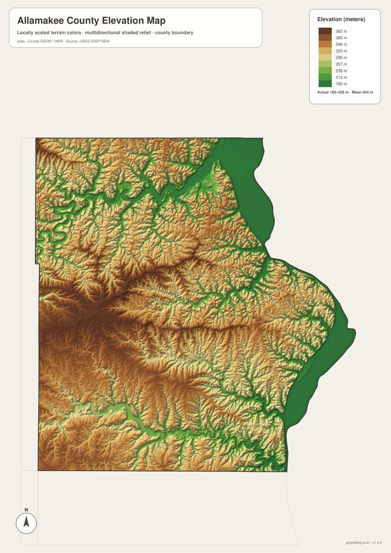
The Mississippi edge is the most dramatic contrast. Low green terrain follows the river, but immediately to the west the map rises into narrow ridges and bluff country. Lansing and Harpers Ferry sit where settlement and roads must fit into that narrow river-facing zone. Waukon, by comparison, occupies higher inland terrain, though even its surroundings are crossed by enough tributaries that the surface never becomes completely uniform.
Iowa DNR describes most of Allamakee County as part of the Paleozoic Plateau, a region with exposed limestone and sandstone bedrock and much deeper dissection than most of Iowa. That description matches the strong shaded relief visible here. The elevation layer is still a generalized county-scale surface, however. It is useful for comparing valleys and uplands but should not be treated as survey-grade data for construction, property work, or precise slope measurement.
Roads, rivers, and relief explain the county better when compared
The four map layers become more useful when a feature is followed from one to another. On the general map, the Upper Iowa River is one of many blue lines across the north. On the water map, it becomes a major winding channel with numerous tributaries. On the elevation map, the same route appears as a low green valley surrounded by higher ridges. Moving between the layers connects road position, water flow, and landform without asking one map to show every detail at once.
The Yellow River works the same way in the south. Its water map line follows a long valley toward the Mississippi, while the elevation map shows the lower corridor cut between higher uplands. Near the Harpers Ferry side, that valley approaches the much broader Mississippi lowland. The Iowa DNR description of rugged terrain in Yellow River State Forest makes more sense when these two map views are compared directly.
The city pattern also becomes easier to interpret. Lansing, New Albin, and Harpers Ferry occupy the low eastern edge close to the Mississippi, while Waukon stands farther west on higher inland ground. Waterville sits between those two settings, and Postville marks the southwestern edge. The city map intentionally leaves out most relief, but the elevation layer explains why the eastern communities are constrained by valleys, bluffs, and river-bottom land in a way that Waukon is not.
That contrast is what makes Allamakee County distinctive. A map limited to roads could make the western half look similar to many rural Iowa counties, while a map limited to relief could make it difficult to find the communities. Used together, the maps show an inland road center at Waukon, a chain of Mississippi-side settlements, and a network of river valleys that cuts through the entire county.
Choose the map by the question you need to answer
Start with the general county map when you need boundaries, communities, highways, and streams on one page. It is the best choice for locating Waukon, following Highway 9 toward Lansing, checking Highway 76 toward Harpers Ferry, or seeing how Postville relates to the southwestern county edge. It also provides the clearest overall relationship between the inland road network and the Mississippi boundary.
Use the city distribution map when community location is the main topic. With most secondary road detail removed, the six mapped places stand out immediately. It is particularly useful when explaining that Waukon and Postville are inland while Lansing, New Albin, and Harpers Ferry occupy the river side, and that Waterville sits between the two settings.
The terrain-and-water map is the strongest choice for the Upper Iowa River, Paint Creek, Yellow River, Mississippi backwaters, and the branching tributary system. The elevation map answers a different question by showing where those channels sit within low valleys and where the surrounding uplands rise. Pairing the two is often more informative than using either alone because the water map names the channels while the elevation surface reveals the shape of the land around them.
The downloadable ZIP contains the original high-resolution JPG versions corresponding to the general county map, city distribution map, terrain-and-water map, and elevation map shown above. Each image is 2572 by 3638 pixels, providing more detail than the WebP previews displayed in the article. Review the previews first, then use the full files when you need a larger image for printing, offline reference, teaching material, or closer inspection.
Three cautions matter in this bluff-and-river landscape
First, the road and city maps are orientation tools rather than live navigation products. Construction, seasonal restrictions, and temporary closures can change after a map is created. This matters especially in steep river-valley areas where only a limited number of roads may connect one ridge or valley with another. Use current routing information when planning an actual trip.
Second, the water map does not define flood zones, property lines, or navigable water. The broad Mississippi backwater area and the smaller inland streams are mapped for geographic context. Water level, access, flood extent, and boating conditions can vary with season and weather, so official current sources should be used for safety or legal decisions.
Third, the 189–408 meter elevation range describes county-scale terrain. It is very useful for distinguishing the Mississippi lowland from the higher western interior and for tracing the low Upper Iowa and Yellow River valleys, but it cannot replace a site survey or engineering elevation. The strongest use of the map is comparative: identify where the land is lower or higher, then connect that pattern with the named rivers and roads on the other layers.
Allamakee County rewards that kind of comparison because its geography changes quickly over a short distance. Waukon’s inland road setting, the deeply cut Driftless tributaries, the Mississippi bluff edge, and the river-side communities all belong to the same county but look very different depending on the layer. Choosing the map that matches the question produces a clearer picture than trying to read every road, stream, city, and contour from a single image.
Frequently Asked Questions
Which map is best for locating Lansing, New Albin, and Harpers Ferry along the Mississippi side?
The city distribution map is the quickest way to compare the three river-side communities with Waukon and Postville. Use the general county map when you also need Highway 9, 76, or 26, and add the water and elevation maps when you want to understand the Mississippi lowland, tributary valleys, and surrounding bluffs.
How can I tell the Upper Iowa River from the Yellow River on these maps?
The Upper Iowa River crosses the northern part of Allamakee County in broad bends before reaching the Mississippi side. The Yellow River runs across the southern part of the county toward the Harpers Ferry area. Their names and tributaries are clearest on the terrain-and-water map, while the elevation map shows both as low green valleys cut into higher surrounding terrain.
What files are included in the downloadable ZIP?
The ZIP contains one high-resolution JPG for each map shown in the article: the general county map, city distribution map, terrain-and-water map, and elevation map. Each file is 2572 by 3638 pixels and corresponds to the WebP preview used in the page body.
Map File Information
Download the Allamakee County maps shown in this article as high-resolution JPG files.
- Printable Size: 2572×3638 pixels each
Related Maps
Sources and references
- Allamakee County Government — county government and Waukon administrative information
- Iowa DNR – Yellow River State Forest — Driftless terrain and Yellow River landscape in Allamakee County
- National Park Service – Effigy Mounds National Monument — Harpers Ferry and Upper Mississippi River Valley context
- U.S. Census Bureau QuickFacts – Allamakee County — current county population and statistical reference
- USGS National Hydrography — river and waterbody reference
- USGS 3D Elevation Program — elevation reference
Green Map creates custom-edited map images using open geographic data sources such as geoBoundaries, Natural Earth, OpenStreetMap, and government open data.
These maps are edited visual materials, not raw data files, and are provided for education, documents, presentations, and graphic reference.