Adair County lies in southwest Iowa, with Greenfield near the middle of a broad rural county and smaller communities spread toward the north, west, southwest, and south. The general map makes the pattern easy to see: Interstate 80 and U.S. 6 pass near the northern edge around Stuart and Adair, Iowa 25 runs north-south near Greenfield, and Iowa 92 provides an important east-west route through the central part of the county. Beneath the road network is a dense web of creeks and rivers, while the elevation map shows higher ground across much of the west and lower valleys toward the east.
The maps on this page are meant to be read together without forcing every detail into one graphic. The county map is best for boundaries, roads, and place names. The city index strips away most of that detail so Greenfield, Stuart, Adair, Fontanelle, Orient, and Bridgewater are easier to compare. The terrain-and-water map brings the North, Middle, Thompson, and Nodaway river systems forward, while the elevation map explains why so many streams occupy narrow lower corridors between ridges. High-resolution JPG versions of all four supplied maps can be downloaded in one ZIP archive from the map file box below.
Table of Contents
Greenfield links the Iowa 25 and Iowa 92 corridors south of I-80
Greenfield is the most useful starting point on the general county map because several of the county’s visible routes can be understood from its position. Iowa 25 runs roughly north and south through the central part of the county, while Iowa 92 crosses the Greenfield area from west to east. Farther north, Interstate 80 and U.S. 6 run near Stuart and the northern boundary. Adair is farther west along the same upper part of the county, and Fontanelle sits southwest of Greenfield. Orient lies near the south-central edge, while Bridgewater occupies the southwest corner area.
The local road pattern is much denser than the handful of numbered highways. Around Greenfield and Fontanelle, many roads form a loose grid, then extend north toward the I-80 and U.S. 6 corridor or south toward Orient and the county line. On the east side, Iowa 92 provides a clear reference route, while the Adair County Courthouse label appears near Greenfield. The map therefore works well for understanding how the county’s principal communities fit into a mostly rural road network without treating every small road as equally important.
Adair County’s official website says the county was established in 1851 and identifies Greenfield as the location of county government. The county sheriff’s history page adds that Greenfield became the legal county seat in 1875 after an extended dispute with Fontanelle. That history gives extra context to the present-day map: Greenfield is not only centrally located on the road network but also the administrative focus of the county, while communities such as Stuart and Adair sit closer to the interstate corridor at the northern edge.
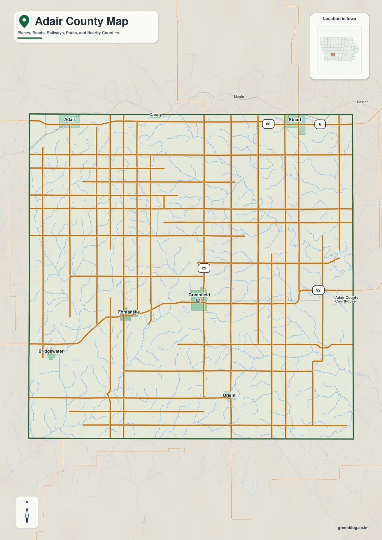
This general map is a regional reference rather than a legal parcel or real-time transportation product. It is useful for seeing where Greenfield sits in relation to the county outline, how the northern I-80 corridor differs from the central Iowa 92 corridor, and where the other communities fall around them. For a property boundary, construction project, road closure, or other situation that depends on current official detail, the appropriate government source should be consulted. For ordinary county orientation, however, this map provides the clearest single overview.
The six-city index spreads from Adair and Stuart to Bridgewater and Orient
The city map ranks six major communities and makes their separation much easier to read than on the full county map. Greenfield is marked first near the center, Stuart second near the north-central edge, and Adair third toward the northwest. Fontanelle is west-southwest of Greenfield, Orient is close to the southern edge, and Bridgewater lies farthest southwest. The six points do not form a single corridor. Instead, they show how settlement is divided between the interstate-facing north, the central Greenfield area, and the smaller communities farther south and west.
The population figures printed in the map’s city index are 1,894 for Greenfield, 1,655 for Stuart, 830 for Adair, 615 for Fontanelle, 448 for Orient, and 124 for Bridgewater. Those numbers are best treated as the values used for this particular ranked map rather than as a substitute for a current Census lookup. Even so, they explain the visual order: Greenfield and Stuart stand out as the two largest labeled communities, while Bridgewater is much smaller. The map is therefore useful when a reader needs a quick sense of relative community size as well as location.
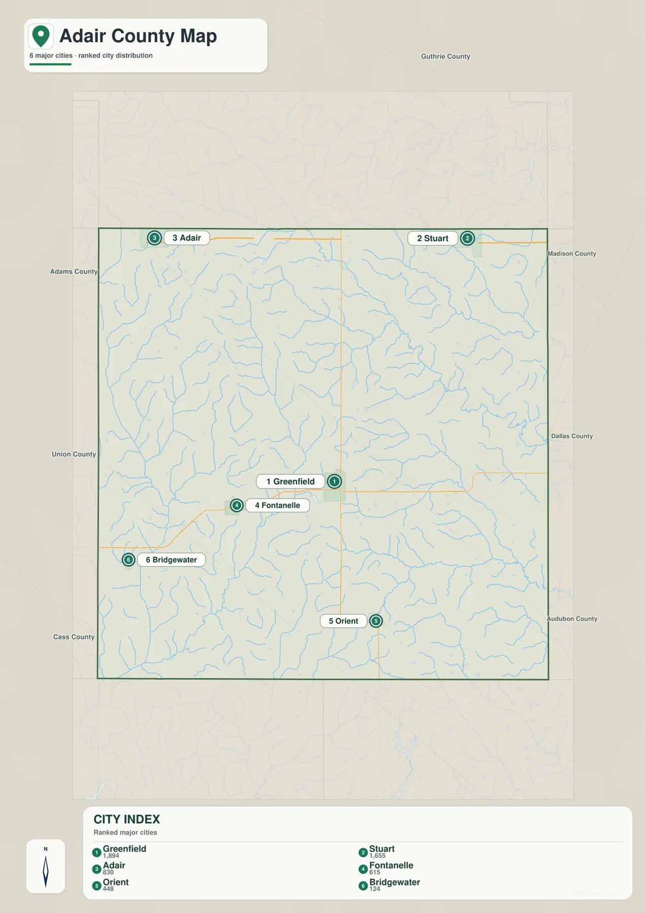
Position matters as much as rank. Stuart and Adair sit close to the northern boundary, which places them near I-80 and U.S. 6. Greenfield occupies the center of the county’s road system, Fontanelle fills a western interior position, Orient anchors the south-central area, and Bridgewater is tucked into the southwest. The official Adair County communities page lists these same six communities, so the map’s selection corresponds well with the county’s own community directory.
Use the city map when the main question is simply “where are the principal communities?” It is intentionally less detailed than the county map and does not try to show every road or stream. If a route between Greenfield and Stuart or Greenfield and Fontanelle matters, return to the general map after using this city index for orientation. That two-step approach is clearer than asking one crowded image to handle community ranking, roads, boundaries, and hydrography at the same time.
North, Middle, Thompson, and Nodaway rivers divide the county into separate valleys
The terrain-and-water map changes the emphasis completely. In the northeast, the North River and Middle River appear as strong blue channels, with smaller tributaries feeding them. The Thompson River occupies the east and southeast, while the Middle Nodaway River runs through the western and southwestern part of the county. Near the southern edge, the East Nodaway River is also labeled. Rather than one dominant river crossing the entire county, Adair County contains several drainage corridors separated by rolling higher ground.
Named smaller features add detail to that pattern. North Turkey Creek joins the northern network, while Marvel Creek, Ninemile Creek, and Threemile Creek appear across the southeast. Rich Branch and a West Fork of the Middle Nodaway are labeled in the west. Nodaway Lake sits along the Middle Nodaway system, and Meadow Lake appears farther north in the central part of the county. Numerous unnamed tributaries fill the spaces between these features, showing that the rural road grid overlies a surprisingly intricate stream network.
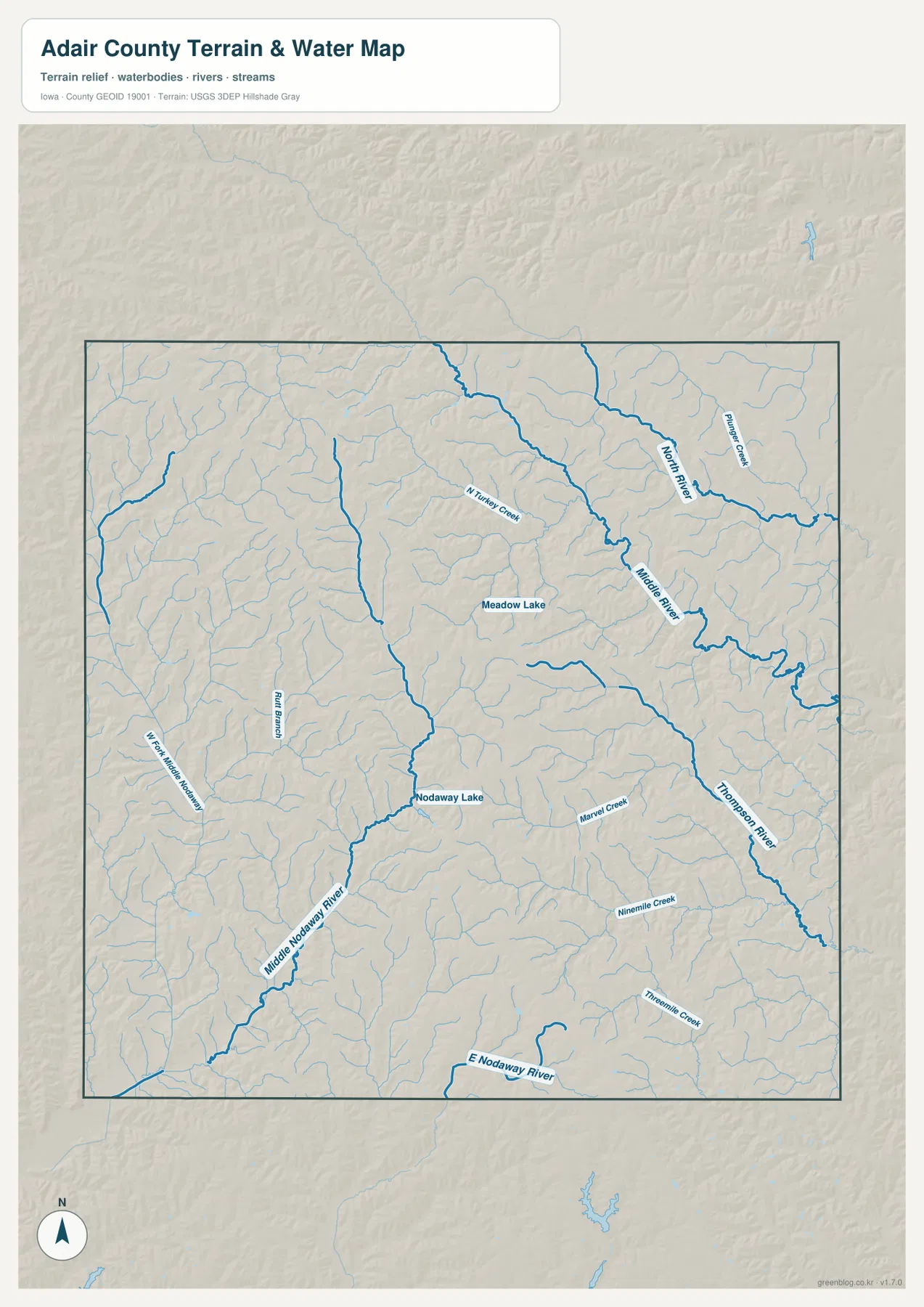
A practical way to read the map is to divide it into three broad areas. The northeast is organized around the North and Middle rivers. The east and southeast are strongly influenced by the Thompson River and its tributaries. The west and southwest are tied to the Middle Nodaway system, with the East Nodaway near the south. This approach makes the map easier to understand than trying to follow every blue line at once, and it helps explain why roads sometimes bend around or cross a repeated sequence of stream valleys.
This is a geographic water-reference map, not a flood hazard map, navigation chart, water-quality report, or legal description of stream boundaries. It should not be used to decide whether a property floods or whether a waterway is safe to cross. Its value is showing named rivers, lakes, and tributaries in relation to the county outline and relief. For a reader who wants to understand where the Nodaway waterways sit compared with the Middle River or Thompson River systems, this version is far more direct than the road-focused county map.
Elevation falls from western ridges toward lower eastern river corridors
The elevation map gives Adair County a strong west-to-east visual contrast. Its legend reports an actual range of about 321 to 449 meters and a mean near 388 meters. Brown and tan colors indicate relatively higher ground, while green shades mark lower terrain within the county. The western and northwestern parts contain broad areas of higher color, and elevated ridges continue through portions of the center and south. By contrast, greener zones become more common along the eastern side and in the valleys cut by the main rivers.
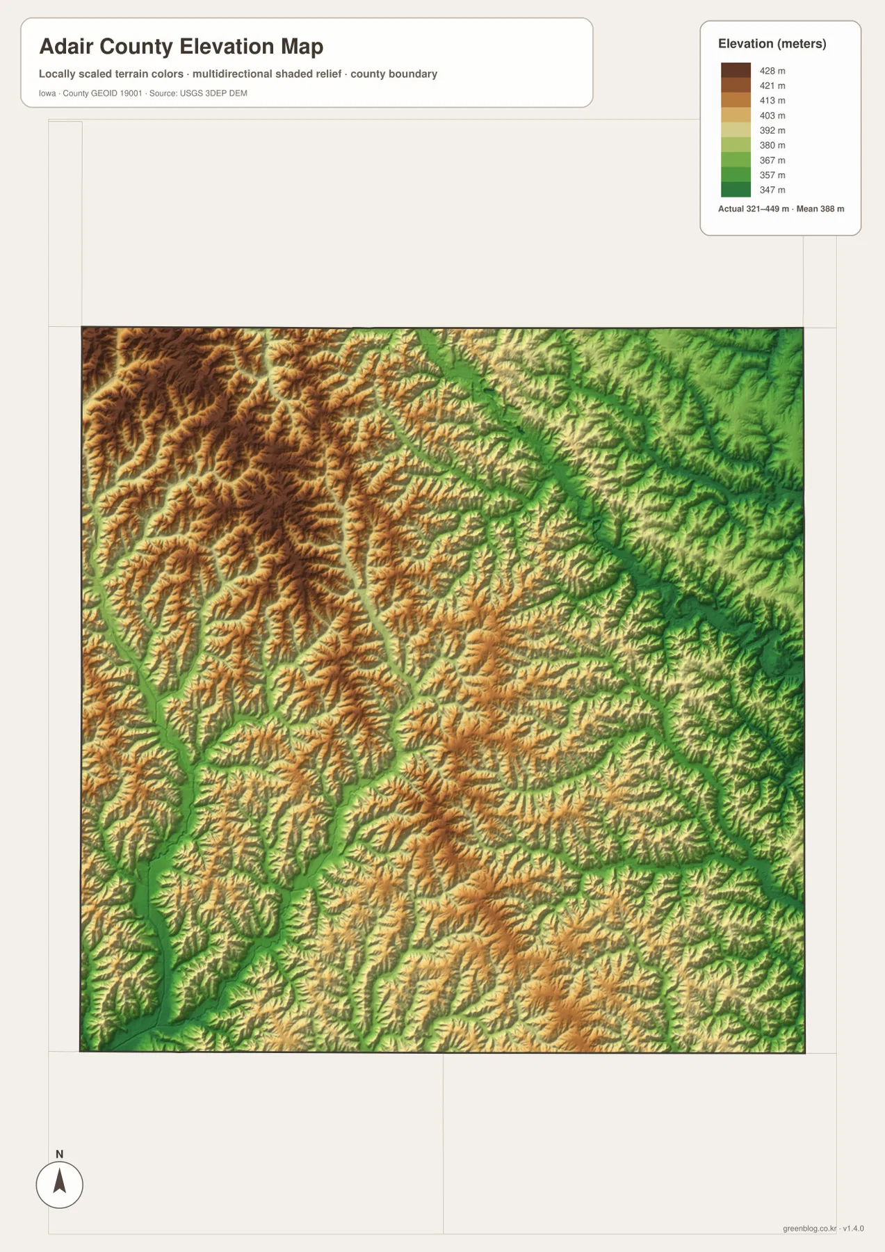
The surface is not a simple ramp from high west to low east. Narrow green valleys cut back into the higher terrain, and tan ridges reappear between them. The North and Middle River corridors in the northeast follow lower ground, as does the Thompson River farther southeast. The Middle Nodaway River also occupies a lower corridor in the west and southwest, even though the surrounding western part of the county is generally higher. This repeated ridge-and-valley texture is one of the most distinctive features of the supplied map set.
Greenfield sits in a middle-elevation part of the county rather than at either extreme. Moving west toward Fontanelle, the map shows more frequent high ridges, while the eastern edge contains broader lower colors and deeply incised drainage lines. The northwest is especially elevated compared with the main eastern river valleys. That makes it more accurate to describe Adair County as rolling terrain dissected by streams than as a completely flat agricultural surface.
The elevation image is designed for countywide comparison, not survey or engineering measurement. The 321–449 meter range is useful for understanding the scale of relief across Adair County, but it does not provide a precise elevation for an individual field, road crossing, building site, or drainage structure. Projects that need exact height values should use current USGS elevation data or professional survey information. For general geographic reading, the map clearly explains why the water network follows so many narrow lower corridors between higher ridges.
Choosing the map that matches the question
Choose the general county map when you need the county outline, major roads, surrounding locations, and several communities together. It is the strongest first map for explaining where Greenfield lies and how Iowa 25, Iowa 92, I-80, and U.S. 6 relate to the county. Choose the city index when the road detail is unnecessary and the goal is to compare Greenfield, Stuart, Adair, Fontanelle, Orient, and Bridgewater. The cleaner layout makes the settlement pattern easier to discuss without unrelated labels.
Use the terrain-and-water map when the North, Middle, Thompson, or Nodaway river systems are the main subject. It is also the best choice for locating Nodaway Lake, Meadow Lake, and the smaller named creeks. Use the elevation map when relief matters: higher western ground, lower eastern valleys, and the way stream corridors cut through the ridges. Looking at the water and elevation maps side by side is especially useful because each explains part of the same landscape without duplicating the other.
The WebP images in the article are sized for convenient online viewing. The download archive contains the corresponding high-resolution JPG originals at 2572×3638 pixels each, stored as four separate files. You can extract only the map needed for a lesson, printed handout, presentation, or personal reference. For legal boundaries, flood decisions, engineering design, navigation, or real-time road conditions, rely on the relevant official data rather than these simplified reference graphics.
Frequently Asked Questions
Which map is best for comparing Greenfield with Adair and Stuart?
The city index is the quickest option because it highlights all six major communities without the full road network. Greenfield is near the center, while Adair and Stuart sit close to the northern boundary. If you also need to see how those places connect to I-80, U.S. 6, Iowa 25, or Iowa 92, use the general county map as a second view.
Do the Nodaway rivers and the Middle River occupy the same part of Adair County?
No. The terrain-and-water map separates them clearly. The Middle River and North River are most prominent in the northeast, the Thompson River follows the east and southeast, and the Middle Nodaway River runs through the west and southwest. The East Nodaway River appears near the southern edge. Reading the county as several river valleys makes the drainage pattern easier to understand than treating it as one continuous river system.
Can the 321–449 meter elevation range be used for surveying a property?
No. The elevation map is a generalized countywide surface meant to show relative relief. The range and mean in the legend help describe higher western ridges and lower eastern or river-valley terrain, but they are not precise point elevations for a parcel or structure. Surveying, drainage design, construction, and similar work require authoritative elevation data or a professional site survey.
Map File Information
Download the Adair County maps as high-resolution JPG files in one ZIP archive. The county, city, terrain-and-water, and elevation maps are included as separate original images.
- Printable Size: 2572×3638 pixels each
- File Type: ZIP containing 4 JPG files
Related Maps
Sources and references
These official sources provide background on Adair County and the boundary, hydrography, and elevation information represented in the maps.
- Adair County, Iowa official website – county background and government location
- Adair County official Communities page – local community directory
- Adair County Sheriff history page – history of the county seat at Greenfield
- U.S. Census Bureau TIGER/Line Shapefiles – county boundaries and geographic framework
- USGS National Hydrography – rivers, streams, lakes, and other water features
- USGS 3D Elevation Program – elevation and terrain data
Green Map creates custom-edited map images using open geographic data sources such as geoBoundaries, Natural Earth, OpenStreetMap, and government open data.
These maps are edited visual materials, not raw data files, and are provided for education, documents, presentations, and graphic reference.