Washington County is centered on Salem, with roads spreading toward Campbellsburg and Saltillo in the west, New Pekin in the southeast, Livonia in the southwest, and Little York near the northeastern side. The physical landscape is more varied than the road grid suggests: Muscatatuck River and several creeks occupy the north, while Blue River and its forks cut deep valleys across the southern half. This Washington County Indiana Map page connects those towns, roads, rivers, lakes, and a relief surface ranging from about 152 to 319 meters. Below, you can download Washington County’s four 2572×3638 high-resolution JPG originals in one ZIP for close inspection or A3 printing.
Salem is the easiest fixed point for moving between the maps. Route 60 approaches from the Campbellsburg side, Route 160 heads east, and Route 135 continues south toward the New Pekin–Martinsburg area. Livonia sits farther southwest near Routes 56 and 337, while Little York is a useful northeastern reference near Routes 39 and 256. Once Salem is located, the long county shape becomes much easier to organize.
The elevation view shows an actual county range of about 152 to 319 meters and a mean of 231 meters. Lower green corridors follow Blue River and many of its tributaries, while broad tan and brown hills cover much of the east and southeast. The northern edge is also broken by Muscatatuck River and narrow creek valleys, so the terrain changes repeatedly rather than forming one smooth upland surface.
Table of Contents
Salem connects the western towns with New Pekin and the eastern road network
Salem is the clearest starting point on the general county map. Route 60 links the city with Campbellsburg to the west, Route 160 continues east, and Route 135 provides the strongest southbound reference. That road pattern makes Salem a practical anchor for locating the communities around every side of the county.
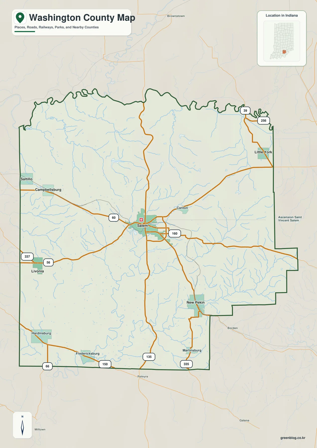
Campbellsburg and Saltillo occupy the western side along the Route 60 direction, while Livonia lies farther southwest near Routes 56 and 337. Hardinsburg and Fredericksburg provide additional references close to the southern and southwestern boundary. The western road pattern is relatively simple, but the terrain-and-water map shows many small channels crossing the same area.
Little York sits near the northeastern side around Routes 39 and 256. Canton lies between Salem and the eastern interior and works well as a middle reference when scanning that side of the county. New Pekin is much farther south and east, so the Salem–Little York and Salem–New Pekin directions help define the county’s broad eastern reach.
Near the southern edge, Route 150 and Route 66 are visible around the Fredericksburg side, while Route 335 appears near Martinsburg. The general view is useful for place names, route direction, and county boundaries; temporary construction and current travel restrictions should be checked with a live transportation source.
Six highlighted communities spread outward from Salem
The city view highlights Salem, New Pekin, Campbellsburg, Little York, Saltillo, and Livonia. Salem sits near the center of the highlighted distribution, New Pekin lies southeast, Campbellsburg and Saltillo are west, Little York is northeast, and Livonia is southwest. The simplified view makes it clear that Washington County’s communities are spread in several directions rather than forming one compact corridor.
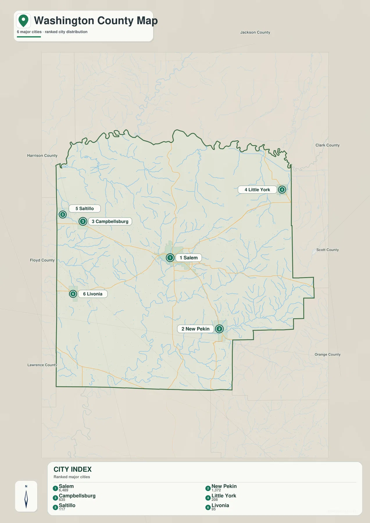
The CITY INDEX prints numeric values beside the six names, but the supplied graphic does not identify a statistical year or provide a separate source for those values. This page therefore does not present them as current official population. A recent U.S. Census release should be used when up-to-date population counts are needed.
Jackson, Clark, Scott, Orange, Lawrence, Floyd, and Harrison counties are labeled around the outside of the city view. Those neighboring names help place Little York near the Clark County side, New Pekin toward the Scott County direction, and Livonia closer to the Floyd–Harrison side of southern Indiana.
The settlement pattern also helps organize the water map. North of Salem, Muscatatuck River and creeks such as Twin, Buffalo, and Delaney occupy the hill country. South of the county seat, the Blue River system becomes the dominant drainage feature, with several named forks and small lakes spread through the valleys.
Blue River and its forks divide the southern half into several valleys
Blue River is the strongest named water feature in the southern half of the terrain-and-water map. West Fork Blue River descends through the central area, while Blue River Middle Fork and South Fork Blue River occupy separate eastern and southeastern valleys. The main Blue River channel continues toward the southern boundary, linking the low corridors together.
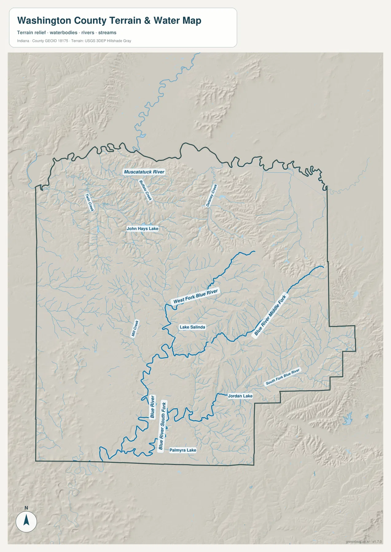
The northern map has a different water pattern. Muscatatuck River follows the upper part of the county, while Twin Creek, Buffalo Creek, and Delaney Creek descend through the surrounding hills. John Hays Lake is labeled as a separate inland water body and is easy to distinguish from the longer branching creeks.
South of Salem, Mill Creek approaches the Blue River system and Lake Salinda appears in the central-southern interior. Jordan Lake sits farther southeast, and Palmyra Lake is labeled near the southern edge. These lakes are shown as separate water bodies rather than one connected lake system.
Use this hydrology view to locate Washington County rivers, creeks, and lakes at county scale. It does not define flood boundaries, parcel lines, legal water limits, depth, or navigation conditions; those questions require current agency records created for those purposes.
The 152–319 meter surface rises from creek valleys into eastern and southeastern hills
The elevation legend gives Washington County an actual range of about 152 to 319 meters and a mean of 231 meters. Blue River and its tributaries appear as green and light-green low corridors, while the eastern and southeastern interior contains much broader tan and brown high ground. The contrast is strong enough to show how deeply the drainage valleys cut into the hills.
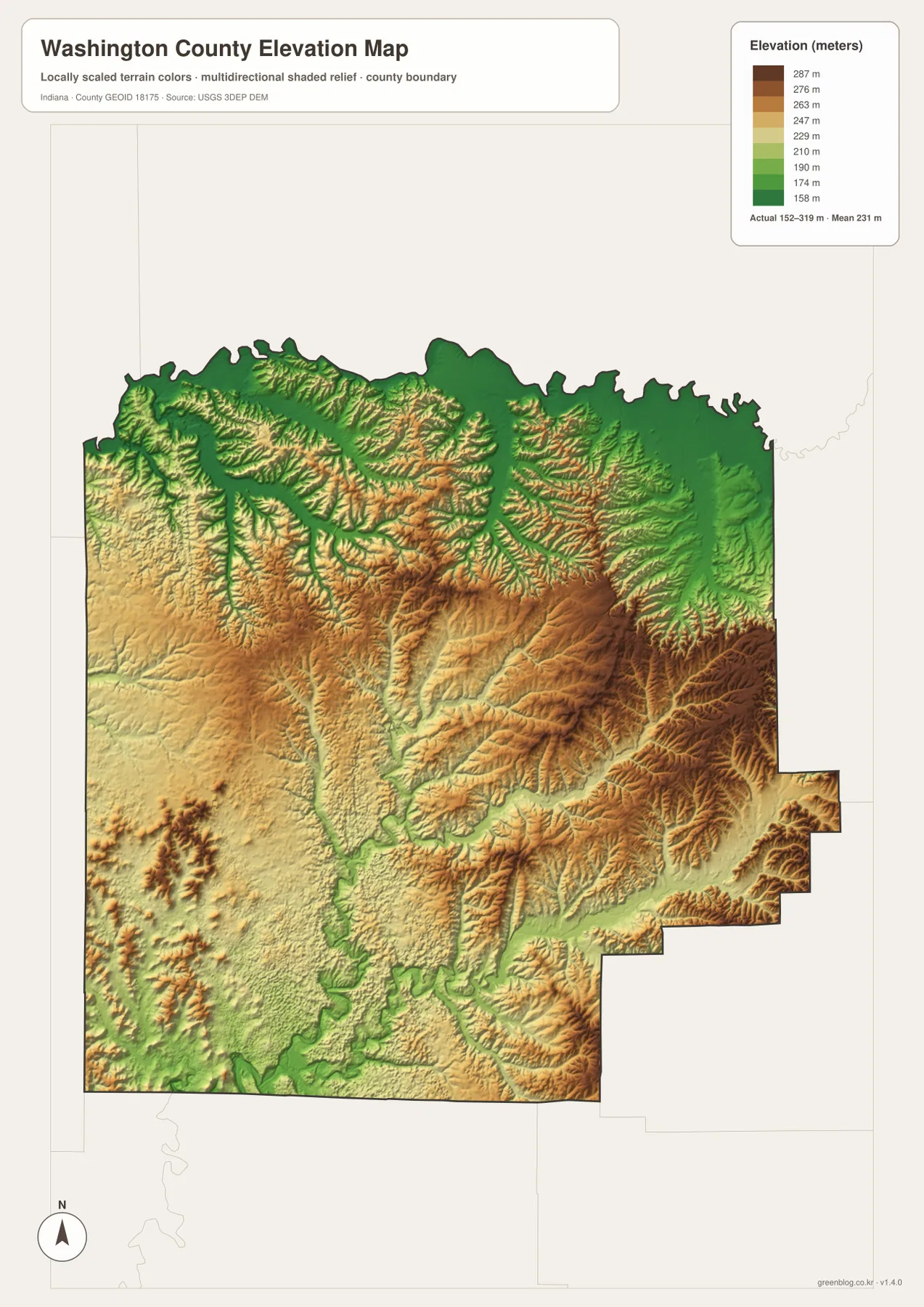
The eastern uplands are not one flat block. Blue River Middle Fork and South Fork Blue River cut narrow green valleys into the brown terrain, leaving short ridges between them. The repeated ridge-and-hollow pattern is especially clear in the southeast, where elevation changes quickly over short distances.
The central and western parts of the county are generally less elevated than the darkest eastern ridges, but they are still broken by many small drainage lines. The north also contains a mix of lower Muscatatuck and creek corridors beside higher hills. Salem sits near the middle of these changes and works well as a reference for comparing the different terrain zones.
The relief image is intended for broad countywide comparison rather than surveyed point elevations. For an exact height at a Washington County building, road point, field, or parcel corner, use the underlying elevation dataset or a professional survey.
Keep Salem fixed while comparing roads, rivers, and elevation
For basic orientation, start with Salem and Routes 60, 160, and 135. The city view is cleaner when the goal is simply to compare New Pekin, Campbellsburg, Little York, Saltillo, and Livonia around the county seat. Once those locations are familiar, Canton, Fredericksburg, and the outer road network become easier to place.
For the physical landscape, find Muscatatuck River and the Blue River system first, then add Twin Creek, Buffalo Creek, Delaney Creek, and the small lakes. Open the elevation map at the same locations and the pattern becomes clear: the main river and creek corridors stay low while the eastern and southeastern hills rise sharply around them.
The page uses smaller WebP previews for quick browser viewing. For Washington County, the ZIP preserves four full-resolution JPG originals—general county, city, terrain-and-water, and elevation—at 2572 by 3638 pixels each. Those files retain more detail for A3 output and for zooming in on route numbers, creek names, and lake labels.
A practical comparison routine is to keep Salem fixed, trace Route 60 toward the west and Route 135 toward the south, follow the Blue River forks on the water view, and finish by comparing the low green valleys with the higher eastern ridges.
Frequently Asked Questions
What is the easiest place to use as a starting point on the Washington County maps?
Salem is the best starting point because Routes 60, 160, and 135 provide clear directions toward the western, eastern, and southern parts of the county. From Salem, New Pekin, Campbellsburg, Little York, and Livonia are much easier to place.
Are Blue River and its named forks the same waterway?
They belong to the same broader Blue River system, but the supplied water map labels the main Blue River, West Fork Blue River, Blue River Middle Fork, and South Fork Blue River as distinct channels or branches. Their locations should therefore be followed separately on the map.
Where does the elevation map show the highest-looking terrain?
The broadest high tan-brown terrain appears across the east and southeast, while Blue River and many creek valleys remain lower. The legend reports an actual elevation range of about 152–319 meters and a mean of 231 meters.
Map File Information
The ZIP contains the high-resolution JPG originals for Washington County’s general, city, terrain-and-water, and elevation views. Choose these files when you need to enlarge route numbers, creek labels, lake names, or prepare an A3 print.
- Printable Size: 2572×3638 px each
Related Maps
Sources and References
The place, road, water, and elevation descriptions above are based on the supplied Washington County maps and asset information. The references below point to official boundary, water, and elevation sources for readers who need more detailed source data.
- U.S. Census Bureau TIGER/Line Shapefiles – official geometry for county boundaries, roads, and named places
- USGS National Hydrography – source information for Muscatatuck River, Blue River, creeks, and mapped lakes
- USGS 3D Elevation Program – elevation-source information for the county relief surface
Green Map creates custom-edited map images using open geographic data sources such as geoBoundaries, Natural Earth, OpenStreetMap, and government open data.
These maps are edited visual materials, not raw data files, and are provided for education, documents, presentations, and graphic reference.