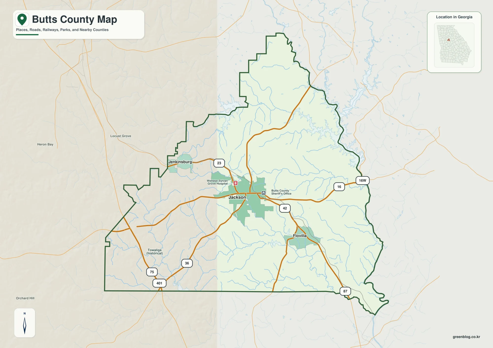
Vigo County is organized around Terre Haute and the Wabash River, which passes between Terre Haute and West Terre Haute before continuing south through a broad central valley. US 41 runs north–south through the main city, while US 40 and I-70 cross the river and provide strong east–west references. North Terre Haute lies farther up the US 41 corridor, Seelyville sits east of the urban core, and Riley is farther southeast. This Vigo County Map page connects those places with Wabash River, Coal Creek, Lost Creek, Otter Creek, Honey Creek, several small lakes, and a relief surface ranging from about 134 to 260 meters. Below, you can download Vigo County’s four 2572×3638 high-resolution JPG originals in one ZIP, keeping Terre Haute-area road, creek, and relief details clear for zooming or A3 printing.
Terre Haute and the Wabash River are the easiest fixed references. West Terre Haute sits immediately across the river, while US 40 and I-70 connect the two sides at different points. US 41 continues north toward North Terre Haute and south through the main urban area. Routes 46 and 159 help place Riley on the southeast side, and Route 63 provides another useful reference southwest of the city.
The elevation image shows why the central river corridor stands out so strongly. The legend reports an actual range of about 134 to 260 meters and a mean of 165 meters. Green low ground follows the Wabash valley through the middle of the county and expands toward the southwest, while higher tan and brown ridges occupy much of the northwest, east, and southeast. Creek valleys cut through those uplands on both sides of the river.
Table of Contents
Terre Haute brings the main road crossings together at the Wabash River
Terre Haute is the clearest starting point on the general county map. US 41 runs north–south through the city, while US 40 approaches from West Terre Haute and crosses the Wabash River. I-70 makes a second east–west crossing farther south before meeting the road network on both sides of the city. Those three routes provide a simple framework for understanding most of the central county.
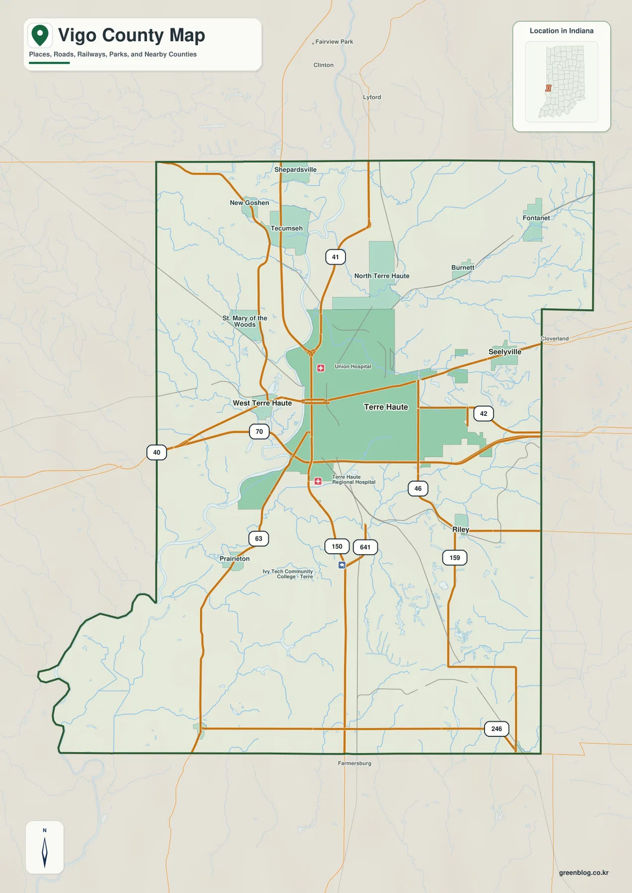
North of the urban core, North Terre Haute lies along the US 41 side. New Goshen, Tecumseh, and Shepardsville appear farther north and northwest, with St. Mary of the Woods providing another western place reference. Roads become less dense outside the city, but the stream network becomes more visible, especially in the northwest.
Seelyville sits east of Terre Haute, while Riley lies farther southeast near Routes 46 and 159. Fontanet and Burnett are separated farther northeast, and Route 42 crosses the eastern side of the county. The spacing between place names increases away from Terre Haute, making the transition from urban center to rural creek country easy to see.
South of Terre Haute, Prairieton lies near Route 63, with Routes 150 and 641 providing additional north–south references. Route 246 appears near the southeastern edge. Use the general view for relative positions, road directions, and county shape; current construction or temporary travel restrictions should be checked with a live transportation source.
Two 5-mile links and one 6-mile link show the urban area around Terre Haute
The city-connections view uses Terre Haute as the hub. West Terre Haute is shown about 5 miles to the west, Seelyville about 5 miles to the east, and Riley about 6 miles to the southeast. These are direct distances, not driving mileage, so they are most useful for comparing direction and spacing rather than planning a road route.
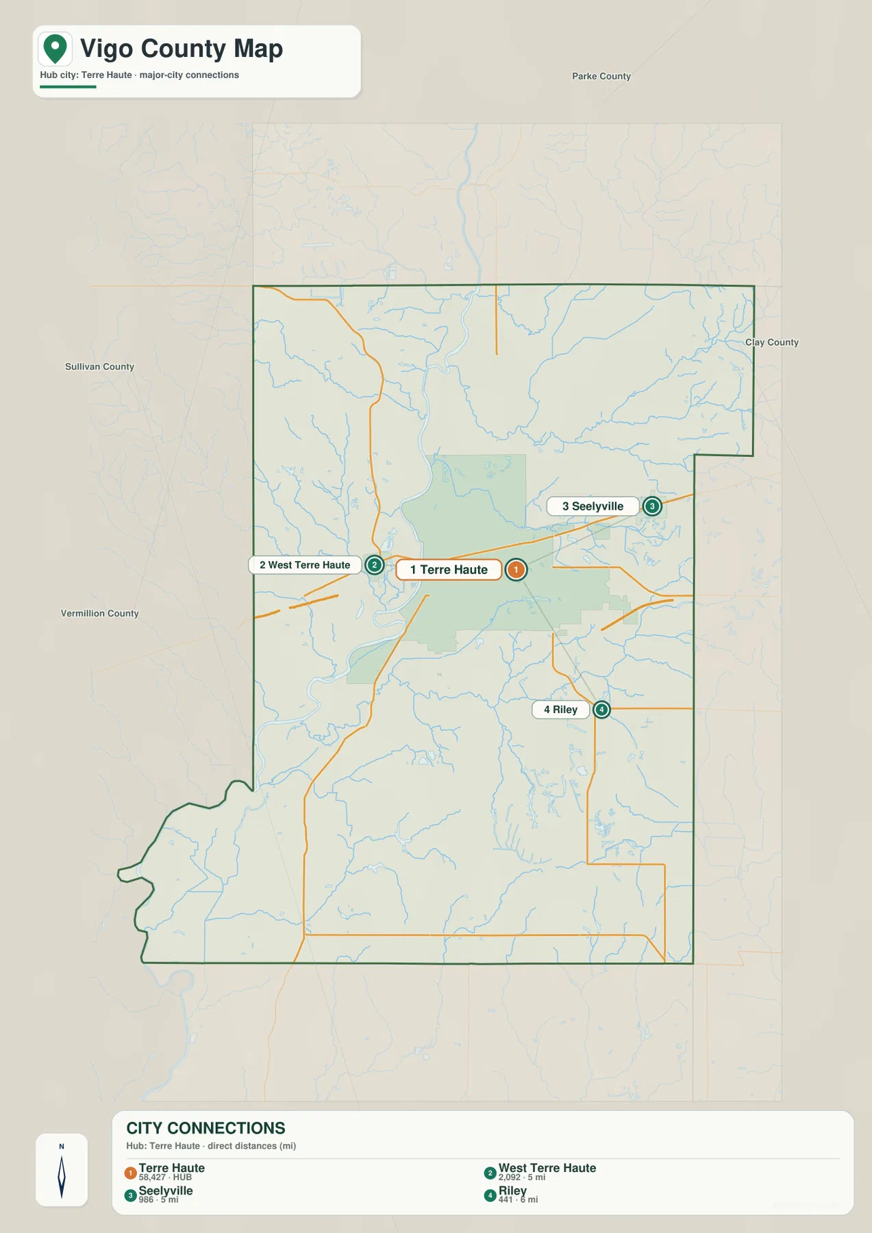
The equal 5-mile labels make West Terre Haute and Seelyville a useful directional pair. West Terre Haute lies across the Wabash River, while Seelyville is on the opposite side of the central urban area. Riley is only slightly farther away but shifts the comparison toward the southeast, where the road and relief patterns become more rural.
The CITY CONNECTIONS panel also prints numeric values beside the place names, but the supplied package does not identify a statistical year or separate source for those numbers. This page therefore does not present them as current official population. A recent U.S. Census release should be used when current population figures are needed.
Sullivan, Vermillion, Parke, and Clay counties are labeled around the outside of the city view. Those neighboring names help place West Terre Haute near the western edge and Seelyville and Riley toward the east and southeast. They also emphasize how the Terre Haute area sits near the middle of a county that extends well beyond the urban core.
Wabash River forms the central valley while creeks cut in from both sides
Wabash River is the dominant water feature on the terrain-and-water map. It enters from the north, passes through the central Terre Haute area, and bends toward the southwest. Coal Creek and Sugar Creek occupy the western and northwestern side, while Lost Creek and Otter Creek approach the central valley from the east and northeast.
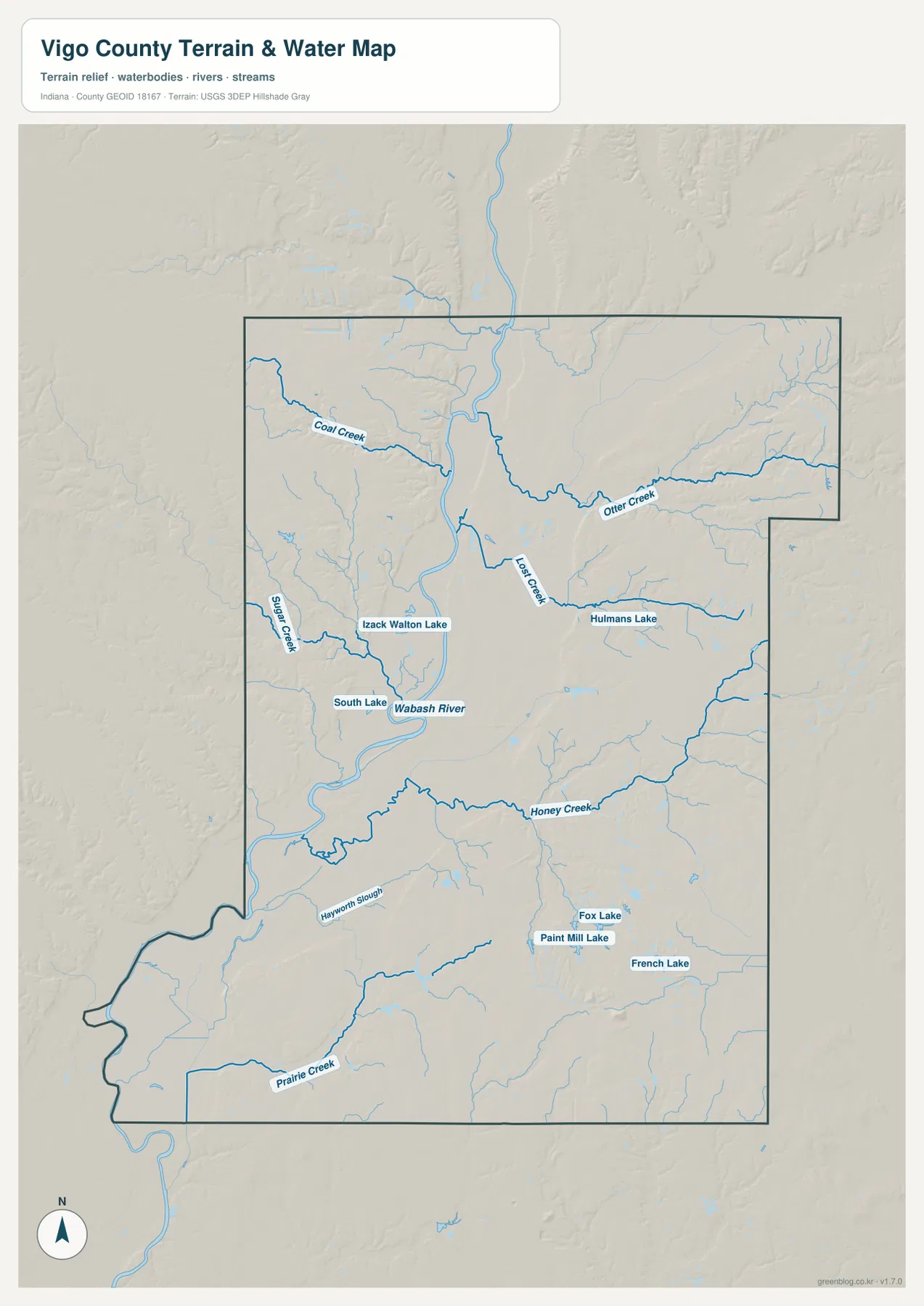
Coal Creek follows a long route through the northwest, and Sugar Creek provides a second western tributary farther south. Lost Creek cuts through the center, while Otter Creek runs across the northeastern and eastern interior toward the Wabash side. Once the Wabash is fixed on the map, the tributaries are much easier to sort by which side of the river they occupy.
Honey Creek crosses the southern half from east toward the central lowland, while Prairie Creek is labeled farther south. Hayworth Slough appears near the southwestern river country. Fox Lake, Paint Mill Lake, and French Lake are separate small water bodies in the southeast, with Hulmans Lake and South Lake adding additional local references closer to the center.
Use this hydrology view to locate Vigo County rivers, creeks, sloughs, and lakes at county scale. It is not intended to define flood limits, parcel boundaries, legal water lines, water depth, or navigation conditions; those questions require current agency data created for those purposes.
The 134–260 meter surface drops into a long central Wabash valley
The elevation legend gives Vigo County an actual range of about 134 to 260 meters and a mean of 165 meters. The broadest low terrain follows the Wabash River through the middle of the county and widens toward the southwest. The valley floor is green, while yellow, tan, and brown rise quickly on both the western and eastern sides.
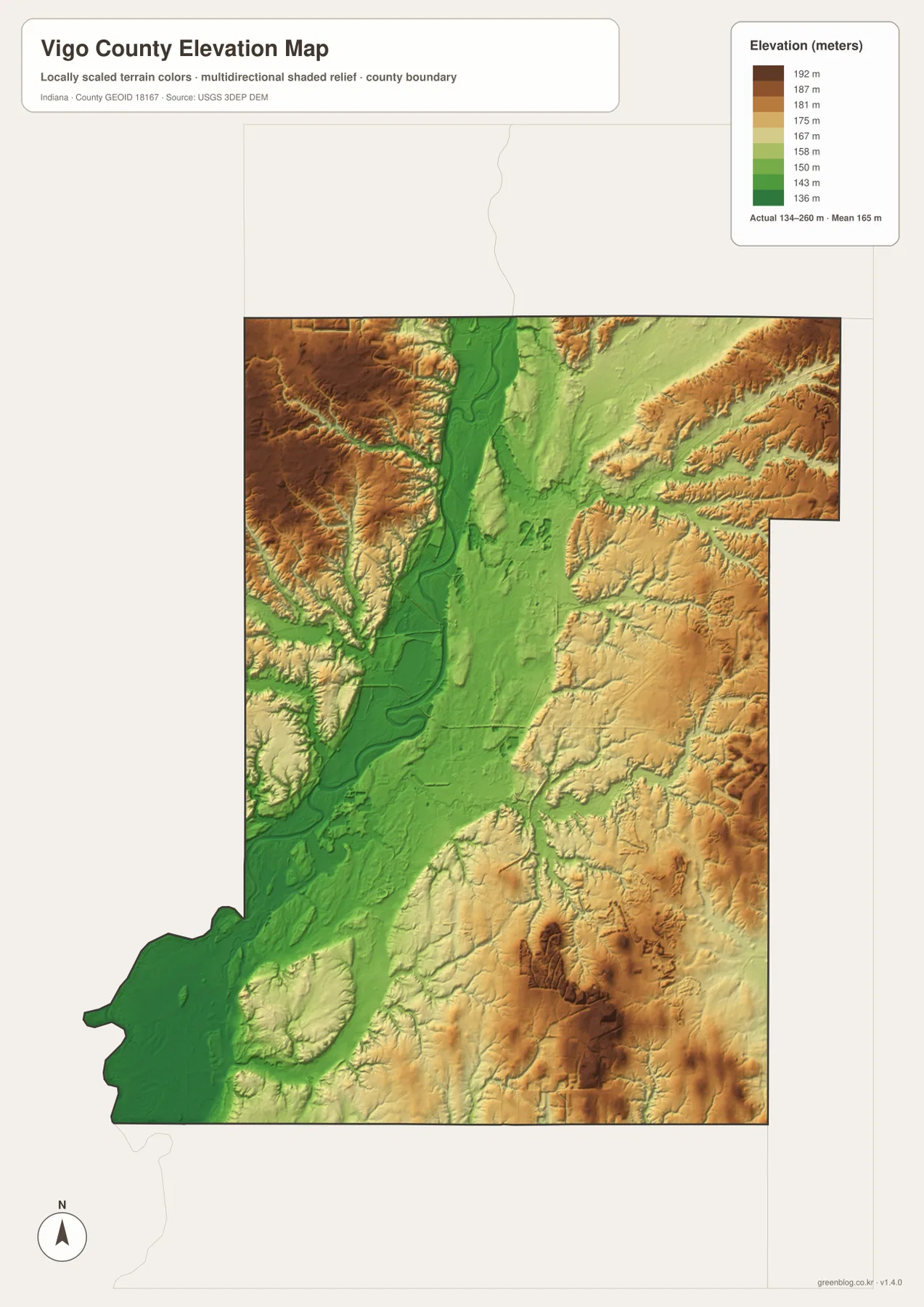
The northwest contains broad higher terrain cut by Coal Creek, Sugar Creek, and smaller tributaries. Those stream valleys appear as green corridors inside the tan and brown surface. The eastern and northeastern uplands show the same pattern around Otter Creek and other channels that descend toward the central valley.
The southeast includes some of the darkest high ground on the map, while Honey Creek and nearby channels create lower passages through it. By contrast, the southwestern Wabash side stays broadly green and low. The county therefore reads most clearly as a long river valley bordered by higher terrain on both sides rather than a landscape that rises in only one direction.
The elevation image is intended for broad comparison across Vigo County rather than surveyed point elevations. If you need the exact elevation of a building, road point, field, or parcel corner, use the underlying elevation data or a professional survey rather than this county overview.
Keep Terre Haute fixed while comparing roads, water, and relief
For basic orientation, start with Terre Haute, West Terre Haute, US 41, US 40, and I-70. The city-connections view is cleaner when the question is how West Terre Haute, Seelyville, and Riley are positioned around the hub. Once those directions are familiar, North Terre Haute and the outer road network become easier to place.
For the physical landscape, locate Wabash River first and then add Coal Creek, Lost Creek, Otter Creek, and Honey Creek. Open the elevation map at the same locations and the relationship becomes clear: the main river corridor is low, while higher ridges surround it and are cut by tributary valleys.
The page uses smaller WebP previews for quick browser viewing. For Vigo County, the ZIP preserves four full-resolution JPG originals—general county, city-connections, terrain-and-water, and elevation—at 2572 by 3638 pixels each. These files retain more detail for A3 output and close inspection of road numbers, creek names, and small lake labels.
A practical comparison routine is to keep Terre Haute fixed, locate the major road crossings, trace Wabash River through the county, and finish by comparing the green central valley with the higher northwest and southeastern terrain.
Frequently Asked Questions
Are the 5-mile and 6-mile labels from Terre Haute driving distances?
No. The city-connections map shows direct distances: about 5 miles to West Terre Haute, about 5 miles to Seelyville, and about 6 miles to Riley. Actual driving mileage can be longer because roads and river crossings do not follow the straight connection lines exactly.
Why is Wabash River such an important reference on the Vigo County maps?
Wabash River passes between Terre Haute and West Terre Haute and forms the county’s broad central lowland. The road, water, and elevation views all become easier to understand once the river is used as the main geographic reference.
Where does the elevation map show the highest-looking terrain?
Higher tan-brown terrain is widespread in the northwest, east, and southeast, while the Wabash corridor remains low and green. The legend reports an actual elevation range of about 134–260 meters and a mean of 165 meters.
Map File Information
The ZIP contains the high-resolution JPG originals for the Vigo County general, city-connections, terrain-and-water, and elevation views. Choose these files when you need to enlarge route numbers, creek labels, or prepare an A3 print.
- Printable Size: 2572×3638 px each
Related Maps
Sources and References
The place, road, water, and elevation descriptions above are based on the supplied Vigo County maps and asset information. The references below point to official boundary, water, and elevation sources for readers who need more detailed Vigo County source data.
- U.S. Census Bureau TIGER/Line Shapefiles – official geometry for county boundaries, roads, and named places
- USGS National Hydrography – source information for Wabash River, Vigo County creeks, and mapped inland waters
- USGS 3D Elevation Program – elevation-source information for the county relief surface
Green Map creates custom-edited map images using open geographic data sources such as geoBoundaries, Natural Earth, OpenStreetMap, and government open data.
These maps are edited visual materials, not raw data files, and are provided for education, documents, presentations, and graphic reference.