Download the high-resolution Tipton County JPG maps in one ZIP from the file box below. The package includes the general county, city-connections, terrain-and-water, and elevation views at 3638×2572 pixels each. Around Tipton, Route 19 provides the main north–south reference and Route 28 crosses the county from the Kempton side toward Hobbs. Windfall City, Sharpsville, and Kempton sit in three different directions from the county seat, while the physical maps add Mud Creek, Turkey Creek, Cicero Creek, a dense system of named drainage ditches, and a gentle 249–284 meter west-to-east relief change.
This Tipton County Indiana map set is easiest to follow by keeping Tipton fixed in the middle. Route 31 runs farther west, and Route 213 gives the eastern side another north–south line. Windfall City lies northeast of Tipton, Sharpsville northwest, and Kempton farther west near the boundary. The road grid is fairly regular, but the water channels cut across it in much less uniform shapes, making the two map views useful for different details.
The relief surface is subtle rather than dramatic. The legend reports an actual range of about 249 to 284 meters and a mean of 268 meters. The west and southwest carry more tan and brown higher ground, while green lower terrain becomes broader toward Hobbs and Windfall City on the east and northeast. Creeks and ditches create slightly lower corridors within both sides of the county.
Table of Contents
Route 19 and Route 28 make Tipton the easiest road reference
Tipton sits close to the middle of the county and is easy to identify from the intersection of the main numbered roads. Route 19 passes north–south through the city, and Route 28 crosses from the Kempton side toward Hobbs. IU Health Tipton Hospital is also labeled nearby, providing another fixed point. Once the central crossroads is clear, the outer communities fall into a simple countywide arrangement.
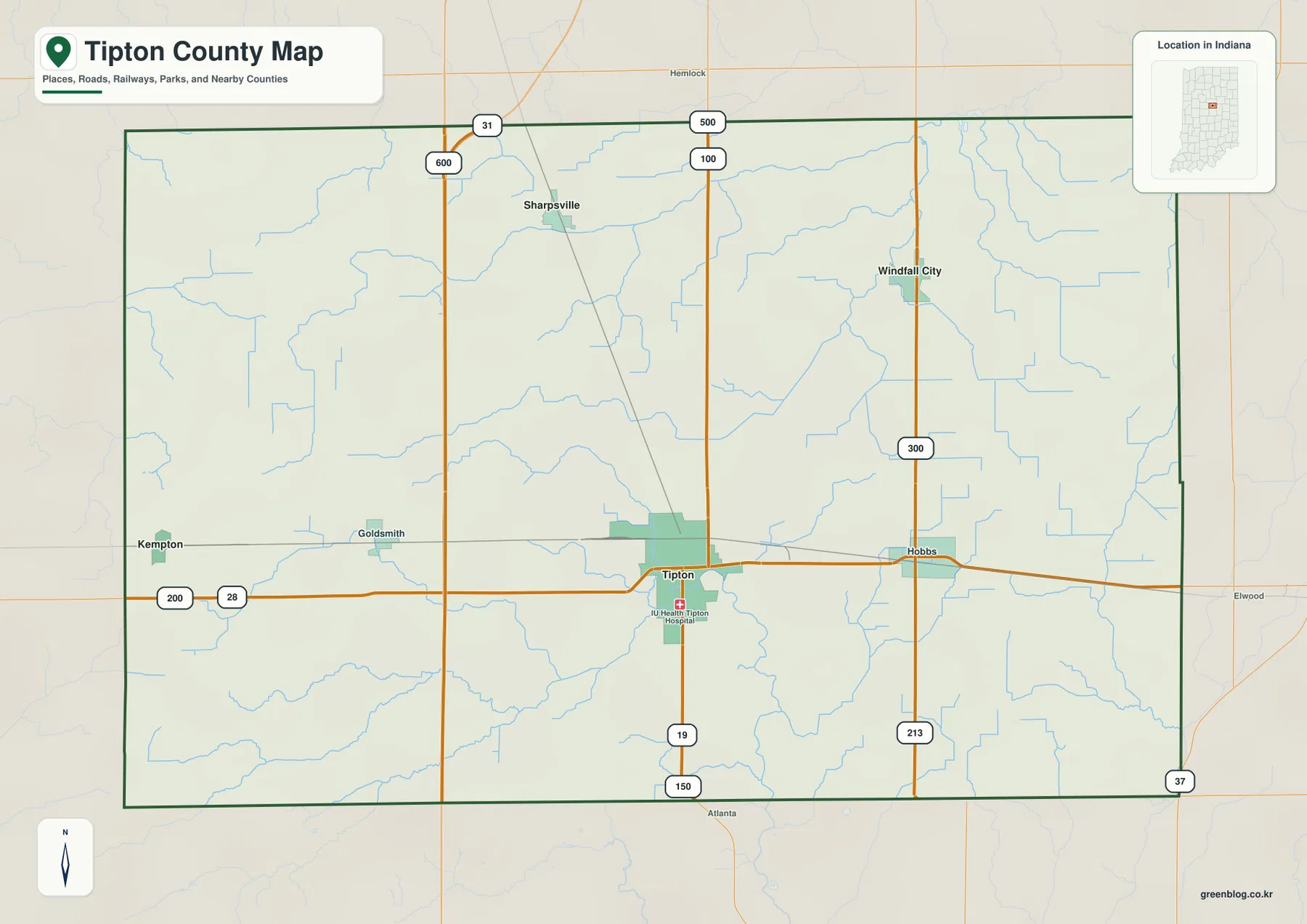
West of Tipton, Route 31 runs north–south and helps place Sharpsville and Goldsmith. Kempton lies closer to the western boundary on the Route 28 side. The road geometry is comparatively straight, which makes the irregular creek and ditch system look even more noticeable when the water view is opened.
Windfall City occupies the northeastern part of the county near the road marked 300, while Hobbs lies farther south and closer to the county center. Route 213 continues north–south on the eastern side, with Elwood labeled beyond the county boundary. The eastern road references also line up with the lower green side of the elevation map.
Use the general map to compare named places, numbered roads, and the county boundary. It is not a live traffic source, so temporary road work, closures, and changing travel restrictions should be checked with current transportation information before a trip.
Two 7-mile links point in opposite directions from Tipton
The city-connections view reduces the county to Tipton and three outer communities. Windfall City is marked about 7 miles northeast of the hub, Sharpsville about 7 miles northwest, and Kempton about 10 miles west. These are direct distances, not driving mileage, so they are most useful for comparing direction and spacing rather than planning a route.
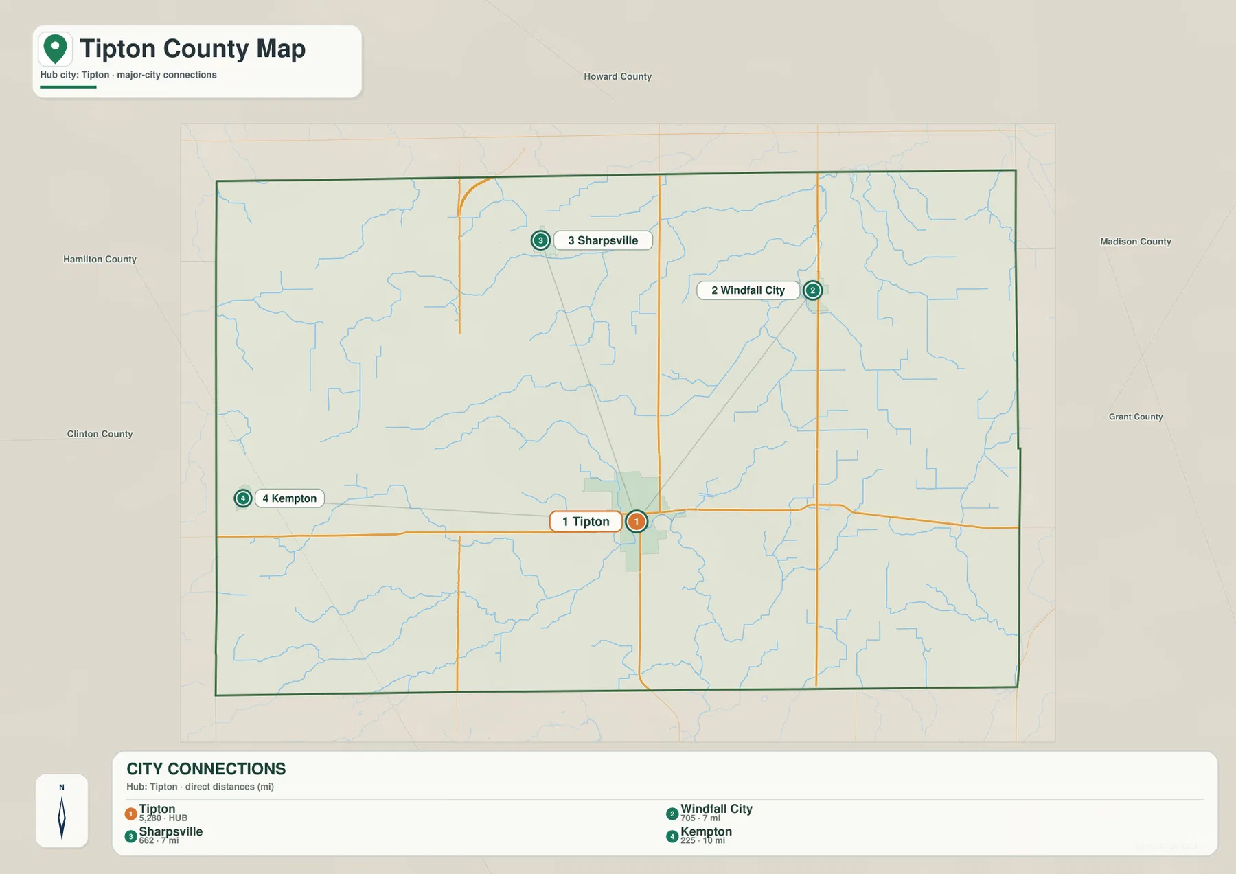
The equal 7-mile labels make Windfall City and Sharpsville a useful directional pair. One lies northeast and the other northwest, while Kempton extends the comparison farther west. When the general road map is reopened, those simple lines turn into distinct route patterns around Route 31, Route 28, and the northeastern road grid.
The graphic also prints small numeric values beside the place names, but it does not state their statistical year or provide a separate source. This article therefore does not treat those values as current population. A recent U.S. Census release is the appropriate source when current population counts are needed.
Howard, Hamilton, Madison, Grant, and Clinton counties are labeled around the outside of the city view. Windfall City sits closer to the northeastern side, while Kempton approaches the west. Those neighboring labels provide useful context before returning to the detailed road and drainage maps.
Creeks and named ditches form the county’s most detailed natural network
Tipton County does not have one dominant river or a large lake system on the supplied water map. Instead, Mud Creek curves across the northwest, Cottingham Ditch crosses the north, and Buck Creek and Turkey Creek occupy the central interior. The number of named channels is one of the most distinctive features of the map.
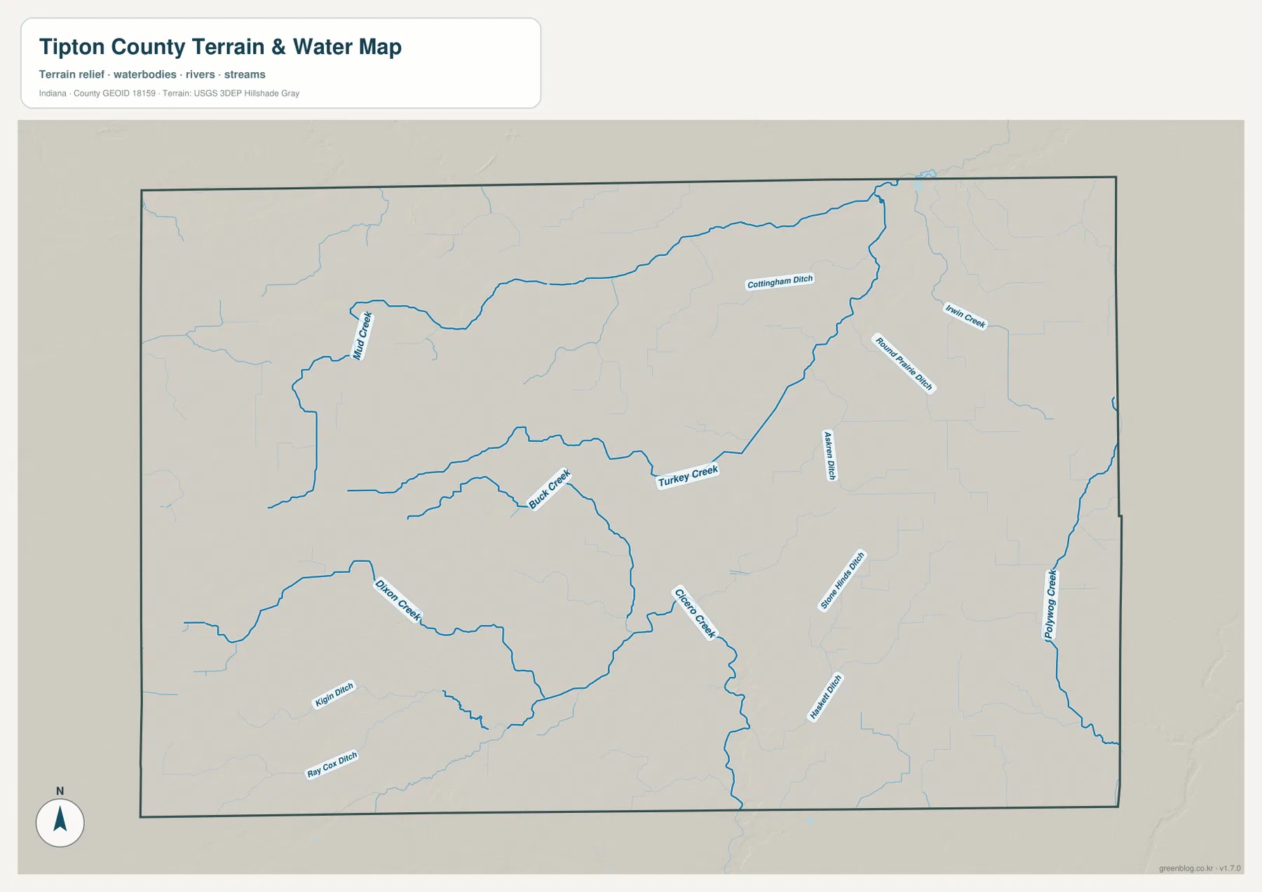
Cicero Creek becomes a stronger reference south of the county center, while Dixon Creek follows a separate route in the southwest. On the eastern side, Austin Ditch, Round Prairie Ditch, and Stone House Ditch show straighter segments than the naturally curving creeks. Their different shapes make it easier to distinguish the channel types visually.
Haskett Ditch extends across the south, and Kiln Ditch and Ray Cox Ditch are labeled farther southwest. Because the county lacks a large central water body, these smaller channels provide most of the local water references. They are also useful when comparing the water map with the elevation map, where many channels follow slightly lower strips of terrain.
This hydrology view is intended to show the county-scale location of creeks and named drainage channels. It does not establish flood limits, parcel boundaries, legal drainage responsibilities, or site-specific water depth. Those questions require the current records maintained by the relevant agencies.
The 249–284 meter surface trends from higher west to lower east
The elevation legend gives Tipton County an actual range of about 249 to 284 meters and a mean of 268 meters. Tan and brown are more extensive across the west and southwest, while green lower ground spreads across the east and northeast. The total elevation range is modest, but the countywide direction is still easy to see.
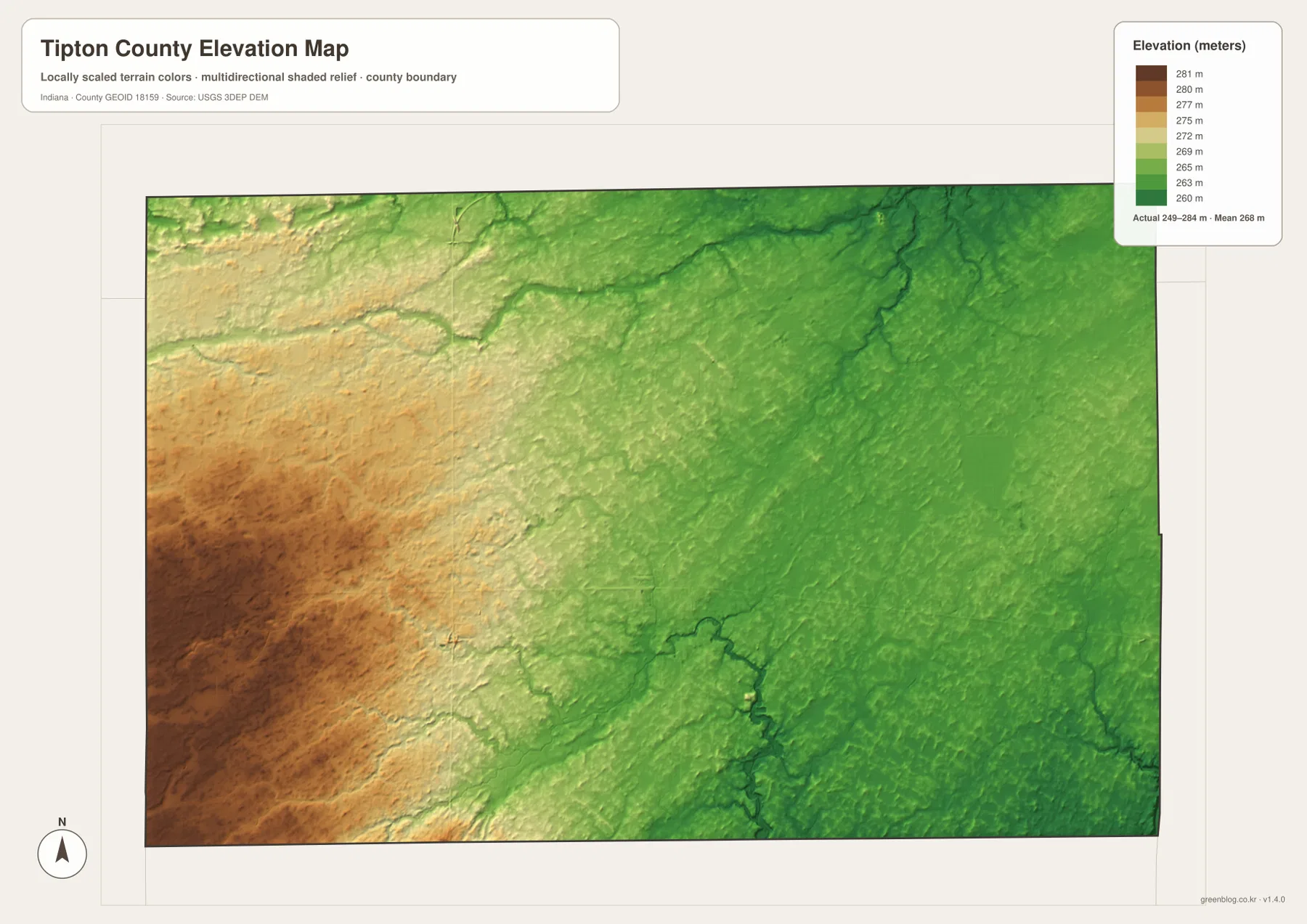
The western high side is not perfectly flat. Creek and ditch corridors appear as slightly lower green or light-green paths through the tan surface. The eastern side is lower overall, but those same drainage channels still create subtle local depressions inside the broader green area.
Tipton lies near the transition between the two sides. Heading toward Kempton or Sharpsville brings more higher colors into the map, while the Hobbs and Windfall City direction becomes progressively greener. The relief change is gentle, but it explains why the dense drainage network occupies a landscape with only limited overall height variation.
The elevation image is intended for broad comparison across Tipton County rather than surveyed point elevations. For an exact height at a road point, field, building site, or parcel corner, consult source elevation data or professional survey measurements.
Keep Tipton fixed while moving from roads to channels and relief
For basic orientation, start with Tipton and Routes 19 and 28. The city-connections view is useful when the question is simply how Windfall City, Sharpsville, and Kempton are positioned around the county seat. Once those directions are familiar, Hobbs, Goldsmith, Route 31, and Route 213 become much easier to place.
For water features, find Mud Creek, Turkey Creek, Cicero Creek, and the larger named ditches before looking at the smaller channels. Then open the elevation map at the same locations. The western side stays broadly higher, while the eastern drainage network occupies the lower green half of the county.
The page uses smaller WebP previews for quick browser viewing. The ZIP keeps the full-resolution JPG originals for the county, city-connections, terrain-and-water, and elevation views, each measuring 3638 by 2572 pixels. Those originals are better suited to A3 output and close inspection of route numbers or small drainage labels.
A simple comparison routine is to keep Tipton fixed, locate Routes 19 and 28, compare Windfall City and Sharpsville on the city view, trace Turkey Creek and Cicero Creek on the water map, and finish by comparing the higher western browns with the lower eastern greens.
Frequently Asked Questions
Are the 7-mile and 10-mile labels from Tipton driving distances?
No. The city-connections view uses straight-line distances from Tipton: about 7 miles to Windfall City, about 7 miles to Sharpsville, and about 10 miles to Kempton. Road mileage can be longer because actual routes do not follow those straight connection lines.
Why does the Tipton County water map show so many named ditches?
The supplied map labels multiple drainage channels, including Cottingham, Austin, Round Prairie, Stone House, Haskett, Kiln, and Ray Cox ditches. Together with Mud, Buck, Turkey, and Cicero creeks, they create the county’s most detailed water pattern.
Which side of Tipton County is higher?
The west and southwest are higher overall, while the east and northeast are lower. The elevation legend reports an actual range of about 249–284 meters and a mean of 268 meters.
Map File Information
The ZIP contains the high-resolution JPG originals for the Tipton County general, city-connections, terrain-and-water, and elevation views. Use these files when you need to enlarge road numbers or drainage labels or prepare an A3 print.
- Printable Size: 3638×2572 px each
Related Maps
Sources and References
The place, road, water, and elevation descriptions above are based on the supplied Tipton County maps and asset information. The official references below can be used when more detailed source data are needed.
- U.S. Census Bureau TIGER/Line Shapefiles – official reference for county boundary, road, and place geometry
- USGS National Hydrography – official source information for named creeks and drainage channels
- USGS 3D Elevation Program – official elevation source and program information
Green Map creates custom-edited map images using open geographic data sources such as geoBoundaries, Natural Earth, OpenStreetMap, and government open data.
These maps are edited visual materials, not raw data files, and are provided for education, documents, presentations, and graphic reference.